Categories
- 31May 31, 2026
Sydenham Bruce Trail E2E Run - Day 8 of 8 Only
https://hikes.brucetrail.org/event/sydenham-bruce-trail-e2e-run-day-8-of-8-only/Sorry, the registration cut-off time for this hike has been reached.Not a member? Click here to join today!Hike open to BTC Members only.
Hosting Club: Sydenham, Peninsula
Category: Sydenham E2E Trail Run
Location (Google Maps): Day 8 of the E2E Trail Run of the Sydenham Bruce Trail section. Meeting at Blantyre BTC Parking Lot.Hike Leader(s): Margie Gloade; Natalie Mechalko Click here to contact Hike Leader(s)
Pace: Fast (5.5 – 7.0 km/h+): A quick pace maintained by experienced hikers or trail runners.
Terrain: Difficult: Steep ascents/descents, rocky scrambling, and some rugged escarpment paths.
Distance: About 21 kmDescription
This is a single-day registration – Day 8 of 8.The Sydenham Bruce Trail Club (SBTC), in partnership with the Peninsula Bruce Trail Club (PBTC), is excited to offer its first-ever trail running Sydenham End-to-End series in 2026. Join the fun for one of the eight days in this trail running series! The trail running Sydenham E2E series will take place over 4 weekends and 8 days, starting at 7:30am. Below is the start and end location and estimated distance for this day (subject to change slightly). The group will meet at the end location, and carpool to the start of each day’s route. You are expected to participate in shuttling vehicles.
Please carefully read the details below to understand the logistics, costs, important notes, and fitness required for this challenge.
Sunday, May 31, 2026: Massie Hills Parking off 6th Concession S to Blantyre BTC Parking Lot; ~21km.
- When you register here, you are registering for only one day in the series. (You also have the option of registering for the whole series for $60 even if you aren’t able to make all eight days).
- These are group trail runs. It is not a race. It is not a hike. There may be a couple different pace groups that naturally form, but you will be expected to stay with a group and wait to regroup at key locations. Runners are expected to remain between the lead runner and the sweep at all times. Anticipate each day to be running for about 3+/- hours, at a pace ranging from 7-9 min./km.
- Participants are expected to have some experience trail running as this is difficult terrain. There are also some roads, and some active farm fields. In some locations throughout Sydenham, trail running will not be permitted near livestock. On roads, runners are expected to follow standard Highway Traffic Act regulations, crossing safely and running on the shoulder, in single file, facing oncoming traffic.
- Mandatory gear includes a whistle and minimum 250ml of water carrying capacity. Trail runners will need to carry their own water and fuel.
- At approximate mid-way points each day, there will be volunteer support arranged so you can fill up water bottles. Some snacks (e.g. oranges, bananas, pretzels, cookies, water) will be provided but please plan to be self-sufficient.
- Exercise care and caution and common sense on trails, especially when passing other trail users. Let others know you are coming and that you intend to pass. Headphones/earbuds are not permitted while participating in this group run.
- Participants must be age 16 years or older.
- Dogs are not permitted.
- This trail run is for BTC members only. To become a member, click here: https://brucetrail.org/.
- The designated meeting points will not incur any personal parking fees but parking space is limited. Participants are encouraged to car pool whenever possible.
The single day fee is $20. This fee covers snacks, vehicle shuttle, volunteer support, and a donation to the PBTC hike program. There is also an option to register for the whole series ($60).
As per BTC policy, no refunds will be considered 30 days before the series starts (not after April 1, 2026).
The trail run will go ahead rain or shine, however, in extremely inclement weather, a date may be cancelled and rescheduled, ideally prior to the May 31st finish date.

Iroquoia BTC Naturalist Hike Series- Discovering Nature One Hike at a Time – Forest Bathing – Meet in the parking lot at 7:45am
https://hikes.brucetrail.org/event/iroquoia-btc-naturalist-hike-series-discovering-nature-one-hike-at-a-time-forest-bathing-meet-in-the-parking-lot-at-745am/Sorry, the registration cut-off time for this hike has been reached.Not a member? Click here to join today!Hosting Club: Iroquoia
Category: Iroquoia BTC Naturalist Hike Series : Discovering Nature, One Hike at a Time.
Location (Google Maps): Ancaster Little League parking area at 268 Jerseyville Rd West, Ancaster.Hike Leader(s): Ruth Moffatt Click here to contact Hike Leader(s)
Pace: Leisurely – 3km/hr or less, Medium – 3 to 4 km/hr
Terrain: Dependent on Conditions, Easy – Mostly flat and usually good footing, Moderate – Some hills and/or some poor footing
Distance: 8-10kmDescription
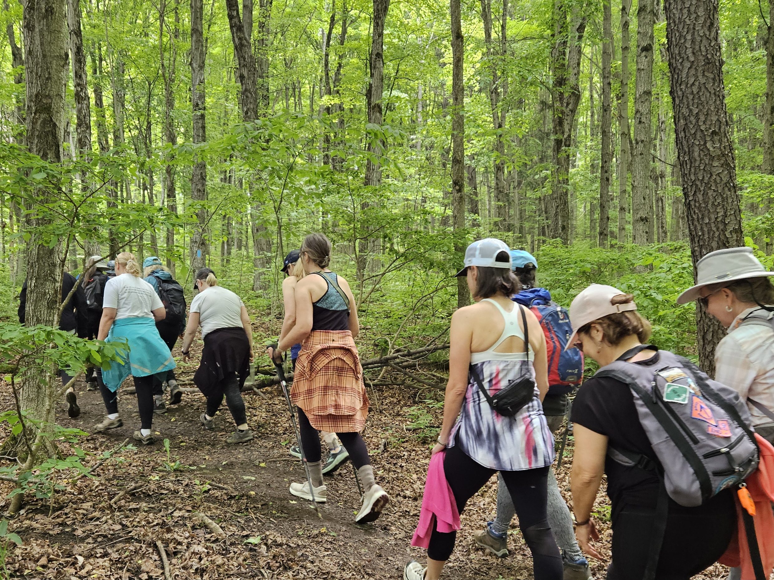
Please join us for an introduction to Forest Bathing as part of our Naturalist Hike Series.Forest bathing shinrinyoku, is a Japanese practise of spending calm intentional time in nature to improve health, well-being and relaxation. We will use all 5 senses to engage with our surroundings at the Dundas Valley Conservation area. Our movement will be leisurely and slow paced and in peace. We may sit down, we may close our eyes and we will listen without speaking. The benefits of Forest Bathing have been found to reduce blood pressure and boost immune function. Recommended reading is Forest Bathing by Dr. Qing Li.
Please bring snacks and water and mute your phones.
If your plans change, please cancel your registration so that someone from the waitlist can potentially join the hike.
To cancel your registration, here is a step by step:
– Sign into your account on the BTC website
– Click on My Hikes under your account
– This will take you to a list of hikes you have registered for
– Scroll down to the appropriate hike and cursor over to the far right hand column under the Action column.
– Click Cancel under the hike you wish to cancelAny questions may be directed through the link on this form.
Car Hike: Jefferson Forest and Bond Lake
https://hikes.brucetrail.org/event/car-hike-jefferson-forest-and-bond-lake-richmond-hill-13/Sorry, the registration cut-off time for this hike has been reached.Not a member? Click here to join today!Hosting Club: Toronto
Category: Car Hike
Location (Google Maps):1245 Bethesda Side Rd, Richmond Hill, ON L4E 1A2 ( Bethesda Trail Head Parking lot)
Hike Leader(s): Amir Alemohammad Click here to contact Hike Leader(s)
Pace: Moderate (3-4 km/hr)
Terrain: Flat, Hilly, Level 2 (Intermediate – some hills and uneven surfaces, rocks and roots underfoot), Variable
Distance (km): 15-16 kmDescription
Let’s roll the hills of the Jefferson Forest and around the Bond Lake. Every week we hike in Jefferson Forest, located in the heart of Richmond Hill, it boasts numerous hiking trails. This 3.5 hour hike can range from 14 to 15 kilometres, depending on the weather conditions. Remember to bring water, snacks, hiking boots, poles, and your camera. Not recommended for beginners. Park in the free Bethesda parking lot and avoid parking along the road. Dress appropriately for the weather. Difficulty Level: 2 (Moderate).Please arrive @7:45AM for start of 8:00AM.
This is a joint hike with the Oak Ridges Trail Association (ORTA).
what3words:
https://w3w.co/twisting.mailer.awakes
School Bus Hike: Hockley Valley
https://hikes.brucetrail.org/event/school-bus-hike-hockley-valley/Sorry, the registration cut-off time for this hike has been reached.Not a member? Click here to join today!Trip Information
Departure Time: 08:30
Return to City Time: 18:30
Departure Point: York Mills Bus PickupOptional Items
Pick up at HWY 400 & Major Mac ($0.01)Hosting Club: Toronto
Category: Bus Hike
Location (Google Maps): Hockley ValleyHike Leader(s): Martina Furrer, Celia Ho, Leila Damband, Roland Mark Click here to contact Hike Leader(s)
Pace: Brisk (4-5 km/hr), Moderate (3-4 km/hr)
Terrain: Hilly, Level 2 (Intermediate – some hills and uneven surfaces, rocks and roots underfoot), Variable
Distance (km): Fast (18 km), moderate (13 km)Description
Join us for an awesome hike with great views and fun hills. We will split into two groups and hike north from Hockley Valley Rd to Mono Centre. The moderate group will hike about 13 km and the fast about 18 km.Refreshments at Sonnen Hill (www.sonnenhill.com). Sit back, relax, and socialize with your hiking friends while you sip a fresh, cold, local brew (or non-alcoholic beverage) in their beautiful beer garden. Or walk up to their lookout for more great views (a 20 minute loop).
Departure 1: 10 York Mills Rd at 8:30 AM
Departure 2: HWY 400 & Major Mac Park and Ride at 8:50 AM
We hope to be back in the city by 6:30 PM.
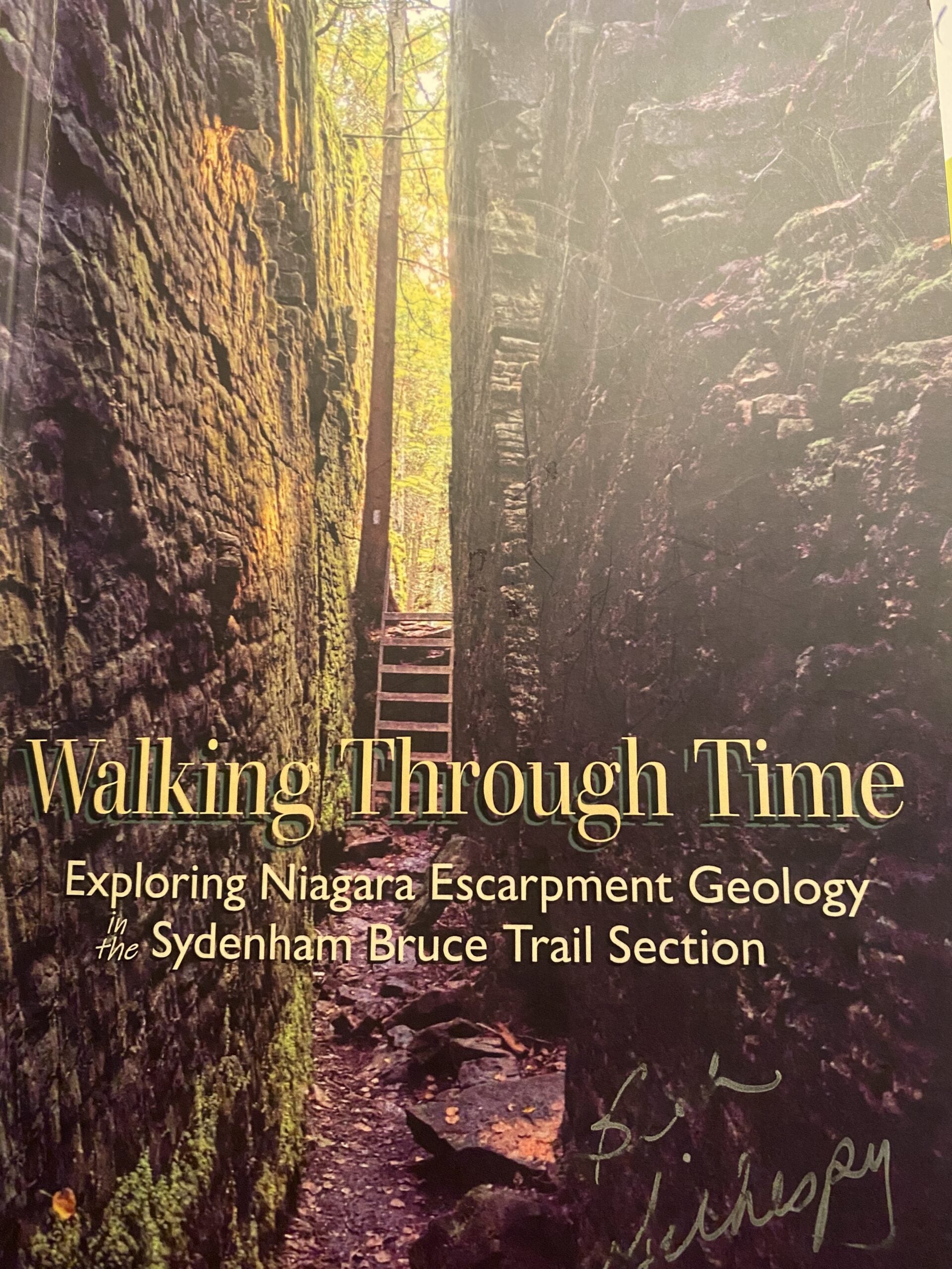
Geology Hike and Badge Series - Hope Bay
https://hikes.brucetrail.org/event/geology-hike-and-badge-series-hope-bay/Sorry, the registration cut-off time for this hike has been reached.Not a member? Click here to join today!Hosting Club: Peninsula
Category: Geology Hike
Location (Google Maps): Hope BayHike Leader(s): Beth Gilhespy Click here to contact Hike Leader(s)
Pace: Leisurely (2.0 – 3.0 km/h): A relaxed pace with frequent breaks and a focus on enjoyment., Medium (3.0 – 4.5 km/h): A comfortable pace for most hikers with steady progress.
Terrain: Moderate: Rolling hills, mild slopes and rocky paths.
Distance: 8.1Description
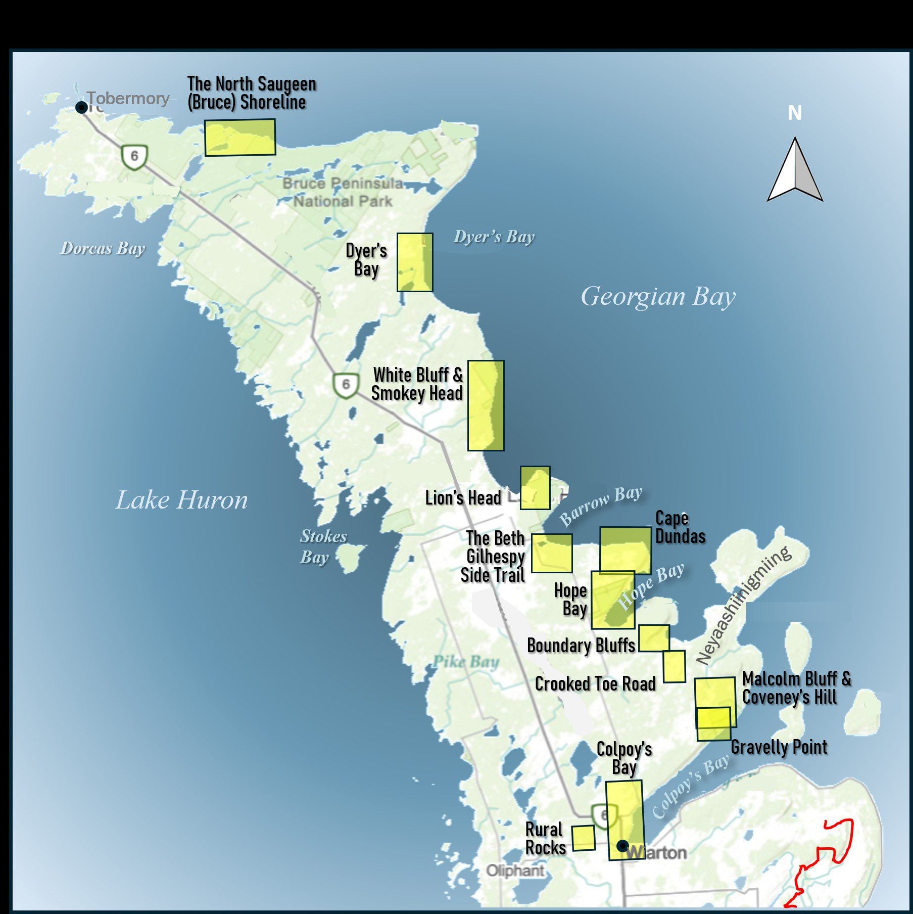
Join the adventure and earn the inaugural Peninsula Geology Badge! Over a stretch of 13 hikes and a couple of extra stops, we will explore the fascinating geology of the Peninsula to learn about the rocks, the shoreline features, glaciation, fossils and all things earthy. The 13 hikes are from the book “Walking Through Time – Exploring the Geology of the Saugeen (Bruce) Peninsula”. Having a copy will give you a lot of great information, but you do not have to purchase the book to attend and enjoy the hikes. Just bring your curiosity! We will make sure to hit all the locations that qualify for the beautiful new Walking Through Time – Saugeen (Bruce) Peninsula geology hike badge. If you would like to purchase a book I will have some available on the hikes, or you can pick one up from the BTC Head Office, at Ginger Press in Owen Sound, Suntrail Source for Adventure in Hepworth, the Shop at 84 Main in Lion’s Head and at Reader’s Haven in Tobermory.You are welcome to come on just a few of the hikes or on all of them, and the dates and hikes are as follows:
Date Geology Hike km
Saturday May 2, 2026 Colpoy’s Bay 9.0
Saturday May 9, 2026 Gravelly Point (am) and Rural Rocks (pm) 8.6
Saturday May 16, 2026 Malcolm Bluff 7.3
Sunday May 17, 2026 White Bluff/Smokey Head 11.8
Sunday May 24, 2026 Crooked Toe Road 5.5
Sunday May 31, 2026 Hope Bay 8.1
Sunday June 14, 2026 Boundary Bluffs 5.2
Saturday July 4, 2026 Cape Dundas 6.2
Saturday July 11, 2026 Beth Gilhespy Side Trail 7.6
Saturday August 8, 2026 Lion’s Head 11.0
Saturday August 15, 2026 Dyer’s Bay Loops 7.5
Saturday August 22, 2026 North Saugeen (Bruce) Shoreline 8.0
Meeting times will vary depending on the hike, but will generally be some time between 9 am and 10 am. Information on exact meeting times and locations will be sent out a few days prior to the hike.
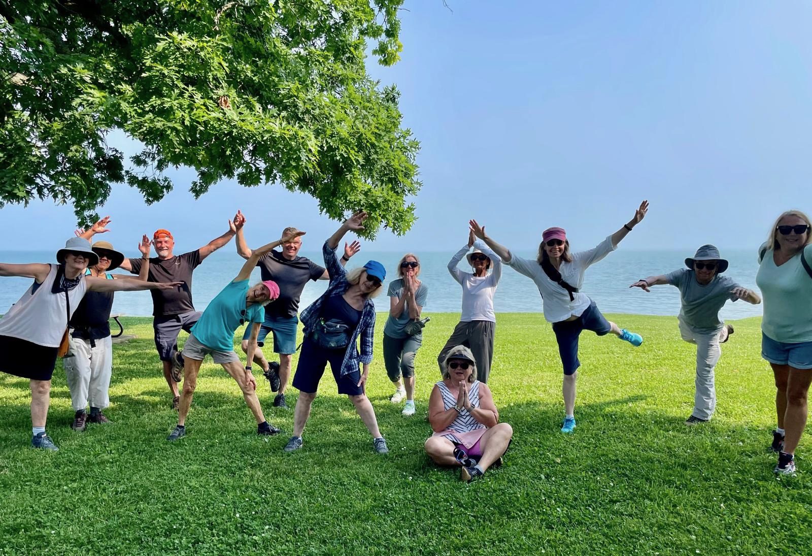
Yoga + Hike Fundraiser
https://hikes.brucetrail.org/event/yoga-hike-fundraiser-2/Sorry, the registration cut-off time for this hike has been reached.Not a member? Click here to join today!Hosting Club: Caledon Hills
Category: General
Location (Google Maps): Meet at the BTC parking lot, 713377 1st Line EHS, Mono. It is easier to go north on 1st Line from Side Road 5 than it is to go south on 1st Line from Hockley Road. 1st Line is not maintained between the parking lot and Hockley Road. It is best to aim for arriving around 9:15 am, so we can start our yoga session as close to 9:30 as possible. Thanks!Hike Leader(s): Elizabeth Ganong and Janice McLelland Click here to contact Hike Leader(s)
Pace: Leisurely – 3 km/hour or less
Terrain: Easy – mostly flat and usually good footing, Moderate – some hills and/or some poor footing
Distance: Approximately 4 kmDescription
Join us for the CHBTC’s Yoga + Hike Fundraiser happening at Riverside Woods. Led by Elaine Vallevand, we’ll start with an outdoor yoga session at 9:30 am. Bring your mat! Light refreshments will be provided following our yoga session. During this break, you will have time to put your mat in your vehicle and get ready to hike. By 11 am, we should be on the trails. The large group will be divided into two smaller groups to enable hikers to better enjoy our forest bathing inspired hike, approximately 4 km. The Marsh Marigolds are in bloom! Plan to be finished just after 12:30 pm.100% of the proceeds will support maintaining and preserving the Bruce Trail. Our kind and giving yoga instructor is donating her time, the refreshments are donated by our generous organizing team, and of course, our hike leaders are donating their time. Thank you for your generosity in being part of this event!
There is no separate program for participating children, but all those who aspire to connect with nature in a meaningful way are welcome.
While there are no refunds for this fundraiser, you may name a person who will take your spot. Please message the hike leaders to name the person attending in your place. Thanks!
Things to consider bringing: a water bottle, a mat, a blanket (if you want a larger area on the grass covered), insect repellent, sunscreen, a hat, hiking shoes/boots, poles, a snack/lunch.
St Helena Rd to Hilton Falls (E2E)
https://hikes.brucetrail.org/event/speyside-to-hilton-falls-e2e/Sorry, the registration cut-off time for this hike has been reached.Not a member? Click here to join today!Hosting Club: Iroquoia
Location (Google Maps): Meet at 9:15 am in the Hilton Falls parking lot
Hike Leader(s): Karen Bergmann Click here to contact Hike Leader(s)
Pace: Medium – 3 to 4 km/hr
Terrain: Moderate – Some hills and/or some poor footing
Distance: 8.5 kmsDescription
We will meet at Hilton Falls and carpool to St Helena Rd. For those leaving their car at Hilton Falls, you will need to reserve your time at conservationhalton.caAlways a popular hike, this is a challenging hike because there are several technical (rocky) spots. We hike on the main trail along the edge of the Escarpment and will stop for a break by the Quarry, finishing along the Philip Gosling Side Trail.
Bring a snack/lunch and plenty of water.

Urban Walk: Humber River & High Park
https://hikes.brucetrail.org/event/urban-walk-humber-river-valley-and-high-park-hike/Sorry, the registration cut-off time for this hike has been reached.Not a member? Click here to join today!Hosting Club: Toronto
Category: Urban Walk
Location (Google Maps): Royal York Subway Station, Grenview Blvd. exitHike Leader(s): Ted Moriarty, Felix Wan Click here to contact Hike Leader(s)
Pace: Moderate (3-4 km/hr)
Terrain: Level 2 (Intermediate – some hills and uneven surfaces, rocks and roots underfoot)
Distance (km): 11 kmDescription
Please join Ted on his ‘graduation hike’ to become a certified Toronto Bruce Trail Club Hike Leader. We’ll hike through some of west Toronto’s most scenic green spaces. We will begin by walking through Park Lawn Cemetery and at the Old Mill descend into the Humber River Valley. We’ll follow the valley trail south to the lakefront, walk along the Martin Goodman Trail boardwalk and explore High Park and surrounding neighbourhoods. The hike will conclude at Runnymede Station.Route map:
https://onthegomap.com/?route=019c9129-e175-7169-8ed0-a3ad904bebfd&context=share
The terrain is mostly flat but please note that we will be walking in to and out of two river valleys so there will be two hills to climb. Please bring a lunch or snacks and at least 2L of drinking water.
Travel to the trailhead:
- By TTC: Meet Ted and Felix at Royal York Station, Grenview Blvd. exit turnstiles.
- By car: Paid parking is available at two Green P lots:
- 11 Grenview Blvd. N across from the Grenview Blvd. exit.
- 7 Jackson Ave. – one block west of Grenview Blvd. running north off Bloor St.
Washrooms:
There are no washrooms at Royal York Station. The closest subway washroom is at Kipling Station (two stops west of Royal York). During the 11k hike we will stop at three public washrooms located at kilometres 2, 6 and 8.
Après-hike:
There will be an optional après-hike stop at The Swan & Firkin (2205 Bloor St. West). Alternatively, hikers can explore the Bloor and Runnymede neighbourhood and visit one of the many pubs or cafes in the area.

Side Trails Hike #9 (start at Margaret Reed St finish at
https://hikes.brucetrail.org/event/side-trails-hike-9-start-at-margaret-reed-st-finish-at/Sorry, the registration cut-off time for this hike has been reached.Not a member? Click here to join today!Hosting Club: Niagara
Category: Car Pool
Location (Google Maps): Park at Mountainview CA and then carpool to Margaret Reed ST. Beamsville Bench ST)Hike Leader(s): Lynskie Click here to contact Hike Leader(s)
Pace: Brisk 4-5 km/hr
Terrain: Moderate: some hills and some poor footing
Distance: 10.1kmsDescription
Park at Mountainview CA and then carpool to Margaret Reed ST. Take the main trail from Margaret Reed ST to Mountainview ST Follow the main trail until it meets Mountainview ST. Take Mountainview ST until it ends at main trail. Turn right onto Main Trail until it meets Beamsville Bench ST. Take Beamsville Bench ST until it meets Angel ST. Take Angel ST out and back. Turn left back onto Beamsville Bench ST and follow it until it meets the main trail. Go left on main trail and follow it back to parking lot.Photos: Mountainview ST sign with arrows going in both directions, Beamsville Bench ST sign, LC Jordanne
Winery,Exploring Sydenham Hike #40 Nels Maher
https://hikes.brucetrail.org/event/exploring-sydenham-hike-40-nels-maher/Sorry, the registration cut-off time for this hike has been reached.Not a member? Click here to join today!Hosting Club: Sydenham
Category: General Hike
Location (Google Maps):We will carpool from 2888 3rd Ave. W., Owen Sound
Hike Leader(s): Bill Snel Click here to contact Hike Leader(s)
Pace: Leisurely: 3 km/h or less
Terrain: Moderate: Some hills and/or poor footing
Distance: 3 kmDescription
We will carpool from Owen Sound to do a loop hike of the Nels Maher side trail. This is hike 40 in the book Exploring Sydenham. There will be one secret to find. If you do not have a book and would like one ($30) let me know by using the “Contact hike leader” link.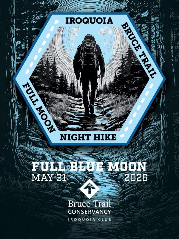
Full Moon Hike - Hendrie After Dark
https://hikes.brucetrail.org/event/full-moon-hike-hendrie-after-dark-2/Sorry, the registration cut-off time for this hike has been reached.Not a member? Click here to join today!Hosting Club: Iroquoia
Category: Moonlight Hikes
Location (Google Maps): RBG Centre Parking – across from Easterbrook’s 694 Spring Garden RoadHike Leader(s): Kathrin Koenig Click here to contact Hike Leader(s)
Pace: Medium – 3 to 4 km/hr
Terrain: Moderate – Some hills and/or some poor footing
Distance: Approx 6 kmDescription
Please be at parking by 8:00 pm as the hike will leave promptly at 8:15 pm.The Full Blue Moon is the sixth full moon of 2026. Please dress appropriately for the weather. Bring enough water and snacks to suit your needs, and a headlamp or flashlight. Headlamps with a red or green light setting are the most wildlife friendly, and best for preserving your night vision. Please ensure your device is fully charged/fresh batteries to last the duration of the hike.
We will start by following the outer road at Woodland Cemetery and pick up Grindstone Marsh Trail at Sunfish Pond. Following Grindstone Marsh Trail into Hendrie Valley, we will loop our way along the North and South Bridle Trail to Cherry Hill Gate and back to the cars. There is a set of stairs, one steep-ish downhill section, and a couple of smaller hills.
Please leave dogs at home.
This hike will qualify you for the new Iroquoia Full Moon badge! Complete three leader led-hikes in 2026, and you will qualify. Badges are $10 for BTC members/ $15 for non-members.
Any questions may be directed through “Click here to contact Hike Leader” on this form.
In the event you are no longer able to attend, please remove yourself from registration by following these steps:
– Sign into your account on the BTC website
– Click on My Hikes under your account
– This will take you to a list of hikes you have registered for
– Scroll down to the appropriate hike and cursor over to the far right hand column under the Action column.
– Click Cancel under the hike you wish to cancel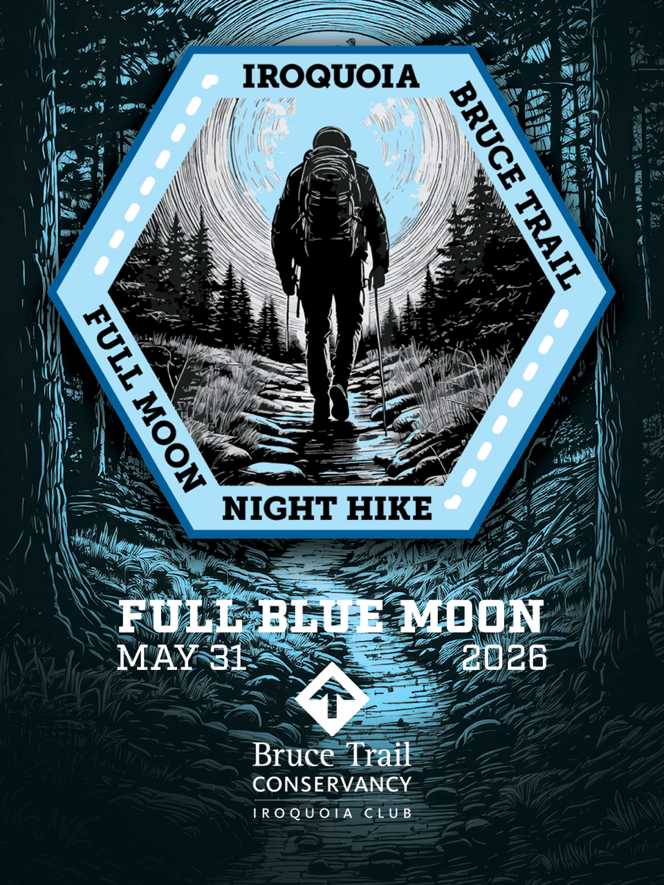
Moonlight Hike - Meet time is 8:15pm
https://hikes.brucetrail.org/event/moonlight-hike-2/Sorry, the registration cut-off time for this hike has been reached.Not a member? Click here to join today!Hosting Club: Iroquoia
Category: Moonlight Hikes
Location (Google Maps): Parking lot off of Ridge Rd located east of the southernmost portion of Beamer’s Side Trail which is now main trail.
Please park close together. If this lot is full, there are a few more spots a little further west on Ridge Rd. Roadside parking may also be possible.Hike Leader(s): Ruth Moffatt Click here to contact Hike Leader(s)
Pace: Medium – 3 to 4 km/hr
Terrain: Dependent on Conditions, Moderate – Some hills and/or some poor footing, Strenuous – Hilly with steep climbs and some poor footing
Distance: 4kmDescription
Earn your Iroquoia Moonlight badge by hiking 3 Moonlight Hikes with a leader.
Tonight’s sunset is at 8:50pm. We will follow the main trail past Beamer’s Falls around to the Hawkwatch area then the Grimsby Point Side Trail to form a loop back to the parking area onRidge Rd
If you’ve never hiked at night we are sure you will love the way it heightens all of your senses promising a great sleep afterwards.
Everyone must have a headlamp or a flashlight 🔦. Most phones have torches which could also be used as supplemental light. Please ensure your light device is fully charged/batteries to last about 1.5hours. Dress for the weather and bring enough water to suit your needs as well as all the other things you need for a hike – first aid kit, snack, poles (recommended).
This is the third of 3 full moon hikes to be held in Grimsby. After you complete three leader-led hikes, you will qualify for a badge. $10members/$15nin-members. Badges will be on hand – please bring cash.Any questions may be directed through contact on this form.
If you cannot make it, please remove yourself from registration by following these steps:To cancel your registration, here is a step by step:
– Sign into your account on the BTC website
– Click on My Hikes under your account
– This will take you to a list of hikes you have registered for
– Scroll down to the appropriate hike and cursor over to the far right hand column under the Action column.
– Click Cancel under the hike you wish to cancel - 01June 1, 2026
EASY DOES IT HIKE Glenridge Quarry Naturalization Hike
https://hikes.brucetrail.org/event/easy-does-it-hike-glenridge-quarry-naturalization-hike/Sorry, the registration cut-off time for this hike has been reached.Not a member? Click here to join today!Hosting Club: Niagara
Category: Leisurely
Location (Google Maps): Sir Isaac Brock WayHike Leader(s): Diane Marlatt Click here to contact Hike Leader(s)
Pace: Leisurely <3 km/hr
Terrain: Easy: mostly flat, good footing
Distance: 3 KmDescription

NEW Black Bear Badge Peninsula End2End - Hikes 1-5 of 8 hikes, June 1-5 (Hikes 6-8 of 8 July 27-29)
https://hikes.brucetrail.org/event/new-black-bear-badge-peninsula-end2end-hikes-1-5-of-8-hikes-june-1-5-hikes-6-8-of-8-july-27-29/Sorry, the registration cut-off time for this hike has been reached.Not a member? Click here to join today!This is a Multi-Day Hike
You are signing up for the following dates and times:
2026-06-01 at 12:00
2026-06-02 at 07:30
2026-06-03 at 07:30
2026-06-04 at 07:30
2026-06-05 at 07:30Hosting Club: Iroquoia, Peninsula
Category: General Hike
Location (Google Maps): Bluewater Park, WiartonHike Leader(s): Steven White Click here to contact Hike Leader(s)
Pace: Brisk – 4 to 5 km/hr
Terrain: Dependent on Conditions, Moderate – Some hills and/or some poor footing, Strenuous – Hilly with steep climbs and some poor footing
Distance: 13.3kmsDescription
Hike Peninsula in 8 hikes this summer and earn the New Black Bear Fundraising Badge!! June 1-5 and July 27-29, 2026. Separate registrations of June 1-5 and July 27-29. We will meet at 12 noon at Bluewater Park in Wiarton and shuttle to Crawford Drive Side Trail and hike back to Bluewater Park. June 2-5, we will be hiking the top part of the Peninsula. We will meet each morning at 7:30am and shuttle to the trail head. Shuttling at the beginning of the day and one shuttle at end of each day to take morning drivers back to their cars, will be shared among all hikers. These start times allow hikers to travel the morning of the hike and finish mid-afternoon. Any parking fees will be shared equally by all hikers. A full itinerary will be shared with hikers the week before our hikes begin. For those booking accommodation, recommend staying near the top part of the peninsula for June 1-5 and near Wiarton for the July dates.I expect to have the new Black Bear End to End Fundraising badges for our last hike July 29, to be distributed to those who completed all 8 hikes.
Hikers should bring layered clothing in case of cool, breezy or rainy days. Hikers should have hiking shoes/boots, poles, hat, raingear, sunblock, bug repellant, 2-3 litres of water and snacks/lunch. We will have 2 scheduled breaks each day, except for June1 (1 break) as it is a shorter hike. Anticipate 4 km/hr average pace including breaks, so please be honest with respect to your capability.
- 02June 2, 2026
Long Haulers Hike NEW TIME NEW LOCATION
https://hikes.brucetrail.org/event/long-haulers-hike-new-time-new-location-3/Sorry, the registration cut-off time for this hike has been reached.Not a member? Click here to join today!Hosting Club: Niagara
Location (Google Maps): Short Hills Wiley Road, Thorold
Pace: Fast 5+ km/hr
Terrain: Moderate: some hills and some poor footing
: 10k+Description
Back to our regular Spot for the Tuesday Long Hike. Note the new location. We will hike the trails around Short Hills Dress for the weather and bring sunscreen bug spray, poles snack and drinkScotsdale Farm and Indigenous Village, Forest Bathing
https://hikes.brucetrail.org/event/scotsdale-farm-and-indigenous-village-forest-bathing-2/Sorry, the registration cut-off time for this hike has been reached.Not a member? Click here to join today!Hosting Club: Dufferin Hi-Land
Category: Tuesday Hike
Location (Google Maps):Toronto Section, Map 13. Meet at Scotsdale Farm parking lot off of Trafalgar Rd (north of Km 29.8)
Hike Leader(s): Janice McClelland;Les Babbage Click here to contact Hike Leader(s)
Pace: Leisurely
Terrain: Moderate
Distance: Long Hike: 7 km, Short Hike: 5.8 kmDescription
We will quietly hike the Bennet Heritage Trail, crossing Snows Creek pond and then Owl Creek, close to the site of the an Indigenous (Attiwonderonk) village from 1550-80. We will share info about the village. Our hike follows Owl Creek with a scenic break spot. Long hike will return via the Maureen Smith Side Trail and then the Main Trail – the short hike will return directly to the parking lot via the Bennet Side Trail. Please bring water and a lunch.9:15 Short hike - Short Hills Park, Pelham Road
https://hikes.brucetrail.org/event/915-short-hike-short-hills-park-pelham-road-2/Sorry, the registration cut-off time for this hike has been reached.Not a member? Click here to join today!Hosting Club: Niagara
Category: Loop
Location (Google Maps): Short Hills Provincial Park, Pelham Road entranceHike Leader(s): janet davey Click here to contact Hike Leader(s)
Pace: Medium 3- 4 km/hr
Terrain: Moderate: some hills and some poor footing
Distance: 6 kmsDescription
Hike the main and side trails of Short Hills Provincial Park. Please bring water and hiking poles. Ticks are active so please check yourself for them after the hike.Urban Walk: Valley View Park
https://hikes.brucetrail.org/event/urban-walk-valley-view-park-thornhill-173/Sorry, the registration cut-off time for this hike has been reached.Not a member? Click here to join today!Hosting Club: Toronto
Location (Google Maps): Parking lot is off Sycamore Drive, East of Bayview , across Starbucks plaza
Bus 91 from Finch East station stops at Sycamore station.Hike Leader(s): MOHAMMAD AGHAMIRI Click here to contact Hike Leader(s)
Pace: Moderate (3-4 km/hr)
Terrain: Hilly, Level 2 (Intermediate – some hills and uneven surfaces, rocks and roots underfoot)
Distance (km): 6-7 kmDescription
We will explore Valleyview and Maple View parks, and walk along German Mill Creak, in return we stop in Huntington park and have snack under beautiful shed.Although this is considered an “Urban Walk”, you can expect some hills up and down and uneven surfaces with tree roots. Please bring hiking poles, Ice cleats water and snacks.
Tuesday Trekkers- Dufferin (km19.4-36.8) 2of 3
https://hikes.brucetrail.org/event/dufferin-km19-4-36-8-2of-3/Sorry, the registration cut-off time for this hike has been reached.Not a member? Click here to join today!Hosting Club: Beaver Valley
Location (Google Maps): Meet in the BT parking lot located off of 15 Sideroad, 50m west of the stop sign at the intersection of Prince of Whales and 15th Sideroad. km 36.8 Map 20 Ed 31
We will shuttle to Roadside parking on 1st Line (km19.4)Hike Leader(s): Kristina Rettie Click here to contact the hike leader.
Pace: Brisk, Medium
Terrain: Moderate, Some rocky footing, Some steep sections, Strenuous
Length of Hike: 17.5kmDescription
This Dufferin E2E will take place over 3 Tuesdays. Come out for all of them and earn you Dufferin E2E badge (you can apply for this independenly) or just come to the ones that interest you. We will start at km 0 and make our way north to km 55.5 covering the entire Dufferin section.This will be a car shuttle hike so please come with your car passenger ready. We will all take turns being the shuttle driver.
This time of year we can expect all types of trail conditions. Please be prepared with for the condition of the day.
Bring water lunch and a snack
Please no dogs

Boots and Books - The Iroquoia Bruce Trail Book Club Meet time is 10:30am
https://hikes.brucetrail.org/event/boots-and-books-the-iroquoia-bruce-trail-book-club-4/Sorry, the registration cut-off time for this hike has been reached.Not a member? Click here to join today!Hosting Club: Iroquoia
Category: Boots and Books – The Iroquoia Bruce Trail Book Club
Location (Google Maps): Kilbride Park Parking Lot behind the Kilbride SchoolHike Leader(s): Ruth Moffatt Click here to contact Hike Leader(s)
Pace: Medium – 3 to 4 km/hr
Terrain: Moderate – Some hills and/or some poor footing, Strenuous – Hilly with steep climbs and some poor footing
Distance: Approx 7kmDescription
Welcome to the 3rd Iroquoia Bruce Trail Book Club – “Boots and Books”Our book is “Theo of Golden” by Allen Levi. Please check your local library for available copies of this book.
We will hike from the parking lot north bound to Calcium Pits/Twiss Rd and return – about 7km which will take about 2 hours approximately. Please wear suitable foot wear, dress for the weather and bring poles if you use them and gaiters as the trail may be muddy. Please bring enough snacks and water suitable for the length/duration of the hike. It is not necessary to bring the book.
The June book will be “A History of Canada in 10 Maps” by Adam Shoalts and the July book will be “Woman, Watching” by Merilyn Simonds It may be a good idea to reserve these books now from your local library.
The hike is open to everyone whether you have read the book or not but there may he spoilers, if you haven’t read it. It will be open to 10 people to keep it more intimate for discussing the book.
If your plans change, please cancel your registration so that people who are waitlisted may join.
To cancel your registration, here is a step by step:
– Sign into your account on the Bruce Trail website.
– Go to the Hike Schedule
– Click on My Hikes tab which you should find at the top of the schedule
– Scroll to the appropriate hike you wish to cancel
– Cursor to the far right of the hike to the Action column
– Click cancel under the hike you wish to cancel.Walk In Nature Series (WINS) Tuesday Summer Evenings - Sydenham Forest
https://hikes.brucetrail.org/event/walk-in-nature-series-wins-sydenham-forest/Sorry, the registration cut-off time for this hike has been reached.Not a member? Click here to join today!Hosting Club: Sydenham
Category: General Hike
Location (Google Maps): Click the Google Maps link to take you there. Meet and park roadside at the corner of 6th Concession North and Sideroad 22 in the former Sydenham township just east of the Owen Sound airport. In the Bruce Trail Reference, Edition 31, meet at km 67.8 on Map 31.Hike Leader(s): Stewart Brown Click here to contact Hike Leader(s)
Pace: Medium: 3 to 4 km/h
Terrain: Moderate: Some hills and/or poor footing
Distance: 4 kmDescription
Tuesday evening WINS hikes begin at 6:30 p.m. as a way to enjoy the daylight and nice weather of summer evenings. Join us on this evening hike in the Sydenham Forest and the beauty of the escarpment nestled in the countryside close to Owen Sound. We will walk a 3 km loop which includes beautiful forest and escarpment edge then return 1 km on a quiet country road to our vehicles. We will also view the recent tree plantings that our Sydenham Biodiversity volunteer team has done on the Bruce Trail Conservancy (BTC) Protected Property, Sydenham Escarpment Nature Reserve. - 03June 3, 2026
Hidden Valley Park to Cityview Park
https://hikes.brucetrail.org/event/hidden-valley-park-to-cityview-park/Sorry, the registration cut-off time for this hike has been reached.Not a member? Click here to join today!Hosting Club: Iroquoia
Category: General Hike
Location (Google Maps): Meeting at the South parking lot of City View Park, Burlington (on Kerns Rd off of Hwy #5) where we will shuttle to Hidden Valley Park, Burlington (parking lot beside the HVP washrooms and just south of the Burlington Model Railway Club Inc) to begin our hike. Drivers for the shuttle will be needed as well as someone to return the drivers to retrieve their cars at the end of the hike. Thank you!Hike Leader(s): Karen Capindale-Smith Click here to contact Hike Leader(s)
Pace: Medium – 3 to 4 km/hr
Terrain: Strenuous – Hilly with steep climbs and some poor footing
Distance: 10+kmDescription
We will begin our hike on Hidden Valley Rd which goes thru the quaint village of Lemonville. Following Grindstone Creek past the village and into the woods we will connect with the main Bruce Trail. We will make the steep climb out of Sleepy Hollow and continue east along the BT to our original meeting spot at City View Park.Please remember to dress in appropriate layers and bring water and snacks.
Baked good should be expected 🙂
9:30 am Hike & Picnic
https://hikes.brucetrail.org/event/930-am-hike-picnic-2/Sorry, the registration cut-off time for this hike has been reached.Not a member? Click here to join today!Hosting Club: Niagara
Category: Loop
Location (Google Maps):Locust Grove Picnic Area
Hike Leader(s): Marion Hanover Click here to contact Hike Leader(s)
Pace: Medium 3- 4 km/hr
Terrain: Moderate: some hills and some poor footing
Distance: 7 kmDescription
Hike around Queenston area. Optional outdoor gathering in Locust Grove including pot luck picnic after the hike.Art and Tree Trail Hike
https://hikes.brucetrail.org/event/art-and-tree-trail-hike/Sorry, the registration cut-off time for this hike has been reached.Not a member? Click here to join today!Hosting Club: Blue Mountains
Category: Organized Hike
Location (Google Maps): Duntroon Highlands Resort, 1226 North, Nottawasaga Concession 10, ClearviewHike Leader(s): Linda Finley Click here to contact Hike Leader(s)
Pace: Leisurely – 3 km/hr. or less
Terrain: Easy – Mostly flat and usually good footing
Distance: 2 km loopDescription
Come and join a small group for a leisurely summer hike on the unique “Art and Tree Trail” located on Duntroon Highlands Resort property. It was created by the not-for-profit HealthWithNature.orgThe 2 km loop meanders through open fields and wooded areas. It has several spots where one can pause and reflect on outdoor installations and features designed by local artists.
You will come away feeling inspired and revitalized.
A fee of $10 is to be paid at the start of the hike. This goes towards paying the artists and maintaining the trail. Meet at Duntroon Highlands.
For those that have time to socialize after the hike, food and refreshments are available at the on-site Clubhouse Cafe.
WEDNESDAY WALKERS - East of Kolapore
https://hikes.brucetrail.org/event/wednesday-walkers-east-of-kolapore-4/Sorry, the registration cut-off time for this hike has been reached.Not a member? Click here to join today!Hosting Club: Beaver Valley
Location (Google Maps): Park in the Kolapore parking lot, near Km 23.5, Map 25, Edition 31, for a car shuttle to the start of our hike.
Hike Leader(s): Margaret Yaraskavitch Click here to contact the hike leader.
Pace: Medium
Terrain: Moderate
Length of Hike: 4.7 kms + 650 m of roadDescription
We will walk south from 12th Sideroad and as we walk through deciduous forest, we’ll cross a piece of history, remnants of The Old Mail Road. We continue south, crossing Grey Road 19, through property that is managed by the BTC, until we return to our cars. Please bring water.
Harrison Park Loop
https://hikes.brucetrail.org/event/harrison-park-loop-3/Sorry, the registration cut-off time for this hike has been reached.Not a member? Click here to join today!Hosting Club: Sydenham
Category: General Hike
Location (Google Maps): Harrison Park – northwest of km 89.0 BTC MAP #32. Drive past restaurant.Hike Leader(s): Ian Mills
Pace: Medium: 3 to 4 km/h
Terrain: Moderate: Some hills and/or poor footing, There might be muddy sections., There might be sections with water on the trail.
Distance: 10 kmDescription
We will meet at Harrison Park just past the restaurant (east) and follow Harrison Park Side Trail north to the Main Trail. We will follow the Main Trail south to Inglis Falls pack a light snack and enjoy some amazing views of the Falls. We will follow the Main Trail north to Creamery Side Trail and circle back to our parking area. Interesting terrain , lovely views and good exercise will be provided by this loop – BTC MAP #32. A walking stick is recommended and proper footwear required.Good Companions Dundas Valley Loops
https://hikes.brucetrail.org/event/good-companions-dundas-valley-loops/Sorry, the registration cut-off time for this hike has been reached.Not a member? Click here to join today!Hosting Club: Iroquoia
Category: Good Companions
Location (Google Maps): Trail Centre for the Dundas Valley Conservation area, off Governors Road in Dundas.Hike Leader(s): Janina Vanderpost Click here to contact Hike Leader(s)
Pace: Medium – 3 to 4 km/hr
Terrain: Moderate – Some hills and/or some poor footing
Distance: 9kmDescription
Meeting at 9:45 am at the Dundas Valley Conservation area Trail Centre. Note that a Hamilton Conservation Authority pass or payment at the gate on Governors Road required. Starting at 10 am we will hike some loops involving the Sawmill Trail, Spring Creek Trail, Sulphur Creek Trail and a portion of the main loop.Bring water, snack, hiking poles if using, hiking boots and possibly bug spray. There may be a bit of mud but the trails overall should be in good condition. Some hilly sections.
Power walk along the Humber River Trail & and optional visit to the McMichael Canadian Art Collection
https://hikes.brucetrail.org/event/power-walk-along-the-humber-river-trail-ca-10-km-and-optional-visit-of-the-mcmichael-canadian-art-collection-kleinburg-2/Sorry, the registration cut-off time for this hike has been reached.Not a member? Click here to join today!Hosting Club: Toronto
Category: Car Hike
Location (Google Maps): McMichael Canadian Art Collection, Humber TrailHike Leader(s): Natalia Svechnikova Click here to contact Hike Leader(s)
Pace: Brisk (4-5 km/hr)
Distance (km): 10-11 km
Description
Please join me for a brisk walk on the Humber River trail strting near the McMichael Canadian Art Collection (main building).The trail has some hills but it is even and easy to walk on. we will walk for about 5 – 5.5 km and return back the same way. It should take us about 2.5 – 3 hours. After we finish, you can spend some time in the gallery and see their newest exhibition”Morrice in Venice” (please check out their website for ore info https://mcmichael.com/upcoming-exhibitions/)
We meet around 10 am near the entrance to the gallery and start hiking at 10:15 am (the trail head is only 50 m away). If you have the McMichael Art Collection membership, you can park free of charge on the gallery’s parking lot. Non-members parking fee is about $7. You can park somewhere in Kleinburg free of charge and walk to the gallery to meet me.
Please be dressed for the weather and wear comfortable shoes. Please bring 2 L of water, rain jacket or umbella and your sun hat, sun galsses. There is no shade on the trail.
You are welcome to reach out if you have any questions.
Please note that the hike will be cancelled if there is a forecast for a heavy rain or storm.
Evening Hike in Owen Sound followed by an Opportunity for Refreshments
https://hikes.brucetrail.org/event/evening-hike-in-owen-sound-followed-by-an-opportunity-for-refreshments-22/Sorry, the registration cut-off time for this hike has been reached.Not a member? Click here to join today!Hosting Club: Sydenham
Category: An evening walk.
Location (Google Maps): Meet in the municipal parking lot by the river on the West side of 1st Ave East between 7th St East and 8th St East in Owen Sound.Hike Leader(s): Harriet Nixon Click here to contact Hike Leader(s)
Pace: Brisk: 4 to 5 km/h
Terrain: Moderate: Some hills and/or poor footing
Distance: Approx 5 kmDescription
Join us for a brisk evening hike exploring paths and neighbourhoods in Owen Sound, followed by an opportunity for refreshments. There is no need to show up 15 minutes early for this hike, but we will leave promptly at 7:00 pm. - 04June 4, 2026
NEW TIME 8:00 Long Hike, Glen Road Jordan
https://hikes.brucetrail.org/event/new-time-800-long-hike-glen-road-jordan-3/Sorry, the registration cut-off time for this hike has been reached.Not a member? Click here to join today!Hosting Club: Niagara
Location (Google Maps):
3640 Glen Road Jordan
Pace: Fast 5+ km/hr
Terrain: Strenuous: hilly, with steep climbs, poor footing
: 10 kmDescription
Hike in and around Ball’s Falls and Jordan. Dress for the weather: bring bug spray, sunscreen drink and poles.Hiking around Jordan
https://hikes.brucetrail.org/event/hiking-around-jordan-57/Sorry, the registration cut-off time for this hike has been reached.Not a member? Click here to join today!Hosting Club: Niagara
Category: Hike
Location (Google Maps): Sho’arishon Park (Jordan Hollow)Hike Leader(s): Bill Russell Click here to contact Hike Leader(s)
Pace: Medium 3- 4 km/hr
Terrain: Moderate: some hills and some poor footing
Distance: 7 kmDescription
Hiking in and around Jordan, Jim Rainforth Trail and Balls Falls (alternating every 3 weeks)Urban Walk: Valley View Park
https://hikes.brucetrail.org/event/urban-walk-valley-view-park-thornhill-174/Sorry, the registration cut-off time for this hike has been reached.Not a member? Click here to join today!Hosting Club: Toronto
Location (Google Maps): Parking lot is off Sycamore Drive, East of Bayview , across Starbucks plaza
Bus 91 from Finch East station stops at Sycamore station.Hike Leader(s): MOHAMMAD AGHAMIRI Click here to contact Hike Leader(s)
Pace: Moderate (3-4 km/hr)
Terrain: Hilly, Level 2 (Intermediate – some hills and uneven surfaces, rocks and roots underfoot)
Distance (km): 6-7 kmDescription
We will explore Valleyview and Maple View parks, and walk along German Mill Creak, in return we stop in Huntington park and have snack under beautiful shed.Although this is considered an “Urban Walk”, you can expect some hills up and down and uneven surfaces with tree roots. Please bring hiking poles, Ice cleats water and snacks.
Halton Forest to Speyside (E2E)
https://hikes.brucetrail.org/event/halton-forest-to-speyside-e2e-4/Sorry, the registration cut-off time for this hike has been reached.Not a member? Click here to join today!Hosting Club: Iroquoia
Category: General Hike
Location (Google Maps): Meet at the Pear Tree parking lot at Speyside on 15 Side Road at 9:15 am.Hike Leader(s): Karen Bergmann Click here to contact Hike Leader(s)
Pace: Medium – 3 to 4 km/hr
Terrain: Moderate – Some hills and/or some poor footing
Distance: 8 kmsDescription
We will meet at 9:15 in the Pear Tree parking lot on 15 Side Road and carpool to 6th Line at the Halton Agreement Forest and hike back along the Hilton Falls Side Trail, Al Shaw Side Trail and the main trail. This trail has some serious rocks and we cross a couple of creeks. Bring sufficient water and bug spray/bug net.
12:30 p.m. Pack Walk
https://hikes.brucetrail.org/event/130-p-m-pack-walk-4/Sorry, the registration cut-off time for this hike has been reached.Not a member? Click here to join today!Hosting Club: Niagara
Category: In and Out
Location (Google Maps): Merritt Island Park, Welland Canal Trail, Welland, ON – parking lot 8 Merritt Island BuildingHike Leader(s): Sam Rutherford Click here to contact Hike Leader(s)
Pace: Leisurely <3 km/hr
Terrain: Easy: mostly flat, good footing
Distance: 5 kmsDescription
This pack walk is a structured group walk where dogs and their handlers walk together on-lead in a natural environment. It promotes exercise, calm socialization and exposure to other dogs and people in a safe, controlled setting. We will meet at the Merritt Island Building and follow the Welland Canal Trail out to Woodlawn Road and loop back. Dogs must be kept on-lead and under control at all times. Please bring water and treats for you and your dog.
Cancelled: Toronto Islands Walk
https://hikes.brucetrail.org/event/urban-walk-toronto-islands-evening-walk-23/Sorry, the registration cut-off time for this hike has been reached.Not a member? Click here to join today!Hosting Club: Toronto
Location (Google Maps):
Jack Layton Ferry Terminal, by the gate to the Wards Island Ferry. Please arrive 20 minutes prior to departure to check in with hike leader.
From Union Station take the LRT and get off at the stop Ferry Docks.Walk up to the Ferry Docks on Queens Quay West, street level. at the foot of Bay Street.
Hike Leader(s): Tom Swales Click here to contact Hike Leader(s)
Pace: Leisurely (2-3 km/hr)
Terrain: Flat, Level 1 (Easy – mostly on flat, well maintained trails with hard-packed surface)
Distance (km): 6-9 kmDescription
*** The Thursday June 4th Toronto Island evening hike has been cancelled. There will be evening hikes on May 21st and May 28th, no hike on June 4th, and then resuming the rest of the Thursday evenings in June. from June 11th – June 25th **After a day’s work come and “cool off” on the Toronto Islands free of fumes and traffic. Enjoy the view of the city skyline and Toronto’s beautiful island parkland.
Pack a dinner for a sit down picnic. Also bring a warm jacket and flashlight.
Return fare ticket for the ferry is $9.57 for adults, $6.15 for seniors
Please check the hike schedule for weather related cancellations (hike will be updated by 11:00 AM day of the hike if any changes)
Toronto Island evening hikes will take place every Thursday in May and June 2026.
Same time and same meeting place. No preregistration is required – just show up at the ferry docks at 5:40 PM and sign in with the hike leader. - 05June 5, 2026
9:00 am Niagara on the Lake Tour & Some Yoga
https://hikes.brucetrail.org/event/900-am-niagara-on-the-lake-tour-some-yoga-23/Sorry, the registration cut-off time for this hike has been reached.Not a member? Click here to join today!Hike open to BTC Members only.
Hosting Club: Niagara
Category: Urban
Location (Google Maps):Veteran’s Memorial Park, park just outside the park on King St.
Hike Leader(s): Robin Garrett Click here to contact Hike Leader(s)
Pace: Leisurely <3 km/hr
Distance: 6 km
Description
Enjoy the benefits of pausing for a yoga practice as we tour through the trails, parkland and Historic Niagara-on-the-Lake. No mat required. Movement will focus on a flow of standing poses designed especially for hikers. Plan to stay for conversation and a warm cup of coffee or tea at Sweets & Swirls, Community Centre, Niagara Stone Road, NOTL.Peninsula Wildflower Hike Series
https://hikes.brucetrail.org/event/peninsula-wildflower-hike-series-2/Sorry, the registration cut-off time for this hike has been reached.Not a member? Click here to join today!Hike open to BTC Members only.
Hosting Club: Dufferin Hi-Land
Category: Special Events
Location (Google Maps): Northeast corner of Highway 6 and Dyer’s Bay Road, south of Tobermory.Hike Leader(s): Stuart Law; Anne Armstrong; Jeannine Kralt. Click here to contact Hike Leader(s)
Pace: Leisurely
Terrain: Dependent on Conditions, Moderate, Slippery Sections Likely
Distance: 3-6 kms a dayDescription
Join us on a three-day odyssey to find the floral treasures of the Peninsula on Flowerpot Island, the Crane River, Singing Sands, the Oliphant Fens, Petrel Point and the Bruce Alvar. A chance to work on your Peninsula Orchid badges if you are a badge person. These hikes, led by longtime BTC wildflower enthusiasts Anne Armstrong and Jeannine Kralt, are a co-operative effort brought to you by the Peninsula, Iroquoia and Dufferin Hi-Lands BTC Clubs. We look forward to enjoying the camaraderie and fellowship of staying at the same accommodations and sharing a few laughs at dinners. Please bring your own breakfasts and lunches. Discount accommodation/boat package information will be made available on registration. The accommodation/boat package discount pricing will be available until May 4, 2026. Hikers to pay for the accommodation/boat package themselves direct. Please note the $20.00 fee payable on registration is non-refundable. An additional and separate $20.00 contribution per hiker for gas and mileage will also be required. - 06June 6, 2026
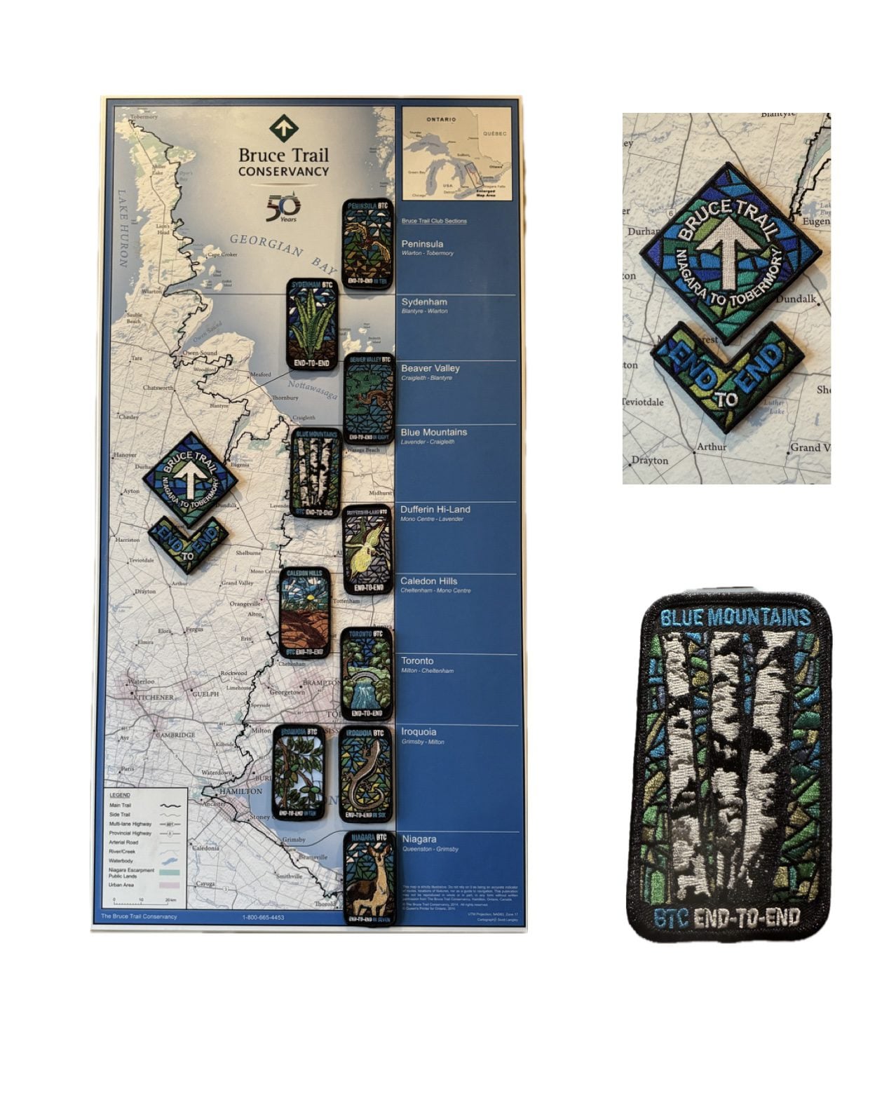
Blue Mountains End to End Fundraiser for the Stained Glass Badge June 6,7,8, 2026
https://hikes.brucetrail.org/event/blue-mountains-end-to-end-fundraiser-for-the-stained-glass-badge-june-678-2026/Sorry, the registration cut-off time for this hike has been reached.Not a member? Click here to join today!This is a Multi-Day Hike
You are signing up for the following dates and times:
2026-06-06 at 07:30
2026-06-07 at
2026-06-08 atHosting Club: Iroquoia, Blue Mountains
Category: Stained Glass Badge End to End Fundraiser Hike
Location (Google Maps): Registered participants will receive a WhatsApp invitation (optional)which can be used for photo share and other pertinent information.This is a three day fundraiser ETE for the stained glass badge. You must be able to hike at least 4km an hour with hills and rough terrain.
June 6 – Day 1 – Meet in the parking lot parking lot area located 380 m north of the main trail crossing Pretty River Road (40 car capacity) 44.430927, -80.275390 Shuttle to Maple Lane in Ravenna. Park only on the north side 44.504973, -80.331780 (4 car capacity) 20km
June 7 – Day 2 – Meet in the parking lot parking lot area located 380 m north of the main trail crossing Pretty River Road (40 car capacity) 44.430927, -80.275390 Shuttle to $paid parking lot off of 15/16 Sideroad – accessible only from Concession 10 South. 44.342784, -80.210628 (car capacity 7) 24km
June 8 Day 3 – Meet in front of the Lavender Cemetery on Mulmar Nottawasaga Townline 550 meters east of Lavender Hill Road – do not block cemetery gate. 44.268777, -80.156810 (Car capacity 10) and shuttle to $paid parking lot on 15/16 Sideroad 44.342784, -80.210628 (Car capacity 7) 22.50km.Parking fees are shared by everyone except the drivers.
Hike Leader(s): Ruth Moffatt Click here to contact Hike Leader(s)
Pace: Brisk – 4 to 5 km/hr
Terrain: Moderate – Some hills and/or some poor footing, Slippery and Steep Sections, Strenuous – Hilly with steep climbs and some poor footing
Distance: 67.50km spread over three daysDescription
Everyone who is registered for this hike series will be invited to join an optional WhatsApp which can be used to share photos and other information.Distances will be spread over 3 days as equally as possible depending on the parking. Please bring enough food and snacks for a 20km + day of hiking and 2l of water minimum.
Everyone must have a first aid kit in their backpack as well as all the other items you require for a long day hike (poles, rain gear etc)
The registration fee includes the badge, guidance and organization. The fee supports the club’s infrastructure and the mission of “Preserving a ribbon of wilderness for everyone, forever.” There are no refunds.This series of hikes is intended for hikers who are used to a multi-day distance of 20+km at a steady pace. We will have a short break around 10am and a lunch break. Afternoon break is dependent on expected finishing time. Please do not over estimate your hiking ability.
Participants can make up one of the three days on their own if you have a scheduling conflict. Please try to do this before we get started.
You must be willing to share in the car shuttle to the start of the hike or driving the drivers back at the end of the day. Please have a minimum 4 useable seats including driver’s. This is a group hike and it is intended that everyone be present on each day.
Please cancel your registration if your plans change so that someone else who may be on the waitlist can take your place. Paid parking on two days to be shared by non-drivers.All registered hikers will be invited to join a WhatsApp group. This can be used for sharing photos and other items of interest.
Refunds: https://brucetrail.org/paid-hike-refund-policy/
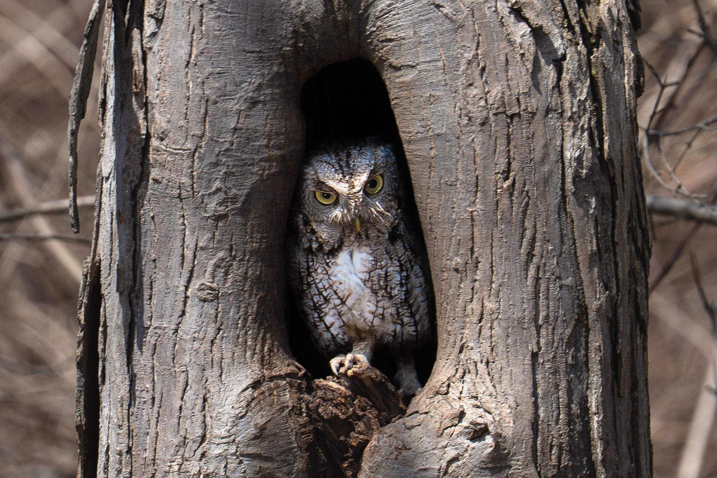
RAINBOW HIKE: Birding with Pride
https://hikes.brucetrail.org/event/rainbow-hike-birding-with-pride/Sorry, the registration cut-off time for this hike has been reached.Not a member? Click here to join today!Hosting Club: Iroquoia
Category: Rainbow Hike
Location (Google Maps): Royal Botanical Gardens – Hendrie Valley Sanctuary, Cherry Hill GateHike Leader(s): Shayne Ward Click here to contact Hike Leader(s)
Pace: Leisurely – 3km/hr or less
Terrain: Easy – Mostly flat and usually good footing, Moderate – Some hills and/or some poor footing
Distance: 5KMDescription
Join us as we kick off Pride Month with a colourful morning of birding! 🦅🦉🦆🌈For this edition, it’s encouraged to come dressed in the colours of your favourite bird! 🌈
This gentle early-morning outing will explore the trails around Royal Botanical Gardens, one of our region’s important migration areas. We will start at the trailhead parking lot of the Cherry Hill Gate.
Plan to arrive for 745AM and we’ll have a small crash course on downloading and using two popular birding apps, Merlin Bird ID and eBird recording our sightings! We’ll depart by 8-810AM. Hoping to catch some Blue Herons, Swans, Wood Ducks, and if we’re lucky, a sighting of the RBG resident Screech Owl!
🌈 This is a queer-led, 2SLGBTQIA+ inclusive Rainbow Hike, welcoming LGBTQ+ hikers, allies, birders, photographers, and anyone interested in connecting with nature and community. This is a short, relaxed hike (approx. 5 km) designed to get us moving and birding!
What to Bring
• Water and light snacks
• Weather-appropriate clothing and sturdy footwear
• Binoculars or camera if you have them (optional but fun! And a cell phone counts!)Not a Bruce Trail member yet?! Sign up here!
https://brucetrail.org/become-a-member/Come enjoy a spring morning on the trail, celebrate migratory birds, and connect with your Bruce Trail community!
🐾 Please leave pets at home for this hike! It’s migration season and we’ll be passing through an important bird migration and nesting area, so we want to keep disturbance to our feathered friends to a minimum! 🐦
🚗 🚌 This outing is accessible by car or public transit.
Planning to drive?
Parking is 3$/hour to a maximum of 15$ if you park at Cherry Hill Gate, or free if you park across the street at RBG Centre.Taking the Bus?
HSR #9 or BT1 stops near the trailhead entrance! Map of the bus and it’s schedule can be found here.
https://www.hamilton.ca/sites/default/files/2026-04/hsr-9-ROCK%20GARDENS-may10.pdfFree Bruce Trail Rainbow badges and stickers for all participants!
Questions? Simply click “Contact Hike Leader” on the registration form.
CANCELLED: Petroglyphs Provincial Park
https://hikes.brucetrail.org/event/coach-trip-petroglyphs-provincial-park/Sorry, the registration cut-off time for this hike has been reached.Not a member? Click here to join today!Hosting Club: Toronto
Category: Cancelled
Location (Google Maps): Petroglyphs Provincial ParkHike Leader(s): Robin Crombie and Felix Wan Click here to contact Hike Leader(s)
Pace: Moderate (3-4 km/hr)
Terrain: Hilly, Level 2 (Intermediate – some hills and uneven surfaces, rocks and roots underfoot), Rocky, Variable
Distance (km): 8Description
This trip has been cancelled and will be rescheduled to a future date – June 6th is a holiday for Nishnaabeg and access to the site will be limitedIn recognition of June being National Indigenous History Month in Canada, join us for a visit to Petroglyphs Provincial Park.
The day will be divided into two portions. We’ll begin by touring the exhibits and watching a 20-minute video at the Learning Place Visitor Centre to discover the traditions of the Ojibway (Nishnaabe) people, which will be followed by a 45-minute guided tour of the Kinoomaage Waapkong (aka The Teaching Rocks or the Peterborough Petroglyphs), the largest known concentration of Indigenous rock carvings (petroglyphs) in Canada. Afterwards, we will hike along the Nanabush Trail, stopping near Minnow Lake for a lunch break, then continue our hike along the Marsh and West Day Use Trails.
Although the total hiking distance is short (approximately 8 km), the trails are in the heart of the Canadian Shield and are rugged. There are rocks and roots, and some hilly stretches. Bring hiking boots and poles if you have them. Also bring a lunch and snacks, at least 2L of drinking water, rain/sun protection, and insect repellent.
If time permits, we will have a refreshment stop in the town of Lakefield.
Expect a late return to Toronto (approximately 7:00 p.m., traffic conditions permitting).
Car Hike: Glasgow Village
https://hikes.brucetrail.org/event/car-hike-glasgow-village-uxbridge-7/Sorry, the registration cut-off time for this hike has been reached.Not a member? Click here to join today!Hosting Club: Toronto
Location (Google Maps): Glasgow Trail, Concession Road 2
Park in parking lot at the head of trail
Hike Leader(s): MOHAMMAD AGHAMIRI Click here to contact Hike Leader(s)
Pace: Moderate (3-4 km/hr)
Terrain: Hilly, Level 2 (Intermediate – some hills and uneven surfaces, rocks and roots underfoot), Variable
Distance (km): 14-15 kmDescription
Lets explore Goodwood conservation area and visit Secord forest and pondSeven Rivers Hike Badge Series - Hike 2
https://hikes.brucetrail.org/event/seven-rivers-hike-badge-series-hike-2/Sorry, the registration cut-off time for this hike has been reached.Not a member? Click here to join today!Hosting Club: Dufferin Hi-Land
Category: General Hike
Location (Google Maps): Mad River Blue Mountains Section Map 22
Parking: lot off County Road 124, east of Singhampton and west of Devil’s Glen Country Club in front of the Devil’s Glen Provincial Park gates.Hike Leader(s): Tristan Goguen and Pat Foley Click here to contact Hike Leader(s)
Pace: Medium
Terrain: Moderate
Distance: 10.9KmDescription
Today we will hike from the parking lot to the viewing platform then return to the main trail walking southbound until we meet the Ganaraska Trail. We will hike along the Ganaraska trail until we come out on Concession Road 8 in Glen Huron. Just past station Street we will turn west and follow the Mad River Side Trail until we rejoin the main trail. From there we will hike back to the cars.Please be prepared for the weather, we will hike rain or shine. Ensure you have enough water,lunch and snacks, sunscreen and bug repellent. Hats and sunglasses are recommended as are poles and sturdy shoes.
For those wishing to earn their 7 Rivers – complete all 7 hikes, badges will be available on the last day from the hike leaders at a cost of $10 for members and $15 for non members.
Anyone completing make-up hikes may log their hikes and apply directly to the Dufferin Highlands BT Club for the badge.
9:00 am Walker Creek 5 4 3 2 1 Grounding Hike
https://hikes.brucetrail.org/event/900-am-walker-creek-5-4-3-2-1-grounding-hike/Sorry, the registration cut-off time for this hike has been reached.Not a member? Click here to join today!Hike open to BTC Members only.
Hosting Club: Niagara
Category: Mindfulness
Location (Google Maps):Welland Canal parking area at Lock 1 on Lakeshore Road
Hike Leader(s): Suzanne Gourluck Click here to contact Hike Leader(s)
Pace: Leisurely <3 km/hr
Terrain: Easy: mostly flat, good footing
Distance: 9 kmDescription
*This hike is one of our new MINDFULNESS seriesJoin me on this 5 4 3 2 1 grounding hike and learn a simple strategy for managing anxious racing thoughts. We will hike through Malcomson Eco Park along Sunshine beach, up Walker Creek and back, stopping a couple of times along the way to ground ourselves using the 5 4 3 2 1 technique.
*If the parking lot at the canal is full please park in Malcolmson Eco Park (accessed at the Niagara/Lakeshore intersection) and walk up to the canal.
Dr. Philip Gosling Memorial Hike & Founders’ Footpath Plaque Unveiling
https://hikes.brucetrail.org/event/dr-philip-gosling-memorial-hike-founders-footpath-plaque-unveiling/Sorry, the registration cut-off time for this hike has been reached.Not a member? Click here to join today!Hosting Club: Caledon Hills
Category: General
Location (Google Maps): Akela and Scouters Heather and Ross Hamlin Nature Reserve at Riverside Woods
713377 1st Line EHS, Mono
Google GPS Coordinates: 43.959916, -80.070494Driving Directions:
From ON-9, head north onto 2nd Line EHS for 3 kilometres. Turn left onto Side Road 5 for 1.5 kilometres. Turn right onto 1st Line EHS for approximately 1 kilometre. Continue straight into the parking lot.From ON-10, head east on Hockley Road/Dufferin County Road 7 for 1 kilometre. Continue straight onto Side Road 5 for 1.5 kilometres. Turn left onto 1st Line EHS for approximately 1 kilometre. Continue straight into the parking lot.
Hike Leader(s): Sandy Green Click here to contact Hike Leader(s)
Pace: Brisk – 4 to 5 km/hour, Leisurely – 3 km/hour or less
Terrain: Easy – mostly flat and usually good footing
Distance: 2 or 3 kilometresDescription
Bruce Trail members and friends are invited to gather in nature to honour the life, vision, and legacy of Dr. Philip Gosling, Founder of the Bruce Trail. A time of reflection and the unveiling of the Founders’ Footpath commemorative plaque will be led by Michael McDonald, CEO of the Bruce Trail Conservancy, followed by a guided walk along the footpath, and a time of fellowship and refreshments.
International Trails Day Hike - Cotswold Way
https://hikes.brucetrail.org/event/international-trails-day-hike-cotswold-way/Sorry, the registration cut-off time for this hike has been reached.Not a member? Click here to join today!Hosting Club: Peninsula
Location (Google Maps): BTC Parking Lot, #2461 Bruce County Rd. 9
Hike Leader(s): Marg and Owen Glendon Click here to contact Hike Leader(s)
Pace: Medium (3.0 – 4.5 km/h): A comfortable pace for most hikers with steady progress.
Terrain: Difficult: Steep ascents/descents, rocky scrambling, and some rugged escarpment paths., Moderate: Rolling hills, mild slopes and rocky paths.
Distance: ~6.5 kmDescription
Celebrate International Trails Day on June 6 with a hike that connects you to trails around the world.Step onto the Bruce Trail and discover the spirit of global adventure through the Friendship Trails program, an international network linking trail communities across countries. Like twin towns, these special partnerships bring people together through shared experiences, culture, and a love of the outdoors.
Bruce Trail Conservancy maintains 10 Friendship Trails at different locations along the Bruce Trail. The Peninsula Bruce Trail Club is proud to host two of these international connections: England’s Cotswold Way and South West Coastal Path. Learn more about BTC Friendship Trails here: https://brucetrail.org/International-friendship-trails/.
Kick off our three-part Friendship Hike series on the Cotswold Way Friendship Trail section with a scenic 6.5 km loop hike along the Main Trail and Beth Gilhespy Side Trail, near Barrow Bay. This moderately paced hike features rugged, rocky terrain, a few challenging climbs, and breathtaking views over Georgian Bay and Little Lake, perfect for sparking your next hike-travel dream. Plan on 2 1/2 – 3 hours which includes lots of time for photos and storytelling.
We are thrilled to have two knowledgeable guests join us for the hike! Jackie Randle, BTC Vice President of Operations and President of the World Trails Network, will share inspiring stories and insights about International Friendship Trails and the World Trails Network. Tom Hall, PBTC Trail Maintenance Director, and Friendship Trail Badge Earner, will also join us to share some of his hiking experiences along the Cotswold Way Trail.
Have you walked the Cotswold Way? Bring your stories and be part of the conversation.
Celebrate trails around the world and the healthy lifestyle that trails inspire!
Ample parking and onsite portapottie available.
Geology Hike #6B Inglis Falls loop
https://hikes.brucetrail.org/event/geology-hike-6b-inglis-falls-loop-2/Sorry, the registration cut-off time for this hike has been reached.Not a member? Click here to join today!Hosting Club: Sydenham
Category: Geology Hike
Location (Google Maps):Meet in the parking lot behind the Grey-Sauble Conservation Authority head office.
237897 Inglis Falls Road, Owen SoundHike Leader(s): Beth Gilhespy Click here to contact Hike Leader(s)
Pace: Leisurely: 3 km/h or less
Terrain: Moderate: Some hills and/or poor footing, Strenuous: Hilly with steep climbs and some poor footing., There might be muddy sections., There might be sections with water on the trail.
Distance: 5.5 km. approxDescription
This is part B of Geology Hike #6 (Inglis Falls loop) following Beth Gilhespy’s book “Walking Through Time” in the Sydenham Bruce Trail Section and BETH GILHESPY will be leading this hike ! This is a loop, starting from the parking lot at Grey Sauble Conservation Area parking lot behind the main building. We will hike in a southerly direction on the main trail towards Inglis Falls, cross the Inglis Falls Road and continue on main trail to join the Creamery Hill sidetrail and back to our cars.Copies of all of Beth’s books will be available for purchase. Special member’s only price of $37.00 . Cash or etransfer. If paying with cash, please bring exact change. Please bring water and a snack if you wish. Proper hiking footwear and hiking poles are recommended.
American Chestnut Tree Maintenance
https://hikes.brucetrail.org/event/american-chestnut-tree-maintenance/Sorry, the registration cut-off time for this hike has been reached.Not a member? Click here to join today!Hosting Club: Dufferin Hi-Land
Category: Special Events
Location (Google Maps): Bruce Trail Parking Lot on the 1st line EHike Leader(s): Cathy Hughes
Pace: Leisurely
Terrain: Easy
Distance: 3 kmDescription
In Fall 2024, approximately 90 American Chestnut trees were planted on the property. Be part of the ongoing monitoring and maintenance program. Volunteers will assist DHBTC Biodiversity Committee members and Bruce Trail Conservancy Ecologists with mulching and replacing tree guards. We will also be examining trees to help determine survival rates. Some invasive species removal may also occur.If time permits, a short hike of the area will occur.
Please bring water and gloves if you have them. It is recommended you dress according to the weather and wear sturdy boots or shoes and long pants as ticks are possible in the area. All other equipment will be provided.
Urban Walk - Don Valley to The Distillery District (29 KM)
https://hikes.brucetrail.org/event/urban-walk-don-valley-to-the-distillery-district-29-km/Sorry, the registration cut-off time for this hike has been reached.Not a member? Click here to join today!Hosting Club: Toronto
Category: Urban Walk
Location (Google Maps): East Don/Don RiverHike Leader(s): Brian Rideout Click here to contact Hike Leader(s)
Pace: Moderate (3-4 km/hr)
Terrain: Flat
Distance (km): 27.5 kmDescription
This hike follows the Don River south from Steeles Ave East at Leslie St through Toronto to the Distillery District, through a series of ravines and several parks. We will detour to street level when we cross the 401 (trail closed due to construction) and again south of Pottery Rd where we take the Bayview Ave Extension (trail closed due to construction). Those who register will receive an itinerary.Please bring a lunch and at least two liters of water. Be prepared for cool / wet weather. Pub stop after at The Spaghetti Factory, adds an extra 1.5 KM
Here is an online map of our route: Don Valley to The Distillery https://onthegomap.com/s/7og8khua
Here is the itinerary for the day.
10:00 AM
0
Steeles and Leslie11:45 AM
6
Sheppard and Leslie – east end of subway station at street level12:48 PM
9.6
Lesmill & York Mills Tim Horton’s)1:40 PM
12.6
Edwards Gardens (Lawrence and Leslie) – 15 minute lunch break max2:48 PM
15.6
Underpass of Eglinton, west of Leslie – in the parking lot east end near the bins3:06 PM
16.6
behind the Ontario Science Centre – we will not be leaving the path4:40 PM
22
Pottery Rd – at cross walk5:33 PM
25
Riverdale Park Crossing6:15 PM
27.5
Distillery District – TTC terminus6:45 PM
29
The Old Spaghetti FactoryCar Hike: Scotsdale Farm,Map 13
https://hikes.brucetrail.org/event/car-hike-scotsdale-farm-map-13/Sorry, the registration cut-off time for this hike has been reached.Not a member? Click here to join today!Hosting Club: Toronto
Category: Car Hike
Location (Google Maps):Scotsdale Farm, Map 13
Hike Leader(s): Al Brown Click here to contact Hike Leader(s)
Pace: Moderate (3-4 km/hr)
Terrain: Level 2 (Intermediate – some hills and uneven surfaces, rocks and roots underfoot), Variable
Distance (km): 13 kmDescription
Come join me for hike through Scotsdale Farm and the Silver Creek Conservation Area.We will complete a loop hike on the main and side trails. Shorter loops are available for those who do not want to complete the full length. After the hike all are invited to join me for refreshments at the Shepherd’s Crook in old Georgetown.
To get to the meeting point from Hwy 401 go north on Trafalgar Road past Georgetown to the juncture with Hwy 7. North on Hwy 7 to Silver Creek. Turn right and back onto Trafalgar Road. Go north about 1.5 km to the entrance of Scotsdale Farm on your right. The parking area is about 0.5 km from Trafalgar Road near the old homestead.

International Trails Day Celebration and Saturday Shorts Hike
https://hikes.brucetrail.org/event/international-trails-day-celebration-and-saturday-shorts-hike/Sorry, the registration cut-off time for this hike has been reached.Not a member? Click here to join today!Hosting Club: Caledon Hills
Category: General
Location (Google Maps): Meet in the Caledon Public Library – Alton Branch
35 Station StreetDriving Directions: From ON-10, turn west on Charleston Sideroad/Peel Regional Road 24 for 4 kilometres. Turn right/north onto 3 LineW/Main Street/Peel Regional Road/136 for 4 kilometres. Turn right onto Station Street. The library is on the right side.
Hike Leader(s): Sandy Green Click here to contact Hike Leader(s)
Pace: Leisurely – 3 km/hour or less
Terrain: Easy – mostly flat and usually good footing
Distance: 5.5 kilometresDescription
Plan to join our local celebration of International Trails Day – promised fun for all. Come to the library early (1:00 pm to 2:00 pm) to learn more about local trails, healthy lifestyles, and volunteering through hands-on activities, conversation, giveaways, and fabulous door prizes. A loop around the biodiverse Alton Grange Property will offer many exciting opportunities for nature sightings. Bring a beverage and snack to keep you energized on the trail. This special hiking event is brought to you by the Caledon Public Library, Caledon Hills BTC, Alton Grange Association, and WILD Outside Youth Leadership Group.