Categories
- 24May 24, 2026
Sydenham Bruce Trail E2E Run - Day 6 of 8 Only
https://hikes.brucetrail.org/event/sydenham-bruce-trail-e2e-run-day-6-of-8-only/Sorry, the registration cut-off time for this hike has been reached.Not a member? Click here to join today!Hike open to BTC Members only.
Hosting Club: Sydenham, Peninsula
Category: Sydenham E2E Trail Run
Location (Google Maps): Day 6 of the E2E Trail Run of the Sydenham Bruce Trail section. Meeting at Woodford Community Centre.Hike Leader(s): Margie Gloade; Natalie Mechalko Click here to contact Hike Leader(s)
Pace: Fast (5.5 – 7.0 km/h+): A quick pace maintained by experienced hikers or trail runners.
Terrain: Difficult: Steep ascents/descents, rocky scrambling, and some rugged escarpment paths.
Distance: About 23kmDescription
This is a single-day registration – Day 6 of 8.The Sydenham Bruce Trail Club (SBTC), in partnership with the Peninsula Bruce Trail Club (PBTC), is excited to offer its first-ever trail running Sydenham End-to-End series in 2026. Join the fun for one of the eight days in this trail running series! The trail running Sydenham E2E series will take place over 4 weekends and 8 days, starting at 7:30am. Below is the start and end location and estimated distance for this day (subject to change slightly). The group will meet at the end location, and carpool to the start of each day’s route. You are expected to participate in shuttling vehicles.
Please carefully read the details below to understand the logistics, costs, important notes, and fitness required for this challenge.
Sunday, May 24, 2026: Irish Block Rd BTC Parking to Woodford Community Centre; ~23km.
- When you register here, you are registering for only one day in the series. (You also have the option of registering for the whole series for $60 even if you aren’t able to make all eight days).
- These are group trail runs. It is not a race. It is not a hike. There may be a couple different pace groups that naturally form, but you will be expected to stay with a group and wait to regroup at key locations. Runners are expected to remain between the lead runner and the sweep at all times. Anticipate each day to be running for about 3+/- hours, at a pace ranging from 7-9 min./km.
- Participants are expected to have some experience trail running as this is difficult terrain. There are also some roads, and some active farm fields. In some locations throughout Sydenham, trail running will not be permitted near livestock. On roads, runners are expected to follow standard Highway Traffic Act regulations, crossing safely and running on the shoulder, in single file, facing oncoming traffic.
- Mandatory gear includes a whistle and minimum 250ml of water carrying capacity. Trail runners will need to carry their own water and fuel.
- At approximate mid-way points each day, there will be volunteer support arranged so you can fill up water bottles. Some snacks (e.g. oranges, bananas, pretzels, cookies, water) will be provided but please plan to be self-sufficient.
- Exercise care and caution and common sense on trails, especially when passing other trail users. Let others know you are coming and that you intend to pass. Headphones/earbuds are not permitted while participating in this group run.
- Participants must be age 16 years or older.
- Dogs are not permitted.
- This trail run is for BTC members only. To become a member, click here: https://brucetrail.org/.
- The designated meeting points will not incur any personal parking fees but parking space is limited. Participants are encouraged to car pool whenever possible.
The single day fee is $20. This fee covers snacks, vehicle shuttle, volunteer support, and a donation to the PBTC hike program. There is also an option to register for the whole series ($60).
As per BTC policy, no refunds will be considered 30 days before the series starts (not after April 1, 2026).
The trail run will go ahead rain or shine, however, in extremely inclement weather, a date may be cancelled and rescheduled, ideally prior to the May 31st finish date.
Car Hike: Jefferson Forest and Bond Lake (Richmond Hill)
https://hikes.brucetrail.org/event/car-hike-jefferson-forest-and-bond-lake-richmond-hill-12/Sorry, the registration cut-off time for this hike has been reached.Not a member? Click here to join today!Hosting Club: Toronto
Category: Cancelled
Location (Google Maps):1245 Bethesda Side Rd, Richmond Hill, ON L4E 1A2 ( Bethesda Trail Head Parking lot)
Hike Leader(s): Amir Alemohammad Click here to contact Hike Leader(s)
Pace: Moderate (3-4 km/hr)
Terrain: Flat, Hilly, Level 2 (Intermediate – some hills and uneven surfaces, rocks and roots underfoot)
Distance (km): 15-16 kmDescription
Let’s roll the hills of the Jefferson Forest and around the Bond Lake. Every week we hike in Jefferson Forest, located in the heart of Richmond Hill, it boasts numerous hiking trails. This 3.5 hour hike can range from 14 to 15 kilometres, depending on the weather conditions. Remember to bring water, snacks, hiking boots, poles, and your camera. Not recommended for beginners. Park in the free Bethesda parking lot and avoid parking along the road. Dress appropriately for the weather. Difficulty Level: 2 (Moderate).Please arrive @7:45AM for start of 8:00AM.
This is a joint hike with the Oak Ridges Trail Association (ORTA).
what3words:
https://w3w.co/twisting.mailer.awakes
Sunny Sundays - Chuck & Pat Grant Side Trail Loop
https://hikes.brucetrail.org/event/sunny-sundays-chuck-pat-grant-side-trail-loop/Sorry, the registration cut-off time for this hike has been reached.Not a member? Click here to join today!Hosting Club: Beaver Valley
Location (Google Maps): Meet in the Metcalfe Rock parking lot on 10 Line, just south of km 27.9, Map 25, Edition 31, check Google Maps in hike listing for coordinates
Hike Leader(s): Mike Arkless Click here to contact the hike leader.
Pace: Medium
Terrain: Moderate, Some rocky footing, Some steep sections
Length of Hike: 9 km with possible add on of Metcalfe Crevice Side Trail.Description
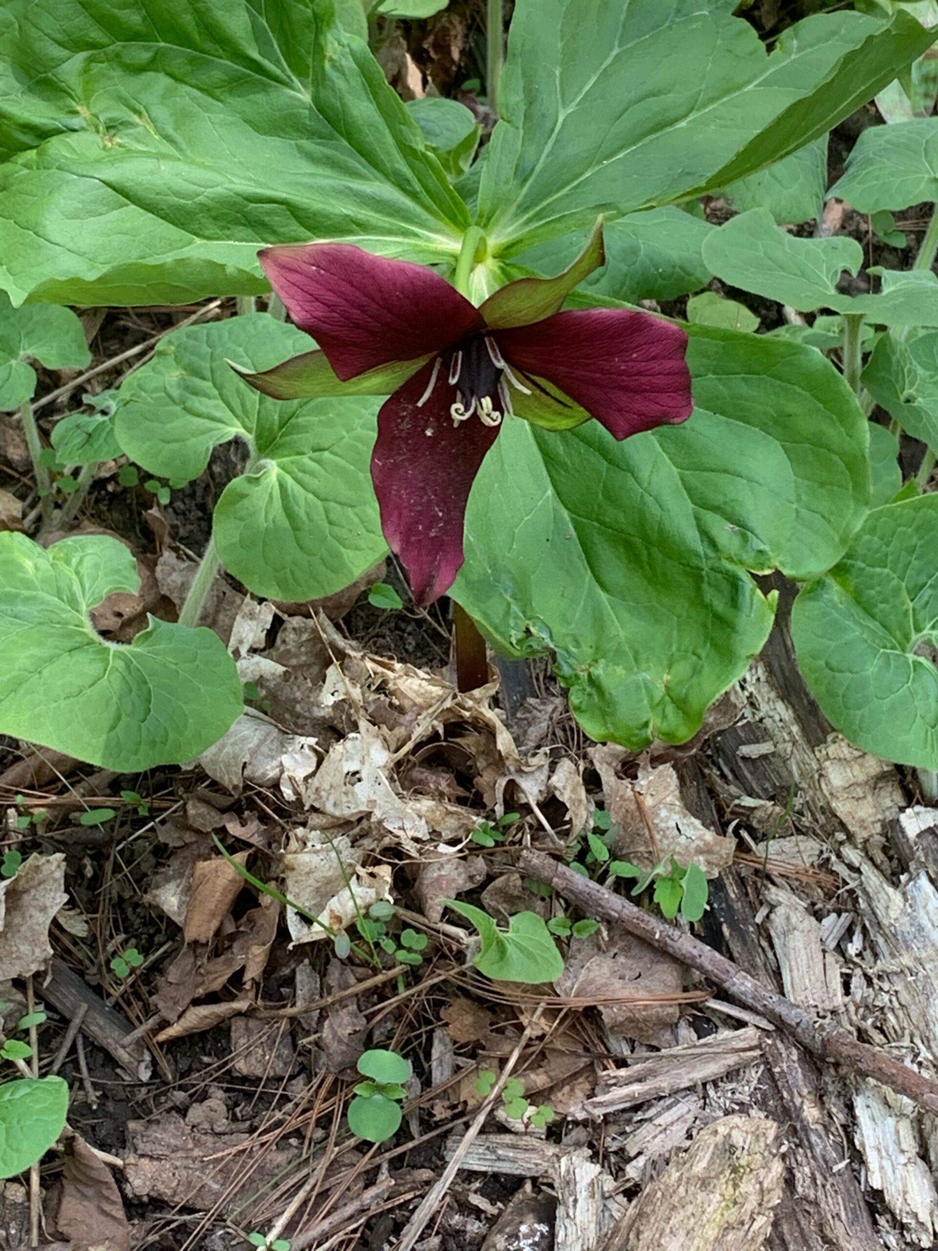
This is a favourite loop hike in Beaver Valley. We will be hiking in the Duncan Crevice Caves Provincial Nature Reserve, with a visit to Pinnacle Rock. If we wish, we can finish the morning off the morning with a scramble through the short 190 metre Metcalfe Crevice Side Trail, an amazing spot. Please ensure you arrive at 8:15 a.m for an 8:30 a.m. start. Bring water and snacks. We’ll have a couple of short breaks and a mid hike break for snacks. Dress appropriately for the weather and trail conditions. Bring sunscreen and insect repellent or protective covering like a bug hat and long sleeves. You can use the “Click here to contact the hike leader” option in the hike listing if you have any questions.
Caledon Hills E2E in 4 - Hike #2
https://hikes.brucetrail.org/event/caledon-hills-e2e-in-4-hike-2/Sorry, the registration cut-off time for this hike has been reached.Not a member? Click here to join today!This is a Multi-Day Hike
You are signing up for the following dates and times:
2026-05-24 at 08:30Hosting Club: Caledon Hills
Category: End-to-End
Location (Google Maps): Roadside parking on Coolihans Sideroad, east of where the trail crosses the road – km 35.0
6485 Coolihans Side Rd, Caledon, ON L7K 0P8, CanadaHike Leader(s): Dan Patterson Click here to contact Hike Leader(s)
Pace: Medium – 3 to 4 km/hour
Terrain: Moderate – some hills and/or some poor footing
Distance: 16.3 kmDescription
We will meet at Coolihans Side Road at 8:30 a.m. and shuttle to 5th Line EHS parking at Hockley Road at 9:00 sharp.This is an End-to-End hike series to complete the Caledon section of the Bruce Trail in 4 hikes. We will be hiking from the north end to the south end. Join for all or as many hikes as desired – you will need to register for each hike in the series which will take place on the following dates: May 17, 24, June 7, 21 Since this is a group hike, please consider your fitness level before registering. We will be walking at a pace of 3 km – 4 km per hour and hikers will need to keep up with the person in front of them for the duration of the hike. The hike series will also involve car shuttles and every hiker is expected to participate as drivers.
Weather conditions can be variable, dressing in layers is recommended. Hiking boots are required and hiking poles are strongly recommended. Bring plenty of fluids, electrolytes and a snack. This section is challenging with many hills.
Smokey Hollow Lollipop Hike
https://hikes.brucetrail.org/event/smokey-hollow-lollipop-hike/Sorry, the registration cut-off time for this hike has been reached.Not a member? Click here to join today!Hosting Club: Iroquoia
Category: My First Hike
Location (Google Maps): King Road Side RoadHike Leader(s): Kirsten McCarthy Click here to contact Hike Leader(s)
Pace: Medium – 3 to 4 km/hr
Terrain: Moderate – Some hills and/or some poor footing, Slippery and Steep Sections
Distance: 6-7kmDescription
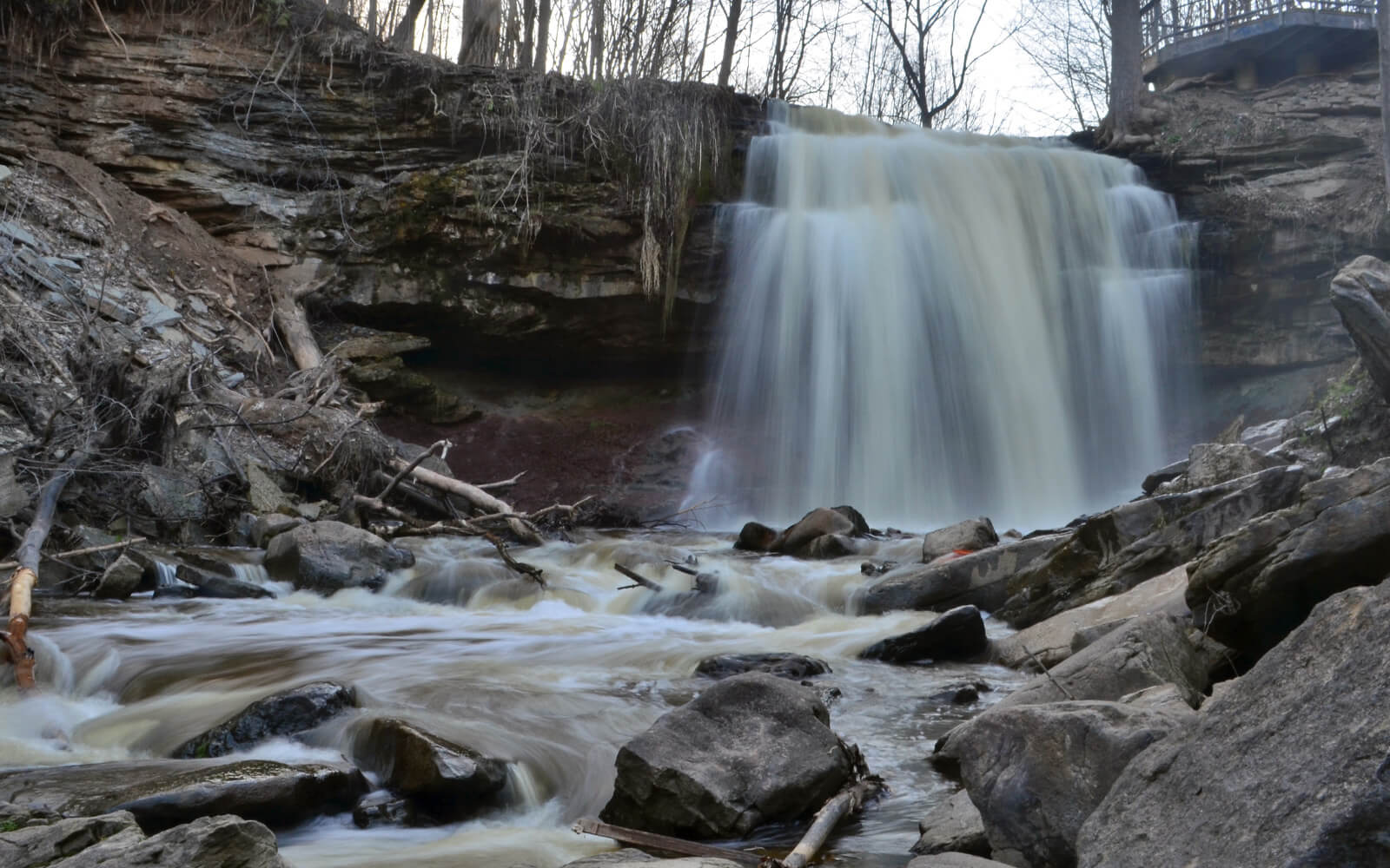
Are you new to hiking? Interested in learning more about the Bruce Trail? Join me for a lovely morning in nature as we hike from our cars to Smokey Hollow Waterfall and back completing this Lollipop hike. Along the way, I’ll provide some safety tips for successful and enjoyable hiking. Hikers who are new to hiking The Bruce Trail will receive a “My First Hike” badge. Please bring enough water (Min. 2L), proper hiking boots, snacks and hiking poles as there are some steep sections. We’ll stop at the waterfall for pictures and snacks, about halfway through the hike.
Walk In Nature Series (WINS) - Walter's Falls area
https://hikes.brucetrail.org/event/walk-in-nature-series-wins-walters-falls-area/Sorry, the registration cut-off time for this hike has been reached.Not a member? Click here to join today!Hosting Club: Sydenham
Category: General Hike
Location (Google Maps): Click the Google Maps link to take you to there. Meet and park 250 m west of Grey Rd 29 on Holland-Sydenham Townline, near Walter’s Falls. In the Bruce Trail Reference, Edition 31, meet at km 10.5 on Map 29.Hike Leader(s): Stewart Brown Click here to contact Hike Leader(s)
Pace: Medium: 3 to 4 km/h
Terrain: Moderate: Some hills and/or poor footing
Distance: 5 kmDescription
A diverse and rich natural area awaits you on the main trail and side trail along Walter’s Creek to Walter’s Falls and as we return on the other side of the creek. We will stop at several points of interest including a great views of the Falls from in front of the Inn.
CANCELLED - Canada Goose to Speyside (E2E)
https://hikes.brucetrail.org/event/canada-goose-to-speyside-e2e-4/Sorry, the registration cut-off time for this hike has been reached.Not a member? Click here to join today!Hosting Club: Iroquoia
Category: General Hike
Location (Google Maps): Meet at 9:15 in the parking lot on 22 Side Rd, just off Fourth Line.Hike Leader(s): Karen Bergmann Click here to contact Hike Leader(s)
Pace: Medium – 3 to 4 km/hr
Terrain: Moderate – Some hills and/or some poor footing
Distance: 8 kmsDescription
Meeting at 9:15 am in the Bruce Trail parking lot on 22 Side Rd, just off Fourth Line, we will carpool to 15 Side Road and hike back along the main trail and Canada Goose Side Trail. There are some rocky parts to this hike, so be prepared. Bring water and snack, as needed.Cancelled for your safety 🇨🇦 HISTORIC HIKE - LAURA SECORD LEGACY TRAIL PART 2 - NIAGARA COLLEGE TO DECEW HOUSE HERITAGE PARK, THOROLD - 17 KM
https://hikes.brucetrail.org/event/%f0%9f%87%a8%f0%9f%87%a6-historic-hike-laura-secord-legacy-trail-part-2-niagara-college-to-decew-house-heritage-park-thorold-17-km/Sorry, the registration cut-off time for this hike has been reached.Not a member? Click here to join today!Hosting Club: Toronto
Category: Car Hike
Location (Google Maps): Meet at 9:30 am, Decew House Heritage Park, 2370 Decew Rd, Thorold, ON L0S 1E6, coordinates coordinates 43.107612, -79.249647.
We will car shuttle from there to the start of the hike.Hike Leader(s): Jeanette Vincent Click here to contact Hike Leader(s)
Pace: Moderate (3-4 km/hr)
Terrain: Level 2 (Intermediate – some hills and uneven surfaces, rocks and roots underfoot)
Distance (km): 17kmDescription
NIAGARA COLLEGE TO DECEW HOUSE HERITAGE PARK, THOROLD – 17 KMAbout the historic hike (part 2): This hike is part 2 of the series of 2 hikes. We will hike Laura Secord Legacy Trail, a modern day approximation of Laura’s actual route from her homestead in Queenston to DeCew House in Thorold where she delivered her fateful message to Lt. Fitzgibbon on June 22, 1813. Divided into five distinct stages and encompassing everything from ancient forested trails, a college, universities to modern city sidewalks and urban parks, to meadows, climbing the escarpment, valley descents, crossing bridges and finishing on the Bruce Trail to Laura’s final destination Decew House Heritage Park. The 32km trail route was developed based on historical authenticity, safety, and natural ambiance.
We will end Laura’s journey exploring the Thorold’s Indigenous Unity Garden which includes the First Nations Peace Monument celebrating our relationship to the Indigenous community in the Niagara Region.
Congratulations on your successful completion of the Laura Secord Legacy Trail!“Laura Secord – Walk Into History” – background on Laura to outline Laura’s remarkable effort to warn a British officer about an impending attack by the invading American forces. – the impact that this one person had on the War of 1812. – the effort to commemorate Laura’s 32 km “walk” 200 years later (2013) and Bob Rennie’s involvement in the Secord Walk commemoration and unveiling of the related First Nations memorial near the DeCew house. Bob will deliver the talk in a War of 1812 uniform similar to that of Lt James Ftitzgibbon (the officer Laura went to warn).
About the guest: Bob Rennie UE is an amateur historian and historical living history reenactor. Bob has given many presentations on various aspects of Canada’s early history and spends much of his time at War of 1812 enactments and commemorations. He is a quest speaker at the GVTA (Grand Valley Trails Association) AGM, Tuesday May, 12, 6:30 to 8:30 pm at the Forest Heights branch of the Kitchener Public Library. Bob will speak from 7:30 to 8:30pm.
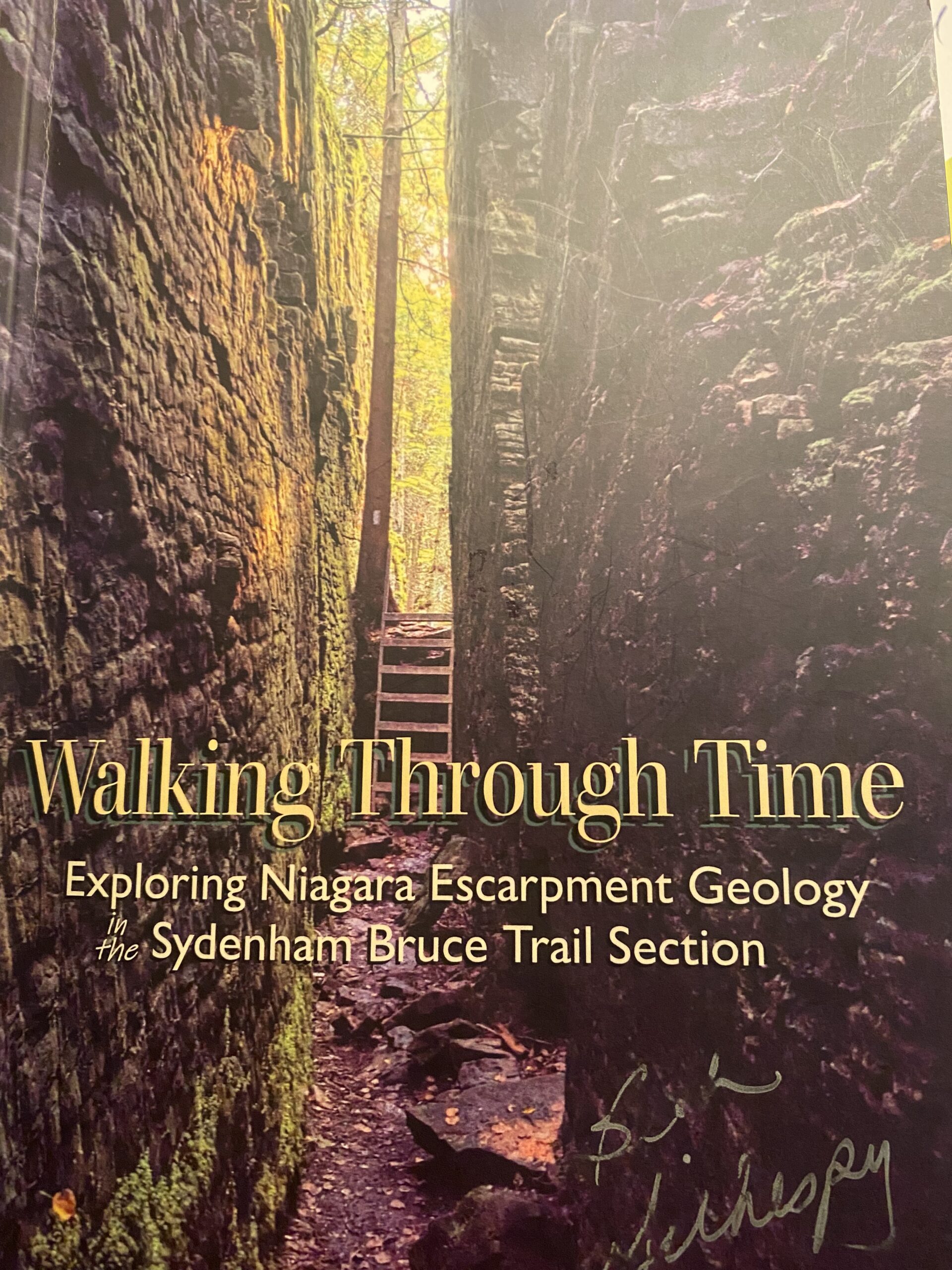
Geology Hike and Badge Series - Crooked Toe Road
https://hikes.brucetrail.org/event/geology-hike-and-badge-series-crooked-toe-road/Sorry, the registration cut-off time for this hike has been reached.Not a member? Click here to join today!Hosting Club: Peninsula
Category: Geology Hike
Location (Google Maps): Crooked Toe RoadHike Leader(s): Beth Gilhespy Click here to contact Hike Leader(s)
Pace: Leisurely (2.0 – 3.0 km/h): A relaxed pace with frequent breaks and a focus on enjoyment.
Terrain: Easy: Flat forested sections or lowland trails.
Distance: 5.5Description
Join the adventure and earn the inaugural Peninsula Geology Badge! Over a stretch of 13 hikes and a couple of extra stops, we will explore the fascinating geology of the Peninsula to learn about the rocks, the shoreline features, glaciation, fossils and all things earthy. The 13 hikes are from the book “Walking Through Time – Exploring the Geology of the Saugeen (Bruce) Peninsula”. Having a copy will give you a lot of great information, but you do not have to purchase the book to attend and enjoy the hikes. Just bring your curiosity! We will make sure to hit all the locations that qualify for the beautiful new Walking Through Time – Saugeen (Bruce) Peninsula geology hike badge. If you would like to purchase a book I will have some available on the hikes, or you can pick one up from the BTC Head Office, at Ginger Press in Owen Sound, Suntrail Source for Adventure in Hepworth, the Shop at 84 Main in Lion’s Head and at Reader’s Haven in Tobermory.You are welcome to come on just a few of the hikes or on all of them, and the dates and hikes are as follows:
Date Geology Hike km
Saturday May 2, 2026 Colpoy’s Bay 9.0
Saturday May 9, 2026 Gravelly Point (am) and Rural Rocks (pm) 8.6
Saturday May 16, 2026 Malcolm Bluff 7.3
Sunday May 17, 2026 White Bluff/Smokey Head 11.8
Sunday May 24, 2026 Crooked Toe Road 5.5
Sunday May 31, 2026 Hope Bay 8.1
Sunday June 14, 2026 Boundary Bluffs 5.2
Saturday July 4, 2026 Cape Dundas 6.2
Saturday July 11, 2026 Beth Gilhespy Side Trail 7.6
Saturday August 8, 2026 Lion’s Head 11.0
Saturday August 15, 2026 Dyer’s Bay Loops 7.5
Saturday August 22, 2026 North Saugeen (Bruce) Shoreline 8.0
Meeting times will vary depending on the hike, but will generally be some time between 9 am and 10 am. Information on exact meeting times and locations will be sent out a few days prior to the hike.

Side Trails Hike #8
https://hikes.brucetrail.org/event/side-trails-hike-8/Sorry, the registration cut-off time for this hike has been reached.Not a member? Click here to join today!Hosting Club: Niagara
Category: Loop
Location (Google Maps): Ellis Property, Twenty First St Jordan StationHike Leader(s): Lynskie Click here to contact Hike Leader(s)
Pace: Brisk 4-5 km/hr
Terrain: Moderate: some hills and some poor footing
Distance: 11kmsDescription
This is a loop hike.
Park at Ellis Property on Twenty First, we will start our hike on the Twenty Mile Creek Side Trail. We will then hike Jordan Hollow Side Trail until it reaches main trail. Go left on the Main Trail and continue to km 56.0 where the trail crosses 19th Street.
Shortly after, take the Jim Rainforth ST until it reconnects with the Main Trail. Turn right on Main Trail and follow it back to where it meets Jordan Hollow Side Trail. Take the Side trail back to the parking lot. We will then drive to Mountainview Conservation Area parking Lot (km 73.5) N 43.157888º, W 79.497415º and follow the main trail until it meets Mountainview ST. Take Mountainview ST until it ends at main trail. Turn right onto Main Trail until it meets Beamsville Bench ST. Take Beamsville Bench ST until it meets Angel ST. Take Angel ST out and back. Turn left back onto Beamsville Bench ST and follow it until it meets the main trail. Go left on main trail and follow it back to parking lot.Participate in all 9 scheduled hikes in the NBTC Side Trail Challenge or hike the side trails on your own. Submit your photos to collect the NBTC Side Trail badge. Badges will be awarded at the end of all 9 hikes. $10 for members and $15 for non members
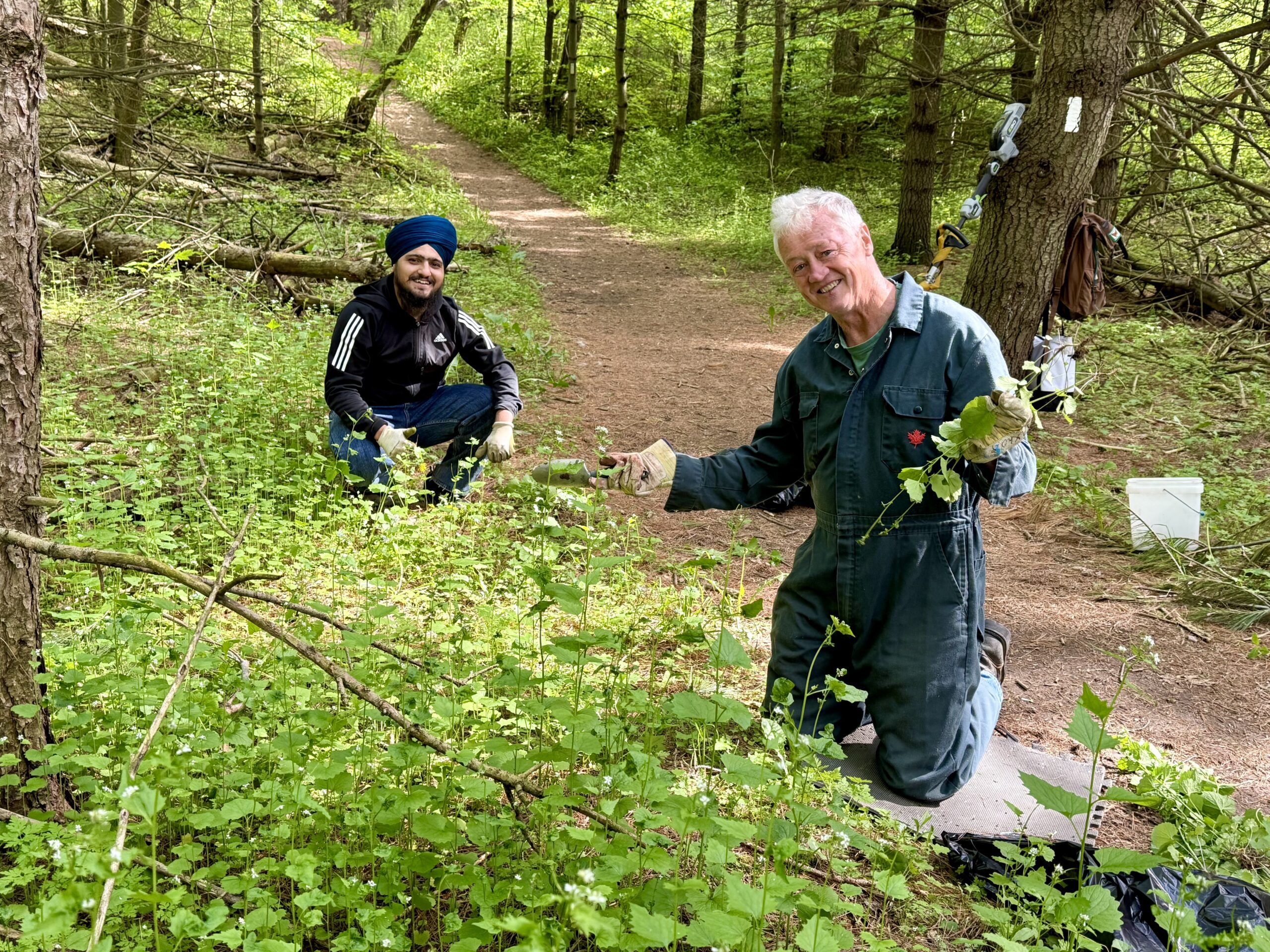
Invasive Plant Removal
https://hikes.brucetrail.org/event/invasive-plant-removal-2/Sorry, the registration cut-off time for this hike has been reached.Not a member? Click here to join today!Hosting Club: Niagara
Category: Leisurely
Location (Google Maps): 85 Park Rd S, Grimsby, ONHike Leader(s): Michele Altobelli Click here to contact Hike Leader(s)
Pace: Leisurely <3 km/hr
Terrain: Moderate: some hills and some poor footing
Distance: 4kmDescription
Join us to HELP FILL THE CRIB!!We will gather on Park Road, hike in from Ridge Road pulling invasive plants such as garlic mustard and greater celandine along the way (reusable grocery bags or garbage bags work well). Once at the crib location, we will dump our bags, continue pulling in that area for a while, dump again, then hike back out. Plenty of native spring plants to admire along the way – reducing invasive plants will give these species a chance to thrive!
- you must register and submit a completed waiver for this hike
- Students under 16 MUST be accompanied by a parent/guardian on this hike (please refer to the BTC link https://brucetrail.org/wp-content/uploads/2022/06/VOL.05.01_Minors_Volunteering_Policy_-_Approved_February_2016.pdf )
- 16 or more but under 18? Bring a waiver signed by a guardian.
- students wishing to receive community service hours (4Hours) MUST bring service forms from school.
- Please wear clothes for work – long pants tucked into socks, appropriate footwear (no sandals), long sleeves and work gloves
- please bring empty bags for collecting
- THANK YOU for your interest!
GeoHike - Chedoke Radial Trail
https://hikes.brucetrail.org/event/geohike-chedoke-radial-trail/Sorry, the registration cut-off time for this hike has been reached.Not a member? Click here to join today!Hike open to BTC Members only.
Hosting Club: Iroquoia
Category: Geo Hike
Location (Google Maps): [Chedoke Golf Club Parking Lot] Meet at the western end of the parking lot at the foot of the Chedoke Stairs. Please DO NOT park too close to the Golf Club house.Hike Leader(s): Ann Grindall Click here to contact Hike Leader(s)
Pace: Leisurely – 3km/hr or less
Terrain: Moderate – Some hills and/or some poor footing
Distance: 4 kmDescription
An introduction to the geology of the Niagara Escarpment in the Hamilton Region.Explore the ancient story etched into the Niagara Escarpment on this guided hike through the Hamilton region. Together, we’ll uncover how layers of rock were formed hundreds of millions of years ago, when this landscape lay beneath a shallow sea. As we follow the escarpment’s edge, we’ll trace its transformation over time. From the initial deposition of limestone, shale, and dolostone to the powerful forces of erosion that sculpted its dramatic cliffs, valleys, and waterfalls. Along the way, we’ll look at how the escarpment continues to evolve today, shaped by wind, water, and time.
Please meet up at 1:30 pm (1/2 hour before Hike Start) to give us time for check-in and pre-hike info.
Please bring:
🥾 Dress for the weather and bring layers, sturdy footwear (hike boots or hike shoes recommended), Hiking poles (optional).
💧 1 L water, snacks, ID/health card, small first aid kit. - 25May 25, 2026
Jones Bluff
https://hikes.brucetrail.org/event/jones-bluff/Sorry, the registration cut-off time for this hike has been reached.Not a member? Click here to join today!Hosting Club: Sydenham, Peninsula
Category: Health & Nature Hike
Location (Google Maps): We shall meet in Bluewater Park in Wiarton near the washrooms and the Wiarton Willy statue. From there we will carpool to the trailhead as the parking is limited there.Hike Leader(s): Cindy Paczkowski Click here to contact Hike Leader(s)
Pace: Leisurely: 3 km/h or less
Terrain: Moderate: Some hills and/or poor footing, There might be muddy sections., There might be sections with water on the trail.
Distance: Approx. 11 kmDescription
From Bluewater park we will carpool to the trailhead which is west of km 21.5 on map 36 at the bend on the grassy shoulder of Coveny’s road. We head north on Coveny’s side trail to the main white blazed trail. We hike on the main trail along Jones Bluff in a counter clockwise direction for about 8 km. Then return via Jones Bluff side trail and Knapp’s side trails. The views and the wildflowers will be beautiful. Please be prepared for insects with spray, long sleeves and long pants.EASY DOES IT HIKE, Welland Canal path
https://hikes.brucetrail.org/event/easy-does-it-hike-welland-canal-path/Sorry, the registration cut-off time for this hike has been reached.Not a member? Click here to join today!Hosting Club: Niagara
Category: Leisurely
Location (Google Maps): Allanbride Bridge (West of bridge)Hike Leader(s): Diane Marlatt Click here to contact Hike Leader(s)
Pace: Leisurely <3 km/hr
Terrain: Easy: mostly flat, good footingDescription
Seven Rivers Series - Hike 6 of 7
https://hikes.brucetrail.org/event/seven-rivers-series-hike-6-of-7/Sorry, the registration cut-off time for this hike has been reached.Not a member? Click here to join today!Hosting Club: Caledon Hills
Category: General
Location (Google Maps): Pretty River – Blue Mountains Section.
Meet at the parking lot on Pretty River Road north of km 46.8.Hike Leader(s): Nancy Mooney Click here to contact Hike Leader(s)
Pace: Medium – 3 to 4 km/hour
Terrain: Moderate – some hills and/or some poor footing, Strenuous – hilly with steep climbs and some poor footing
Distance: 12 kmDescription
This is the sixth hike in the series and goes through Pretty River Valley Provincial Park including the Highest Point on the Bruce Trail. - 26May 26, 2026
Long Haulers Hike NEW TIME NEW LOCATION
https://hikes.brucetrail.org/event/long-haulers-hike-new-time-new-location-2/Sorry, the registration cut-off time for this hike has been reached.Not a member? Click here to join today!Hosting Club: Niagara
Location (Google Maps): Short Hills Wiley Road, Thorold
Pace: Fast 5+ km/hr
Terrain: Moderate: some hills and some poor footing
: 10k+Description
Back to our regular Spot for the Tuesday Long Hike. Note the new location. We will hike the trails around Short Hills Dress for the weather and bring sunscreen bug spray, poles snack and drink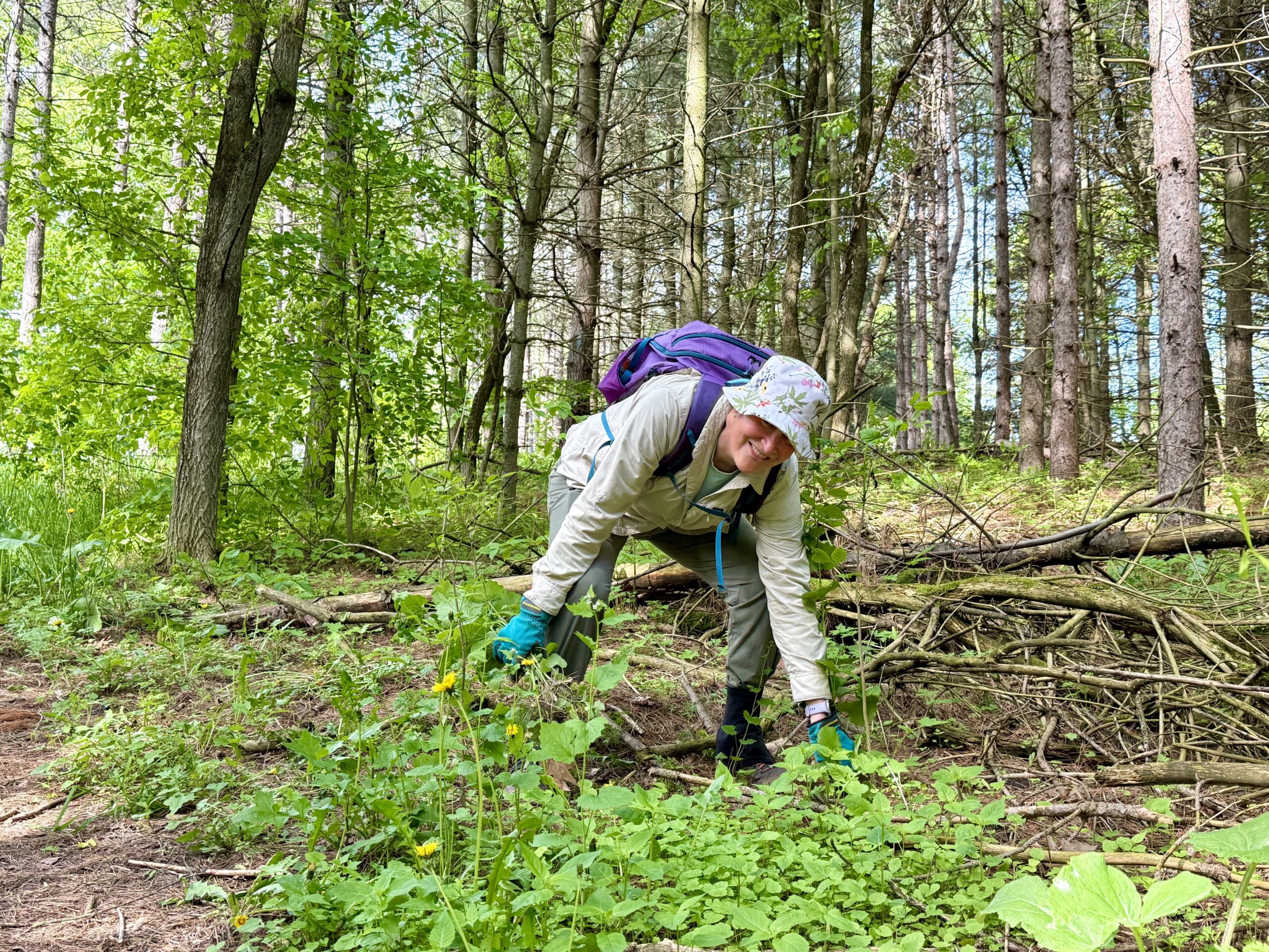
Habitat Restoration Project - Controlling the Spread of Garlic Mustard
https://hikes.brucetrail.org/event/habitat-restoration-project-controlling-the-spread-of-garlic-mustard-2/Sorry, the registration cut-off time for this hike has been reached.Not a member? Click here to join today!Hosting Club: Caledon Hills
Category: Habitat Restoration Project
Location (Google Maps): Meet at the parking lot on the east side of 3rd Line EHS, 43.992646, -80.047917.Directions: From ON-10 head east on Hockley Rd./Dufferin County Rd. 7 for 6.5 km. Turn left onto 3rd Line EHS and drive for 1.0 km. Parking is on the right.
Hike Leader(s): Sandy Green Click here to contact Hike Leader(s)
Pace: Leisurely – 3 km/hour or less
Terrain: Moderate – some hills and/or some poor footing
Distance: 2 kilometresDescription
Volunteers are needed to help control the spread of garlic mustard at the Hockley Valley Provincial Nature Reserve. Join Ron and Sandy to pull the invasive species by hand or if you prefer, bring a small trowel or dandelion weeder. Wear long sleeves and long pants. Pack gloves, sunscreen, insect repellent, a beverage, and a snack. The work is satisfying, and the camaraderie is always fun. All are welcome to help enhance biodiversity.9:15 Short Hike, Rotary Park, St. Catharines
https://hikes.brucetrail.org/event/915-short-hike-rotary-park-st-catharines-21/Sorry, the registration cut-off time for this hike has been reached.Not a member? Click here to join today!Hosting Club: Niagara
Category: Hike
Location (Google Maps): Rotary Park, 376 Regional Rd 69, St CatharinesHike Leader(s): Debbie Demizio Click here to contact Hike Leader(s)
Pace: Medium
Terrain: Moderate
Distance: 6 kmDescription
Hike the trails around Rotary Park, St. Catharines. Please bring water, hiking poles and appropriate footwear.Forks of the Credit Loop from Willoughby Road
https://hikes.brucetrail.org/event/forks-of-the-credit-loop-from-willoughby-road/Sorry, the registration cut-off time for this hike has been reached.Not a member? Click here to join today!Hosting Club: Dufferin Hi-Land
Category: Tuesday Hike
Location (Google Maps):Caledon Hills Secion Map 15, Met at intersection of Willoughby Rd and Escarpment SR (km 15.8)
Hike Leader(s): Inge Eckerich, Tony Evangelista, Les Babbage, Julie Daley Click here to contact Hike Leader(s)
Pace: Leisurely
Terrain: Moderate
Distance: 9 Km. Short hike 5 kmDescription
We will hike along the Main Trail to the end of Puckering Lane and continue into Forks of the Credit Provincial Park and loopback. Short hike will turn back at Puckering Lane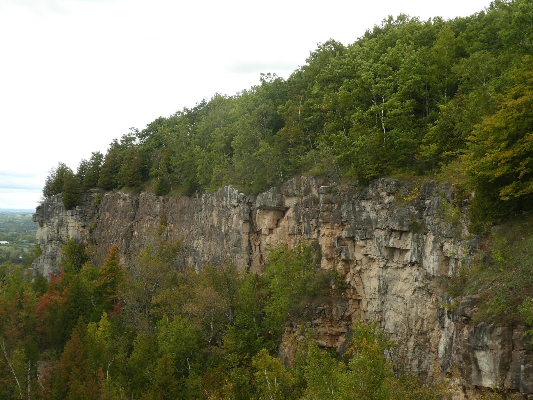
Kelso Summit (reservation required)
https://hikes.brucetrail.org/event/kelso-summit-reservation-required-2/Sorry, the registration cut-off time for this hike has been reached.Not a member? Click here to join today!Hosting Club: Iroquoia
Category: General Hike
Location (Google Maps): Kelso Summit parking lot at 9:15 am (reservation required)Hike Leader(s): Karen Bergmann Click here to contact Hike Leader(s)
Pace: Medium – 3 to 4 km/hr
Terrain: Moderate – Some hills and/or some poor footing
Distance: 8 kmsDescription
Meet at 9:15 in the Summit parking lot. We will explore the trails for a large loop and enjoy spring wildflowers along the way. Reserve your time at conservationhalton.ca for KELSO SUMMIT.Urban Walk: Valley View Park
https://hikes.brucetrail.org/event/urban-walk-valley-view-park-thornhill-171/Sorry, the registration cut-off time for this hike has been reached.Not a member? Click here to join today!Hosting Club: Toronto
Location (Google Maps): Parking lot is off Sycamore Drive, East of Bayview , across Starbucks plaza
Bus 91 from Finch East station stops at Sycamore station.Hike Leader(s): MOHAMMAD AGHAMIRI Click here to contact Hike Leader(s)
Pace: Moderate (3-4 km/hr)
Terrain: Hilly, Level 2 (Intermediate – some hills and uneven surfaces, rocks and roots underfoot)
Distance (km): 6-7 kmDescription
We will explore Valleyview and Maple View parks, and walk along German Mill Creak, in return we stop in Huntington park and have snack under beautiful shed.Although this is considered an “Urban Walk”, you can expect some hills up and down and uneven surfaces with tree roots. Please bring hiking poles, Ice cleats water and snacks.
Hilton Falls Conservation Area Trails
https://hikes.brucetrail.org/event/hilton-falls-conservation-area-trails-5/Sorry, the registration cut-off time for this hike has been reached.Not a member? Click here to join today!Hosting Club: Iroquoia
Category: General Hike
Location (Google Maps): Hilton Falls Conservation Area parking lot, Campbellville Rd/Side Rd 5 East of Guelph Line Rd. Reservation required along with Conservation pass or fee for parking.Hike Leader(s): Karen Capindale-Smith Click here to contact Hike Leader(s)
Pace: Brisk – 4 to 5 km/hr
Terrain: Easy – Mostly flat and usually good footing
Distance: 13kmDescription
We will hike the Beaver Dam loop and part of the Hilton Falls and Red Oak Trails at a brisk speed. There will an opportunity to visit the falls and stop for other sights along the way but please know that we will be moving at a clip. Please bring water, a snack and appropriate layers for the weather. Note: the finish time has been extended by 45 min to ensure the completion of the full 13km while still having an opportunity to enjoy the scenery/take breaks.Baked goods can be expected 🙂
Tuesday Trekkers- Dufferin (km 0-19.4) 1of 3
https://hikes.brucetrail.org/event/dufferin-km-0-19-4-1of-3/Sorry, the registration cut-off time for this hike has been reached.Not a member? Click here to join today!Hosting Club: Beaver Valley
Location (Google Maps): Meet at Mono Cliffs Community Centre. 200m south of Mono Centre (County rd 8) Park in gravel lot
We will shuttle to roadside parking on 1st line (km19.4) Map19 Ed 31Hike Leader(s): Kristina Rettie Click here to contact the hike leader.
Pace: Brisk, Medium
Terrain: Moderate, Some rocky footing, Some steep sections, Strenuous
Length of Hike: 20 kmDescription
This Dufferin E2E will take place over 3 Tuesdays. Come out for all of them and earn you Dufferin E2E badge (you can apply for this independenly) or just come to the ones that interest you. We will start at km 0 and make our way north to km 55.5 covering the entire Dufferin section.This will be a car shuttle hike so please come with your car passenger ready. We will all take turns being the shuttle driver.
This time of year we can expect all types of trail conditions. Please be prepared with for the condition of the day.
Bring water lunch and a snack
Please no dogs
Walk In Nature Series (WINS) Tuesday Summer Evenings - West Rocks
https://hikes.brucetrail.org/event/walk-in-nature-series-wins-west-rocks/Sorry, the registration cut-off time for this hike has been reached.Not a member? Click here to join today!Hosting Club: Sydenham
Category: General Hike
Location (Google Maps): Click the Google Maps link to take you there. Meet and park at the dead end of Concession 3, north of Grey Rd 5 near Creamery Hill/Waverley Heights in the former Derby Township. In the Bruce Trail Reference, Edition 31, meet just past km 96.1 on Map 32.Hike Leader(s): Stewart Brown Click here to contact Hike Leader(s)
Pace: Medium: 3 to 4 km/h
Terrain: Easy: Mostly flat and good footing.
Distance: 5 kmDescription
Tuesday evening WINS hikes begin at 6:30 p.m. as a way to enjoy the daylight and nice weather of summer evenings. Enjoy a loop in the West Rocks area on the forested trails with scenic lookouts over Owen Sound. - 27May 27, 2026
WEDNESDAY WALKERS - Margaret Paull ST Loop
https://hikes.brucetrail.org/event/wednesday-walkers-margaret-paull-st-loop-4/Sorry, the registration cut-off time for this hike has been reached.Not a member? Click here to join today!Hosting Club: Beaver Valley
Location (Google Maps): Park on the 6th Line, access from Hwy 119, Km 13.7 Map 24, Edition 31
Hike Leader(s): Margaret Yaraskavitch Click here to contact the hike leader.
Pace: Medium
Terrain: Moderate
Length of Hike: 3.9 kmDescription
An enjoyable walk with lots of opportunities for stops and photos. We’ll walk by a creek, view a flowerpot and a waterfall, and see the E.C. Carr Observatory buildings along our route. Country laneways with farm views, as well. Please bring water.
Princess Point Exploration
https://hikes.brucetrail.org/event/princess-point-exploration/Sorry, the registration cut-off time for this hike has been reached.Not a member? Click here to join today!Hosting Club: Iroquoia
Category: General Hike
Location (Google Maps): Princess Point, 335 Longwood Rd. N., HamiltonHike Leader(s): Anne Armstrong Click here to contact Hike Leader(s)
Pace: Leisurely – 3km/hr or less
Terrain: Moderate – Some hills and/or some poor footing
Distance: Approx. 8 km.Description
Come explore the lovely trails of Princess Point on the south shores of Cootes Paradise. We will hike Princess Point Trail, Ginger Valley, Sassafras Point, Caleb’s Walk, Ravine Rd. and Churchill Park ending up back an our cars. Please meet in the parking lot of Princess Point at 9:45 for a 10:00 am. start. Paid parking or RBG Pass. Bring water, a snack, insect repellent and sunscreen. I will send out a message the day before the hike with my contact information in the event that you need to cancel the evening before or in the morning.Niagara Glen Short and Sassy
https://hikes.brucetrail.org/event/niagara-glen-short-and-sassy-8/Sorry, the registration cut-off time for this hike has been reached.Not a member? Click here to join today!Hosting Club: Niagara, Iroquoia
Category: Good Companions
Location (Google Maps):Niagara Glen, 3050 Niagara Parkway, Niagara-on-the-Lake, ON
Hike Leader(s): Craig Sim Click here to contact Hike Leader(s)
Pace: Medium – 3 to 4 km/hr
Terrain: Moderate – Some hills and/or some poor footing
Distance: 7k (approximate)Description
Loop hike in beautiful Niagara Glen, NOT using Whirlpool Trail. We meet in between Niagara Glen parking lot and building near lot. Pay parking or Niagara parks pass. Trail ranges from moderate to quite rocky, has hills and stairs. Watch footing. Lots of boulders and great views close to Niagara River. We descend steel stairs before and after hike. Wear hiking boots or shoes. Bring water, snack, appropriate layered clothing for the weather and rain gear. Optional beverage/food after. Niagara Glen is close to both Butterfly Conservatory and Floral Clock.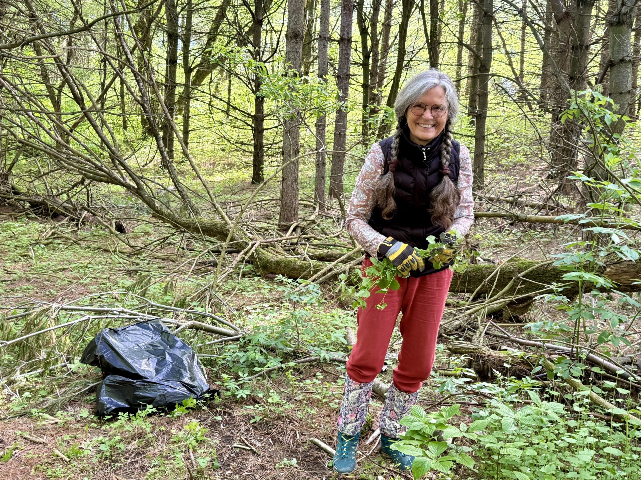
Habitat Restoration Project - Controlling the Spread of Garlic Mustard
https://hikes.brucetrail.org/event/habitat-restoration-project-controlling-the-spread-of-garlic-mustard-3/Sorry, the registration cut-off time for this hike has been reached.Not a member? Click here to join today!Hosting Club: Caledon Hills
Category: Habitat Restoration Project
Location (Google Maps): Meet at Hockley Valley Provincial Nature Reserve Parking Lot on Hockley Road, 43.972857, -80.056330.Directions: From ON-10 turn east onto Hockley Rd./Dufferin County Rd. 7. Drive for 5.1 kilometres.
Hike Leader(s): Sandy Green Click here to contact Hike Leader(s)
Pace: Leisurely – 3 km/hour or less
Terrain: Moderate – some hills and/or some poor footing
Distance: 2 kilometresDescription
Volunteers are needed to help control the spread of garlic mustard at the Hockley Valley Provincial Nature Reserve. Join Ron and Sandy to pull the invasive species by hand or if you prefer, bring a small trowel or dandelion weeder. Wear long sleeves and long pants. Pack gloves, sunscreen, insect repellent, a beverage, and a snack. The work is satisfying, and the camaraderie is always fun. All are welcome to help enhance biodiversity. - 28May 28, 2026
NEW TIME 8:00 Long Hike, Glen Road Jordan
https://hikes.brucetrail.org/event/new-time-800-long-hike-glen-road-jordan-2/Sorry, the registration cut-off time for this hike has been reached.Not a member? Click here to join today!Hosting Club: Niagara
Location (Google Maps):
3640 Glen Road Jordan
Pace: Fast 5+ km/hr
Terrain: Strenuous: hilly, with steep climbs, poor footing
: 10 kmDescription
Hike in and around Ball’s Falls and Jordan. Dress for the weather: bring bug spray, sunscreen drink and poles.Seven Rivers Series - Hike 7 of 7
https://hikes.brucetrail.org/event/seven-rivers-series-hike-7-of-7/Sorry, the registration cut-off time for this hike has been reached.Not a member? Click here to join today!Hosting Club: Caledon Hills
Category: General
Location (Google Maps): Humber River – Caledon hills Section.
Meet at the parking on Mono 5 Sideroad.Hike Leader(s): Nancy Mooney Click here to contact Hike Leader(s)
Pace: Medium – 3 to 4 km/hour
Terrain: Moderate – some hills and/or some poor footing, Strenuous – hilly with steep climbs and some poor footing
Distance: 12 kmDescription
This is the last hike in the series and takes us through the Humber Valley. Yay, another badge earned!Hiking around Jordan
https://hikes.brucetrail.org/event/hiking-around-jordan-56/Sorry, the registration cut-off time for this hike has been reached.Not a member? Click here to join today!Hosting Club: Niagara
Location (Google Maps): Sho’Arishon Park (Jordan Hollow)
Hike Leader(s): Bill Russell Click here to contact Hike Leader(s)
Pace: Medium 3- 4 km/hr
Terrain: Moderate: some hills and some poor footing
Distance: 7 kmDescription
Hiking in and around Jordan, Balls Falls and Jim Rainforth Trail alternating every 3 weeks.Urban Walk: Valley View Park
https://hikes.brucetrail.org/event/urban-walk-valley-view-park-thornhill-172/Sorry, the registration cut-off time for this hike has been reached.Not a member? Click here to join today!Hosting Club: Toronto
Location (Google Maps): Parking lot is off Sycamore Drive, East of Bayview , across Starbucks plaza
Bus 91 from Finch East station stops at Sycamore station.Hike Leader(s): MOHAMMAD AGHAMIRI Click here to contact Hike Leader(s)
Pace: Moderate (3-4 km/hr)
Terrain: Hilly, Level 2 (Intermediate – some hills and uneven surfaces, rocks and roots underfoot)
Distance (km): 6-7 kmDescription
We will explore Valleyview and Maple View parks, and walk along German Mill Creak, in return we stop in Huntington park and have snack under beautiful shed.Although this is considered an “Urban Walk”, you can expect some hills up and down and uneven surfaces with tree roots. Please bring hiking poles, Ice cleats water and snacks.

Urban Walk: Toronto Islands Evening Walk
https://hikes.brucetrail.org/event/urban-walk-toronto-islands-evening-walk-22/Sorry, the registration cut-off time for this hike has been reached.Not a member? Click here to join today!Hosting Club: Toronto
Location (Google Maps):
Jack Layton Ferry Terminal, by the gate to the Wards Island Ferry. Please arrive 20 minutes prior to departure to check in with hike leader.
From Union Station take the LRT and get off at the stop Ferry Docks.Walk up to the Ferry Docks on Queens Quay West, street level. at the foot of Bay Street.
Hike Leader(s): Miriam Stevens Click here to contact Hike Leader(s)
Pace: Leisurely (2-3 km/hr)
Terrain: Flat, Level 1 (Easy – mostly on flat, well maintained trails with hard-packed surface)
Distance (km): 6-9 kmDescription
After a day’s work come and “cool off” on the Toronto Islands free of fumes and traffic. Enjoy the view of the city skyline and Toronto’s beautiful island parkland.
Pack a dinner for a sit down picnic. Also bring a warm jacket and flashlight.
Return fare ticket for the ferry is $9.57 for adults, $6.15 for seniors
Please check the hike schedule for weather related cancellations (hike will be updated by 11:00 AM day of the hike if any changes)
Toronto Island evening hikes will take place every Thursday in May and June 2026.
Same time and same meeting place. No preregistration is required – just show up at the ferry docks at 5:40 PM and sign in with the hike leader. - 29May 29, 2026
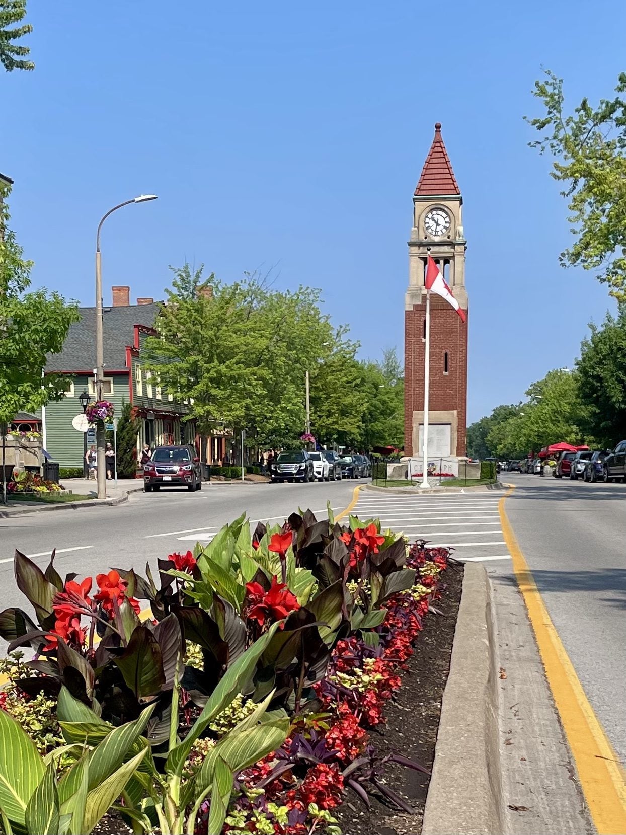
Niagara-on-the-Lake Tour
https://hikes.brucetrail.org/event/niagara-on-the-lake-tour-28/Sorry, the registration cut-off time for this hike has been reached.Not a member? Click here to join today!Hosting Club: Niagara
Category: Urban
Location (Google Maps): Park on King St near Centre St – at entrance to Veteran’s Memorial Park, Niagara-on-the-LakeHike Leader(s): Margaret Northfield Click here to contact Hike Leader(s)
Pace: Medium 3- 4 km/hr
Terrain: Easy: mostly flat, good footing
Distance: 6-7kmDescription
Each Friday we will explore historical Niagara-on-the-Lake while getting a moderate paced walk. Discover where the Niagara River meets Lake Ontario. Experience the Heritage District, woods and the Niagara Parkway.Some weeks may be totally on sidewalks and roads while others may include a mix of trail and paved pathways.
Great way to build up endurance for longer more strenuous hikes.
Plan to stay for conversation and a coffee at Sweets & Swirls, Community Centre, Niagara Stone Rd., NOTL
Niagara E2E #2: Louth Conservation Area to Quarry Road
https://hikes.brucetrail.org/event/niagara-e2e-2-louth-conservation-area-to-quarry-road/Sorry, the registration cut-off time for this hike has been reached.Not a member? Click here to join today!Hike open to BTC Members only.
Hosting Club: Dufferin Hi-Land
Category: General Hike
Location (Google Maps): Where the Bruce Trail crosses Quarry Road at km 67.9 BTC Map 4. Just north of Quarry Road and Fly Road (County Road 73). See Google Maps link for GPS.Hike Leader(s): Stuart Law Click here to contact Hike Leader(s)
Pace: Medium
Terrain: Slippery and Steep Sections, Moderate
Distance: 16 kmsDescription
Join us on a shuttle hike on the main trail taking in Balls Falls in the Jordan Valley and Cave Springs. Slippery muddy sections and rocks guaranteed. Please bring a garbage bag and an extra set of footwear for the ride back. Please also bring 2.5L of water, a snack, a lunch, bug spray, bug head net and sunscreen. Wear long sleeves and pants.
Georgian Bluffs - top of Kemble Mountain
https://hikes.brucetrail.org/event/georgian-bluffs-top-of-kemble-mountain-5/Sorry, the registration cut-off time for this hike has been reached.Not a member? Click here to join today!Hosting Club: Sydenham
Category: General Hike
Location (Google Maps): The Owen Sound Galaxy Cinema parking lot. Meet at the tall “Galaxy Centre” sign next to the traffic lights.Hike Leader(s): Ian Mills
Pace: Medium: 3 to 4 km/h
Terrain: Strenuous: Hilly with steep climbs and some poor footing., There might be muddy sections., There might be sections with water on the trail.
Distance: 9 kmDescription
This Hike is a great opportunity for fresh air and exercise. Plan for 3+ hours on the trail. We will amend our route accordingly if necessary. please pack a snack or lunch as we will be taking a break at the halfway point. We will start @ 142.6 km BTC Map 34 taking the Main Trail south looping with the following Side Trails (Mystery Cabin, Don Richards, Coles, Maple Cross Ridge & Nels Maher). Proper hiking footwear is required , a walking stick could be helpful, pack lots of water and insect repellent.Car Hike: Fitness Hike in the Forks of the Credit Provincial Park (ca 10 km) Apple Trees Blossom
https://hikes.brucetrail.org/event/car-hike-midweek-fitness-hike-in-the-forks-of-the-credit-provincial-park-ca-10-km-apple-trees-blossom-2/Sorry, the registration cut-off time for this hike has been reached.Not a member? Click here to join today!Hosting Club: Toronto, Caledon Hills
Category: Car Hike
Location (Google Maps):Forks of the Credit Provincial Park (McLaren Road entrance)
Hike Leader(s): Natalia Svechnikova Click here to contact Hike Leader(s)
Pace: Moderate (3-4 km/hr)
Terrain: Level 2 (Intermediate – some hills and uneven surfaces, rocks and roots underfoot)
Distance (km): 10 kmDescription
Please join me for an enjoyable fitness hike on a hilly part of the park and, hopefully with views of apple tress blossom. We will hike a 10 km loop with one section going up hill. The trail has mostly treed sections as well as a few open areas. There will be a lunch stop near the Credit River. Be prepared wearing comfortable cloths, hiking shoes/boots. Please bring at least 2 L of water, a light lunch/snacks, sun screen and bug spray optional. We will on the parking lot at the trail head and map poster to the right of the washroom facilities. You have to drive to the main entrance on the McLaren Road and pay for the parking.This car hike will be cancelled if the there is a heavy rain, storm etc in the forecast.
Beaver Valley- Epping to 40
https://hikes.brucetrail.org/event/beaver-valley-km-96-9-113-6/Sorry, the registration cut-off time for this hike has been reached.Not a member? Click here to join today!Hosting Club: Beaver Valley
Category: Car Pool
Location (Google Maps): Epping parking on Sideroad 19Hike Leader(s): Erin Lyttle Click here to contact Hike Leader(s)
Pace: Brisk 4-5 km/hr
Terrain: Strenuous: hilly, with steep climbs, poor footing
Distance: 13.5Description
This hike is for experienced hikers working on their Beaver Valley section end to end. We will meet at the BTC parking on Hwy 40 between Grey Road 7 and 3rd Line D (Google Maps: GC5V+93, Grey Highlands, ON N4L 1W7) and carpool to roadside parking at Epping Sideroad 19 Parking near Eric Winkler Parkway/Grey Road 7. (Slightly west of 686271 19 Siderd, Meaford, ON N4L 1W7)We will be hiking in spring conditions (mud, bugs, possible rain) so be prepared for it all. Please have your and poles at the ready and dress in layers including a waterproof outer layer. Hiking boots/shoes are mandatory. Please bring water/electrolytes and snacks, though we do not plan a meal break as this hike is scheduled between lunch and dinner time.
We will be shuttling to our starting point so please be prepared to participate in the shuttle.
Afternoon Hike - Halton Agreement Forest
https://hikes.brucetrail.org/event/afternoon-hike-halton-agreement-forest-5/Sorry, the registration cut-off time for this hike has been reached.Not a member? Click here to join today!Hosting Club: Iroquoia
Category: Afternoon/Evening Hikes
Location (Google Maps): Parking lot on 6th Line, about 3 kms up from Campbellville Rd. Small parking lot so plan to arrive between 4 and 4:15 pm.Hike Leader(s): Karen Bergmann Click here to contact Hike Leader(s)
Pace: Medium – 3 to 4 km/hr
Terrain: Moderate – Some hills and/or some poor footing
Distance: About 7 kmsDescription
Meet at 4:15 in the small parking lot on 6th Line. We will hike a few of the bike trails. Expect to see spring wildflowers in abundance. - 30May 30, 2026
Sunrise Ceremony for the opening of Jim Tovey Lakeview Conservation Area with birding afterwards
https://hikes.brucetrail.org/event/sunrise-ceremony-for-the-opening-of-jim-tovey-lakeview-conservation-area-with-birding-afterwards/Sorry, the registration cut-off time for this hike has been reached.Not a member? Click here to join today!Hosting Club: Toronto
Category: Urban Walk
Location (Google Maps): Marie Curtis Park by the washrooms. If coming by TTC, take bus 337 from Bloor St W at Islington Ave West side at 4:39 to Lake Shore Blvd. Change to any Westbound Streetcar to Long Branch Loop. Walk 10 minutes to our meeting spot.Hike Leader(s): Andrew Proczek Click here to contact Hike Leader(s)
Pace: Leisurely (2-3 km/hr)
Terrain: Flat, Level 1 (Easy – mostly on flat, well maintained trails with hard-packed surface)
Distance (km): 5-6 kmDescription
Please join me for the opening of the long awaited Jim Tovey Lakeview Conservation Area (10 years in the making). This will be an indigenous led ceremony to honour Grandfather Sun and open the conversation area by the Eagle Spirits of the Great Waters, starting at 6 am. The ceremony will be held in the Indigenous Teaching Amphitheater.Ceremony Schedule
5:30-6:00 am – Guests arrive and light refreshments (coffee/tea/pastries).
6:00-6:15 am – Raiden Levesque of Credit Valley Conservation will open the ceremony in a good way and conduct a pipe ceremony.
6:15-6:45 am – Eagle Spirits of the Great Waters Drummers.
6:45-7:00 am – Story telling and closing out ceremony.The Jim Tovey Lakeview Conservation Area is a newly built 26-hectare greenspace that transforms a degraded section of eastern Mississauga’s Lake Ontario shoreline. Located west of Marie Curtis Park, the site restores natural functions while reconnecting people and wildlife back to nature. This new greenspace will allow lakefront access unimpeded from Marie Curtis Park in Etobicoke all the way to Lakefront Promenade Park in Mississauga.
We will be joined by expert birder, Peter Sproule, who has guided us in back to back years at Colonel Samuel Smith Park to the Arsenal lands. Starting at 7 am we will bird and hike on the new Jim Tovey Lakeview Trails as well as on the Arsenal Lands, Marie Curtis and Etobicoke Creek trails.
Free parking available at Marie Curtis Park, however, the washrooms will not open until 9 am. We will make a nature stop in the woods before arriving at the Opening Ceremony.
For the future, Jim Tovey Lakeview Conservation Area has no road access or parking lot. The closest parking area is the large west parking lot at Marie Curtis Park. For our hike on Saturday, we are meeting on the east side of Etobicoke Creek by the washrooms.
https://cvc.ca/discover-our-parks/jim-tovey-lakeview-conservation-area/#faq
Falling Water Trail Badge Event - (participants hike independently, no hike leader)
https://hikes.brucetrail.org/event/falling-water-trail-badge-event-participants-hike-independently-no-hike-leader-4/Sorry, the registration cut-off time for this hike has been reached.Not a member? Click here to join today!Hosting Club: Beaver Valley
Location (Google Maps): Meet in the Beaver Valley Ski Club Lower parking lot at the far south end of the lot, past the tennis courts (do not park by the private picnic area near the river and bridge). Map 26, Edition 31 N44.357382, W80.543331
Hike Leader(s): Glenda Collings Click here to contact the hike leader.
Pace: Medium
Terrain: Some rocky footing, Some steep sections, Strenuous
Length of Hike: 30.1km You set your own pace, however a medium pace will get the job done in a timely fashion.Description
Come and test your mettle! This is a 30.1 km loop hike that traverses the beautiful, rugged upper Beaver Valley. It’s a challenging hike during which you’ll experience all that spring has to offer, including cascading creeks, waterfalls and possibly muddy conditions. Registrants should have experience with hiking long distances over strenuous terrain.Registration will be through the Bruce Trail Conservancy Online Calendar and will open at 8:30 a.m. on March 2, 2026. The $40.00 registration fee covers the cost of the online registration fee, check point refreshments and the badge.
Further details of the event will be emailed to participants once registration is received. For more information contact beavervalleytrailactivities@gmail.com
Sydenham Bruce Trail E2E Run - Day 7 of 8 Only
https://hikes.brucetrail.org/event/sydenham-bruce-trail-e2e-run-day-7-of-8-only/Sorry, the registration cut-off time for this hike has been reached.Not a member? Click here to join today!Hike open to BTC Members only.
Hosting Club: Sydenham, Peninsula
Category: Sydenham E2E Trail Run
Location (Google Maps): Day 7 of the E2E Trail Run of the Sydenham Bruce Trail section. Meeting at Massie Hills Parking on 6th Concession S.Hike Leader(s): Margie Gloade; Natalie Mechalko Click here to contact Hike Leader(s)
Pace: Fast (5.5 – 7.0 km/h+): A quick pace maintained by experienced hikers or trail runners.
Terrain: Difficult: Steep ascents/descents, rocky scrambling, and some rugged escarpment paths.
Distance: About 19kmDescription
This is a single-day registration – Day 7 of 8.The Sydenham Bruce Trail Club (SBTC), in partnership with the Peninsula Bruce Trail Club (PBTC), is excited to offer its first-ever trail running Sydenham End-to-End series in 2026. Join the fun for one of the eight days in this trail running series! The trail running Sydenham E2E series will take place over 4 weekends and 8 days, starting at 7:30am. Below is the start and end location and estimated distance for this day (subject to change slightly). The group will meet at the end location, and carpool to the start of each day’s route. You are expected to participate in shuttling vehicles.
Please carefully read the details below to understand the logistics, costs, important notes, and fitness required for this challenge.
Saturday, May 30, 2026: Woodford Community Centre to Massie Hills Parking off 6th Concession S; ~19km.
- When you register here, you are registering for only one day in the series. (You also have the option of registering for the whole series for $60 even if you aren’t able to make all eight days).
- These are group trail runs. It is not a race. It is not a hike. There may be a couple different pace groups that naturally form, but you will be expected to stay with a group and wait to regroup at key locations. Runners are expected to remain between the lead runner and the sweep at all times. Anticipate each day to be running for about 3+/- hours, at a pace ranging from 7-9 min./km.
- Participants are expected to have some experience trail running as this is difficult terrain. There are also some roads, and some active farm fields. In some locations throughout Sydenham, trail running will not be permitted near livestock. On roads, runners are expected to follow standard Highway Traffic Act regulations, crossing safely and running on the shoulder, in single file, facing oncoming traffic.
- Mandatory gear includes a whistle and minimum 250ml of water carrying capacity. Trail runners will need to carry their own water and fuel.
- At approximate mid-way points each day, there will be volunteer support arranged so you can fill up water bottles. Some snacks (e.g. oranges, bananas, pretzels, cookies, water) will be provided but please plan to be self-sufficient.
- Exercise care and caution and common sense on trails, especially when passing other trail users. Let others know you are coming and that you intend to pass. Headphones/earbuds are not permitted while participating in this group run.
- Participants must be age 16 years or older.
- Dogs are not permitted.
- This trail run is for BTC members only. To become a member, click here: https://brucetrail.org/.
- The designated meeting points will not incur any personal parking fees but parking space is limited. Participants are encouraged to car pool whenever possible.
The single day fee is $20. This fee covers snacks, vehicle shuttle, volunteer support, and a donation to the PBTC hike program. There is also an option to register for the whole series ($60).
As per BTC policy, no refunds will be considered 30 days before the series starts (not after April 1, 2026).
The trail run will go ahead rain or shine, however, in extremely inclement weather, a date may be cancelled and rescheduled, ideally prior to the May 31st finish date.
Blue Mountains E2E #4/4
https://hikes.brucetrail.org/event/car-hike-blue-mountains-e2e-4-4/Sorry, the registration cut-off time for this hike has been reached.Not a member? Click here to join today!Hosting Club: Toronto, Blue Mountains
Category: Car Hike
Location (Google Maps):Meet up location. 320 meters north of km 55.7 a small parking area on the east side of 2nd Line. GPS N44.449741, W80.307524
Hike Leader(s): Ross Estrella Click here to contact Hike Leader(s)
Pace: Brisk (4-5 km/hr), Moderate (3-4 km/hr)
Terrain: Challenging, Hilly, Level 2 (Intermediate – some hills and uneven surfaces, rocks and roots underfoot), Level 3 (Advanced – steep hills and some scrambling over boulders), Rocky
Distance (km): 18.5kmDescription
Day 3/4 of BMBTC E2E. Hikers must complete the entire Blue Mountain section to earn and receive their badge upon completion. Missed segment/s must be made up prior to the completion of the last segment to receive your badge. Hikers who are completing their missed section of BMBTC are welcome to join. This segment will pass thru Pretty River Valley Provincial Park and we’ll take the side trail to the Bruce Trail Highest Point. Expect some challenging rolling hills, rocks and underfoot trail but you’ll be rewarded with stunning beauty of the surrounding landscape. We’ll be on a moderate to brisk pace. Day hike essentials to bring; lunch/snacks, sufficient liquid hydration of your choice, sun screen, bug spray, head covering for sun protection and dress appropriately for the forecasted weather. As we are in the middle of spring season some section could be muddy/slippery therefore, hiking poles, waterproof hiking shoe and gaiter are strongly recommended. Fifteen minutes early arrival is expected and please make sure your car ready for shuttling. We’ll shuttle to parking area on the north side of County Rd 91, 850 meters west of Concession 10. GPS N44.388871, W80.236727.Cost of badge is Ten dollars for BTC members and Fifteen dollars for non members.
Car Hike: Hockley Crest, Airport Rd to Hockley Rd
https://hikes.brucetrail.org/event/car-hike-hockley-crest-airport-rd-to-hockley-rd-2/Sorry, the registration cut-off time for this hike has been reached.Not a member? Click here to join today!Hosting Club: Toronto, Caledon Hills
Category: Car Hike
Location (Google Maps):Meet at the Bruce Trail Parking Lot on Mono 5 Sideroad on the north side of the 5th Sideroad.
Hike Leader(s): Amir Alemohammad Click here to contact Hike Leader(s)
Pace: Moderate (3-4 km/hr)
Terrain: Flat, Hilly, Level 2 (Intermediate – some hills and uneven surfaces, rocks and roots underfoot), Variable
Distance (km): 12-14 kmDescription
Join us for a out and back hike in Hockley Crest. The route explores a diverse landscape of dense sugar maple and beech hardwood forests, open grassy meadows, active pine plantations, and steep ravines. We will explore the main and side trails of the Bruce Trail. Bring at least two liters of water and your favorite snacks. Boots mandatory, poles recommended. Be prepared for the ticks and bugs. This is a joint hike with the ORTA.Seaton Trail Pickering
https://hikes.brucetrail.org/event/car-hike-bethesda-trail-richmond-hill-36/Sorry, the registration cut-off time for this hike has been reached.Not a member? Click here to join today!Hosting Club: Toronto
Location (Google Maps): Seaton Trail Parking Lot, Pickering
Hike Leader(s): Mohammad Aghamiri Click here to contact Hike Leader(s)
Pace: Moderate (3-4 km/hr)
Terrain: Hilly, Level 2 (Intermediate – some hills and uneven surfaces, rocks and roots underfoot), Variable
Distance (km): 14-15 kmDescription
We will hike along Seaton trail and enjoy the lovely scenery of forest and river.
• Please dress appropriately for the weather.
• We will have short water, picture, Bio and a 15 minute snack breaks. Everyone is welcome!Please bring lots of water and snacks ,hiking poles are recommended
phone number for the day of hike 289 588 6482
Seven Rivers Hike Badge Series- Hike 1
https://hikes.brucetrail.org/event/seven-rivers-hike-badge-series-hike-1/Sorry, the registration cut-off time for this hike has been reached.Not a member? Click here to join today!Hosting Club: Dufferin Hi-Land
Category: General Hike
Location (Google Maps): Pretty River Blue Montains Section Map 23
Parking: “Snowdrifters Parking Area” or snowmobile parking lot at 549949 Pretty River Rd, Nottawa which is just west of Clearview Collingwood Townline and North of Duntroon.Hike Leader(s): Tristan Goguen and Pat Foley Click here to contact Hike Leader(s)
Pace: Medium
Terrain: Moderate
Distance: 11.9 KmDescription
Today we will walk north bound on the main trail starting at Pretty River Rd. Where the trail crosses 6th side rd we will head west for 500 meters to pick up the Russ McConnell Side Trail south bound. We will re- join the main trail where these trails again intersect. A short while later we will then follow the Pretty River Side Trail to where it again intersects with the main trail. We will then follow the main trail back to Pretty River Road where we will head east back to the parking lot.Please be prepared for the weather, we will hike rain or shine. Ensure you have enough water, lunch and snacks, sunscreen and bug repellent. Hats and sunglasses are recommended as are poles and sturdy shoes.
For those wishing to earn their 7 Rivers – complete all 7 hikes, badges will be available on the last day from the hike leaders at a cost of $10 for members and $15 for non members.
Anyone completing make-up hikes may log their hikes and apply directly to the Dufferin Highlands BT Club for the badge.
Escarpment Sideroad Trail Reroute
https://hikes.brucetrail.org/event/escarpment-sideroad-trail-reroute/Sorry, the registration cut-off time for this hike has been reached.Not a member? Click here to join today!Hosting Club: Caledon Hills
Category: Trail Development Project
Location (Google Maps): Just west of Highway 10 at the corner of Escarpment Side road and Willoughby RoadHike Leader(s): Lynn Dobson Click here to contact Hike Leader(s)
Terrain: Strenuous – hilly with steep climbs and some poor footing
Description
The work to be done will be moving materials to a variety of work sites to build boardwalks and bridges. There will also be some benching along a steep slope to make an easier hiking trail. If all goes well the team can also blaze the new trail on the same day.
DeCew/12 Mile Creek Loop
https://hikes.brucetrail.org/event/decew-12-mile-creek-loop/Sorry, the registration cut-off time for this hike has been reached.Not a member? Click here to join today!Hosting Club: Niagara
Category: Loop
Location (Google Maps): Meet at DeCew House Heritage Park, DeCew Rd, ThoroldHike Leader(s): Margaret Northfield Click here to contact Hike Leader(s)
Pace: Medium 3- 4 km/hr
Terrain: Moderate: some hills and some poor footing
Distance: 12kmDescription
We will hike from DeCew towards Brock University. We will go down Hydro Hill to 12 Mile Creek. We will follow the creek north to Glendale Ave, cross over the creek and loop back through Short Hills Provincial Park, crossing the Laura Secord bridge to DeCew.Birding Hike #3
https://hikes.brucetrail.org/event/birding-hike-2/Sorry, the registration cut-off time for this hike has been reached.Not a member? Click here to join today!Hosting Club: Blue Mountains
Category: Organized Hike
Location (Google Maps): We will meet at Tim’s and carpool to parking on 9/10 Sideroad Nottawasaga south of Nottawasaga Bluffs CA.Hike Leader(s): Jim Lewis Click here to contact Hike Leader(s)
Pace: Leisurely – 3 km/hr. or less
Terrain: Moderate – Some hills and/or some poor footing
Distance: 5kmDescription
Please join us for this birding hike, led by birding enthusiast Kate Jaczko. We will meet at Tim’s on 1st Street in Collingwood and carpool to Conc 10 Nottawasaga and follow the trail east past a beautiful meadow where Bobolinks nest. We will look for singing males defending their territories. There is a mix of hardwoods, cedars, and a sparkling stream that should provide more birds and spring wildflowers. We will loop back to our cars having completed about a 5 km hike. Bring Your binoculars!
Spaces will be limited to 15 hikers, so please register in advance.
Splitrock Narrows Geology Hike
https://hikes.brucetrail.org/event/splitrock-narrows-geology-hike/Sorry, the registration cut-off time for this hike has been reached.Not a member? Click here to join today!Hosting Club: Dufferin Hi-Land
Category: General Hike
Location (Google Maps): Meet at Splitrock Narrows parking to hike the Splitrock Side Trail.Hike Leader(s): Lynda Bloom Click here to contact Hike Leader(s)
Pace: Leisurely
Terrain: Easy
Distance: 5 kmDescription
We will hike into the accessible crevices to see fossils (no dinosaurs!) and the lush mix of species that are at home along the rocky shelves of the Niagara Escarpment. Roughly 14,000 years ago the entire area was covered by glaciers and we will chat with a professional geologist about how the melting water formed today’s landscape. There will be time to admire the views and trees. The white cedars, some more than 1,000 years old, clinging to weathered rock faces are impressive. No dogs, please.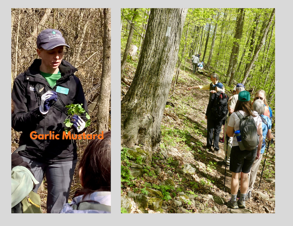
Double Day: hike and work party
https://hikes.brucetrail.org/event/double-day-hike-and-work-party/Sorry, the registration cut-off time for this hike has been reached.Not a member? Click here to join today!Trip Information
Departure Time: 09:30
Return to City Time: 17:00
Departure Point: York Mills Bus PickupOptional Items
Hosting Club: Toronto
Category: Bus Hike
Location (Google Maps): Halton HillsHike Leader(s): Janet Patterson; Monica Pasquali; George Lennon Click here to contact Hike Leader(s)
Pace: Leisurely (2-3 km/hr)
Terrain: Level 1 (Easy – mostly on flat, well maintained trails with hard-packed surface), Variable
Distance (km): approx 3 kmDescription
This outing is an experiment. It is a family-friendly event offering our members the chance to “give back”. NOTE: discounted bus fee ($20) and children accompanied by an adult ride the bus for free. Register your child/childern by selecting “add additional hiker” and adding their information (select “child” and no fare will be charged).The bus will deliver us to the trail head (Duff Pit), and on arrival, we will split into two groups. Group A will go off on a guided hike with members of the club’s Biodiversity Team, observing, identifying and perhaps even photographing the delightful flora and fauna we can discover. This will be a great way to gain points towards your Biodiversity Naturalist badge.
Meanwhile, Group B will learn to identify and pull out the invasive garlic mustard that is proliferating there. We will have members of the Land Stewardship team and BTC Conservation Ambassadors guiding and supervising us, so no previous experience is necessary!
We’ll meet back at the trail head for lunch, after which the groups will switch roles.
So everyone will get a chance to explore the trails AND contribute to stewardship activities that support our ongoing efforts preserve and enhance the natural ecosystems along the trail. There’s even a badge for this!
We hope you will support this new initiative.
What to bring (& wear):
- garden gloves if you have them
- Plenty of water (1L minimum)
- Lunch, snacks
- Sunscreen, insect repellent, wide-brimmed hat, long sleeves and long pants
- Sturdy shoes or boots
- A few reusable shopping bags if you have some
Geology Hike #6A Palisades
https://hikes.brucetrail.org/event/geology-hike-6a-palisades-2/Sorry, the registration cut-off time for this hike has been reached.Not a member? Click here to join today!Hosting Club: Sydenham
Category: Geology Hike
Location (Google Maps):Harrison Park Inn parking lot, 137 Second Avenue East Owen Sound
Hike Leader(s): Karen Buschert Click here to contact Hike Leader(s)
Pace: Leisurely: 3 km/h or less
Terrain: Moderate: Some hills and/or poor footing, Strenuous: Hilly with steep climbs and some poor footing., There might be muddy sections., There might be sections with water on the trail.
Distance: 6 km. approxDescription
This is part A of Geology Hike #6 (Palisades section) following Beth Gilhespy’s book “Walking Through Time” in the Sydenham Bruce Trail Section. You will be immersed in a wilderness of towering rock, talus boulders and thick tree cover. Scenic viewpoint from Raven’s Nest Sidetrail.
This is a balloon hike, starting from the parking lot at Harrison Park Inn, hiking north along the Harrison Park sidetrail up to 7th Avenue East access to the main trail and returning back on the Palisades side trail and back to our starting point.Please bring water and a snack if you wish. Proper hiking footwear and hiking poles are recommended.
Hunting Spring Ephemerals
https://hikes.brucetrail.org/event/hunting-spring-ephemerals/Sorry, the registration cut-off time for this hike has been reached.Not a member? Click here to join today!Hosting Club: Iroquoia
Category: General Hike
Location (Google Maps): Hilton Falls Conservation AreaHike Leader(s): Anne Armstrong Click here to contact Hike Leader(s)
Pace: Leisurely – 3km/hr or less
Terrain: Moderate – Some hills and/or some poor footing
Distance: Approx. 9 – 10 km.Description
Hilton Falls is a beautiful conservation area not only for its waterfalls but also the profusion of Spring Ephemerals which grow along its many trails. We’ll be on the hunt for late blooming Spring wildflowers. Please meet in the main parking lot of Hilton Falls Conservation Area located on Campbellville Rd. between Guelph Line and Highway 25 by 9:45 am. for a 10:00 am. start. Bring water, a snack, sunscreen and insect repellent. Hiking poles may be useful. A reservation is necessary to enter the area. Make it through Halton Parks. I will send out an email the day before the hike with my contact information in the event you need to cancel the morning of the hike.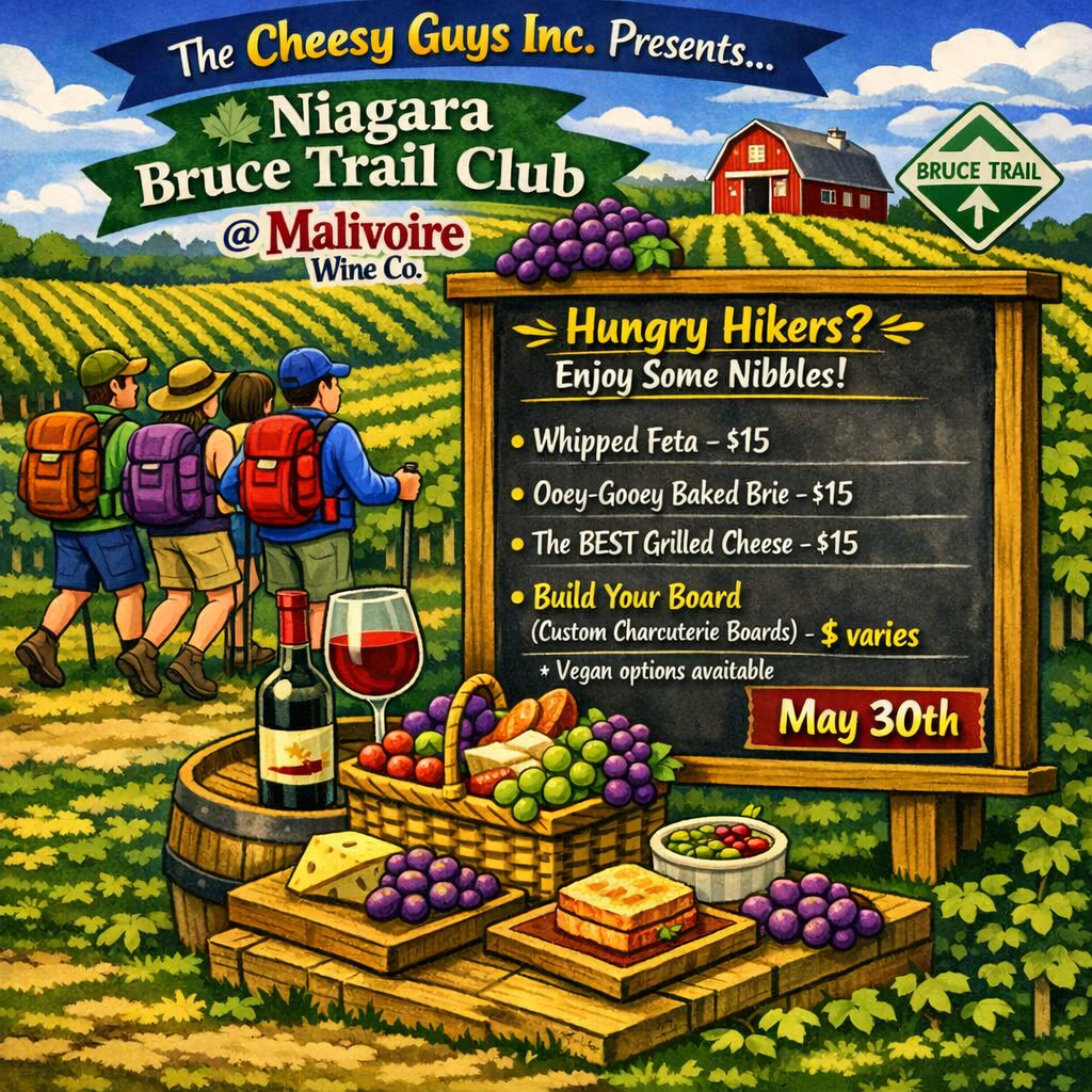
10:00 Malivoire Wine Co Hike and Wine Tasting Experience
https://hikes.brucetrail.org/event/1000-malivoire-wine-co-hike-and-wine-tasting-experience-3/Sorry, the registration cut-off time for this hike has been reached.Not a member? Click here to join today!Hike open to BTC Members only.
Hosting Club: Niagara
Category: Loop
Location (Google Maps): Park at Malivoire Wine Co 4260 King St, Lincoln ONHike Leader(s): Sam Rutherford Click here to contact Hike Leader(s)
Pace: Medium 3- 4 km/hr
Terrain: Moderate: some hills and some poor footing
Distance: 5 kmsDescription
We will hike a loop on the main trail from Malivoire Wine Co to the Margaret Reed Side Trail at Cave Springs Conservation Area and back to Malivoire Wine Co by 11:30. Upon return we will enjoy a private structured wine tasting led by one of the knowledgeable and friendly winery staff from 11:30 to 12:00 noon. The cost for the tasting experience is $15.00 per person (tax and tip included). Please bring your $15.00 with you as I will collect it prior to the tasting to simplify the payment to Malivoire Wine Co. Thank you.The Cheesy Guys are at Malivoire on the weekends so if you choose to enjoy some nibbles please check out the poster for some interesting selections and prices. Food is extra. You can find them on INSTAGRAM – https://www.instagram.com/thecheesyguysinc/
Habitat Restoration Project - Controlling the Spread of Garlic Mustard
https://hikes.brucetrail.org/event/habitat-restoration-project-controlling-the-spread-of-garlic-mustard/Sorry, the registration cut-off time for this hike has been reached.Not a member? Click here to join today!Hosting Club: Caledon Hills
Category: Habitat Restoration Project
Location (Google Maps): Meet at Mono 5 Sideroad Parking lot east of Airport Road 43.974055 – 79.984988From Airport Road, head east on Mono 5 Sideroad for approximately 1 kilometre. The parking lot is on the left side.
Hike Leader(s): Sandy Green Click here to contact Hike Leader(s)
Pace: Leisurely – 3 km/hour or less
Terrain: Easy – mostly flat and usually good footing
Distance: 2 kilometresDescription
Volunteers are needed to help control the spread of garlic mustard on two BTC Protected Natural Areas in the Hockley Valley East area. Join Land Stewards Bill and Sandy to pull the invasive species by hand or if you prefer bring a small trowel or dandelion weeder. Wear long sleeves and long pants. Pack gloves, sunscreen, insect repellent, a beverage, and a snack. The work is satisfying, and the camaraderie is always fun. All are welcome to help enhance biodiversity.