Click here for more information or to register
Hosting Club: Niagara
Category: Event Hikes
Location (Google Maps):
Port Dalhousie Heritage District, Public Parking
Hike Leader(s): Faye Perkins Click here to contact Hike Leader(s)
Pace: Medium
Terrain: Easy
Distance: 47 km
Description
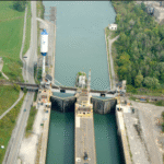
The Welland Canal is an engineering achievement that has shaped the economic and transportation landscape of the Niagara Region for two centuries, and it continues to be at the center of our ongoing development. Come celebrate the history of the Welland Canal as you hike, run, jog and/or walk From Port Colborne to Port Dalhousie,
This distance challenge, is a self-guided hike along a mainly paved trail. A map of the trail can be found at: http://niagarabrucetrail.club/wp/badges/ under the Merritthon badge
Fee: The entry fee includes Bus transporation to the start of hike, refreshments at the checkpoints, a badge and a donation to the Bruce Trail Conservancy in its mission to preserve a ribbon of wilderness, for everyone, forever.
BUS LEAVES AT 7:00 SHARP. Late arrivers will need to check in and make their own way to Port Colborne
Check in: At Port Dalhousie Parking Lot St Catharines from 6:40. Buses will transport hikers to Port Colborne.
Route: Follow the yellow blazes from Port Colborne to Port Dalhousie back to the parking lot
What to bring: Bring your own water and snacks. Wear comfortable sturdy shoes and dress for the weather.
Extra water and snacks will be available at the checkpoints.
FAQ’s
What if it rains? This is a rain or shine event.
What if I need to drop out? Trail Angels will be available at the checkpoints to drive you back to your car.
How long will it take to finish? We estimate that the hike will take between 8 and 9 hours. If you do not reach the last checkpoint by 3:30pm you will have to withdraw
Is my ticket/registration transferable/refundable? Yes. Refundable up to 30 days before the event but not transferrable. Please let us know if you cannot make it.
What if I want to run the course? If you intend to run the course, please send an email to Faye Perkins (below) so that we can ensure that we have volunteers in place early. Please ensure that you bring drinks and electrolytes.
Contact: Faye Perkins at faye.perkins7469@gmail.com 416 843 9274