
Scheduled Outage: Our website will be down for planned system upgrades for an estimated duration of Mon. Aug. 24, 7:00 pm - Tues. Aug. 25, 6:00 am.
Hike Schedule
Join us for a hike! Registration required.
All hikes available to BTC members. Some hikes are open to non-members.
See Refund Policy for Paid Hikes >
TIP: The calendar view displays up to 7 hikes on a day, but often there are more. Click “View more events” to see them all.
Niagara
Iroquoia
Toronto
Caledon Hills
Dufferin Hi-Land
Blue Mountains
Beaver Valley
Sydenham
Peninsula
All Clubs
Show Filters
Categories
Reset Filters
- 01November 1, 2026No events
- 02November 2, 2026
Dufferin Hi-Land Blues #4
https://hikes.brucetrail.org/event/dufferin-highland-blues-4/Hike open to BTC Members only.
REGISTRATION FULL: This hike has reached the maximum number of hikers.
Click here to be added to the Wait List.Hosting Club: Iroquoia, Dufferin Hi-Land
Category: General Hike
Location (Google Maps): Bruce Trail parking: 2nd Line EHS at the beginning of the Splitrock Side TrailHike Leader(s): Pati Greenwood, Jeff Dowsett Click here to contact Hike Leader(s)
Pace: Medium – 3 to 4 km/hr
Terrain: Moderate – Some hills and/or some poor footing, Strenuous – Hilly with steep climbs and some poor footing
Distance: 14 KMDescription
This is a series of five hikes in the Dufferin Hi-Land section of the Bruce Trail to complete all blue-blazed trails in the section. Hikers finishing all hikes in the series will be eligible to obtain the Dufferin Hi-Land Club’s Side Trails Badge. All hikes in the series will be loops including sections of the main trail and the entirety of several side trails.This fourth hike of the series will include completing the following side trails: Splitrock, Ralph Tremills, Narrows, 2nd Line EHS, Walter Tovell (north of Carriage), Lookout, & McCarsten’s Lake.
The trail will include steep and rocky sections, please wear appropriate footwear for the terrain; hiking boots or shoes. Hiking poles are recommended. Insects are not as active at this time of year; even so, come prepared by wearing long pants and long sleeves; bring insect repellent/bug nets as needed. Weather conditions can also be changeable so dress in layers, as needed. Bring plenty to drink and a snack/lunch.
Please arrive at the meeting place by 8:15 am for an 8:30 am departure.
- 03November 3, 2026
Split Rock/Walter Tovell/Lookout Side Trails
https://hikes.brucetrail.org/event/split-rock-walter-tovell-lookout-side-trails/
Registration Required:
Click here to register for this hike (25 spots remaining)Hosting Club: Dufferin Hi-Land
Category: Tuesday Hike
Location (Google Maps):Dufferin Hi-Land Section, Map 19. Meet at Split Rock parking lot on 2nd line EHS about 1.5 km north of 25 Sideroad
Hike Leader(s): Inge Eckerich, Julie Daley, Tony Evangelista Les Babbage Click here to contact Hike Leader(s)
Pace: Leisurely
Terrain: Moderate
Distance: Long hike 6 km, Short hike 3.7 kmDescription
Today’s hike will include the Split Rock, 2nd Line EHS Walter Tovell and Lookout Side Trails,short hike will only do Split Rock loop - 04November 4, 2026
Evening Hike in Owen Sound followed by an Opportunity for Refreshments
https://hikes.brucetrail.org/event/evening-hike-in-owen-sound-followed-by-an-opportunity-for-refreshments-25/
Registration Required:
Click here to register for this hike (99 spots remaining)Hosting Club: Sydenham
Category: An evening walk.
Location (Google Maps): Meet in the municipal parking lot by the river on the West side of 1st Ave East between 7th St East and 8th St East in Owen Sound.Hike Leader(s): Harriet Nixon Click here to contact Hike Leader(s)
Pace: Brisk: 4 to 5 km/h
Terrain: Moderate: Some hills and/or poor footing
Distance: Approx 6 kmDescription
Join us for a brisk evening walk exploring paths and neighbourhoods within the City limits of Owen Sound. Following the hike there is an opportunity to socialize over refreshments. There is no need to show up 15 minutes early for this hike, but we will leave promptly at 7:00 pm. - 05November 5, 2026No events
- 06November 6, 2026No events
- 07November 7, 2026
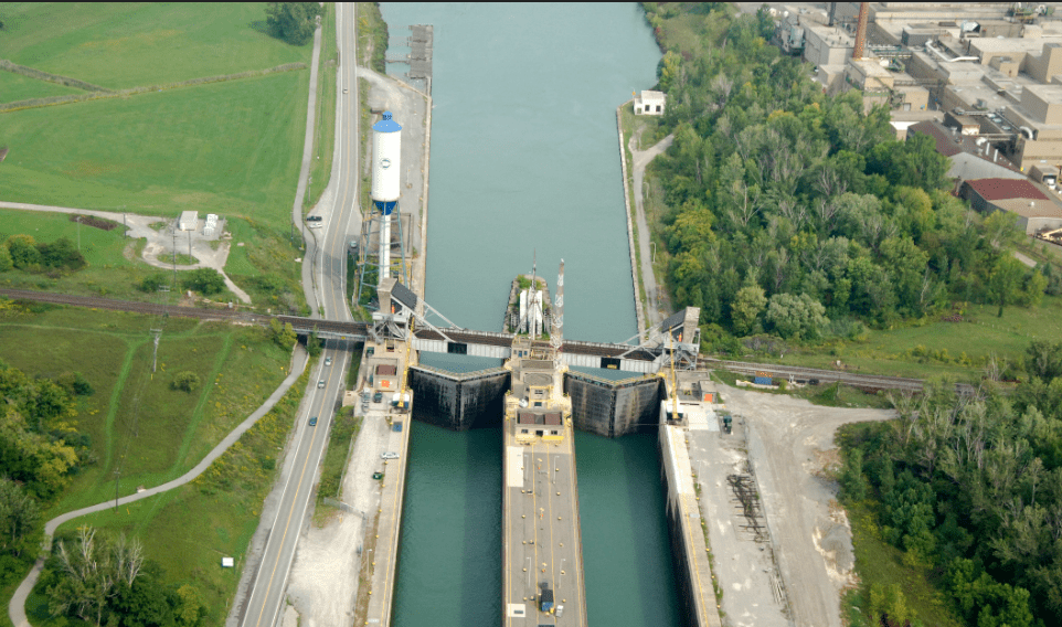
Merritthon
https://hikes.brucetrail.org/event/merritthon/
Registration Required:
Registration Costs
Members - $50.00
Child Members - $50.00
Non-Members - $60.00
Child Non-Members - $60.00
Click here to register for this hike (96 spots remaining)Hosting Club: Niagara
Category: Event Hikes
Location (Google Maps):Port Dalhousie Heritage District, Public Parking
Hike Leader(s): Faye Perkins Click here to contact Hike Leader(s)
Pace: Medium
Terrain: Easy
Distance: 47 kmDescription
The Welland Canal is an engineering achievement that has shaped the economic and transportation landscape of the Niagara Region for two centuries, and it continues to be at the center of our ongoing development. Come celebrate the history of the Welland Canal as you hike, run, jog and/or walk From Port Colborne to Port Dalhousie,This distance challenge, is a self-guided hike along a mainly paved trail. A map of the trail can be found at: http://niagarabrucetrail.club/wp/badges/ under the Merritthon badge
Fee: The entry fee includes Bus transporation to the start of hike, refreshments at the checkpoints, a badge and a donation to the Bruce Trail Conservancy in its mission to preserve a ribbon of wilderness, for everyone, forever.
BUS LEAVES AT 7:00 SHARP. Late arrivers will need to check in and make their own way to Port Colborne
Check in: At Port Dalhousie Parking Lot St Catharines from 6:40. Buses will transport hikers to Port Colborne.
Route: Follow the yellow blazes from Port Colborne to Port Dalhousie back to the parking lot
What to bring: Bring your own water and snacks. Wear comfortable sturdy shoes and dress for the weather.Extra water and snacks will be available at the checkpoints.
FAQ’s
What if it rains? This is a rain or shine event.
What if I need to drop out? Trail Angels will be available at the checkpoints to drive you back to your car.
How long will it take to finish? We estimate that the hike will take between 8 and 9 hours. If you do not reach the last checkpoint by 3:30pm you will have to withdraw
Is my ticket/registration transferable/refundable? Yes. Refundable up to 30 days before the event but not transferrable. Please let us know if you cannot make it.
What if I want to run the course? If you intend to run the course, please send an email to Faye Perkins (below) so that we can ensure that we have volunteers in place early. Please ensure that you bring drinks and electrolytes.
Contact: Faye Perkins at faye.perkins7469@gmail.com 416 843 9274
Car Hike: Erindale park
https://hikes.brucetrail.org/event/car-hike-erindale-park/
Registration Required:
Click here to register for this hike (25 spots remaining)Hosting Club: Toronto
Location (Google Maps): Erindale park parking lot
Hike Leader(s): MOHAMMAD AGHAMIRI Click here to contact Hike Leader(s)
Pace: Moderate (3-4 km/hr)
Terrain: Hilly, Level 2 (Intermediate – some hills and uneven surfaces, rocks and roots underfoot), Variable
Distance (km): 14-15 kmDescription
We will hike Credit River North and will see nice views of Credit River and possibly some salmons heading upstreamFrom parking lot we hike north mostly along Credit River and return to parking around 13 to 13.30
For the day of hike only my phone number is 289 588 6482.
Beaver Valley Geology Hike Badge #7/8 Wodehouse Karst Northern Route
https://hikes.brucetrail.org/event/beaver-valley-geology-hike-badge-7-8-wodehouse-karst-northern-route/
Registration Required:
Click here to register for this hike (14 spots remaining)Hosting Club: Blue Mountains
Category: Organized Hike
Location (Google Maps): Tim Horton’s, First Street, CollingwoodHike Leader(s): Annette Sandberg Click here to contact Hike Leader(s)
Pace: Leisurely – 3 km/hr. or less
Terrain: Moderate – Some hills and/or some poor footing
Distance: 5 kmDescription
Wodehouse Karst (Northern Route): Barn Foundation on Stone Foundation Side Trail at Stop 6 (Pages 95- 97) Barn Foundations are wonderful places to see many different rock types, including the Escarpment’s Fossil Hill Dolostone layer, which is full of coral and other fossils.
See Hike #1 – August 26 for series description