Pace: Brisk (4-5 km/hr), Moderate (3-4 km/hr) Terrain: Hilly, Level 2 (Intermediate – some hills and uneven surfaces, rocks and roots underfoot), Variable Distance: Fast group 16 to 18 km, Moderate group 13 km
Description Join us for a fantastic fall hike in the Dufferin Highlands (Map 20). Enjoy awesome views from Murphy’s Pinnacle and the Mulmur Lookout.
We will split into two groups. The fast group will do the Primrose Loop Side Trail and then follow the main trail north to km 29.6 (about a 16 km hike). If time permits the fast group will also do the Rock Hill Park Side Trail. The moderate group will head straight to Murphy’s Pinnacle and follow the main trail north to km 29.6 (about a 13 km hike).
Pack water, lunch, sun and rain protection.
Refreshment stop in Primrose if time allows.
Bus departs at 8:30 am from 10 York Mills Rd. We hope to be back in the city by 6 pm.
Pace: Medium Terrain: Slippery and Steep Sections, Strenuous Distance: 15 Km approximately
Description Hike 3 of this hills series. We will meet at the 1st Line parking lot then car pool back to Centre road. From there we will hike on the main trail down to the Boyne Valley Side Trail. We will return to the main trail and enjoy all the hills and valleys the Boyne area offers. Once we return to the 1st Line parking lot we have the option to explore the Rock Hill side trail before returning to the cars. Please wear hiking shoes or boots, bring snacks/lunch and water. Dress for the weather. Note the hike leaders will have 2 dogs on this hike. This hike involves challenging climbs and is recommended for experienced hikers only.
Description Meet in the Mountainview Conservation Area (CA) parking lot and hike to Grimsby Point Bluff (Beamer Memorial CA). After a short break, we will retrace our path.
This section of the trail has some steep, technical ascents and descents. We will be rewarded with some beautiful lookout points.
Consider your fitness level before registering. Everyone is expected to keep up with the person in front of them for the duration of the hike.
Dress for varying weather conditions. Hiking poles and boots are highly recommended. Bring fluids and a snack.
Plan to arrive at the start point by 8:45 as we will leave at 9:00 sharp.
Hosting Club: Toronto Category: Car Hike Location (Google Maps): KM83.5. Roadside parking on Guelph Line
Hike Leader(s): Alina Lin
Pace: Brisk (4-5 km/hr) Terrain: Level 2 (Intermediate – some hills and uneven surfaces, rocks and roots underfoot) Distance: 21 km
Description Let’s make this hike extra fun with a Halloween theme! You’re encouraged to dress up as whoever you want to be and enjoy a festive walk in the forest. Just remember — no matter what your costume is, sturdy hiking footwear is a must!
This is the 6th hike of an End-to-End series covering the entire Iroquoia Bruce Trail section. The full section stretches over 120 kilometers from Grimsby to Milton. I am using Map Edition 29 to plan the hikes, and so please note that kilometer markings may not be fully up to date, and actual hiking distances may vary slightly.
Meeting Point: KM83.5. Roadside parking on Guelph Line, south of No. 1 Sideroad. GPS: 43.388387, -79.854327. Please arrive before 8:45am to allow time for car shuttle coordination.
We will car shuttle to 103.8KM Roadside Parking on Twiss Rd North of Derry Rd. GPS: 43.447743, -79.953436. From there to hike back to KM83.5.
All drivers are expected to participate in the car shuttle, either before or after the hike. All hikers are expected to chip in for parking fees, if applicable.
Important Notes:
Wear sturdy hiking footwear and dress appropriately for the weather
Pace: Medium (3.0 – 4.5 km/h): A comfortable pace for most hikers with steady progress. Terrain: Difficult: Steep ascents/descents, rocky scrambling, and some rugged escarpment paths., Moderate: Rolling hills, mild slopes and rocky paths. Distance: ~11 km
Description We invite you to join us for this fun “figure 8” hike which includes five side trails! We will hike on the sidetrails of White Bluff Provincial Nature Reserve and along the beautiful escarpment overlooking Georgian Bay and Lion’s Head Harbour. This hike twists and turns like a sidewinder through quiet meadow, mixed forest and rocky ups-and-downs!
Bring your lunch or snack for a brief stop at Reed’s Dump. Duration of the hike will be ~ 3 1/2 hr. Portapottie available at the Forty Hills parking lot and basic outdoor toilet available at Reed’s Dump.
Sturdy footwear with good grip is recommended. Good balance and endurance are required.
Free coffee and muffin for hike participants arriving by 9:15 a.m.
Pace: Medium – 3 to 4 km/hr Terrain: Moderate – Some hills and/or some poor footing Distance: 14 km
Description Come by car or transit for this all-inclusive 2SLGBTQI+ friendly Rainbow hike from Smokey Hollow Waterfall, Waterdown to Waterdown Woods and beyond.
Please arrive at the Smokey Hollow parking lot, 80 Mill St. South, by 9:15 a.m. for a 9:30 a.m. start.
This is the same starting point as our October 13th hike—but we’ll be exploring in the opposite direction. (Ideal for anyone planning to complete their E2E).
Today’s 14 km in-and-out hike follows the Bruce Trail Main Trail with detours alongKing Side Trail, Ian Reid Side Trail, and if time allows we’ll aim for one of the International Friendship Trails.
By transit to the starting point. The easiest route is to take HSR transit or GO Bus (depending where you live) to Aldershot GO station, then hop on the 18 Leavitt Loop bus and get off at “Mill St. at Mountain Brow,” a 3-minute walk to the Smokey Hollows parking lot. The bus drivers on this route are accustomed to hikers.
By car: There is unpaid parking at Smokey Hollow, which can fill up early. If lot is full: There’s street parking on Flanders Drive, about a 15-minute walk to Smokey Hollows. PLEASE allow yourself enough time to sort out your parking so you can arrive at Smokey Hollows parking lot by 9:15 a.m latest.
Post-hike refreshments: The Royal Coachman in Waterdown has long been hiker-friendly.
Bring 1 litre of water and lunch. (Since it’s November, a thermos of something hot wouldn’t go amiss. Hiking boots or sturdy footwear are recommended. Dress in layers. Always bring some kind of rain gear. Yup, it’s that time of year 🙂
Get your complimentary Bruce Trail Rainbow badge and/or sticker at the end of the hike!
Feel free to reach out to the Hike Leader if you have any questions – “Click here to contact Hike Leader” on this form.
Pace: Moderate (3-4 km/hr) Terrain: Level 1 (Easy – mostly on flat, well maintained trails with hard-packed surface) Distance: 8.5 km
Description From Victoria Park subway we shall walk northeast along the Taylor Creek to the Don River, follow the West Don River to Sunnybrook Park. At Sunnybrook Health Centre on Bayview Ave is TTC #11 bus that connects with Davisville subway station and TTC #124 bus that connects with Lawrence subway.
We shall have a picnic halfway so bring a sandwich and a thermos.
Check your email at 8AM on day of hike to verify hike status.
Hosting Club: Caledon Hills Category: General Location (Google Maps): Meet at the main gate entrance. Park roadside near the gate. Please do not drive into the park past the main gate, as we are starting out on the loop from this point. The park address is 14125 11th Concession, King (near Nobleton). The GPS coordinates will lead you into the park past the main gate. Please aim to arrive at 10:15 am for a 10:30 am start. Thanks! Note: Because of construction on 11th Concession, take 11th Concession going south to reach the conservation area. You cannot go north on 11th Concession from King Road.
Pace: Leisurely – 3 km/hour or less, Medium – 3 to 4 km/hour Terrain: Easy – mostly flat and usually good footing, Moderate – some hills and/or some poor footing Distance: Approximately 6 km
Description Looking to get out on a Saturday but not give up your whole day? Saturday Shorts, a hiking series, will get you out in a small group on a short hike. This Saturday’s hike is an enjoyable one in any season. We’ll hike the outer loop, making about a 6 km route, at Cold Creek Conservation Area. Things to consider in your hike preparations: warm gear/dressing in layers, hiking shoes/boots, poles, water, a snack. There will be a short break. No dogs please. Registrants can expect a reminder/update message one or two days before the hike.
Hosting Club: Toronto Category: Car Hike Location (Google Maps): We will meet at the larger parking lot in Woodend Conservation Area, 1 Taylor Rd, Niagara-on-the-Lake, ON L0S 1J0 (coordinates: 43.150276, -79.155092).
Pace: Leisurely (2-3 km/hr) Terrain: Level 1 (Easy – mostly on flat, well maintained trails with hard-packed surface), Level 2 (Intermediate – some hills and uneven surfaces, rocks and roots underfoot) Distance: 8 km total, divided into two hikes of 4 km each
Description Calling all hikers who love Halloween and working on badge requirements!
Today we will complete two of the three required hikes for the Niagara Bruce Trail Club’s Screaming Tunnel Badge. First, we’ll complete a 4 km out-and-back hike along the main Bruce Trail from Woodend Conservation Area to the “Screaming Tunnel” – please wear/bring your Halloween costume/hat for a photo op which is one of the requirements for the badge. Then we’ll all hop into our cars and drive about 11 km west to DeCew House Heritage Park, stopping for lunch along the way. After parking at DeCew House Heritage Park (address: 2370 DeCew Rd, Fonthill, ON L0S 1E6; coordinates: 43.107568, -79.249598) we’ll complete another 4 km out-and-back hike, but this time along the Bert Lowe Side Trail in order to visit another tunnel which is another requirement for the badge.
Youth who are 15 years of age and under are encouraged to join their parents/guardians on this hike so they can also fulfill the requirements for the Niagara Bruce Trail Club’s Youth Hiking Badges. The Young Trail Blazer Badge simply requires the completion of one hike on the Niagara Bruce Trail, which our young participants will earn by completing today’s hikes. The Young Nature Blazer’s Badge requires our young participants to pay attention to what they see and hear during today’s hikes and then complete a write-up describing what they observed. Please note that all family members who are planning on joining us should register for the hike, including children.
All hikers who register for today’s outing should bring water and snacks, comfortable hiking shoes, appropriate clothing for the weather, and payment for lunch if you intend to join us for lunch at a restaurant (e.g., Harvey’s).
Information about all Niagara Bruce Trail Club badges can be found here: https://niagarabrucetrail.club/badges/ Please note that you will have to complete the third hike required for the Screaming Tunnel Badge by joining a “Witch of Cave Springs Hike” organized by the Niagara Bruce Trail Club in October/November, so keep an eye on the BTC hike schedule so you don’t miss your opportunity to do this: https://hikes.brucetrail.org/
Pace: Leisurely (2-3 km/hr) Terrain: Level 1 (Easy – mostly on flat, well maintained trails with hard-packed surface), Variable Distance: 10K
Description Come join me for a 10K urban hike starting in Georgetown and learn about the area’s unique history in Glen Williams. Those leaving from Toronto can hop on the “Kitchener Line” Go Train at Union Station (at 9:48 am) or Bloor Go Station (at 9:58 a.m.). or Weston Go Station (10:07 a.m.) to arrive in Georgetown Go Train Station at 11:08 am (you’ll transfer to bus at Mt Pleasant Station in Brampton – a 20 minute stopover – for the rest of your journey). The return bus/train from Georgetown leaves at 3:07 p.m. There is a 15-minute stopover at Mount Pleasant Station on the return trip. You’ll be back at Union Station at 4:35 p.m.
If you wish, you can also drive to the Georgetown Go Station (north parking lot) for the hike. GPS: 43.656030, -79.919159.
The 2.5 hour hike will take us to the ruins of the historic Barber Mill (first site of hydro power in Ontario), then we will follow along the Credit Valley Footpath to the quaint town of Glen Wiliams (established 1825), with a chance to see artisan workshops and purchase sweets at Kits Kitchen or tea at the Main Street Market. After viewing some historic homes in the village, we will make our way back to Georgetown, following an abandoned rail line that takes us to the Georgetown Train Station, built in 1885. We’ll wander past more historic homes and finish (depending on timing) with a stop at Furnace Room craft brewery (across from the Station),
This is a Level 1 (easy) hike with a easy/moderate pace, suitable for “fit” beginners. There are some hills and depending on the weather, there could be wet areas along the Credit River footpath. Dress for the time of year, bring hiking boots, poles if you wish, water, sunscreen and lunch/snacks. Go Transit weekend day passes are available online for $10. Limit: 14 Hikers
Pace: Moderate (3-4 km/hr) Terrain: Flat, Hilly, Level 2 (Intermediate – some hills and uneven surfaces, rocks and roots underfoot), Variable Distance: 13-14 km
Description Join us for a wonderful hike in Jefferson Forest and have a snack/lunch beside the Bond Lake. We will hike among tall trees and bushes of the Jefferson Forest and across the Bayview-Yonge corridor to reach to the Bond Lake. Boots mandatory, poles recommended, bring at least 2L of water, bug spray, sunscreen, snack/lunch and dress according to the weather conditions. Please avoid parking along the road. Difficulty Level: 2 (Moderate)
Please arrive @7:45 AM for start of 8:00AM.
This is a joint hike with the Oak Ridges Trail Association (ORTA).
Hosting Club: Caledon Hills Category: General Location (Google Maps): WE WILL BE PARKING AT THE NORTHERN PART OF THE PARK ON DUNBY RD. – NOT AT THE MAIN PARKING LOT. Roadside parking on the south side of Dunby Rd. at km 67.8
Pace: Medium – 3 to 4 km/hour Terrain: Strenuous – hilly with steep climbs and some poor footing Distance: 16 km
Description Join us for a 16 km hike through the Nature Reserve, known for being one of the most challenging and hilly sections of the Bruce Trail. Get ready for a workout.
We will be hiking at a moderate-fast pace. Please bring plenty of water and snacks. HIKE BEGINS AT 8:30 AM.
We are committed to providing an inclusive and welcoming environment. This hike is an 2SLGBTQIA+ safe space, and everyone is welcome to join us!
Hosting Club: Dufferin Hi-Land Category: General Hike Location (Google Maps): Off road parking located on a very short dirt road off Winston Churchill Blvd just south of the Main Trail. North of entrance to Terra Cotta CA at top of hill. Busy Road and blind corner. Please be careful. See Google Maps link for GPS.
Pace: Medium Terrain: Slippery Sections Likely, Moderate Distance: 14 kms
Description Join us on a four-hike end-to-end hike series covering the Toronto Section plus a few kilometres up to The Grange. Today’s hike is the third of that shuttle series. We will make our way on the Main Trail from Scotsdale Farm to Terra Cotta. Please bring 1.5L of water, a snack, a lunch, and a smile. Please also bring footwear to change into after the hike and a garbage bag to put your boots in for the shuttle. Hiking boots mandatory. Poles very much recommended. It will be quite rocky in sections. Please arrive at 9 am and be ready to shuttle at 9:15 sharp.
Pace: Medium – 3 to 4 km/hr Terrain: Moderate – Some hills and/or some poor footing Distance: 9 kms
Description A new way to hike the Speyside trails, we’ll meet roadside on Fourth Line at 9:15 am and hike the main trail to the Canada Goose ST and onto the Charles Hildebrandt ST to the “unassumed road” and into Speyside from that end. Hiking around the Cliff Hatch ST and main trail back to Fourth Line. There are some very rocky sections along these trails. Bring water and a snack. Hike is dependent on weather conditions.
Hosting Club: Dufferin Hi-Land Category: General Hike Location (Google Maps): Meet at Mono Centre Community Centre to hike in the Mono Cliffs Provincial Park
Description Why are there cliffs in the park? Are there any fossils? This leisurely hike will make many stops to look at rocks and talk about the landscape of the area. Don’t forget to bring your camera.
We will use several side trails, mostly the Walter Tovell and South Outlier Trails, to visit the north and south Outlier exposures.
Please wear sturdy footwear as there are hills and stairs. Pack water, snacks and dress for the weather.
Location (Google Maps): Parking lot at the top of the hill in Dyers Bay
Hike Leader(s): Beige McIntosh
Pace: Leisurely (2.0 – 3.0 km/h): A relaxed pace with frequent breaks and a focus on enjoyment. Terrain: Moderate: Rolling hills, mild slopes and rocky paths. Distance: 3.5 km
Description Join us for the final hike in the Mindfulness Hike series. On this hike we will hike a loop along the escapement which includes the Anne & Clayton Roberts Side Trail. We will move at a leisurely pace.
To assist us in quieting our minds, this will be an unplugged hike, meaning you will be required to leave your phone behind but the hike leader will bring a (powered off) cellphone in case of emergency. We will begin with a sensory meditation and hike in complete silence for most of this hike. Depending on the weather we may hike without shoes as a means of connecting more deeply with our bodies and the ground beneath us.
Everyone is welcome, no prior meditation or hiking experience necessary. To allow time to slow down mindfully, we will be out for approximately 2 hours.
Hosting Club: Niagara, Iroquoia Category: General Hike Location (Google Maps): Parking Area off Roland Road, providing immediate access to the Short Hills Provincial Park’s Paleozoik Path.
Pace: Medium – 3 to 4 km/hr Terrain: Moderate – Some hills and/or some poor footing Distance: 12.4 km
Description This is an End-to-End hike series to complete the Niagara section of the Bruce Trail in 6 hikes. Join for all or as many hikes as desired.
This third hike of the series starting at Decew House will take us around Lake Moodie, past Decew Falls and through Short Hills Provincial Park.
Weather conditions in the fall can be changeable, so it’s best to dress in layers and come prepared for varying conditions throughout the day. Insects, particularly ticks, are still active in the fall months, so take appropriate precautions to avoid them including using repellant and wearing clothing that covers the legs and arms. Hiking boots are required and hiking poles are recommended.
Bring plenty of fluids, including electrolytes, and a snack.
Since this is a group hike, please consider your fitness level before registering. We will be walking at a pace of 3km – 4km per hour and everyone is expected to keep up with the person in front of them for the duration of the hike.
Plan to arrive at the meeting place by 8:15 a.m. as we will start the car shuffle to the hike starting point at 8:30 a.m. sharp. Further details will be provided to registered hikers a few days prior to the hike.
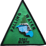
Hosting Club: Iroquoia, Dufferin Hi-Land Category: General Hike Location (Google Maps): Meet at BTC parking lot located off 15 Sideroad, 40 metres west of Prince of Wales Rd and we will shuttle to Lavender to begin our hike
Pace: Brisk – 4 to 5 km/hr Terrain: Strenuous – Hilly with steep climbs and some poor footing Distance: 17.1
Description Hike the challenging Dufferin Hi-Lands section 56 kms over 3 days. We will meet each morning at 7:45 and be ready to shuttle at 8:00. Hikers will take turns shuttling and taking drivers to their cars each day.
Hikers should wear layered clothing, hiking boots, poles, hat, sunscreen, bug spray, rain gear and bring plenty of water, snacks and lunch. We will hike rain or shine.
Full itinerary will be emailed to hikers the week before the first hike.
Hosting Club: Toronto Category: Urban Walk Location (Google Maps): Parking lot is off Sycamore Drive East of Bayview , across Starbucks plaza Bus 91 from Finch east station stops at Sycamore station.
Pace: Moderate (3-4 km/hr) Terrain: Hilly, Level 2 (Intermediate – some hills and uneven surfaces, rocks and roots underfoot) Distance: 7-8 km
Description We will explore Valleyview and Maple View parks, and walk along German Mill Creak, in return we stop in Huntington park and have snack under beautiful shed ,
Even it is considered Urban walk, it is urban hike as we have some up and down hills and tree roots, please bring your hiking poles, water and snacks,
Hosting Club: Caledon Hills Category: Tuesday Hikers Location (Google Maps): Park at 8th Line, across from 8th Line Side Trail connecting with Great Esker ST. Driving directions: From Highway 401, north on Trafalgar Road, it will merge with Highway 7 – turn left and continue on Highway 7, turn right on Sideroad 22 (at Esso), left on 8th Line to road-side parking.
Pace: Medium – 3 to 4 km/hour Terrain: Moderate – some hills and/or some poor footing, Strenuous – hilly with steep climbs and some poor footing Distance: 12 km
Description BEAUTY OF FALL COLOURS: Will hike Main Bruce Trail and side trails in Silver Creek area, Great Esker, Irwin Quarry and Roberts ST. – bring water and snack. – poles recommended. – dress for chilly weather.
Optional refreshment stop after hike at Main Market or other place in the area.
Pace: Medium – 3 to 4 km/hr Terrain: Strenuous – Hilly with steep climbs and some poor footing Distance: 10km +
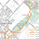
Description This 10.5 km hike will follow the main BT along the edge of the escarpment for great views of the Skyway bridge , Lake Ontario and surrounding area. We will continue to the outskirts of Waterdown and down into/out of the Grindstone Creek via the McNally and Waterdown Rd Side trails and main BT. Please dress in layers and bring water and a snack. Icers may be necessary.
(Google Maps) Blue Mountain Section, Map 21. Meet at roadside parking at Km 54.9 on Mulmur-Nottawasaga Townline, 550 metres east of Lavender Hill Road at the cemetery at 9:30 am or at the SuperBurger parking lot (north-west corner of Hwy 89/Hwy 10 intersection) for car pooling at 9:00 am.
Pace: Leisurely Terrain: Dependent on Conditions, Moderate Distance: Long Hike 6.6 km Short hike 4 km
Description From the Lavender cemetery, we will shuttle to roadside parking on County Rd 9 at Km 6.1. We will then hike back through the scenic Noisy River Provincial Nature Reserve to the small, but historic, village of Lavender, where the Dufferin Hi-Land Section ends. The shorter hike will turn around and return to County Rd 9 parking after about 2 km. Bring water and snacks. Hiking poles are recommended.
Pace: Medium Terrain: Moderate Length of Hike: 6.5 kms
Description This hike takes us through a long stretch of forest protected by the Grey Sauble Conservation Authority and by the BTC. There are some crevices in rock to be seen here. A good walk in the woods. Once we reach the 7th Line, we return on the same route.
Guidelines
Arrive 15 minutes before the start of the hike.
Wear sturdy footwear and appropriate attire for the weather and the terrain. Hiking poles are a good idea in any season, especially if the terrain is rocky or slippery. In winter, snowshoes or icers/crampons are needed when conditions dictate. Wearing appropriate clothing and footwear prevents injuries and shows consideration for a safe and positive group hiking experience.
Always carry I.D. and your health card.
Bring sufficient water and snacks (or lunch if indicated). A minimum of 1L of water is recommended on all hikes, and 3L is recommended for long, challenging hikes in the heat of the summer.
Bring sunscreen and insect repellent (for spring and summer hikes).
Pace: Medium – 3 to 4 km/hr Terrain: Moderate – Some hills and/or some poor footing Distance: 7 kms
Description We will meet in the Hilton Falls Parking lot and carpool to 6th Line and hike back along the two Bent Rim trails and the Hilton Falls Side Trail back to the cars. The Bent Rim trails are actually bike trails and have some rather technical (rocky) sections to them, so be prepared for some challenges.
For those leaving their car at Hilton Falls, you will need to reserve your time at conservationhalton.ca
Pace: Medium – 3 to 4 km/hr Terrain: Moderate – Some hills and/or some poor footing Distance: About 9km
Description Meet at about 9-45a.m. for a 10-00 a.m.start.
Our route will take us through some of the most interesting parts of Old Dundas. We then pickup the Spencer Creek trail system and enjoy an easy walk down to Centennial Park the Desjardins Canal and the Urquhart Butterfly Garden.
We reach Lake JoJo and then the Delsey Ponds on trails of use. Our route takes us through a pleasant subdivision then steeply up through Grove Cemetery and down to the Driving park where we started.
Bring a lunch, warm clothes and footwear for possible muddy sections. Pub stop afterwards if you like.
Pace: Leisurely (2.0 – 3.0 km/h): A relaxed pace with frequent breaks and a focus on enjoyment. Terrain: Easy: Flat forested sections or lowland trails. Distance: 2-3km
Description 🌕 Full Moon Hike Series: Part 2 of 7 🌕
Join us for a captivating evening hike along Ginebek Miikaans – the Snake Trail Boardwalk on the sacred land of the Chippewas of Nawash.
Your Anishinaabe guide Caley Doran will introduce us to the natural and cultural wonders found along Ginebek Miikaans – the Snake Trail Boardwalk. Miikaans is part of the Bruce Trail that is located along the shoreline of Wiikwedoonse (Sydney Bay) in the unceded Anishinaabek territory of Neyaashiinigmiing. This trail winds through mixed forest, to the edges of an active beaver dam and lodge, and along the shoreline of Sydney Bay. During this exploration you will learn about the traditional plants and wildlife that play a pivotal role in the traditional and contemporary lives of the Anishinaabek people. There are two very nice lookouts to take in the natural beauty of Sydney Bay and a beaver pond.
You can learn more about the traditional Anishinaabek teachings from time immemorial. Visit the Cape Croker Park website for more information on their Anishinaabe Cultural Experiences.
Caley Doran is a passionate hike leader, educator, and storyteller with a deep commitment to reconnecting people with the land through Indigenous knowledge and perspectives. Caley weaves together ecological understanding , Anishinaabe history, and personal reflection to guide meaningful outdoor experiences.
Date: Wednesday November 5th
Time: 6:00 pm
Moonrise: 4:51 pm This Full moon is known as “Beaver Moon” or “Freezing Moon” (It will also be a Supermoon)
Sunset: 5:11 pm
Hike length: 2-3 km
Duration: 2 hours
Location: Neyaashiinigmiing, Cape Croker Park, 112 Park Road, Wiarton.
Where to Meet: Cape Croker Park Beach Parking Area
Badge Alert:
New this year – earn a Full Moon Hiking badge by joining 4 of the 7 hikes in this Full Moon Hiking Series.
What to bring:
Illuminate the path with a red light headlamp (if you don’t have one that’s ok).
Sturdy boots
Appropriate clothing for the weather conditions (layers are great)
Something to sit on, snack, water or hot beverage
Don’t miss this opportunity to connect with nature and enjoy the night sky! We hope for clear skies to make the evening even more special.
Full Moon Hiking Series
Monday, October 6th – Cape Chin: Hike & History
Wednesday, November 5th – Cape Crocker (posted) Supermoon
Saturday, December 6th – Black Creek Provincial Park Supermoon
Note: Jan – Apr hikes will start being posted in December
Hosting Club: Sydenham Category: An evening walk. Location (Google Maps): Meet in the municipal parking lot by the river on the west side of 1st Ave E between 7th St E and 8th St E in Owen Sound
Pace: Brisk: 4 to 5 km/h Terrain: Moderate: Some hills and/or poor footing Distance: Approx 6 km
Description Join us for the Beaver Full Moon evening hike exploring Owen Sound paths and neighbourhoods, followed by an opportunity for refreshments. There is no need to show up 15 minutes early for this hike, but we will leave promptly at 7:00 pm.
Location (Google Maps): Parking lot is off Sycamore Drive East of Bayview , across Starbucks plaza Bus 91 from Finch east station stops at Sycamore station.
Pace: Moderate (3-4 km/hr) Terrain: Hilly, Level 2 (Intermediate – some hills and uneven surfaces, rocks and roots underfoot) Distance: 7-8 km
Description We will explore Valleyview and Maple View parks, and walk along German Mill Creak, in return we stop in Huntington park and have snack under beautiful shed ,
Even it is considered Urban walk, it is urban hike as we have some up and down hills and tree roots, please bring your hiking poles, water and snacks,
Pace: Medium Terrain: Some rocky footing, Some steep sections Length of Hike: Varies – each hike approx 18 km
Description This will be my final Stained Glass Badge hike series for 2025. We will complete an end to end of the Caledon section in 4 hikes. The hikes will be (1) Boston Mills in the Toronto Section to Willoughby Road, (2) Willoughby Road to Coolihans Sideroad, (3) Coolihans Sideroad to 4th Line EHS and (4) 4th Line EHS to Mono Centre. Please contact the hike leader for the detailed hike plan.
The hikes will proceed at a moderate pace (approx 4 km per hour not including a lunch stop). Breaks will be taken throughout each hike as appropriate. Hikes will proceed rain or shine.
Except for shuttles, hikers are expected to be self reliant. Please bring everything you may need such as water, lunch, snacks, personal medical kit, and appropriate footwear and clothing. All participants will be expected to share equally in the shuttle driving. Shuttle drivers should not expect compensation for driving. Drivers will be selected by the hike leader at the start of each hike.
Participants will be expected to sign a waiver in favour of the hike leader similar to the one in favour of the BTC they are required to submit on registration.
If there are any questions please contact the hike leader.
Description This will be our permanent Thursday Location until Bridge repairs complete. From Cave Spring Conservation Area explore the trail network on the escarpment towards Kinsman Park and Moyer Road.
You must register for each hike. Bring Poles, snack and a drink. Dress for the weather
Pace: Leisurely – 3km/hr or less Terrain: Moderate – Some hills and/or some poor footing Distance: Approx. 9 km.
Description Meet in the Bruce Trail Parking lot at Scotsdale Farm off of Trafalgar Rd. Look for the small sign. It is easy to miss. Barring a film shoot we should be able to park in the main lot. Meet at 9:45 am. for a 10:00 am.start. Bring water, a snack and sunscreen. We will head west on the main trail to Highway 7 where will will switch to Duff Pit Side Trail and go past the old graver pit until we join onto the Reservoir Trail to take in the old Georgetown reservoir. There are some rocky areas along the trail but generally it is easier terrain. I will send out an email with my cell phone number a couple of days before the hike should you need to cancel the morning of the hike.
Hosting Club: Iroquoia, Caledon Hills Category: General Hike Location (Google Maps): Meeting Place – Roadside Parking on Innis Lake Road, north of Finnerty Road
Pace: Medium – 3 to 4 km/hr Terrain: Dependent on Conditions, Moderate – Some hills and/or some poor footing, Strenuous – Hilly with steep climbs and some poor footing Distance: 15 km
Description This is an end-to-end hiking series to complete the Caledon section of the Bruce Trail in 5 hikes.
The hikes will be undertaken at a medium pace of approximately 4 km/hour for approximately 15 kms each hike. Please consider your fitness level before registering; this is a group hike, and everyone is expected to keep pace with the person in front of them for the duration of the hike.
The weather can be changeable at this time of year, so dress in layers for any possibility. There here are many steep and hilly segments in this section of the Bruce Trail so the hikes will require considerable stamina. Wear hiking boots and bring hiking poles. Bring a snack, plenty of water and other hydration as needed.
We will be travelling from south to north over the course of the End-to-End. The series will require car shuffles, and everyone will be expected to participate as drivers.
Today’s hike, the second of the series, is 15 km in length. Please plan to arrive at the meeting place by 8:15 am as we will start the car shuffle at 8:30 am sharp.
Further details will be provided to registered hikers a few days prior to the hike.
Hosting Club: Caledon Hills Category: General Location (Google Maps): Volunteers will park at the Badlands parking lot on Old Base Road. GPS coordinates are: 43.775829 and -79.942703
Pace: Leisurely – 3 km/hour or less Terrain: Moderate – some hills and/or some poor footing Distance: This is a restoration habitat work party
Description Our Club is now maintaining the section of main trail that goes through the Badlands.
Earlier this year, volunteers worked for days to improve the main trail with limestone/gravel to eliminate muddy sections and ensure the trail is satisfactory for the many visitors to this section.
On Friday, November 7th from 9:00 a.m. to 12:00, volunteers are needed to assist with removing the invasive species of buckthorn and prune back the larger buckthorn trees.
Volunteers will be provided with “extractigators” but, please bring your own loppers if you have some.
Bring gloves, water, snacks etc for yourself.
Volunteers will park at the Badlands parking lot on Old Base Road. GPS coordinates are: 43.775829 and -79.942703
*This is not a hike. This is a habitat restoration work party. It is being entered into the hike schedule as a pilot in response to asks for work parties be added to the schedule in addition to the volunteer communications 🙂 *
Description Each Friday we will explore different neighbourhoods, trails and parkland throughout Historic Niagara-on-the-Lake.
Moderate pace with some weeks entirely on sidewalks and roads while others may include a mix of trails and paved pathways. Great way to build up endurance for longer more strenuous hikes.
Prepare for cooler windy conditions on open parkland and along Lake Ontario and Niagara River trails.
Plan to stay for conversation and a warm cup of coffee or tea at Sweets & Swirls, Community Centre, Niagara Stone Road, NOTL
Hosting Club: Dufferin Hi-Land Category: Cancelled Location (Google Maps): New Bruce Trail parking lot off 15 Sideroad, 50 metres west of Prince of Wales Road. See Google Maps link for GPS. Please note the bridge closure on River Road in Kilgorie and plan your trip accordingly. Access from the south via Prince of Wales Road and River Road to Sideroad 15 still works.
Pace: Medium Terrain: Moderate, Slippery Sections Likely Distance: 17.2 kms
Description Experience the delights of the northern Dufferin Hi-Lands on a 17 km shuttle hike from Lavender to Kilorie. Please bring a garbage bag and change of footwear for the shuttle as well as a warm drink, water, a snack a lunch and a smile. Hiking boots mandatory. Poles recommended. Please pack icers just in case and please dress in warm layers for the weather. Tea stop at a Friday Hiker’s place for lunch. Please be ready to shuttle at 9:15 sharp.
Description The Welland Canal is an engineering achievement that has shaped the economic and transportation landscape of the Niagara Region for two centuries, and it continues to be at the center of our ongoing development. Come celebrate the history of the Welland Canal as you hike, run, jog and/or walk From Port Colborne to Port Dalhousie,
This is the last year that we will be offering the the Limited Edition badge.
This distance challenge, is a self-guided hike along a mainly paved trail. A map of the trail can be found at: http://niagarabrucetrail.club/wp/badges/ under the Merritthon badge
Fee: $50 includes Bus transport to start of hike, checkpoints, badge and helps to support the Bruce Trail Conservancy in its mission to preserve a ribbon of wilderness, for everyone, forever.
BUS LEAVES AT 7:00 SHARP. Late arrivers will need to check in and make their own way to Port Colborne
Check in: At Port Dalhousie Parking Lot St Catharines from 6:40. Buses will transport hikers to Port Colborne.
Route: Follow the yellow blazes from Port Colborne to Port Dalhousie back to the parking lot What to bring: Bring your own water and snacks. Wear comfortable sturdy shoes and dress for the weather.
Extra water and snacks will be available at the checkpoints.
FAQ’s
What if it rains? This is a rain or shine event.
What if I need to drop out? Trail Angel’s will be available from the checkpoints.
How long will it take to finish? We estimate that the hike will take between 8 and 9 hours. If you do not reach the last checkpoint by 3:30pm you will have to withdraw
Is my ticket/registration transferable/refundable? yes. Refundable up to 30 days before event but not transferrable. Please let us know if you cannot make it.
What if I want to run the course? If you intend to run the course, please send an email to Faye Perkins (below) so that we can ensure that we have volunteers in place early. Please ensure that you bring drinks and your electrolytes.
Contact: Faye Perkins at faye.perkins7469@gmail.com 416 843 9274
Pace: Brisk (4-5 km/hr), Moderate (3-4 km/hr) Terrain: Hilly, Level 2 (Intermediate – some hills and uneven surfaces, rocks and roots underfoot), Rocky, Variable Distance: 18 km
Description At a moderate to brisk pace, we’ll hike the scenic Kelso Conservation to Crawford Lake and Rattlesnake Point along the Nassagewaya Canyon. Please make sure you bring enough water for hydration, snacks and lunch. Equip yourself with durable hiking shoes/boots and hiking poles if you use them. Bring sunscreen, sun head covering and personal medications (if any) including ID and health card. Outfit layering is suggested to comfort self to changing weather. Please arrive 15 minutes early for car shuttling so we will depart in a timely manner.
Pace: Moderate (3-4 km/hr) Terrain: Hilly, Level 2 (Intermediate – some hills and uneven surfaces, rocks and roots underfoot), Rocky Distance: 16 km
Description Part four of our Iroquoia E2E will take us from Tiffany Falls (km 45.2), through the beautiful Dundas Valley Conservation Area, through the town of Dundas and to the Sydenham Lookout Point (km 60.0). (Bruce Trail Reference Guide 30th Edition Map 8)
These hikes are intended for hikers taking the bus from Toronto only.
Hosting Club: Dufferin Hi-Land Category: General Hike Location (Google Maps): 7th line Parking lot east of Airport Rd Caledon Section of the BT. Just north of Mono Mills. See Google Maps link for GPS.
Pace: Medium Terrain: Slippery and Steep Sections, Strenuous Distance: 16Km
Description Meet at 7th Line parking lot we will car pool up to 5th Line Parking lot. Our hike will go southbound on the main trail to just north of highway 9. At that point we will return to the cars at 7th line parking lot with an option to explore part to the Glen Haffy side trail on the way back. This hike will include numerous hills some quite steep. The weather in November is unpredictable so please dress in layers and ensure you have rain gear as we will hike regardless of the weather. Please wear hiking shoes or boots, bring snacks/lunch and water. Note the hike leaders will have 2 dogs on this hike. This hike involves challenging climbs and is recommended for experienced hikers only.
Hosting Club: Toronto Category: Car Hike Location (Google Maps): 103.8KM Roadside Parking on Twiss Rd.
Hike Leader(s): Alina Lin
Pace: Brisk (4-5 km/hr) Terrain: Challenging, Flat, Hilly, Level 2 (Intermediate – some hills and uneven surfaces, rocks and roots underfoot), Rocky, Variable Distance: 19 km
Description It’s the end of the fall colors, but it’s still lovely to walk in the forest, watching the last leaves swirl down in the wind and listening to the sound of footsteps on the thick carpet of fallen leaves.
This is the 7th hike of an End-to-End series covering the entire Iroquoia Bruce Trail section. The full section stretches over 120 kilometers from Grimsby to Milton. I am using Map Edition 29 to plan the hikes, and so please note that kilometer markings may not be fully up to date, and actual hiking distances may vary slightly.
Meeting Point: 103.8KM @ Roadside Parking on Twiss Rd, North of Derry Rd. GPS: 43.447743, -79.953436. Please arrive before 8:45am to allow time for car shuttle coordination.
We will car shuttle to KM121.3. Kelso Conservation Area. Enter from Tremaine Rd between Steeles Ave nd Highway401. GPS: 43.503204, -79.947548. From there to hike back to KM103.8. Entrance fee applies at Kelso Conservation Area, see details at https://www.conservationhalton.ca/park-fees-membership-rates/
All drivers are expected to participate in the car shuttle, either before or after the hike. All hikers are expected to chip in for parking fees, if applicable.
Important Notes:
Wear sturdy hiking footwear and dress appropriately for the weather
Pace: Leisurely – 3 km/hr. or less Terrain: Moderate – Some hills and/or some poor footing Distance: 4 km
Description We will carpool to the Bruce Trail parking lot on cty rd 91 (km 37.4,map 22) and loop north for 2 km through a maple bush and along a scenic scarp edge back to rd 91, After a look at Franks Kiln we will loop south via interesting crevices and peek at the big quarry before returning to our start via the Walker Aggregates Side Trail, rd 91.
Pace: Medium – 3 to 4 km/hr Terrain: Moderate – Some hills and/or some poor footing Distance: 9 kms
Description We will start at the main parking lot and hike around the Bennett Heritage side trail, along the main trail around the loop and back along the top of the Bennett Heritage side trail. Although a fairly easy hike, there are a few rocky sections and a few hills.
Pace: Moderate (3-4 km/hr) Terrain: Flat, Hilly, Level 2 (Intermediate – some hills and uneven surfaces, rocks and roots underfoot), Variable Distance: 13-14 km
Description Join us for a wonderful hike in Jefferson Forest and have a snack/lunch beside the Bond Lake. We will hike among tall trees and bushes of the Jefferson Forest and across the Bayview-Yonge corridor to reach to the Bond Lake. Boots mandatory, poles recommended, bring at least 2L of water, sunscreen, snack/lunch and dress according to the weather conditions. Please avoid parking along the road. Difficulty Level: 2 (Moderate).
Please arrive @7:45 AM for start of 8:00AM.
This is a joint hike with the Oak Ridges Trail Association (ORTA).
Pace: Brisk – 4 to 5 km/hour, Medium – 3 to 4 km/hour Terrain: Moderate – some hills and/or some poor footing Distance: 15 km
Description We’ll be heading out on a scenic loop hike that begins and ends at the Rattlesnake Point Side Trail. Our route will take us along both the main Bruce Trail and connecting side trails all the way to Crawford Lake. There, we’ll explore the main trail loop before continuing back through the beautiful Nottawasaga Canyon. Expect some rolling hills and a mix of rocky, uneven terrain—nothing too extreme, but definitely a good workout.
Pace is brisk on the flats and medium on the hills.
Please book your parking spot in advance through Conservation Halton.
Hosting Club: Caledon Hills Category: General Location (Google Maps): Volunteers will park at the Badlands parking lot on Old Base Road. GPS coordinates are: 43.775829 and -79.942703
Pace: Leisurely – 3 km/hour or less Terrain: Moderate – some hills and/or some poor footing
Description *This is not a hike. This is a habitat restoration work party. It is being entered into the hike schedule as a pilot in response to asks for work parties be added to the schedule in addition to the volunteer communications 🙂 *
Our Club is now maintaining the section of main trail that goes through the Badlands. Earlier this year, volunteers worked for days to improve the main trail with limestone/gravel to eliminate muddy sections and ensure the trail is satisfactory for the many visitors to this section.
On Sunday, November 9th from 9:00 a.m. to 12:00, volunteers are needed to assist with removing the invasive species of buckthorn and prune back the larger buckthorn trees. Volunteers will be provided with “extractigators” but, please bring your own loppers if you have some.
Bring gloves, water, snacks etc for yourself.
Volunteers will park at the Badlands parking lot on Old Base Road. GPS coordinates are: 43.775829 and -79.942703
*This is not a hike. This is a habitat restoration work party. It is being entered into the hike schedule as a pilot in response to asks for work parties be added to the schedule in addition to the volunteer communications 🙂 *
Description Enjoy a beautiful hike through the autumn woods and learn about local historical and mystical lore while searching for the Witch of Cave Spring.
Complete this guided hike and count it towards the Screaming Tunnel Badge, more info on the badge requirements is here: https://niagarabrucetrail.club/badges/
Wearing a witch hat, while not required, is highly recommended!
Details:
This hike loops from Quarry Rd in Beamsville (limited parking, carpool if possible) along the Bruce Trail to Cave Spring Conservation area and back.
Note: The path to Cave Spring runs along the escarpment edge and is quite rocky and has some hills. We can adjust the pace but be prepared for some rocky, uneven footing and clambering up and down. We recommend using hiking poles and wearing good hiking shoes is a must. Carry water and dress for changeable weather.
We will stop along the way at sites of interest and loop back to the car park on Quarry Rd. The loop is around 5 km. Please arrive by 9:50 to check in with the hike leader for departure at 10.
Hosting Club: Toronto Category: GO Train Hike Location (Google Maps): We will take the Niagara bound Express GO Train departing Union Station in Toronto departing at 9:04 AM arriving at Confederation GO Station in Stoney Creek at 10:30 AM. Meet us in the Great Hall of Union Station by the information desk over it by 8:50 AM or proceed to the Bay Street Concourse to board the train and you may find us in the accessibility coach (or find us when the train arrives at Confederation GO Station). On the return we will take the HSR Bus to return to Confederation GO and will be taking the GO Bus to Burlington to connect with the train (there’s no trains until 5:00 PM)
Pace: Moderate (3-4 km/hr) Terrain: Hilly, Level 2 (Intermediate – some hills and uneven surfaces, rocks and roots underfoot), Variable Distance: 10-11 km
Description We will take the Niagara bound express train from Union Station to Confederation GO Station in Stoney Creek (stops at Exhibition and Port Credit) and make our way towards the Niagara Escarpment by way of the local park trails to Battlefield Park (home of the historic pivotol battle of June 6 1813) connecting to the Bruce Trail, Devil’s Punchbowl Side Trail, and the Devil’s Punchbowl Conservation Area Lookout. We will retrace our steps to Battlefield Park and take an HSR Bus to return to Confederation GO Station. While most of the terrain will be easy (Level 1) we will be ascending and descending the escarpment on the Devil’s Punchbowl Side Trail (about 94 metres) and hiking boots are recommended. Optional pub stop at Shoeless Joe’s by the GO Station. The return trip will involve taking a GO Bus direct to Burlington Station to connect with trains that run half hourly (making all regular stops). Anyone is welcome to join from GO stops on the way or meet us at 10:30 at Confederation GO Station.
Pace: Medium – 3 to 4 km/hr Terrain: Moderate – Some hills and/or some poor footing Distance: 13.4 km
Description This is an End-to-End hike series to complete the Niagara section of the Bruce Trail in 6 hikes. Join for all or as many hikes as desired.
This fourth hike of the series starting at the western edge of Short Hills Provincial Park, will follow the escarpment edge through Louth Conservation Area and finish at the Jordan Hollow Side Trail, which will lead us to the parking area.
Weather conditions in the fall can be changeable, so it’s best to dress in layers and come prepared for varying conditions throughout the day. Insects, particularly ticks, are still active in the fall months, so take appropriate precautions to avoid them including using repellant and wearing clothing that covers the legs and arms. Hiking boots are required and hiking poles are recommended.
Bring plenty of fluids, including electrolytes, and a snack.
Since this is a group hike, please consider your fitness level before registering. We will be walking at a pace of 3km – 4km per hour and everyone is expected to keep up with the person in front of them for the duration of the hike.
Plan to arrive at the meeting place by 8:15 a.m. as we will start the car shuffle to the hike starting point at 8:30 a.m. sharp. Further details will be provided to registered hikers a few days prior to the hike.
Location (Google Maps): Parking lot is off Sycamore Drive East of Bayview , across Starbucks plaza Bus 91 from Finch east station stops at Sycamore station.
Pace: Moderate (3-4 km/hr) Terrain: Hilly, Level 2 (Intermediate – some hills and uneven surfaces, rocks and roots underfoot) Distance: 7-8 km
Description We will explore Valleyview and Maple View parks, and walk along German Mill Creak, in return we stop in Huntington park and have snack under beautiful shed ,
Even it is considered Urban walk, it is urban hike as we have some up and down hills and tree roots, please bring your hiking poles, water and snacks,
Hosting Club: Caledon Hills Category: Tuesday Hikers Location (Google Maps): City View Park, Burlington. From Highway 403 going west, turn right on Brant Street, left on Dundas Street, left on Kerns Rd., take second turn left into City View Park to the parking lot.
Pace: Medium – 3 to 4 km/hour Terrain: Moderate – some hills and/or some poor footing Distance: 11 km
Description From City View Park will connect with main Bruce Trail and hike to Smokey Hollow waterfall, also hike Kings ST and Eric Best ST on the way. After snack break will trace back our steps and return to parking. Bring water, snack for refreshment break at Smokey Hollow. Dress for the weather, poles are recommended. Optional refreshment stop after hike at a Kopper Kettle.
Pace: Leisurely Terrain: Moderate, Slippery and Steep Sections Distance: 8.4 km; Short hike: 3.5 km
Description We will hike loops including Main Trail, Oliver Creek and Moss Haven Side Trails, then a loop consisting of Main Trail and Rock Hill Park Side Trail. The short hike will follow the Main Trail to the lower intersection with the Moss Haven Side Trail, then return to parking by way of Moss Haven and Main Trails. Bring water, snacks. Hiking poles recommended.
Pace: Medium: 3 to 4 km/h Terrain: Moderate: Some hills and/or poor footing Distance: 6 km
Description The Walk In Nature Series (WINS) consists of short loop hikes in the Sydenham section of the Bruce Trail that combine nature appreciation with fitness in a safe and welcoming group environment led by an experienced hike leader. Consider these hikes to be 90 or 120 minute reset appointments with yourself in nature that promote health and fitness. Medium paced WINS hikes are open to all ages and levels of hiking experience whether members or non-members of the Bruce Trail Conservancy (BTC).
On this hike we will walk a 6 km loop with a medium pace on the beautiful trails of the Massie Management Area, a Grey Sauble Conservation Area property, including a part of the main Bruce Trail and the Spey River Forest Side Trail. There are some hills, possibly some mud. The property is varied with mature forests, wetlands and peaceful trails.
Bruce Trail map 29 in Edition 31, the parking lot is at km 21.4
Come out and enjoy the beauty of nature in late Fall.
Please arrive 15 min before hike start time. Bring water, a snack and hiking poles if you have them.
Hosting Club: Niagara Category: Leisurely Location (Google Maps): 8215 Heartland Forest Rd, Niagara Falls, ON L2H 0L5 (Park in large lot near entrance from road.)
Pace: Medium Terrain: Moderate Length of Hike: 7.2 km
Description This is a there-and-back hike. Starting in the new parking lot at Blantyre, we walk by fields, along Anthea’s waterfall, and through hardwood forest. The walk is through Grey Sauble CA land and BTC land. Once we reach 7th Line, we return to our vehicles.
Guidelines
Arrive 15 minutes before the start of the hike.
Wear sturdy footwear and appropriate attire for the weather and the terrain. Hiking poles are a good idea in any season, especially if the terrain is rocky or slippery. In winter, snowshoes or icers/crampons are needed when conditions dictate. Wearing appropriate clothing and footwear prevents injuries and shows consideration for a safe and positive group hiking experience.
Always carry I.D. and your health card.
Bring sufficient water and snacks (or lunch if indicated). A minimum of 1L of water is recommended on all hikes, and 3L is recommended for long, challenging hikes in the heat of the summer.
Bring sunscreen and insect repellent (for spring and summer hikes).
Pace: Medium – 3 to 4 km/hr Terrain: Moderate – Some hills and/or some poor footing Distance: 8 kms
Description We will meet at 9:15 am at the corner of 10 SR and 4th Line, just north of Campbellville, off Guelph Line and hike the bike trails around a big loop.
Pace: Medium – 3 to 4 km/hr Terrain: Moderate – Some hills and/or some poor footing Distance: 8KM
Description Roadside parking on Veterans Way, just south of Fernbrook Drive at the Ganaraska Hiking Trail Marker KM15. We will hike the section between Veterans Way and Klondike Park Rd. We will follow the crest of the sand dunes to Klondike Park Rd. Our return route will go through some ancient beaches created by receding water. Footing is mostly hard packed sand through oak and pine forest.
Pace: Medium – 3 to 4 km/hr Terrain: Strenuous – Hilly with steep climbs and some poor footing Distance: 8k (approximate)
Description A strenuous, hilly, up and down hike with great views. We park and meet in Dundas Driving Park not far from the washrooms, and follow city streets to trail leading to Dundas Peak and Tew’s Falls. Wear sturdy hiking shoes or hiking boots, bring icers, layers of clothing appropriate to weather, bring water and snack. Optional outing for beverage/food after.
Description Hike on the trails around Queenston and stay afterwards for a shared picnic. Please be prepared to ascend/descend the escarpment and possibly navigate some stairs depending on the route we take.
Poles are recommended. Dress for the weather. Bring a chair and something tasty for the picnic table.
Location (Google Maps): Parking lot is off Sycamore Drive East of Bayview , across Starbucks plaza Bus 91 from Finch east station stops at Sycamore station.
Pace: Moderate (3-4 km/hr) Terrain: Hilly, Level 2 (Intermediate – some hills and uneven surfaces, rocks and roots underfoot) Distance: 7-8 km
Description We will explore Valleyview and Maple View parks, and walk along German Mill Creak, in return we stop in Huntington park and have snack under beautiful shed ,
Even it is considered Urban walk, it is urban hike as we have some up and down hills and tree roots, please bring your hiking poles, water and snacks,
Description This will be our permanent Thursday Location until Bridge repairs complete. From Cave Spring Conservation Area explore the trail network on the escarpment towards Kinsman Park and Moyer Road.
You must register for each hike. Bring Poles, snack and a drink. Dress for the weather
Pace: Leisurely – 3km/hr or less Terrain: Easy – Mostly flat and usually good footing Distance: Approx 9 lm.
Description Come and join us for this “”easy does it ” hike which will follow Joshua Creek south to Lake Ontario and return. We will be walking alongside the creek in a semi urban environment. We should get some lovely views of the lake.The trail is generally flat with a few gentle hills. Meet near the Rexall Drug Store in the. Maplegrove Village Plaza (corner of Cornwall Rd. and Maplegrove Rd.) at 9:45 am. for a 10:00 am. start. Bring water, a snack, and sunscreen. Poles are not necessary for this hike. Optional refreshment stop afterwards. An email will be sent out the day before containing my contact information.
Pace: Brisk (4-5 km/hr) Terrain: Challenging, Hilly, Level 2 (Intermediate – some hills and uneven surfaces, rocks and roots underfoot) Distance: 21.3 kms
Description This hike series of 2 hikes will take us through the beautiful water falls of Hamilton. On the first day we will shuttle to Tews Falls+ Dundas Peak Parking. There is a parking fees of $11 to be shared between the hikers. We will go through Tews falls, Borer’s Falls, Great Falls. Other highlights- Dundas Lookout, Sydenham Lookout, Grindstone Creek, McNally Reserve Donor Wall.
on November 16 we will meet at Mud Street Side Trail Parking coordinates 43.200682, -79.815214 maps 7, 8
we will shuttle to Artaban Road Parking coordinates, fees of $11 per car to be shared between the hikers.
we will go through Sherman Falls, Tiffany Falls, Lower Cheroke Falls, Upper Princess Falls, Mountview Falls, Sanatorium Falls, Albion Falls, Buttermilk Falls,
other highlights- Hamilton Cityscape, Stairs, Hamilton Branford Rail Trail
please arrive 15 minutes early so we can start the shuttle by 8:30. Bring food, 2 litres of water. Everyone is expected to participate in the shattle.
Hosting Club: Iroquoia, Caledon Hills Category: General Hike Location (Google Maps): Meeting Place: Parking Area on the north side of Mono Side Road where the trail crosses
Pace: Medium – 3 to 4 km/hr Terrain: Dependent on Conditions, Strenuous – Hilly with steep climbs and some poor footing Distance: 14 km
Description This is an end-to-end hiking series to complete the Caledon section of the Bruce Trail in 5 hikes.
The hikes will be undertaken at a medium pace of approximately 4 km/hour for approximately 15 kms each hike. There here are many steep and hilly segments in this section of the Bruce Trail so the hikes will require considerable stamina. Please consider your fitness level before registering; this is a group hike, and everyone is expected to keep pace with the person in front of them for the duration of the hike.
The weather can be changeable at this time of year, so dress in layers for any possibility. Wear hiking boots and bring hiking poles. Bring a snack, plenty of water and other hydration as needed.
We will be travelling from south to north over the course of the End-to-End. The series will require car shuffles, and everyone will be expected to participate as drivers.
Today’s hike, the third of the series, is 14 km in length. Please plan to arrive at the meeting place by 8:15 am as we will start the car shuffle at 8:30 am sharp.
Further details will be provided to registered hikers a few days prior to the hike.
Description Each Friday we will explore some aspect of Niagara-on-the-Lake while getting a moderate paced walk. Discover where the Niagara River meets Lake Ontario. Experience the Heritage District, woods and the Niagara Parkway.
Some weeks may be totally on sidewalks and roads while others may include a mix of trail and paved pathways.
Great way to build up endurance for longer more strenuous hikes.
Plan to stay for conversation and a coffee at Sweets & Swirls, Community Centre, Niagara Stone Rd., NOTL
Pace: Medium – 3 to 4 km/hr Terrain: Easy – Mostly flat and usually good footing Distance: 8 kms
Description The main trail was taken off the road north of Limehouse and put through a lovely forest from 6th Line. A fairly easy hike, with rocks and roots but no major hills. We will meet in the parking lot at Limehouse at 9:15 am and carpool to 6th Line, hiking back along the main Bruce Trail into the Conservation Area and passing the iconic stone arch, turning onto the Black Creek Side Trail and then up the middle path and back on the main trail, through the Hole in the Wall and to the cars. This is a great hike for beginners and those who are exploring the dynamic of a group hike.
Pace: Moderate (3-4 km/hr) Terrain: Challenging, Level 2 (Intermediate – some hills and uneven surfaces, rocks and roots underfoot) Distance: 30 km over two Saturdays
Description Please join us for a series of two 15 km hikes to earn the Two-Day Falling Water badge. These beautiful hikes will take us on both the east and west sides of the Beaver Valley. The Falling Water section includes some challenging parts, with plenty of ups and downs and several steep sections. Those who complete the entire loop will receive the Two-Day Falling Water Triangle badge. The fee ($10.00 for members; $15.00 for non-members) will be collected on the bus at the start of Hike #2 for those who opt to obtain the badge.
Hike #1 of 2 (BT Map #26) – Today, we’ll hike east on the Valley Crossover Side Trail, then south to Hogg’s Falls, reaching km 65.2.
A late return to Kipling Station is expected.
Reminders: 1. Wear sturdy footwear and appropriate attire for the weather and the terrain (snow might be present). 2. Hiking poles are a good idea in any season, especially when the terrain is rocky or slippery. 3. Always carry I.D. and your health card. 4. Bring lunch, sufficient water, and snacks. A minimum of 2L of water is recommended. 5. Bring your own first aid kit.
Pace: Medium (3.0 – 4.5 km/h): A comfortable pace for most hikers with steady progress. Terrain: Difficult: Steep ascents/descents, rocky scrambling, and some rugged escarpment paths. Distance: ~13km
Description This is an in and out hike. We will meet at the Little Cove parking and hike south on the main trail to Driftwood Cove. Along the way, we will explore the Sink hole side trail and also enjoy gorgeous views of the Georgian bay.
Our lunch stop will be at the Driftwood Cove beach before hiking back to the Little Cove parking.
Bring water, snacks, and lunch, and most importantly, dress for the weather.
Pace: Leisurely – 3 km/hr. or less Terrain: Moderate – Some hills and/or some poor footing Distance: 8km
Description We meet at the parking lot behind Tim Horton’s on First Street. Then carpool to Kolapore Parking lot on County Road 2. From here, we will do a loop on Kolapore Church, Metcalfe Rock and Paradise Highway Trails
Hosting Club: Toronto Category: Car Hike Location (Google Maps): KM121.3. Kelso Conservation Area
Hike Leader(s): Alina Lin
Pace: Brisk (4-5 km/hr) Terrain: Challenging, Hilly, Level 2 (Intermediate – some hills and uneven surfaces, rocks and roots underfoot), Rocky, Variable Distance: 19 km
Description If you have been a member of the Bruce Trail community long enough, you might have heard of Doug Sloan, a legendary hiker who completed the Bruce Trail End-to-End more than 50 times—he actually achieved his 50th completion in 2015 and stopped counting afterward, though he continued hiking until he passed away in December 2021. As an avid hiker, committed Hike Leader and Trail Captain, and passionate supporter of the Bruce Trail, Doug made countless friends on the trail and inspired many with his remarkable dedication and accomplishments. In May 2024, a plaque “The Doug Sloan Wetland” was unveiled in Speyside to honour his contributions and achievements.
My last hike with Doug was on November 14, 2020, when he joined the final hike of a Toronto Section double-badge End-to-End series I led, during which he presented badges to qualifying hikers. That hike took place between Kelso Conservation Area and Speyside.
It feels fitting that my current End-to-End journey brings me back to the same area around the same time of year. On November 15, 2025, I am leading a hike from Speyside to Kelso Conservation Area and making it a hike in memory of Doug Sloan. Our hike will start at Speyside, where Doug’s commemorative plaque stands, and end at Kelso, where this group photo was taken back on November14, 2020.
Meeting Point: Kelso Conservation Area parking lot. Enter from Tremaine Rd between Steeles Ave nd Highway401. GPS: 43.503204, -79.947548. Entrance fee applies at Kelso Conservation Area, see details at https://www.conservationhalton.ca/park-fees-membership-rates/ Please arrive at the parking lot before 8:45am to allow time for car shuttle coordination.
We will car shuttle to Toronto Section KM14.1. 17th side road, GPS: 43.592859,-79.980456. From there to hike back to Kelso Conservation Area.
All drivers are expected to participate in the car shuttle, either before or after the hike. All hikers are expected to chip in for parking fees, if applicable.
Important Notes:
Wear sturdy hiking footwear and dress appropriately for the weather
Hosting Club: Iroquoia Category: General Hike Location (Google Maps): Roadside on Winston Churchill Blvd, just north of Terra Cotta Conservation Area. Meet at 9:15 am, earlier if you can, as parking is limited.
Pace: Medium – 3 to 4 km/hr Terrain: Moderate – Some hills and/or some poor footing Distance: 8.5 kms
Description We will meet at 9:15 am roadside on Winston Churchill Blvd, just north of Terra Cotta. Parking is limited, so try to come closer to 9 am in case there are other cars.
Hiking along the main trail, across Heritage Rd and around to the Rockside Side Trail and back on the main trail to the cars. This trail has some easy parts and some challenging rocky parts, so come prepared. There’s a bit of road walking.
Description Join the Niagara Bruce Trail Club, Bridges Niagara Immigrant and Refugee Services and PFLAG Niagara for a Rainbow-Welcome Hike at Cave Spring Conservation Area in Lincoln!
Enjoy the autumn woods and visit some interesting natural and historical landmarks along the way!
What is a Rainbow-Welcome Hike?
This hike series aims to create opportunities for newcomers to enjoy the outdoors in all four seasons.
The goal of the Rainbow Welcome hikes is to create an intentional space where 2S-LGBTQIA+ immigrants can be in community with other 2S-LGBTQIA+ folks as well as other community members who do not identify as 2S-LGBTQIA+.
Hike Details
Route: This hike loops from Quarry Rd in Beamsville along the Bruce Trail to Cave Spring Conservation area and back. Cave Spring has historical and folkloric sites of interest so we will stop along the way to see some of these and learn a little local history and lore.
Terrain: The path to Cave Spring runs along the escarpment edge and is quite rocky and has some hills. We will adjust the pace to the group but be prepared for some rocky, uneven footing and clambering up and down. We recommend using hiking poles and wearing good hiking shoes is a must. Carry water and dress for changeable weather.
Note: There are no toilets on this route.
***Please arrive by 9:50 to check in with the hike leader for departure at 10.
Meet at the parking lot on Quarry Road in Beamsville: https://maps.app.goo.gl/XZGtvFN5kkjU8Py29
Note parking is limited so please carpool with others if possible. When the small lot is full, there is roadside parking along Quarry Rd.
Hosting Club: Sydenham Category: Family Hike Location (Google Maps): roadside parking at the end of Concession 3 in Owen Sound
Hike Leader(s): Danuta Valleau
Pace: Leisurely: 3 km/h or less Terrain: Moderate: Some hills and/or poor footing, There might be icy and slippery sections. Distance: appox 4 km
Description
Meet in parking area within 15 minutes before start of hike. We will follow Main Trail east and north for approx 2 km. Return on Derby Forest Side Trail west and south to complete loop. If time allows, we can explore one of the Springmount Forest Trails. If conditions are icy, non-slip shoe grips are recommended. Bring water and walking stick or poles if you have them.
Hosting Club: Dufferin Hi-Land Category: General Hike Location (Google Maps): Meet at Lavender Cemetery. We will car shuttle to Noisy River Provincial Nature Reserve and hike back to the cars.
Pace: Brisk, Medium Terrain: Moderate, Slippery Sections Likely Distance: 7 km
Description We will enjoy a hike in and out of woods and pastureland, passing deep crevices and lookouts. The Trail descends the Escarpment and we will cross the bridge over the Noisy River. We will spend some time discussing the geology and landscape led by a professional geologist. Come with your questions about the rocks!
Hosting Club: Caledon Hills Category: General Location (Google Maps): Hockley Rd. parking area, east of km 61.1, located on the north side of Hockley Rd. at the Hockley Rd. Side Trail.
Pace: Brisk – 4 to 5 km/hour Terrain: Strenuous – hilly with steep climbs and some poor footing Distance: 14.5 km
Description Join me for a grueling fall hike as we go from the main parking lot on Hockley Rd. to 4th Line EHS and back. This will complete a 14.5 km loop.
Pace will be brisk, make sure to pack a lunch, sunscreen and bug repellent, at least 2L of water and good hiking boots.
We will be taking our lunch at 11-11:30 depending on how the group feels.
Pace: Moderate (3-4 km/hr) Terrain: Level 1 (Easy – mostly on flat, well maintained trails with hard-packed surface), Variable Distance: 10 km
Description Join us for a morning circular walk through David Balfour Park, Park Drive Reservation, the Evergreen Brickworks, Moore Park Ravine and Mount Pleasant Cemetery. On this walk we find nature close to the heart of the city.
Pace: Leisurely: 3 km/h or less Terrain: Easy: Mostly flat and good footing. Distance: 2.3 km
Description We will carpool to do a loop hike of Lindenwood. This is hike 35 in the book Exploring Sydenham. There will be one secret to find. If you do not have a book and would like one ($30) let me know by using the “Contact hike leader” link.
Hosting Club: Niagara, Iroquoia Category: General Hike Location (Google Maps): Parking Lot – Kinsmen Park, enter from Hixon Street at the intersection of Kinsmen Road and Frost Street
Pace: Medium – 3 to 4 km/hr Terrain: Moderate – Some hills and/or some poor footing Distance: 13.6 km
Description This is an End-to-End hike series to complete the Niagara section of the Bruce Trail in 6 hikes. Join for all or as many hikes as desired.
This fifth hike of the series picks up where we left off at the Jordan Hollow Side Trail. We will pass by Balls Falls and follow the escarpment to Kinsmen Park, where the hike will end.
Weather conditions in the fall can be changeable, so it’s best to dress in layers and come prepared for varying conditions throughout the day. Insects, particularly ticks, are still active in the fall months, so take appropriate precautions to avoid them including using repellant and wearing clothing that covers the legs and arms. Hiking boots are required and hiking poles are recommended.
Bring plenty of fluids, including electrolytes, and a snack.
Since this is a group hike, please consider your fitness level before registering. We will be walking at a pace of 3km – 4km per hour and everyone is expected to keep up with the person in front of them for the duration of the hike.
Plan to arrive at the meeting place by 8:15 a.m. as we will start the car shuffle to the hike starting point at 8:30 a.m. sharp. Further details will be provided to registered hikers a few days prior to the hike.
Hosting Club: Blue Mountains, Sydenham Category: Fundraiser Location (Google Maps): Parking area for Nottawasaga Valley CA (parking fee of $10) off 2nd Line south of New Mountain Rd.
Pace: Medium: 3 to 4 km/h Terrain: Strenuous: Hilly with steep climbs and some poor footing., There might be icy and slippery sections. Distance: Distances range from 11-22 km per day depending on parking availability and terrain
Description Complete the Blue Mountain End to End southbound over 4 weekdays to earn the lovely Stained Glass badge. Hikes will be a moderate pace with time taken to enjoy interesting natural features and even take in some cool side trails along the way! This section has some hilly sections so hikers should be in good physical condition and be able to walk for 5 or more hours per day.
*Note that there will be parking fees charged in several locations as we do our car shuttling. Fees are $10 per day or $70 for an annual membership through Nottawasaga Valley Conservation Authority: https://www.nvca.on.ca/conservation-areas/parking-fees/
Hosting Club: Toronto, Caledon Hills Category: End-to-End Location (Google Maps): Roadside parking – north of km 32.3 (Map 13) on the eastern shoulder of Eighth Line at the southernmost intersection with 27 Sideroad. (Capacity 4 cars)
Pace: Brisk – 4 to 5 km/hour Terrain: Strenuous – hilly with steep climbs and some poor footing Distance: 18.5 km
Description This hike series covers the Toronto section; 51 km over 3 days.
We will meet each morning at 7:45 and be ready to shuttle at 8:00. Hikers will take turns shuttling and taking drivers to their cars each day. Any parking costs will be shared among hikers.
Hikers should wear layered clothing, hiking boots, poles, hat, sunscreen, bug spray, rain gear and bring plenty of water, snacks and lunch. We will hike rain or shine.
Full itinerary will be emailed to hikers the week before the first hike.
Location (Google Maps): Parking lot is off Sycamore Drive East of Bayview , across Starbucks plaza Bus 91 from Finch east station stops at Sycamore station.
Pace: Moderate (3-4 km/hr) Terrain: Hilly, Level 2 (Intermediate – some hills and uneven surfaces, rocks and roots underfoot) Distance: 7-8 km
Description We will explore Valleyview and Maple View parks, and walk along German Mill Creak, in return we stop in Huntington park and have snack under beautiful shed ,
Even it is considered Urban walk, it is urban hike as we have some up and down hills and tree roots, please bring your hiking poles, water and snacks,
Pace: Leisurely Terrain: Moderate Distance: Long hike 7 km, Short hike 3.7 km
Description We will start at 25th sideroad. Hike will include Walter Tovell, Main, McCarston Lake and Lookout trails, we will return to parking lot via Split Rock ST. Short hike can do Split Rock Trail
Hosting Club: Caledon Hills Category: Tuesday Hikers Location (Google Maps): Drive north on Hwy 10 past Orangeville. At Primrose continue straight ahead on Prince of Wales Rd. (County Rd. 19) for 2 km to roadside parking on your right where the Primrose Loop Side Trail crosses the road. (Note: this location is one km north of the off-road parking lot where we often park).
Pace: Medium – 3 to 4 km/hour Terrain: Moderate – some hills and/or some poor footing Distance: 12 km
Description From Prince of Wales Rd. we will hike east into Boyne Valley. This is a there & back hike with some variation on the return to our starting point.
Pace: Brisk: 4 to 5 km/h, Fast: more than 5 km/h Terrain: Moderate: Some hills and/or poor footing, Strenuous: Hilly with steep climbs and some poor footing. Distance: Hikes average 21K per hike
Description Join me on this End to End series of the Iroquoia section, completing the section in 6 hikes, in support of the Iroquoia Bruce Trail Club and the opportunity to complete your badge collection with the beautiful Jefferson Salamander badge.
This is a Challenger series of hikes; we will complete the entire 120.6 km of the Iroquoia section in 6 hikes at a brisk to fast pace. You are registering for 6 hikes, please review the dates carefully to ensure you are able to participate fully. Registration is limited to 6 persons.
This hike series is intended for experienced distance hikers only. Hikers must be able to sustain the distance and maintain a fast pace.
If a hiker is unable to keep pace with the group, or finds the distance too challenging, their future hike registrations may be canceled by the hike leader.
Be aware of your ability to keep pace with the group.
Hikes will average 4.5 km per hour including breaks, moving pace is 5 km per hour;
Expect to be on-trail for 4 – 6 hours;
Please arrive no later than 15 minutes prior to the meeting time;
Hikers must carry sufficient hydration, accessible snacks, first-aid kit, and dress according to the weather;
Hikers will be expected to participate in shuttling hikers to the start and to drive shuttlers back to their car. Responsibility will be shared equally;
Any applicable parking fees will be shared within the group.
Summary of the itinerary (km based on Bruce Trail Reference – Edition 31):
Nov 19: Grimsby to Veever’s Park ST – 22.4 km
Nov 20: Filman Rd to Veever’s Park ST – 22.0 km
Nov 21: Filman Rd to Old Guelph Rd – 21.0 km
Nov 26: Old Guelph Rd to Guelph Line – 19 km
Nov 27: Guelph Line to Twiss Rd – 20.0 km
Nov 28: Hilton Falls to Twiss Rd – 19.0 km
A detailed schedule will be provided in advance of the series to registered hikers.
If you have concerns, or questions please use the Contact Hike Leader form to inquire in advance of registering.
Hosting Club: Niagara Category: Car Pool Location (Google Maps): Meet at Kinsmen park parking lot – at the end of Frost Rd, Lincoln. Carpool to Lions Club pool, 1 Elm St, Grimsby.
Description This End-to-End series will start in Grimsby and end in Queenston. Upon completion of all 6 hikes, you can earn the new independent Brock monument badge. $10 for members and $15 for non-members. We will be carpooling and will ask for volunteers to drive other hikers. Please take turns with the driving.
Pace: Medium – 3 to 4 km/hr Terrain: Moderate – Some hills and/or some poor footing Distance: 5.7km
Description Enjoy a morning of forest bathing along the Bruce Trail. There is lots to see on this hike – the preserved lime kiln, the “wedding tree”, the crevasses alongside the trail, and the amazing views overlooking the Georgian Bay area.
After meeting at Tim Horton’s, First Street, Collingwood, we will begin our shuttle hike where the Bruce Trail crosses County Rd 91 (at km 37.4 from map 22). We will walk along Franks Lime Kiln Side Trail and then head north through the maple forest. We will then cross 26/27 Sideroad and continue following the Bruce Trail through the Nottawasaga Lookout Provincial Nature Reserve to km 42.4 (map 23).
Pace: Medium Terrain: Moderate Length of Hike: 3.5km
Description Walter’s Falls Inn is a popular dining place! We’ll walk from Walter’s Falls through cedars along Walter’s Creek. After hiking on the Walter’s Falls Side Trail, we’ll take in part of the Main Trail and then loop back on the Side Trail. We’ll see historic features of the old saw mill. Hike participants can come for just the hike or do the hike and be part of the lunch group. A group reservation will need to be made in advance.
Guidelines
Arrive 15 minutes before the start of the hike.
Wear sturdy footwear and appropriate attire for the weather and the terrain. Hiking poles are a good idea in any season, especially if the terrain is rocky or slippery. In winter, snowshoes or icers/crampons are needed when conditions dictate. Wearing appropriate clothing and footwear prevents injuries and shows consideration for a safe and positive group hiking experience.
Always carry I.D. and your health card.
Bring sufficient water and snacks (or lunch if indicated). A minimum of 1L of water is recommended on all hikes, and 3L is recommended for long, challenging hikes in the heat of the summer.
Bring sunscreen and insect repellent (for spring and summer hikes).
Pace: Medium – 3 to 4 km/hr Terrain: Strenuous – Hilly with steep climbs and some poor footing Distance: 8 km
Description From Sanctuary Park we will hike the Spring Creek trail and parts of the Sawmill trail to the Trail Centre. After a break, (washrooms “should” be available at the trail centre) we will walk to the south side of the rail trail and take the Main Loop, Sulphur Creek, local access trails and rail trail back to the parking lot.
Please arrive 15 minutes before the start time. I will be leaving at 10:00 am sharp. Bring water, sunscreen, insect repellant, a first aid kit and a snack. Poles are highly recommended due to the number of hills and some hills may be slippery if it has rained recently. I will cancel the hike in case of rain. Please check your email the evening before the hike in case of a cancellation. If you must cancel after the 4:00 pm Tuesday cut-off time I will be sending contact info on the Tuesday.
Location (Google Maps): Parking lot is off Sycamore Drive East of Bayview , across Starbucks plaza Bus 91 from Finch east station stops at Sycamore station.
Pace: Moderate (3-4 km/hr) Terrain: Hilly, Level 2 (Intermediate – some hills and uneven surfaces, rocks and roots underfoot) Distance: 7-8 km
Description We will explore Valleyview and Maple View parks, and walk along German Mill Creak, in return we stop in Huntington park and have snack under beautiful shed.
Although this is considered an “Urban Walk”, you can expect some hills up and down and uneven surfaces with tree roots. Please bring hiking poles, water and snacks.
Description This will be our permanent Thursday Location until Bridge repairs complete. From Cave Spring Conservation Area explore the trail network on the escarpment towards Kinsman Park and Moyer Road.
You must register for each hike. Bring Poles, snack and a drink. Dress for the weather
Hosting Club: Iroquoia Category: General Hike Location (Google Maps): Meet at 9:15 am in the parking lot at Cityview Park, at the second entrance on Kerns Rd
Pace: Medium – 3 to 4 km/hr Terrain: Moderate – Some hills and/or some poor footing Distance: 8 kms
Description Meeting in the parking lot at the 2nd (southern) entrance to Cityview Park on Kerns Road, we will hike the main trail, bike trails and side trails for a large loop.
Description Each Friday we will explore different neighbourhoods, trails and parkland throughout Historic Niagara-on-the-Lake.
Moderate pace with some weeks entirely on sidewalks and roads while others may include a mix of trails and paved pathways. Great way to build up endurance for longer more strenuous hikes.
Prepare for cooler windy conditions on open parkland and along Lake Ontario and Niagara River trails.
Plan to stay for conversation and a warm cup of coffee or tea at Sweets & Swirls, Community Centre, Niagara Stone Road, NOTL
Hosting Club: Dufferin Hi-Land Category: General Hike Location (Google Maps): Gate to Hilton Falls Conservation Area on Campbellville Road. Please see Google Maps link for GPS.
Hike Leader(s): Stuart Law
Pace: Medium Terrain: Slippery Sections Likely, Moderate Distance: 16 kms
Description Please join us on a hike along the Hilton Falls Side Trail from the Pear Tree parking lot to the Hilton Falls CA parking lot. Some rocks for sure but worth the opportunity to ramble quietly through the woods with friends. Please bring a warm drink, a snack, a lunch and a smile. Icers should be in your backpack too given the time of year. Hiking boots mandatory. Poles recommended. This is a shuttle hike so please bring a change of footwear and a garbage bag for your dirty boots. Possible Halton Conservation fee if we don’t have enough hikers with annual passes. I will touch base with registrants on this prior to the hike. Please be ready to shuttle at 9:15 sharp.
Pace: Medium – 3 to 4 km/hr Terrain: Dependent on Conditions, Moderate – Some hills and/or some poor footing, Strenuous – Hilly with steep climbs and some poor footing Distance: +/- 6 km
Description This is a progressive rucking series – starting off slow and building as you are able. I will be starting with a village street route as you learn the subtle skills of rucking and progressing from there to close by main and side hiking trails of the Bruce Trail.
Information covered over the 4 weeks will include: the uses of rucking, its health benefits, proper posture and “stability” when rucking, tips on how to safely progress your rucking.
Prerequisite of participants: Please sign up for this fun and encouraging rucking series ONLY IF: 1) YOU CAN MAKE ALL 4 WEEKS OF THE SERIES 2) You have (or can borrow) a backpack with both a hip (padded is recommended) and chest strap. A cover for your pack is optional but recommended for wet conditions; 3) you walk or hike 6km+ regularly (2-3 times a week) and can maintain a moderate pace (3-4km/hr); and, 4) you have NO unresolved joint issues (especially hip, knee, ankle and feet joints).
What toBring: your backpack ;), water and a snack. Please dress according to the weather (layers are best). Icers may be necessary. Note: wearing a backpack (especially with weight) will keep you warmer than without. I will be contacting you closer to the first week with any other information you may need to know.
This series will run RAIN OR SHINE. Extreme weather will always be a consideration.
The continuation and expansion of this series will be dependent on its success. We had a great turnout for the May Series. Hope to see you there!
Pace: Leisurely: 3 km/h or less Terrain: Easy: Mostly flat and good footing., Moderate: Some hills and/or poor footing, There might be muddy sections. Distance: 4 km. approx
Description We will hike from the trailhead at end of Concession Rd 24 and hike along the Dodd’s Hill side trail east, meet the main trail and head north along the scarp edge and west to the Dodd’s Hill side trail and loop back to the start. We will also add a short section west to see the view of the islands. Some crevices/ slippery rocks if wet. There will be beautiful fall views looking east and north. Poles suggested and water/snacks as needed.
Hosting Club: Toronto, Caledon Hills Category: Car Hike Location (Google Maps): Roadside parking on 4th line EHS at the entrance to the Peter Beecham Side Trail. Km 54.9 Map 18, Edition 31. GPS Coordinates N43.976327, W80.026621
Pace: Brisk (4-5 km/hr), Fast (5 km/hr or greater) Terrain: Challenging, Hilly, Level 2 (Intermediate – some hills and uneven surfaces, rocks and roots underfoot) Distance: 14 km
Description Now that the colder temperature is upon us, let’s not freeze ourselves. Join me and others for a cardio conditioning (study shows that short distance on a fast pace is physically more beneficial vs long distance on a slow pace) and the trails of Hockley Valley, widely known as the hilliest section of the Bruce Trail is an ideal place to surely warm-up our body and spirit. Things to bring on a day hike, sun protection, rain/snow jacket, snacks, lunch, beverages, first aid kit, personal medication (if any) and health card. We’ll be on a brisk to fast pace with occasional stop for photos while maintaining the pace. Layered clothing, durable hiking shoe and hiking poles (if using) is highly recommended. Don’t forget to bring your happy faces and enthusiasm Please arrive fifteen minutes early for car shuttling.
Hosting Club: Iroquoia Category: City of Waterfalls – Special Event Fundraiser Location (Google Maps): Day 1: Park at Mud Street Side Trail, shuttle to Artaban Road parking Day 2: Park at Cityview Park, shuttle to Tews Falls/Dundas Peak
Pace: Medium – 3 to 4 km/hr Terrain: Moderate – Some hills and/or some poor footing Distance: 22.7 Km (approx.)
Description Due to overwhelming demand, Iroquoia Waterfall Challenge#2 has been added to the schedule. Registered participants will receive more info 1-2 days before this event from Asia, the volunteer hike leader. You may also contact her through this form if you have any questions.
This is a 2-day fundraiser challenge event. All funds raised go towards the Iroquoia Bruce Trail Club to maintain the infrastructure of this beautiful section of trail and to “Preserve this ribbon of wilderness, for everyone, forever!”
We also encourage participants to consider a membership with Conservation Hamilton https://conservationhamilton.ca/hca-membership-pass/
November 22 – We will meet in the parking area off of Mud St and car shuttle to Artaban Rd Parking Lot $$ (Conservation Hamilton) and hike back. Approx 23km
November 23 – We will meet at City View Park and car shuttle to Spencer Gorge Parking Lot $$ (Conservation Hamilton) and hike back. Approx 21km
Please ensure your vehicle is car shuttle ready by having a minimum of 4 seatbelts available – drivers do not pay for the parking, parking costs are shared by the passengers. On the second day, those who did not drive on the first day will be asked to drive.
There will be short breaks to describe the waterfalls along the way and a short lunch with photo ops.
Please bring all the hiking items you require for a long day hike including 2l of water, snacks, lunch, first aid kit, rain gear if rain is forecast, plastic shower caps for your boots if muddy, bug spray, sunscreen, rimmed hat, poles (if you use them) and your camera for all the photo ops. Please ensure you are physically able to complete two long day hikes over two days – if you must drop out, you will have to arrange your own transportation back to your vehicle. There is public transportation, Uber, and taxi’s in the area. If you are concerned about whether you will be able to manage the distance over the two day period, it’s possible that you may need to wait until a 4 day version of this event is posted.
The new badge will be presented to all participants who have completed the challenge at the end of the second day.
Any questions may be directed through contact on this form. If you cannot make it, please remove yourself from registration by following these steps:
To cancel your registration, here is a step by step: – Sign into your account on the BTC website – Click on My Hikes under your account – This will take you to a list of hikes you have registered for – Scroll down to the appropriate hike and cursor over to the far right hand column under the Action column. – Click Cancel under the hike you wish to cancel
Pace: Moderate (3-4 km/hr) Terrain: Challenging, Level 2 (Intermediate – some hills and uneven surfaces, rocks and roots underfoot) Distance: 30 km over two Saturdays
Description Please join us for a series of two 15 km hikes to earn the Two-Day Falling Water badge. These beautiful hikes will take us on both the east and west sides of the Beaver Valley. The Falling Water section features many challenging parts, with lots of ups and downs, and some quite steep sections. Those who complete the entire loop will receive the Two-Day Falling Water Triangle badge. The fee ($10.00 for members; $15.00 for non-members) will be collected on the bus at the start of Hike #2 for those who opt to obtain the badge.
Hike #2 of 2 (BT Map #26) – Starting at Eugenia’s Falls, we’ll hike south to Hogg’s Falls, and then continue on side trails, covering approximately 12 km. There will be a dropout point at about 7 km (Hogg’s Falls).
Reminders: 1. Wear sturdy footwear and appropriate attire for the weather and the terrain (snow might be present). 2. Hiking poles are a good idea in any season, especially when the terrain is rocky or slippery. 3. Always carry I.D. and your health card. 4. Bring lunch, sufficient water, and snacks. A minimum of 2L of water is recommended. 5. Bring your own first aid kit.
Description Hike along the paved multi-use Millennium Recreational Trail following the Chippawa-Queenston hydro canal in Niagara Falls. Numbers are limited due to parking constraints. Parking is available either directly before or after passing the canal. Consider carpooling with a friend if possible. Dress for the weather and bring snack and water.
Hosting Club: Iroquoia Category: City of Waterfalls – Special Event Fundraiser Location (Google Maps): Please arrive by 8:45am on both days so everyone can be ready to go by 9am. Day 1 – Meet at City View Park, Kerns Rd, Waterdown – see GPS Address Lookup. Day 2 – Meet in the parking lot off of Mud St – Coordinates 43.200682, -79.815214
Pace: Medium – 3 to 4 km/hr Terrain: Moderate – Some hills and/or some poor footing, Strenuous – Hilly with steep climbs and some poor footing Distance: Approximately 21-23km
Description Welcome to another Iroquoia Bruce Trail Club, City of Waterfalls Challenge! This is a fundraiser challenge event. All funds raised go towards the Iroquoia Bruce Trail Club to maintain the infrastructure of this beautiful section of trail and to “Preserve this ribbon of wilderness, for everyone, forever!”
We also encourage participants to consider a membership with Conservation Hamilton https://conservationhamilton.ca/hca-membership-pass/
November 22 – We will meet at City View Park and car shuttle to Spencer Gorge Parking Lot $$ (Conservation Hamilton) and hike back. Approx 21km
November 23 – We will meet in the parking area off of Mud St and car shuttle to Artaban Rd Parking Lot $$ (Conservation Hamilton) and hike back. Approx 23km
Please ensure your vehicle is car shuttle ready by having a minimum of 4 seatbelts available – drivers do not pay for the parking, parking costs are shared by the passengers. On the second day, those who did not drive on the first day will be asked to drive.
There will be short breaks to describe the waterfalls along the way and a short lunch and photo ops.
Please bring all the hiking items you require for a long day hike including 2l of water, snacks, lunch, first aid kit, rain gear if rain is forecast, plastic shower caps for your boots if muddy, bug spray, sunscreen, rimmed hat, poles (if you use them) and your camera for all the photo ops. Please ensure you are physically able to complete two long day hikes over two days – if you must drop out, you will have to arrange your own transportation back to your vehicle. There is public transportation, Uber, and taxi’s in the area. If you are concerned about whether you will be able to manage the distance over the two day period, it’s possible that you may need to wait until a 4 day version of this event is posted.
The new badge will be presented to all participants who have completed the challenge at the end of the second day.
Any questions may be directed through contact on this form. If you cannot make it, please remove yourself from registration by following these steps:
To cancel your registration, here is a step by step: – Sign into your account on the BTC website – Click on My Hikes under your account – This will take you to a list of hikes you have registered for – Scroll down to the appropriate hike and cursor over to the far right hand column under the Action column. – Click Cancel under the hike you wish to cancel
Hosting Club: Dufferin Hi-Land Category: General Hike Location (Google Maps): Dundas Valley Merrick Lane parking- inside Dundas Valley Conservation area. Take Lions Club Road west bound to very end, and continue past entry gates to get to parking. Credit Card paid parking on entry.
Pace: Medium Terrain: Moderate, Slippery and Steep Sections Distance: 20 km
Description We’ll ramble through some of Dundas Valley’s numerous trails for 20 km. Drop out option around the 12 km mark. Take a lunch, plenty of water, and dress for the weather. Could be cold and damp. Optional pub stop at the end. Dogs are welcomed, but must be on a leash.
Pace: Medium – 3 to 4 km/hr Terrain: Dependent on Conditions, Easy – Mostly flat and usually good footing, Moderate – Some hills and/or some poor footing Distance: 11 km (approx)
Description If your plans change, please cancel your registration That way, someone on the waitlist can take your spot—and we won’t be waiting for anyone who isn’t coming. 😊
Come by car or transit for this all-inclusive 2SLGBTQIA+ friendly hike at Mount Nemo Conservation Centre, with possible additional side trail, if time allows.
The aim of the Bruce Trail’s Rainbow hikes is to provide a safe, welcoming space for 2SGBTQIA+ hikers to show up and be themselves in the great outdoors. As always, everyone is most welcome.
This hike also will involve a carpool component. If you’re not a car owner—absolutely no worries 😊)
The hiking route: About 10-11 km of BT Main Trail and sidetrails within Mount Nemo Conservation Area. Post-hike: we’ll have a brief “Winter Hiking: Gear Chat” to talk about icers, gaters and layering as we look ahead to winter hiking.
Note: We’ll rendezvous at Burlington GO parking lot at 9 a.m. for departure at 9:15 a.m. sharp for the 16-minute drive to Mount Nemo. We’ll meet at the east door of the south side. If you’re coming by GO TRAIN, go to the south/Fairview exit. I’ll be at the east entrance. If you’re driving, please park your car as close to the train tracks so we can aim to have all cars parked somewhat in the same area.
Conservation Centre admission fee: I have a Halton Conservation Membership and can cover 1 vehicle of 5 passengers. Everyone is expected to split admission fee for your vehicle, and chip in for gas. (We’ll figure out a formula.) Please bring a bag for your muddy boots so we leave drivers’ vehicles clean. You can bring extra shoes and leave in car. You won’t need to carry them on the hike.
By Public Transit to Burlington GO Meet-Up: Take the 8.24 a.m. Eastbound GO Train from West Harbour GO (James Street North & Murray Street East — across from LIUNA Station.) (NOT Hamilton GO Centre on Hunter Street.) Exit at Burlington GO and head to parking lot.
Bring sufficient water and proper lunch. Light snacks won’t do the trick for this hike. Hiking boots or sturdy footwear are recommended. Dress in layers. Gators, to protect pants from mud, are a good idea.
After the hike, we’ll convoy back to Burlington GO Station. Post-hike refreshments for anyone who’s interested.
Get your complimentary Bruce Trail Rainbow badge!
Feel free to reach out to the Hike Leader Doug if you have any questions at all- “Click here to contact Hike Leader” on this form.
Pace: Moderate (3-4 km/hr) Terrain: Flat, Level 1 (Easy – mostly on flat, well maintained trails with hard-packed surface) Distance: 13 KM
Description 🌿 Memorial Hike in Honour of Wayne Crockett 🌿
Wayne Crockett was more than a hike leader — he was a friend, mentor, and inspiration to so many in the hiking community. His love for nature, walking, and connecting with people made every hike memorable. Wayne touched countless lives through his kindness, humour, and genuine spirit.
To celebrate Wayne’s legacy, we’ll gather for a Memorial Hike in his honour, beginning at High Park and then Sir Casimir Gzowski Park , where a memorial bench and a tree with a plaque stand as a lasting tribute to him. After a moment of remembrance, we’ll head east along the Waterfront Trail, taking in the beautiful lakeside scenery that Wayne so loved. Our journey will end at the St. Lawrence Market, where hikers can enjoy good food, good company, and all the vibrant sights and flavours the Market offers — just the kind of lively experience Wayne would have appreciated.
Come join us to walk, remember, and celebrate a cherished friend who inspired so many steps and smiles along the trail. Let’s walk together in Wayne’s spirit — with friendship, laughter, and love for the trail.
A few notes:
Dress appropriately for the weather
Bring water and snacks
Running shoes are recommended over hiking boots for dry day.
Pace: Medium (3.0 – 4.5 km/h): A comfortable pace for most hikers with steady progress. Terrain: Difficult: Steep ascents/descents, rocky scrambling, and some rugged escarpment paths., Moderate: Rolling hills, mild slopes and rocky paths. Distance: ~ 8 km
Description Malcolm Bluff Shores Nature Reserve overlooks beautiful Colpoy’s Bay with an expansive view of Hay, White Cloud, and Griffith Islands. Keeping this view in our mind’s eye, we complete this loop hike by returning to our starting point by weaving our way through a sidetrail which is nested in the midst of this lovely Fall forest. Although the most intense Fall colours will have passed, we should still experience the gentle yellow splendour of Tamaracks, orange-gold tips of Cedars, and the paper-beige marcescence of Birch and Oak trees. All of which shine their “light” on and toward our hiking path.
Free coffee and muffin for hike participants arriving by 9:15 a.m.
Hosting Club: Toronto Category: Urban Walk Location (Google Maps):
Meet by the TTC Stop on the Southeast Corner of Scarlett Road and Eglinton Avenue West. Take the #79 Scarlett Road bus from Runnymede Station to Eglinton or the Eglinton West #32A from Eglinton West Station to Scarlett Road.
Pace: Leisurely (2-3 km/hr) Terrain: Level 1 (Easy – mostly on flat, well maintained trails with hard-packed surface), Variable Distance: 10-12 km
Description Leisurely hike (3 kms/hour – No Racers Please) suitable for beginners and families. Hike along the Humber River trail and into the Swansea village at Runnymede road and Bloor street west. The hike will end opposite Runnymede Subway near the Village Playhouse Theatre and local restaurants and pubs. Distance may vary according to the weather and trail conditions and how people feel. Early dropout is possible at Old Mill Subway Station.
After the hike you may choose to join us for dinner at around 6 PM at Ali Baba Mediterranean restaurant or at a nearby pub.
We will attend the play “Filthy Rich” at 8 PM at The Bloor West Village Players theatre, 2190 Bloor Street West, Toronto. Call the Theatre directly at (416) 767 7702 to reserve your ticket, cost $26- $29.00. Please do mention that you’re with the Bruce Trail Conservancy, Toronto Club so they know we are supporting them.
Anyone is welcome to join us for the hike only, join us for the theatre performance, or, join us for all three: Hike, Dinner and play. Paid parking is available off Kennedy Avenue north of Bloor Street West (behind the Village Playhouse Theatre building). There is no parking available at the start of the hike.
Hosting Club: Toronto Category: Car Hike Location (Google Maps):
2499 Brock Rd, Uxbridge, ON L9P 1R4. We will meet at the East Duffins Headwaters parking lot at the WILDER FOREST trail head. As soon as you got off the Brock Road, passing the horse back riding facility, there is a free designated parking lot 70 meters down the lane to your right. It includes a sign board for East Duffins Headwaters with a map of the trails. Please do not park on the lane or in the horse back riding property.
Pace: Moderate (3-4 km/hr) Terrain: Flat, Hilly, Level 2 (Intermediate – some hills and uneven surfaces, rocks and roots underfoot), Variable Distance: Approx.15-16 Km
Description Join us for a delightful hike in Uxbridge, as we explore Wilder Forest, Walker Woods, and Glen Major Forest on a scenic loop starting from Brock Road. We’ll pass Concession Road 6, heading west and back, while also venturing onto several side trails for even more stunning views.
What to Expect:
•Beautiful scenic views and lookouts facing south
•A mix of hilly and flat terrain
•Frequent 2-minute breaks for hydration and photos, with a 10-20 minute lunch/snack stop
•Stay on designated trails at all time
What to Bring and Wear:
•Hiking Boots and poles (recommended) and be prepared for the ice on the trail, keep your icers handy.
•At least 2 liters of water
•Your favorite snacks and lunch (pack your own refreshments for an outdoor meal)
•Dress according to variable weather conditions!
Important Details:
•Stay on the designated trails
•Be prepared for the elements and enjoy the adventure!
Looking forward to seeing you on the trail!
Don’t forget your camera and a smile as we explore the beauty of the Uxbridge trails!
This is a joint hike with the Oak Ridges Trail Association (ORTA).
Pace: Medium – 3 to 4 km/hr Terrain: Moderate – Some hills and/or some poor footing Distance: 8 kms
Description Meeting at 9:15 am in the Bruce Trail parking lot on 22 Side Rd, just off Fourth Line, we will carpool to 15 Side Road and hike back along the main trail and Canada Goose Side Trail. There are some rocky parts to this hike, so be prepared.
Pace: Leisurely: 3 km/h or less Terrain: Moderate: Some hills and/or poor footing Distance: 3 km
Description We will carpool to do a loop hike of the Ross McLean. This is hike 36 in the book Exploring Sydenham. There will be one secret to find. If you do not have a book and would like one ($30) let me know by using the “Contact hike leader” link.
Hosting Club: Niagara, Iroquoia Category: General Hike Location (Google Maps): Parking Lot at Grimsby Community Pool. Enter at 1 Elm Street at the south end of Coronation Park.
Pace: Medium – 3 to 4 km/hr Terrain: Moderate – Some hills and/or some poor footing Distance: 13.4 km
Description This is an End-to-End hike series to complete the Niagara section of the Bruce Trail in 6 hikes. Join for all or as many hikes as desired.
This sixth and final hike of the series begins at Kinsmen Park, where we ended the last hike and follows the escarpment through a number of conservation areas until reaching the Forty Mile Creek Creek Side Trail, marking the end of the Niagara Section.
Weather conditions in the fall can be changeable, so it’s best to dress in layers and come prepared for varying conditions throughout the day. Insects, particularly ticks, are still active in the fall months, so take appropriate precautions to avoid them including using repellant and wearing clothing that covers the legs and arms. Hiking boots are required and hiking poles are recommended.
Bring plenty of fluids, including electrolytes, and a snack.
Since this is a group hike, please consider your fitness level before registering. We will be walking at a pace of 3km – 4km per hour and everyone is expected to keep up with the person in front of them for the duration of the hike.
Plan to arrive at the meeting place by 8:15 a.m. as we will start the car shuffle to the hike starting point at 8:30 a.m. sharp. Further details will be provided to registered hikers a few days prior to the hike.
Hosting Club: Iroquoia Category: General Hike Location (Google Maps): We will meet at the Calcium Pits on Twiss Rd, and shuttle to Hilton Falls Conservation Area (fee required and we will share equally amongst hikers)
Pace: Brisk – 4 to 5 km/hr Terrain: Strenuous – Hilly with steep climbs and some poor footing Distance: 19km
Description Hike the bodacious Iroquoia section 121 kms over 6 days. We will meet each morning at 7:45 and be ready to shuttle at 8:00. Hikers will take turns shuttling and taking drivers to their cars each day.
Hikers should wear layered clothing, hiking boots, poles, hat, sunscreen, bug spray, rain gear and bring plenty of water, snacks and lunch. We will hike rain or shine.
Full itinerary will be emailed to hikers the week before the first hike.
Location (Google Maps): Parking lot is off Sycamore Drive East of Bayview , across Starbucks plaza Bus 91 from Finch east station stops at Sycamore station.
Pace: Moderate (3-4 km/hr) Terrain: Hilly, Level 2 (Intermediate – some hills and uneven surfaces, rocks and roots underfoot) Distance: 7-8 km
Description We will explore Valleyview and Maple View parks, and walk along German Mill Creak, in return we stop in Huntington park and have snack under beautiful shed.
Although this is considered an “Urban Walk”, you can expect some hills up and down and uneven surfaces with tree roots. Please bring hiking poles, water and snacks.
Hosting Club: Caledon Hills Category: Tuesday Hikers Location (Google Maps): Bruce Trail Pear Tree parking lot, 15 Sideroad. Driving directions: From Highway 401 going west, turn right (north) on Road 25, left on 15 Sideroad, drive about 300 m to Pear Tree parking lot on the left.
Hike Leader(s): Mohammad Shafiq
Pace: Medium – 3 to 4 km/hour Terrain: Moderate – some hills and/or some poor footing Distance: 11 km
Description Will walk southwards from parking lot, main Bruce Trail, Al Shaw Side Trail and parts of Hilton Falls Side Trail, there and back. Dress according to weather, poles are strongly recommended, Bring water and snack. Hike leaders phone contact for hiking day: 416-566-0503
Pace: Leisurely Terrain: Slippery Sections Likely, Moderate Distance: 4.5 km; Short Hike: 2.2 km
Description We will hike a loop consisting of the Uplands, Goodyear and Rushing River Side Trails. Bring water and a snack. Hiking poles are recommended. Icers could be needed if we get an early blast of winter.
Hosting Club: Niagara Category: Car Pool Location (Google Maps): Meet on Glen Rd (road side parking) near Balls Falls, Lincoln. Carpool to Kinsmen Park, Lincoln.
Description This End-to-End series will start in Grimsby and end in Queenston. Upon completion of all 6 hikes, you can earn the new independent Brock monument badge. $10 for members and $15 for non-members. We will be carpooling and will ask for volunteers to drive other hikers. Please take turns with the driving.
Location (Google Maps): Park in the new parking area on the north side of Euphrasia-St Vincent Townline, just west of GR 7. Near Km 111.0, Bruce Trail Reference Edition 31. Map 28
Pace: Medium Terrain: Moderate Length of Hike: 6.5 kms
Description This hike takes us through a long stretch of forest protected by the Grey Sauble Conservation Authority and by the BTC. There are some crevices in rock to be seen here. A good walk in the woods. Once we reach the 7th Line, we return on the same route.
Guidelines
Arrive 15 minutes before the start of the hike.
Wear sturdy footwear and appropriate attire for the weather and the terrain. Hiking poles are a good idea in any season, especially if the terrain is rocky or slippery. In winter, snowshoes or icers/crampons are needed when conditions dictate. Wearing appropriate clothing and footwear prevents injuries and shows consideration for a safe and positive group hiking experience.
Always carry I.D. and your health card.
Bring sufficient water and snacks (or lunch if indicated). A minimum of 1L of water is recommended on all hikes, and 3L is recommended for long, challenging hikes in the heat of the summer.
Bring sunscreen and insect repellent (for spring and summer hikes).
Pace: Leisurely – 3km/hr or less Terrain: Easy – Mostly flat and usually good footing Distance: Approx. 8 – 9 km.
Description Please join us for this easy hike on the Culham Trail which follows the Credit River. We will go north to Highway 403, climb a short trail to join a pleasant loop along a lovely ravine and then return. Our route also takes in part of the Riverwood Park area. Meet in the Large parking lot in Erindale Park located on the north side of Dundas St., just east of Mississauga Rd. bring water, sunscreen, a snack and poles if using, although there are only one or two longish hills. I will send out an email the night before with my contact information.
Location (Google Maps): Parking lot is off Sycamore Drive East of Bayview , across Starbucks plaza Bus 91 from Finch east station stops at Sycamore station.
Pace: Moderate (3-4 km/hr) Terrain: Hilly, Level 2 (Intermediate – some hills and uneven surfaces, rocks and roots underfoot) Distance: 7-8 km
Description We will explore Valleyview and Maple View parks, and walk along German Mill Creak, in return we stop in Huntington park and have snack under beautiful shed.
Although this is considered an “Urban Walk”, you can expect some hills up and down and uneven surfaces with tree roots. Please bring hiking poles, water and snacks.
Description This will be our permanent Thursday Location until Bridge repairs complete. From Cave Spring Conservation Area explore the trail network on the escarpment towards Kinsman Park and Moyer Road.
You must register for each hike. Bring Poles, snack and a drink. Dress for the weather
Pace: Medium – 3 to 4 km/hr Terrain: Dependent on Conditions, Strenuous – Hilly with steep climbs and some poor footing Distance: 16 km
Description This is an end-to-end hiking series to complete the Caledon section of the Bruce Trail in 5 hikes.
The hikes will be undertaken at a medium pace of approximately 4 km/hour for approximately 15 kms each hike. There here are many steep and hilly segments in this section of the Bruce Trail so the hikes will require considerable stamina. Please consider your fitness level before registering; this is a group hike, and everyone is expected to keep pace with the person in front of them for the duration of the hike.
The weather can be changeable at this time of year, so dress in layers for any possibility. Wear hiking boots and bring hiking poles. Bring a snack, plenty of water and other hydration as needed.
We will be travelling from south to north over the course of the End-to-End. The series will require car shuffles, and everyone will be expected to participate as drivers.
Today’s hike, the fourth of the series, is 16 km in length. Please plan to arrive at the meeting place by 8:15 am as we will start the car shuffle at 8:30 am sharp.
Further details will be provided to registered hikers a few days prior to the hike.
Description Each Friday we will explore some aspect of Niagara-on-the-Lake while getting a moderate paced walk. Discover where the Niagara River meets Lake Ontario. Experience the Heritage District, woods and the Niagara Parkway.
Some weeks may be totally on sidewalks and roads while others may include a mix of trail and paved pathways.
Great way to build up endurance for longer more strenuous hikes.
Plan to stay for conversation and a coffee at Sweets & Swirls, Community Centre, Niagara Stone Rd., NOTL
Hosting Club: Dufferin Hi-Land Category: General Hike Location (Google Maps): 650 Governor’s Road, Dundas, L9H 5E3. Iroquoia Section, BTC Map 8. Dundas Valley Conservation Area Parking Lot P3 just south of the main entrance. Take DVCA Trail Centre Entrance off Governors Road, near km 51.8. Click Google Map link for GPS.
Pace: Medium Terrain: Dependent on Conditions, Slippery Sections Likely, Moderate Distance: 16-17 kms
Description Join us on hike in the Dundas Valley. We take in part of the Bruce Trail and several DVCA trails. Lots of ups and downs and waterfalls. Please bring a warm drink, water, a snack for “elevensies”, lunch, hiking boots, poles and lots of smiles. Entrance fee to DVCA in effect at gate. Please arrive at 9:15 to be ready to hike at 9:30. We will hike two loops to allow folks to drop out after the first 10 kms if they would like.
Pace: Medium (3.0 – 4.5 km/h): A comfortable pace for most hikers with steady progress. Terrain: Difficult: Steep ascents/descents, rocky scrambling, and some rugged escarpment paths., Easy: Flat forested sections or lowland trails., Moderate: Rolling hills, mild slopes and rocky paths. Distance: ~8.3
Description This is the last of our Fall series of favourite hikes. Winter will be knocking at our door as we take our morning coffee by the shore of Little Cove. Then, we will begin our hike along the Main Trail through a mostly coniferous forest. Weather permitting, we will take a short diversion to the Dolostone Arch Side Trail to view the natural land arch, before retracing our steps to join the Fairway Meadows Side Trail and closing our loop back to Little Cove. Approximately 3 hr.
Footwear with good grip is essential. Walking poles are recommended. Bring snacks and water. Dress in layers and according to the weather conditions.
Free coffee and muffins for hike participants arriving before 9:15 a.m.
Hosting Club: Iroquoia Category: General Hike Location (Google Maps): Meet roadside on 4th Line at 9:15 am. Up Guelph Line from the 401, turn right on 10 Side Road and follow the curve as it becomes 4th Line. There is a small parking lot on the right and if that is full, park roadside.
Pace: Medium – 3 to 4 km/hr Terrain: Moderate – Some hills and/or some poor footing Distance: 8 kms
Description We will hike around the bike trails in this lovely Forest, including The Den and The Pines. Although fairly flat, there are plenty of rocks and roots along the way.
Hosting Club: Iroquoia, Toronto Category: Car Hike Location (Google Maps): Meeting location GPS coordinates, N43.202814, W79.791216 at Km 23.2 Map 6, Edition 31. Felker’s Falls Parking Area. From Mud St, turn north on Paramount Drive and continue to Ackland St and follow signs to parking aera. Please follow these coordinates to arrive at the specific parking lot.
Pace: Brisk (4-5 km/hr) Terrain: Hilly, Level 2 (Intermediate – some hills and uneven surfaces, rocks and roots underfoot), Rocky, Variable Distance: 17 kms
Description From the hilly and beautiful Adam Dopko St, we’ll follow the Main Trail to Felker’s Falls via Devil Punch Bowl on a brisk pace. We’ll have occasional stops for photo shoots while maintaining the pace. Items to bring on day hike: Snacks, lunch, sufficient hydration liquid, sun protection, rain/snow jacket and first aid kit. Now that we’re on an unsettled weather condition clothes layering is highly recommended. Durable hiking shoe/boot and poles (if your using) are recommended. Always bring your personal medication if any and health card and most of all bring your happy face and enthusiasm. Before signing please make sure you’ll be able to pace with the rest of the group. Please arrive fifteen minutes early for car shuttling. See you all at the trail.
Note: Shift in weather forecast of snow starting midweek thru the weekend. Please bring your icers and gaiters in case it’s needed.
Pace: Brisk (4-5 km/hr), Moderate (3-4 km/hr) Terrain: Hilly, Level 2 (Intermediate – some hills and uneven surfaces, rocks and roots underfoot), Variable Distance: 15 km
Description Join us for a fun hike on the Oak Ridges Trail and through the rolling hills of the beautiful Northumberland County Forest. We will explore a black oak woodland, one of Canada’s rarest habitats, and stop to enjoy the view of the Rice Lake plains from the top of Lookout Mountain. Our day will also include a walk through Peter’s Woods, a magnificent old growth forest that’s home to oak and maple trees that are more than 400 years old. Finish with refreshments and holiday shopping at The Big Apple.
Expect some short, steep hills. Total distance: moderate group about 12 km, fast group 15 km +
Hosting Club: Toronto Category: Car Hike Location (Google Maps): 17th side road
Hike Leader(s): Alina Lin
Pace: Brisk (4-5 km/hr) Terrain: Challenging, Hilly, Level 2 (Intermediate – some hills and uneven surfaces, rocks and roots underfoot), Rocky, Variable Distance: 21 km
Description Meeting Point: 17th side road parking, GPS: 43.592859,-79.980456. Please arrive at the parking area before 8:45am to allow time for car shuttle coordination.
We will car shuttle to Roadside parking east of KM33.4 across from the Eighth Line Side Trail on Eighth Line. GPS: 43.679840, -79.966419. From there we will hike main trail back to 17th Side Road Parking.
All drivers are expected to participate in the car shuttle, either before or after the hike. All hikers are expected to chip in for parking fees, if applicable.
Important Notes:
Wear sturdy hiking footwear and dress appropriately for the weather
Meet at the Niagara Glen Nature Centre parking lot, 3050 Niagara Parkway, Niagara Falls. This is located between the Whirlpool Golf Course and the Niagara Botanical Gardens, on the river side of the Niagara Parkway. Parking fees may apply.
Hike deep in the Niagara Gorge, along stairways cut into the rock and rugged paths that wind through this pristine pocket of Carolinian Forest. View ancient geological formations and fossils dating back millions of years, while hiking along the turbulent rapids of the Niagara River. This is a strenuous hike and there is a chance hikers could get wet. Bring water, a snack, gaiters, hiking poles and icers, if necessary. Also, please dress in layers. 🙂
Hosting Club: Iroquoia Category: General Hike Location (Google Maps): Meet at the north end of Havendale Blvd. in Mansfield Park. On street parking available on Havendale Blvd. and Monmouth Drive. Try to arrive by 9:15 as we will depart at 9:30. See map 9 of the Bruce Trail Guide (formerly Havendale Blvd Side Trail). Bring water and optional snack. We will go for a tea or coffee at the nearby Tim Hortons on Brant Street after the hike, for those who wish to join us.
Hosting Club: Sydenham Category: General Hike Location (Google Maps): 103038 Grey Rd 18, 400 metres east of Rockford in an off-road parking lot beside the rail trail
Pace: Medium: 3 to 4 km/h Terrain: Moderate: Some hills and/or poor footing, There might be icy and slippery sections., There might be muddy sections., There might be sections with water on the trail. Distance: 4 km
Description The Walk In Nature Series (WINS) consists of short loop hikes in the Sydenham section of the Bruce Trail that combine nature appreciation with fitness in a safe and welcoming group environment led by an experienced hike leader. Consider these hikes to be 90 or 120 minute reset appointments with yourself in nature that promote health and fitness. Medium paced WINS hikes are open to all ages and levels of hiking experience whether members or non-members of the Bruce Trail Conservancy (BTC)
On this hike we will walk a 4 km loop with a medium pace on the interesting side trail, Sydenham Nature Reserve and the access along the rail trail, the Keeling side trail. It is quite level with a short rocky section and almost certainly one or both of mud and snow.
Dress in layers, bring water, a snack and hiking poles if you have them.