Categories
- 06June 6, 2026
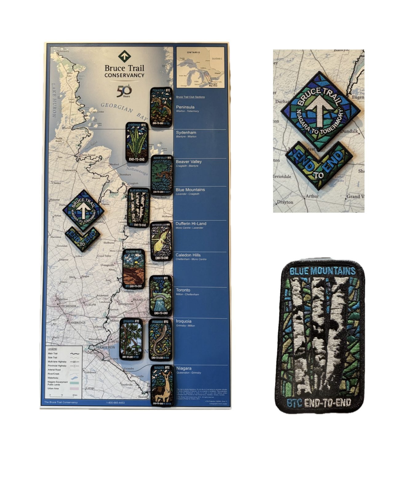
Blue Mountains End to End Fundraiser for the Stained Glass Badge June 6,7,8, 2026
https://hikes.brucetrail.org/event/blue-mountains-end-to-end-fundraiser-for-the-stained-glass-badge-june-678-2026/Sorry, the registration cut-off time for this hike has been reached.Not a member? Click here to join today!This is a Multi-Day Hike
You are signing up for the following dates and times:
2026-06-06 at 07:30
2026-06-07 at
2026-06-08 atHosting Club: Iroquoia, Blue Mountains
Category: Stained Glass Badge End to End Fundraiser Hike
Location (Google Maps): Registered participants will receive a WhatsApp invitation (optional)which can be used for photo share and other pertinent information.This is a three day fundraiser ETE for the stained glass badge. You must be able to hike at least 4km an hour with hills and rough terrain.
June 6 – Day 1 – Meet in the parking lot parking lot area located 380 m north of the main trail crossing Pretty River Road (40 car capacity) 44.430927, -80.275390 Shuttle to Maple Lane in Ravenna. Park only on the north side 44.504973, -80.331780 (4 car capacity) 20km
June 7 – Day 2 – Meet in the parking lot parking lot area located 380 m north of the main trail crossing Pretty River Road (40 car capacity) 44.430927, -80.275390 Shuttle to $paid parking lot off of 15/16 Sideroad – accessible only from Concession 10 South. 44.342784, -80.210628 (car capacity 7) 24km
June 8 Day 3 – Meet in front of the Lavender Cemetery on Mulmar Nottawasaga Townline 550 meters east of Lavender Hill Road – do not block cemetery gate. 44.268777, -80.156810 (Car capacity 10) and shuttle to $paid parking lot on 15/16 Sideroad 44.342784, -80.210628 (Car capacity 7) 22.50km.Parking fees are shared by everyone except the drivers.
Hike Leader(s): Ruth Moffatt Click here to contact Hike Leader(s)
Pace: Brisk – 4 to 5 km/hr
Terrain: Moderate – Some hills and/or some poor footing, Slippery and Steep Sections, Strenuous – Hilly with steep climbs and some poor footing
Distance: 67.50km spread over three daysDescription
Everyone who is registered for this hike series will be invited to join an optional WhatsApp which can be used to share photos and other information.Distances will be spread over 3 days as equally as possible depending on the parking. Please bring enough food and snacks for a 20km + day of hiking and 2l of water minimum.
Everyone must have a first aid kit in their backpack as well as all the other items you require for a long day hike (poles, rain gear etc)
The registration fee includes the badge, guidance and organization. The fee supports the club’s infrastructure and the mission of “Preserving a ribbon of wilderness for everyone, forever.” There are no refunds.This series of hikes is intended for hikers who are used to a multi-day distance of 20+km at a steady pace. We will have a short break around 10am and a lunch break. Afternoon break is dependent on expected finishing time. Please do not over estimate your hiking ability.
Participants can make up one of the three days on their own if you have a scheduling conflict. Please try to do this before we get started.
You must be willing to share in the car shuttle to the start of the hike or driving the drivers back at the end of the day. Please have a minimum 4 useable seats including driver’s. This is a group hike and it is intended that everyone be present on each day.
Please cancel your registration if your plans change so that someone else who may be on the waitlist can take your place. Paid parking on two days to be shared by non-drivers.All registered hikers will be invited to join a WhatsApp group. This can be used for sharing photos and other items of interest.
Refunds: https://brucetrail.org/paid-hike-refund-policy/
RAINBOW HIKE: Birding with Pride
https://hikes.brucetrail.org/event/rainbow-hike-birding-with-pride/Sorry, the registration cut-off time for this hike has been reached.Not a member? Click here to join today!Hosting Club: Iroquoia
Category: Rainbow Hike
Location (Google Maps): Royal Botanical Gardens – Hendrie Valley Sanctuary, Cherry Hill GateHike Leader(s): Shayne Ward Click here to contact Hike Leader(s)
Pace: Leisurely – 3km/hr or less
Terrain: Easy – Mostly flat and usually good footing, Moderate – Some hills and/or some poor footing
Distance: 5KMDescription
Join us as we kick off Pride Month with a colourful morning of birding! 🦅🦉🦆🌈For this edition, it’s encouraged to come dressed in the colours of your favourite bird! 🌈
This gentle early-morning outing will explore the trails around Royal Botanical Gardens, one of our region’s important migration areas. We will start at the trailhead parking lot of the Cherry Hill Gate.
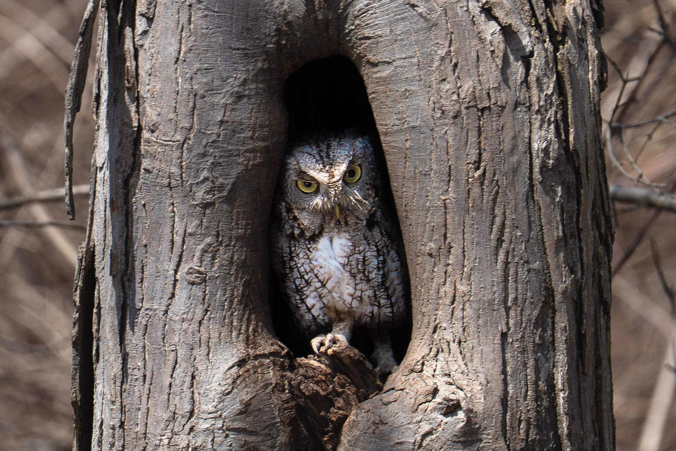
Plan to arrive for 745AM and we’ll have a small crash course on downloading and using two popular birding apps, Merlin Bird ID and eBird recording our sightings! We’ll depart by 8-810AM. Hoping to catch some Blue Herons, Swans, Wood Ducks, and if we’re lucky, a sighting of the RBG resident Screech Owl!
🌈 This is a queer-led, 2SLGBTQIA+ inclusive Rainbow Hike, welcoming LGBTQ+ hikers, allies, birders, photographers, and anyone interested in connecting with nature and community. This is a short, relaxed hike (approx. 5 km) designed to get us moving and birding!
What to Bring
• Water and light snacks
• Weather-appropriate clothing and sturdy footwear
• Binoculars or camera if you have them (optional but fun! And a cell phone counts!)Not a Bruce Trail member yet?! Sign up here!
https://brucetrail.org/become-a-member/Come enjoy a spring morning on the trail, celebrate migratory birds, and connect with your Bruce Trail community!
🐾 Please leave pets at home for this hike! It’s migration season and we’ll be passing through an important bird migration and nesting area, so we want to keep disturbance to our feathered friends to a minimum! 🐦
🚗 🚌 This outing is accessible by car or public transit.
Planning to drive?
Parking is 3$/hour to a maximum of 15$ if you park at Cherry Hill Gate, or free if you park across the street at RBG Centre.Taking the Bus?
HSR #9 or BT1 stops near the trailhead entrance! Map of the bus and it’s schedule can be found here.
https://www.hamilton.ca/sites/default/files/2026-04/hsr-9-ROCK%20GARDENS-may10.pdfFree Bruce Trail Rainbow badges and stickers for all participants!
Questions? Simply click “Contact Hike Leader” on the registration form.
CANCELLED: Petroglyphs Provincial Park
https://hikes.brucetrail.org/event/coach-trip-petroglyphs-provincial-park/Sorry, the registration cut-off time for this hike has been reached.Not a member? Click here to join today!Hosting Club: Toronto
Category: Cancelled
Location (Google Maps): Petroglyphs Provincial ParkHike Leader(s): Robin Crombie and Felix Wan Click here to contact Hike Leader(s)
Pace: Moderate (3-4 km/hr)
Terrain: Hilly, Level 2 (Intermediate – some hills and uneven surfaces, rocks and roots underfoot), Rocky, Variable
Distance (km): 8Description
This trip has been cancelled and will be rescheduled to a future date – June 6th is a holiday for Nishnaabeg and access to the site will be limitedIn recognition of June being National Indigenous History Month in Canada, join us for a visit to Petroglyphs Provincial Park.
The day will be divided into two portions. We’ll begin by touring the exhibits and watching a 20-minute video at the Learning Place Visitor Centre to discover the traditions of the Ojibway (Nishnaabe) people, which will be followed by a 45-minute guided tour of the Kinoomaage Waapkong (aka The Teaching Rocks or the Peterborough Petroglyphs), the largest known concentration of Indigenous rock carvings (petroglyphs) in Canada. Afterwards, we will hike along the Nanabush Trail, stopping near Minnow Lake for a lunch break, then continue our hike along the Marsh and West Day Use Trails.
Although the total hiking distance is short (approximately 8 km), the trails are in the heart of the Canadian Shield and are rugged. There are rocks and roots, and some hilly stretches. Bring hiking boots and poles if you have them. Also bring a lunch and snacks, at least 2L of drinking water, rain/sun protection, and insect repellent.
If time permits, we will have a refreshment stop in the town of Lakefield.
Expect a late return to Toronto (approximately 7:00 p.m., traffic conditions permitting).
Car Hike: Glasgow Village
https://hikes.brucetrail.org/event/car-hike-glasgow-village-uxbridge-7/Sorry, the registration cut-off time for this hike has been reached.Not a member? Click here to join today!Hosting Club: Toronto
Location (Google Maps): Glasgow Trail, Concession Road 2
Park in parking lot at the head of trail
Hike Leader(s): MOHAMMAD AGHAMIRI Click here to contact Hike Leader(s)
Pace: Moderate (3-4 km/hr)
Terrain: Hilly, Level 2 (Intermediate – some hills and uneven surfaces, rocks and roots underfoot), Variable
Distance (km): 14-15 kmDescription
Lets explore Goodwood conservation area and visit Secord forest and pondSeven Rivers Hike Badge Series - Hike 2
https://hikes.brucetrail.org/event/seven-rivers-hike-badge-series-hike-2/Sorry, the registration cut-off time for this hike has been reached.Not a member? Click here to join today!Hosting Club: Dufferin Hi-Land
Category: General Hike
Location (Google Maps): Mad River Blue Mountains Section Map 22
Parking: lot off County Road 124, east of Singhampton and west of Devil’s Glen Country Club in front of the Devil’s Glen Provincial Park gates.Hike Leader(s): Tristan Goguen and Pat Foley Click here to contact Hike Leader(s)
Pace: Medium
Terrain: Moderate
Distance: 10.9KmDescription
Today we will hike from the parking lot to the viewing platform then return to the main trail walking southbound until we meet the Ganaraska Trail. We will hike along the Ganaraska trail until we come out on Concession Road 8 in Glen Huron. Just past station Street we will turn west and follow the Mad River Side Trail until we rejoin the main trail. From there we will hike back to the cars.Please be prepared for the weather, we will hike rain or shine. Ensure you have enough water,lunch and snacks, sunscreen and bug repellent. Hats and sunglasses are recommended as are poles and sturdy shoes.
For those wishing to earn their 7 Rivers – complete all 7 hikes, badges will be available on the last day from the hike leaders at a cost of $10 for members and $15 for non members.
Anyone completing make-up hikes may log their hikes and apply directly to the Dufferin Highlands BT Club for the badge.
9:00 am Walker Creek 5 4 3 2 1 Grounding Hike
https://hikes.brucetrail.org/event/900-am-walker-creek-5-4-3-2-1-grounding-hike/Sorry, the registration cut-off time for this hike has been reached.Not a member? Click here to join today!Hike open to BTC Members only.
Hosting Club: Niagara
Category: Mindfulness
Location (Google Maps):Welland Canal parking area at Lock 1 on Lakeshore Road
Hike Leader(s): Suzanne Gourluck Click here to contact Hike Leader(s)
Pace: Leisurely <3 km/hr
Terrain: Easy: mostly flat, good footing
Distance: 9 kmDescription
*This hike is one of our new MINDFULNESS seriesJoin me on this 5 4 3 2 1 grounding hike and learn a simple strategy for managing anxious racing thoughts. We will hike through Malcomson Eco Park along Sunshine beach, up Walker Creek and back, stopping a couple of times along the way to ground ourselves using the 5 4 3 2 1 technique.
*If the parking lot at the canal is full please park in Malcolmson Eco Park (accessed at the Niagara/Lakeshore intersection) and walk up to the canal.
International Trails Day Hike - Cotswold Way
https://hikes.brucetrail.org/event/international-trails-day-hike-cotswold-way/Sorry, the registration cut-off time for this hike has been reached.Not a member? Click here to join today!Hosting Club: Peninsula
Location (Google Maps): BTC Parking Lot, #2461 Bruce County Rd. 9
Hike Leader(s): Marg and Owen Glendon Click here to contact Hike Leader(s)
Pace: Medium (3.0 – 4.5 km/h): A comfortable pace for most hikers with steady progress.
Terrain: Difficult: Steep ascents/descents, rocky scrambling, and some rugged escarpment paths., Moderate: Rolling hills, mild slopes and rocky paths.
Distance: ~6.5 kmDescription
Celebrate International Trails Day on June 6 with a hike that connects you to trails around the world.Step onto the Bruce Trail and discover the spirit of global adventure through the Friendship Trails program, an international network linking trail communities across countries. Like twin towns, these special partnerships bring people together through shared experiences, culture, and a love of the outdoors.
Bruce Trail Conservancy maintains 10 Friendship Trails at different locations along the Bruce Trail. The Peninsula Bruce Trail Club is proud to host two of these international connections: England’s Cotswold Way and South West Coastal Path. Learn more about BTC Friendship Trails here: https://brucetrail.org/International-friendship-trails/.
Kick off our three-part Friendship Hike series on the Cotswold Way Friendship Trail section with a scenic 6.5 km loop hike along the Main Trail and Beth Gilhespy Side Trail, near Barrow Bay. This moderately paced hike features rugged, rocky terrain, a few challenging climbs, and breathtaking views over Georgian Bay and Little Lake, perfect for sparking your next hike-travel dream. Plan on 2 1/2 – 3 hours which includes lots of time for photos and storytelling.
We are thrilled to have two knowledgeable guests join us for the hike! Jackie Randle, BTC Vice President of Operations and President of the World Trails Network, will share inspiring stories and insights about International Friendship Trails and the World Trails Network. Tom Hall, PBTC Trail Maintenance Director, and Friendship Trail Badge Earner, will also join us to share some of his hiking experiences along the Cotswold Way Trail.
Have you walked the Cotswold Way? Bring your stories and be part of the conversation.
Celebrate trails around the world and the healthy lifestyle that trails inspire!
Ample parking and onsite portapottie available.
Dr. Philip Gosling Memorial Hike & Founders’ Footpath Plaque Unveiling
https://hikes.brucetrail.org/event/dr-philip-gosling-memorial-hike-founders-footpath-plaque-unveiling/Sorry, the registration cut-off time for this hike has been reached.Not a member? Click here to join today!Hosting Club: Caledon Hills
Category: General
Location (Google Maps): Akela and Scouters Heather and Ross Hamlin Nature Reserve at Riverside Woods
713377 1st Line EHS, Mono
Google GPS Coordinates: 43.959916, -80.070494Driving Directions:
From ON-9, head north onto 2nd Line EHS for 3 kilometres. Turn left onto Side Road 5 for 1.5 kilometres. Turn right onto 1st Line EHS for approximately 1 kilometre. Continue straight into the parking lot.From ON-10, head east on Hockley Road/Dufferin County Road 7 for 1 kilometre. Continue straight onto Side Road 5 for 1.5 kilometres. Turn left onto 1st Line EHS for approximately 1 kilometre. Continue straight into the parking lot.
Hike Leader(s): Sandy Green Click here to contact Hike Leader(s)
Pace: Brisk – 4 to 5 km/hour, Leisurely – 3 km/hour or less
Terrain: Easy – mostly flat and usually good footing
Distance: 2 or 3 kilometresDescription
Bruce Trail members and friends are invited to gather in nature to honour the life, vision, and legacy of Dr. Philip Gosling, Founder of the Bruce Trail. A time of reflection and the unveiling of the Founders’ Footpath commemorative plaque will be led by Michael McDonald, CEO of the Bruce Trail Conservancy, followed by a guided walk along the footpath, and a time of fellowship and refreshments.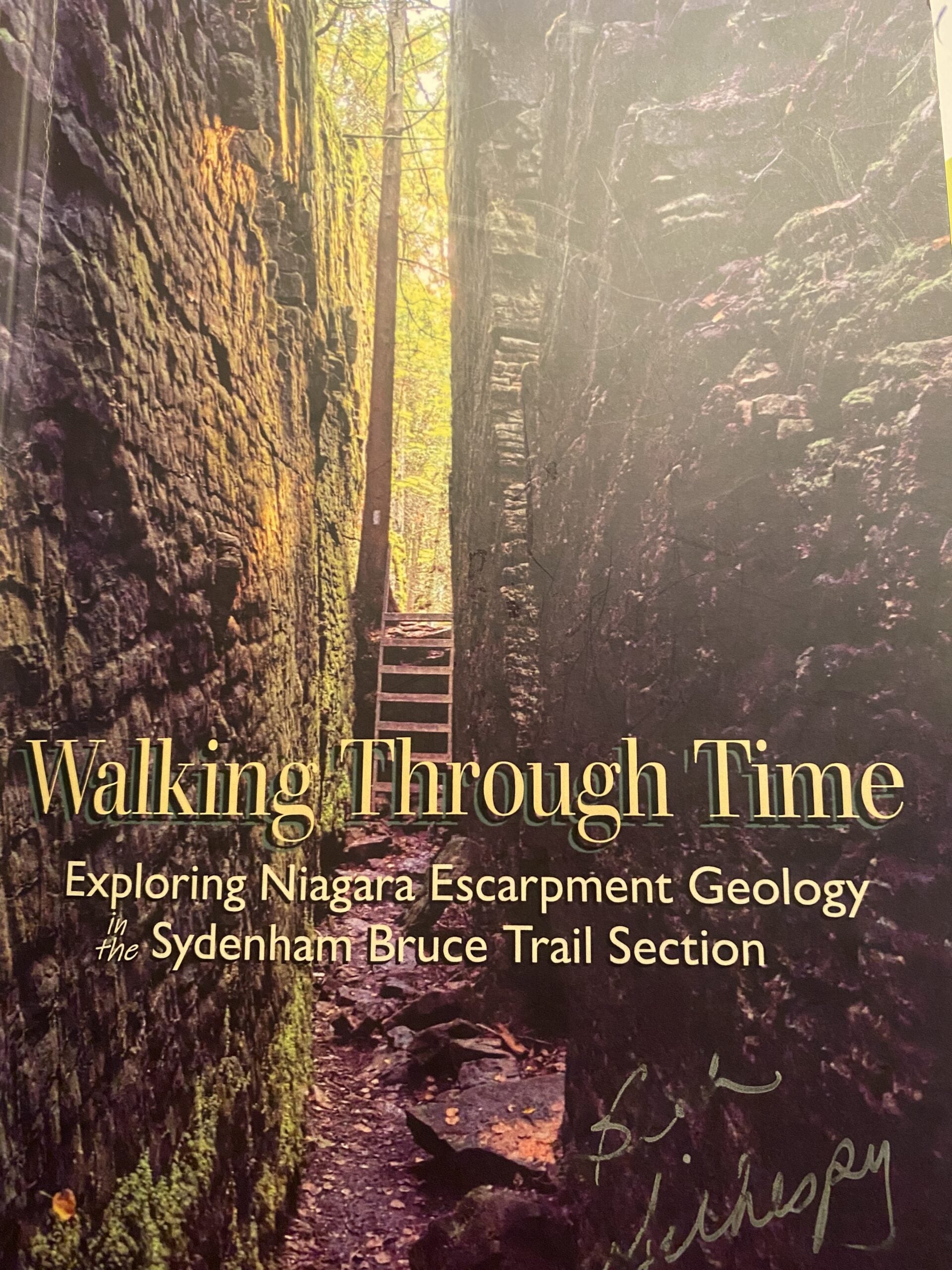
Geology Hike #6B Inglis Falls loop
https://hikes.brucetrail.org/event/geology-hike-6b-inglis-falls-loop-2/Sorry, the registration cut-off time for this hike has been reached.Not a member? Click here to join today!Hosting Club: Sydenham
Category: Geology Hike
Location (Google Maps):Meet in the parking lot behind the Grey-Sauble Conservation Authority head office.
237897 Inglis Falls Road, Owen SoundHike Leader(s): Beth Gilhespy Click here to contact Hike Leader(s)
Pace: Leisurely: 3 km/h or less
Terrain: Moderate: Some hills and/or poor footing, Strenuous: Hilly with steep climbs and some poor footing., There might be muddy sections., There might be sections with water on the trail.
Distance: 5.5 km. approxDescription
This is part B of Geology Hike #6 (Inglis Falls loop) following Beth Gilhespy’s book “Walking Through Time” in the Sydenham Bruce Trail Section and BETH GILHESPY will be leading this hike ! This is a loop, starting from the parking lot at Grey Sauble Conservation Area parking lot behind the main building. We will hike in a southerly direction on the main trail towards Inglis Falls, cross the Inglis Falls Road and continue on main trail to join the Creamery Hill sidetrail and back to our cars.Copies of all of Beth’s books will be available for purchase. Special member’s only price of $37.00 . Cash or etransfer. If paying with cash, please bring exact change. Please bring water and a snack if you wish. Proper hiking footwear and hiking poles are recommended.
Car Hike: Scotsdale Farm,Map 13
https://hikes.brucetrail.org/event/car-hike-scotsdale-farm-map-13/Sorry, the registration cut-off time for this hike has been reached.Not a member? Click here to join today!Hosting Club: Toronto
Category: Car Hike
Location (Google Maps):Scotsdale Farm, Map 13
Hike Leader(s): Al Brown Click here to contact Hike Leader(s)
Pace: Moderate (3-4 km/hr)
Terrain: Level 2 (Intermediate – some hills and uneven surfaces, rocks and roots underfoot), Variable
Distance (km): 13 kmDescription
Come join me for hike through Scotsdale Farm and the Silver Creek Conservation Area.We will complete a loop hike on the main and side trails. Shorter loops are available for those who do not want to complete the full length. After the hike all are invited to join me for refreshments at the Shepherd’s Crook in old Georgetown.
To get to the meeting point from Hwy 401 go north on Trafalgar Road past Georgetown to the juncture with Hwy 7. North on Hwy 7 to Silver Creek. Turn right and back onto Trafalgar Road. Go north about 1.5 km to the entrance of Scotsdale Farm on your right. The parking area is about 0.5 km from Trafalgar Road near the old homestead.
American Chestnut Tree Maintenance
https://hikes.brucetrail.org/event/american-chestnut-tree-maintenance/Sorry, the registration cut-off time for this hike has been reached.Not a member? Click here to join today!Hosting Club: Dufferin Hi-Land
Category: Special Events
Location (Google Maps): Bruce Trail Parking Lot on the 1st line EHike Leader(s): Cathy Hughes
Pace: Leisurely
Terrain: Easy
Distance: 3 kmDescription
In Fall 2024, approximately 90 American Chestnut trees were planted on the property. Be part of the ongoing monitoring and maintenance program. Volunteers will assist DHBTC Biodiversity Committee members and Bruce Trail Conservancy Ecologists with mulching and replacing tree guards. We will also be examining trees to help determine survival rates. Some invasive species removal may also occur.If time permits, a short hike of the area will occur.
Please bring water and gloves if you have them. It is recommended you dress according to the weather and wear sturdy boots or shoes and long pants as ticks are possible in the area. All other equipment will be provided.
Urban Walk - Don Valley to The Distillery District (29 KM)
https://hikes.brucetrail.org/event/urban-walk-don-valley-to-the-distillery-district-29-km/Sorry, the registration cut-off time for this hike has been reached.Not a member? Click here to join today!Hosting Club: Toronto
Category: Urban Walk
Location (Google Maps): East Don/Don RiverHike Leader(s): Brian Rideout Click here to contact Hike Leader(s)
Pace: Moderate (3-4 km/hr)
Terrain: Flat
Distance (km): 27.5 kmDescription
This hike follows the Don River south from Steeles Ave East at Leslie St through Toronto to the Distillery District, through a series of ravines and several parks. We will detour to street level when we cross the 401 (trail closed due to construction) and again south of Pottery Rd where we take the Bayview Ave Extension (trail closed due to construction). Those who register will receive an itinerary.Please bring a lunch and at least two liters of water. Be prepared for cool / wet weather. Pub stop after at The Spaghetti Factory, adds an extra 1.5 KM
Here is an online map of our route: Don Valley to The Distillery https://onthegomap.com/s/7og8khua
Here is the itinerary for the day.
10:00 AM
0
Steeles and Leslie11:45 AM
6
Sheppard and Leslie – east end of subway station at street level12:48 PM
9.6
Lesmill & York Mills Tim Horton’s)1:40 PM
12.6
Edwards Gardens (Lawrence and Leslie) – 15 minute lunch break max2:48 PM
15.6
Underpass of Eglinton, west of Leslie – in the parking lot east end near the bins3:06 PM
16.6
behind the Ontario Science Centre – we will not be leaving the path4:40 PM
22
Pottery Rd – at cross walk5:33 PM
25
Riverdale Park Crossing6:15 PM
27.5
Distillery District – TTC terminus6:45 PM
29
The Old Spaghetti Factory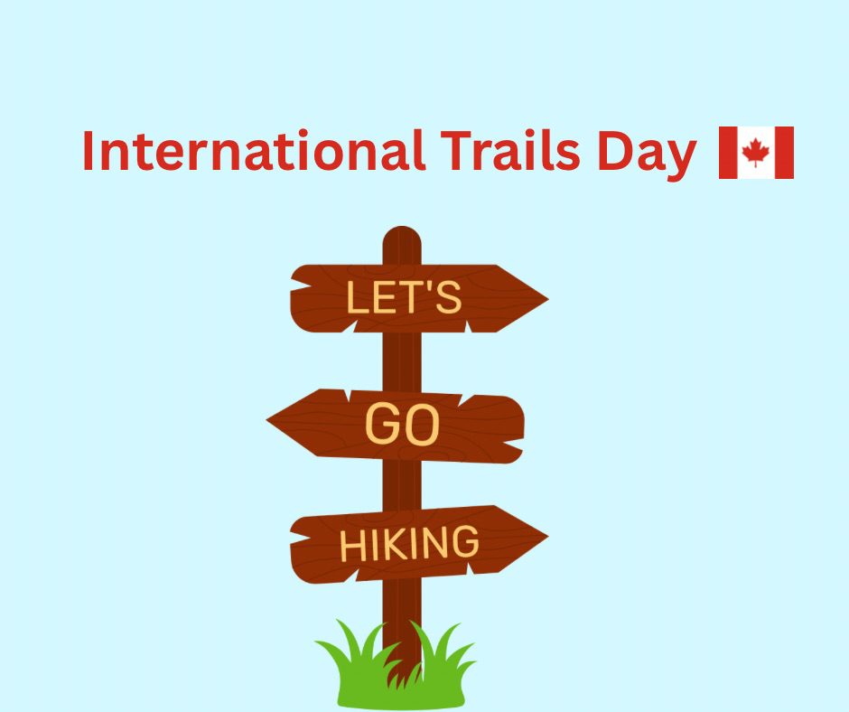
International Trails Day Celebration and Saturday Shorts Hike
https://hikes.brucetrail.org/event/international-trails-day-celebration-and-saturday-shorts-hike/Sorry, the registration cut-off time for this hike has been reached.Not a member? Click here to join today!Hosting Club: Caledon Hills
Category: General
Location (Google Maps): Meet in the Caledon Public Library – Alton Branch
35 Station StreetDriving Directions: From ON-10, turn west on Charleston Sideroad/Peel Regional Road 24 for 4 kilometres. Turn right/north onto 3 LineW/Main Street/Peel Regional Road/136 for 4 kilometres. Turn right onto Station Street. The library is on the right side.
Hike Leader(s): Sandy Green Click here to contact Hike Leader(s)
Pace: Leisurely – 3 km/hour or less
Terrain: Easy – mostly flat and usually good footing
Distance: 5.5 kilometresDescription
Plan to join our local celebration of International Trails Day – promised fun for all. Come to the library early (1:00 pm to 2:00 pm) to learn more about local trails, healthy lifestyles, and volunteering through hands-on activities, conversation, giveaways, and fabulous door prizes. A loop around the biodiverse Alton Grange Property will offer many exciting opportunities for nature sightings. Bring a beverage and snack to keep you energized on the trail. This special hiking event is brought to you by the Caledon Public Library, Caledon Hills BTC, Alton Grange Association, and WILD Outside Youth Leadership Group.