Categories
- 28June 28, 2026
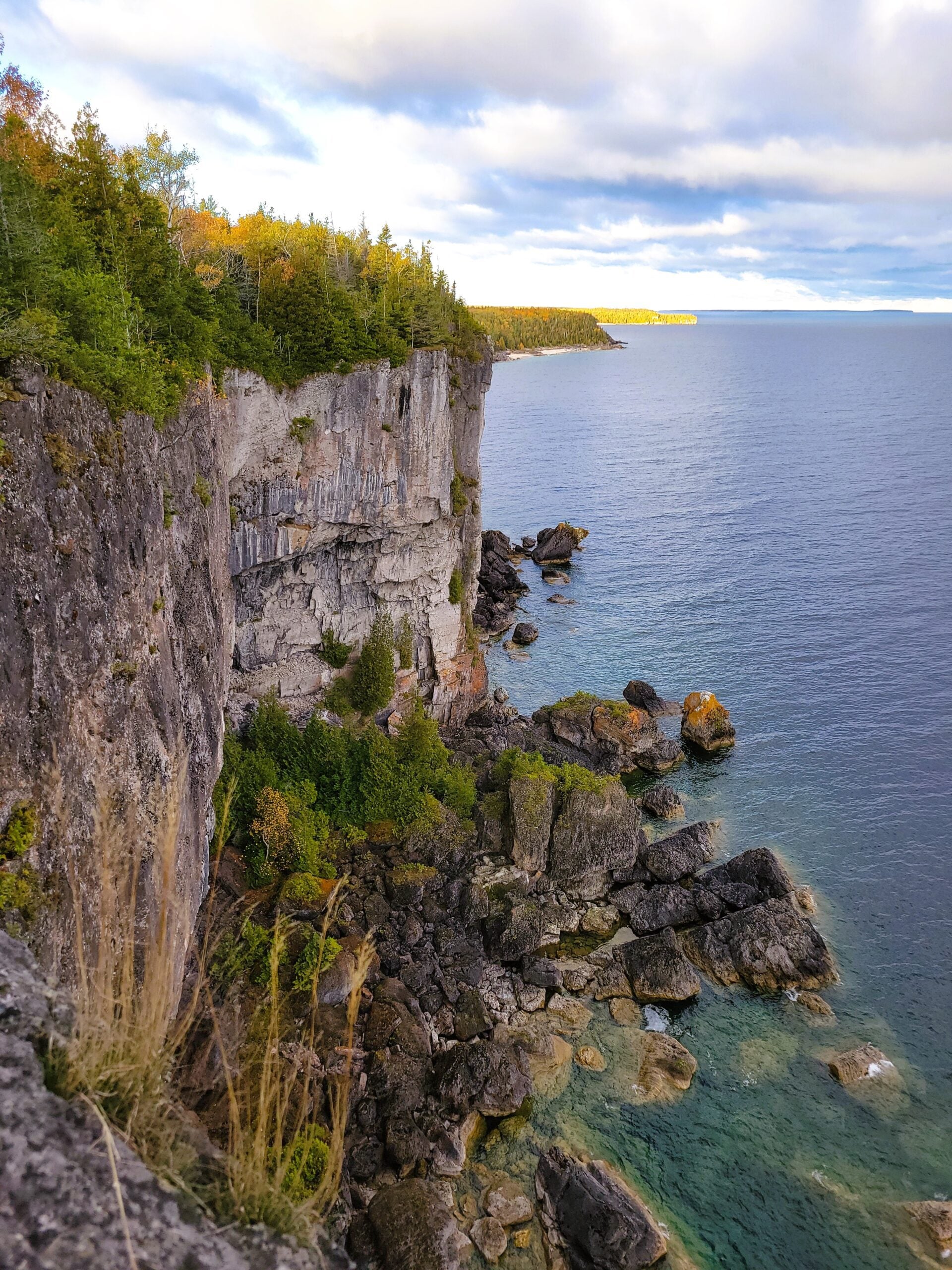
Peninsula BT Makeup Hike (km 139.5 – km 156.4)
https://hikes.brucetrail.org/event/peninsula-bt-makeup-hike-km-139-5-km-156-4-2/Sorry, the registration cut-off time for this hike has been reached.Not a member? Click here to join today!Hosting Club: Peninsula
Category: Peninsula BT Makeup Hike
Location (Google Maps):Hike Leader(s): Kathleen Stahlbaum & Saabir Sohrab Click here to contact Hike Leader(s)
Pace: Medium (3.0 – 4.5 km/h): A comfortable pace for most hikers with steady progress.
Terrain: Difficult: Steep ascents/descents, rocky scrambling, and some rugged escarpment paths.
Distance: ~17.8Description
Halfway Log dump to Little Cove parking lotThis hike is part of the Peninsula BT Makeup Hikes, intended for hikers completing missed sections of the Peninsula Bruce Trail. Each hike requires individual registration.
To hike the entire Peninsula Section, please register for the Full Peninsula End-to-End Series (single registration for all 10 hikes): https://hikes.brucetrail.org/event/peninsula-end2end-in-10-series/2026-05-01/
Hikers may register for all 10 Makeup Hikes if they wish.
Expectations: Expect ~6 hours on the trail, depending on the terrain, weather, and group pace. The hike leader sets the pace, aiming for 3–4 km/h, and may adjust as needed for group ability and trail conditions. Breaks will be taken throughout the day.
For safety, participants must remain between the hike leader and the hike sweep at all times.
Fees:
- Registration fee does not include Bruce Peninsula National Park entry fees and parking fees
- Parking costs will be shared equally among participants.
- Fundraising: This hike is a fundraiser to support the Peninsula Bruce Trail Club’s volunteer-run hike program.
Participant Requirements
- Intermediate/experienced hikers with good fitness
- Proper hiking boots, layered clothing, wet weather gear
- Hiking poles recommended
- Bring: Lunch, snacks, water, bug spray
Transportation & Accommodations
- Car shuttle: Participants rotate as drivers; vehicles must be passenger-ready
- Accommodations: Book early; options include motels, campgrounds, hostels, and B&Bs
Note: Dogs are not permitted.
Car Hike: Uxbridge-Brock Track
https://hikes.brucetrail.org/event/car-hike-uxbridge-brock-track-6/Sorry, the registration cut-off time for this hike has been reached.Not a member? Click here to join today!Hosting Club: Toronto
Category: Car Hike
Location (Google Maps):Meet at the Brock Tract parking lot on the east side of Durham 1/Brock Rd., approximately 5 km south of Coppin’s Corners, Uxbridge or 1 km north of Uxbridge Pickering Town Line. 1401 Brock Rd. (Free parking).
Hike Leader(s): Amir Alemohammad Click here to contact Hike Leader(s)
Pace: Moderate (3-4 km/hr)
Terrain: Flat, Hilly, Level 2 (Intermediate – some hills and uneven surfaces, rocks and roots underfoot), Variable
Distance (km): 10-12 kmDescription
Join us for a wonderful hike in Uxbridge starting from Brock Track parking lot. We will hike the Brock Track and Wilder Forest among the amazing trails of Uxbridge.Boots and icers mandatory, poles recommended, bring 2 litres of water and dress according to weather conditions. Be prepared for icy/snowy conditions.
Please arrive at 7:45 for a 8:00 start.
Beware, Iphone Maps may take you to the wrong location. Check the location with Google Maps the previous night.
This is a joint hike with Oak Ridges Trail Association (ORTA).
Sunny Sundays - Talisman to Epping
https://hikes.brucetrail.org/event/sunny-sundays-talisman-to-epping/Sorry, the registration cut-off time for this hike has been reached.Not a member? Click here to join today!Hosting Club: Beaver Valley
Location (Google Maps): Meet in the Epping/John Muir Lookout on Grey Road 7, km 94.3, Map 27, Edition 31, check Google Maps in hike listing for coordinates. We will shuttle to Sideroad 7A, Talisman.
Hike Leader(s): Glenda Collings Click here to contact the hike leader.
Pace: Medium
Terrain: Moderate, Some rocky footing, Some steep sections
Length of Hike: 11.9 kmDescription
We’ll experience hiking by a beaver pond and along the edges of fields as we make our way along the escarpment, through forest, to end up at the BTC recently acquired section of the old Talisman Ski Club property, with more great views. Please ensure you arrive ready for the car shuttle at 8:15 a.m for an 8:30 a.m. start. Bring water and snacks. We’ll have a couple of short breaks and a mid hike break for snacks. Dress appropriately for the weather and trail conditions. Bring sunscreen and insect repellent or protective covering like a bug hat and long sleeves. You can use the “Click here to contact the hike leader” option in the hike listing if you have any questions.
Terra Cotta to Boston Mills Rd (E2E)
https://hikes.brucetrail.org/event/terra-cotta-to-boston-mills-rd-e2e-2/Sorry, the registration cut-off time for this hike has been reached.Not a member? Click here to join today!Hosting Club: Iroquoia
Category: General Hike
Location (Google Maps): Meet at 9:15 am at the end of Boston Mills Rd.Hike Leader(s): Karen Bergmann Click here to contact Hike Leader(s)
Pace: Medium – 3 to 4 km/hr
Terrain: Moderate – Some hills and/or some poor footing
Distance: 9 kmsDescription
We will meet at the end of Boston Mills Rd (off Mississauga Rd) at 9:15 am and carpool to 10th Line and hike back on the main trail through Terra Cotta Conservation Area, across Winston Churchill Blvd and Heritage Rd and back to the cars. Bring a snack as needed. As well as bug spray/bug net. There are some technical (rocky) parts to this hike. as well as a couple of hilly bits.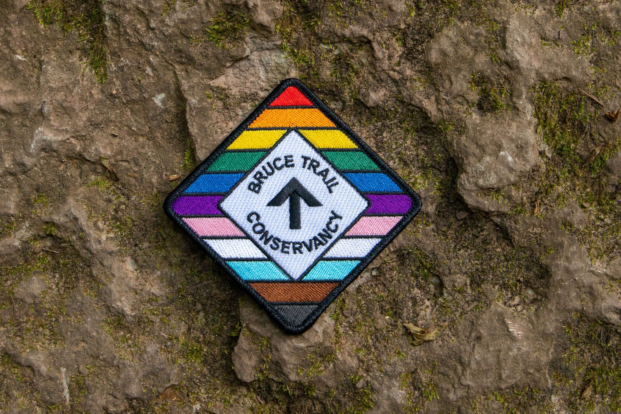
Rainbow Hike: Cave Springs GeoHike
https://hikes.brucetrail.org/event/rainbow-hike-cave-springs-geohike/Sorry, the registration cut-off time for this hike has been reached.Not a member? Click here to join today!Hosting Club: Niagara
Category: Rainbow 🌈
Location (Google Maps): Cave Springs Conservation AreaHike Leader(s): Angela Lytle Click here to contact Hike Leader(s)
Pace: Leisurely <3 km/hr
Terrain: Moderate: some hills and some poor footing
Distance: 2 kmDescription
Join the Niagara Bruce Trail Club, Bridges Niagara Immigrant and Refugee Services and PFLAG Niagara for a Rainbow Hike with Kristin Hanson, GeologistWhat is a Rainbow Hike?
These hikes aim to bring 2S-LGBTQIA+ folks and newcomers together with other newcomers and community members, friends and allies to enjoy nature and connect to the land and enjoy nature in all seasons. It is an intentionally affirming space for people of diverse backgrounds and identities with a focus on 2S-LGBTQIA+ inclusion. Everyone is welcome.
For Pride month, BTC Pride badges and stickers are free for all hikers! Come celebrate Pride with likeminded folks enjoying nature together!Hike Details:
From the Cave Springs Conservation Area parking lot, we will hike along the Ice Cave Trail, the Margaret Reed Side Trail and the main Bruce Trail, stopping to explore and discuss the geology of the Niagara Escarpment, the Beamsville Bench wine region and the physiographic and geologic conditions that make it special.
After a short in-and-out hike on the Ice Cave Trail, we will slowly begin an incline up the Margaret Reed side trail as we scale the Niagara Escarpment.
We will consider the 450+million years of history we are hiking through as we make our way slowly to the top. We will stop along the way to discuss and rest.
Once at the top, the terrain on the Bruce Trail is generally flat but footing may be uneven. It may be wet and slippery if it rains. Hiking poles will make the ascent easier and give more stability on uneven footing. Bug spray is needed at Cave Spring in the summer months. We will hike to the site of the very first blaze on the Bruce Trail and admire the views of Lake Ontario and the vineyards of Cave Spring and Malivoire wineries.
Parking: There is a small parking lot at the entrance to Cave Springs Conservation area on Cave Spring Road, just past the Cave Springs winery.
Please arrive by 9:50 to check in with the hike leaders so we can depart at 10.
GO Train Hike: Nokiidaa Trail
https://hikes.brucetrail.org/event/go-train-hike-nokiidaa-trail/Sorry, the registration cut-off time for this hike has been reached.Not a member? Click here to join today!Hosting Club: Toronto
Category: GO Train Hike
Location (Google Maps):East Gwillimbury GO Station (outside station building)
Hike Leader(s): Tom Swales, Talise Liang Click here to contact Hike Leader(s)
Pace: Moderate (3-4 km/hr)
Terrain: Flat, Level 1 (Easy – mostly on flat, well maintained trails with hard-packed surface)
Distance (km): 9 kmDescription
We will hike south from East Gwillimbury GO Station to Fairy Lake and historic Main Street in Newmarket. We will pass the remains of a swing railway bridge, the remains of an abandoned canal, and a diverse landscape. The walking is easy south on this Level 1 Hike to Fairy Lake where we loop around the lake with a scenic boardwalk trail on the east side and paved path leading into the historic downtown of Newmarket. We’ll stop in the historic downtown for refreshments at the Old Flame Brewery or alternative establishments and walk up Main Street to get the 2:48 pm train back towards Toronto’s Union Station or Downsview Park Station.Drivers may meet at East Gwillimbury GO Station and take the train, GO Bus, or local transit to return to the meeting point.
Take advantage of the GO Transit $10 Day Weekend Pass available only on smartphones. Those wishing to travel together will meet at Union Station in the Great Hall by the information desk (with the clock over it) by 8:40 to take the GO Train towards Barrie departing at 8:52 AM. There is also a stop in Toronto at Downsview Park Station (9:11 AM).
ROUTE MAP: https://onthegomap.com/s/507cjskh

GeoHike - Ball's Falls Conservation Area
https://hikes.brucetrail.org/event/geohike-balls-falls-conservation-area-3/Sorry, the registration cut-off time for this hike has been reached.Not a member? Click here to join today!Hosting Club: Niagara
Category: Geology
Location (Google Maps):3292 Sixth Avenue, Lincoln, ON
Hike Leader(s): Kristin Hanson Click here to contact Hike Leader(s)
Pace: Leisurely <3 km/hr
Terrain: Easy: mostly flat, good footing
Distance: 2.0Description
Look at 438 million years of geologic history and discover why early settlers chose Balls Falls to establish their industrial base. Learn about the formation of the Niagara Escarpment, how glaciation contributed to formation of the valleys and waterfalls, and how the landscape continues to change. We will depart from the Ball’s Falls visitor center – meet at the GeoPoint sign just east of the main doors. We will then follow the short Switchback Trail down into the valley and take the Cataract Trail to the Upper Falls. We will hike along Twenty Mile Creek as it makes its way over the Niagara Escarpment into the Village and get a great view of the Lower Falls. We will use a slow pace and stop and discuss geology along the way. It will only take us 1 hour to cover the distance. When we arrive at the Lower Falls we will stop to enjoy it, and then return to the parking lot. There are washrooms near the village. We will return to the parking lot and visitor center, where there are washrooms and water fountains.Note there is an entrance/parking fee of $15per car but a NPCA parking pass covers this fee; passes may be available to checkout from local libraries
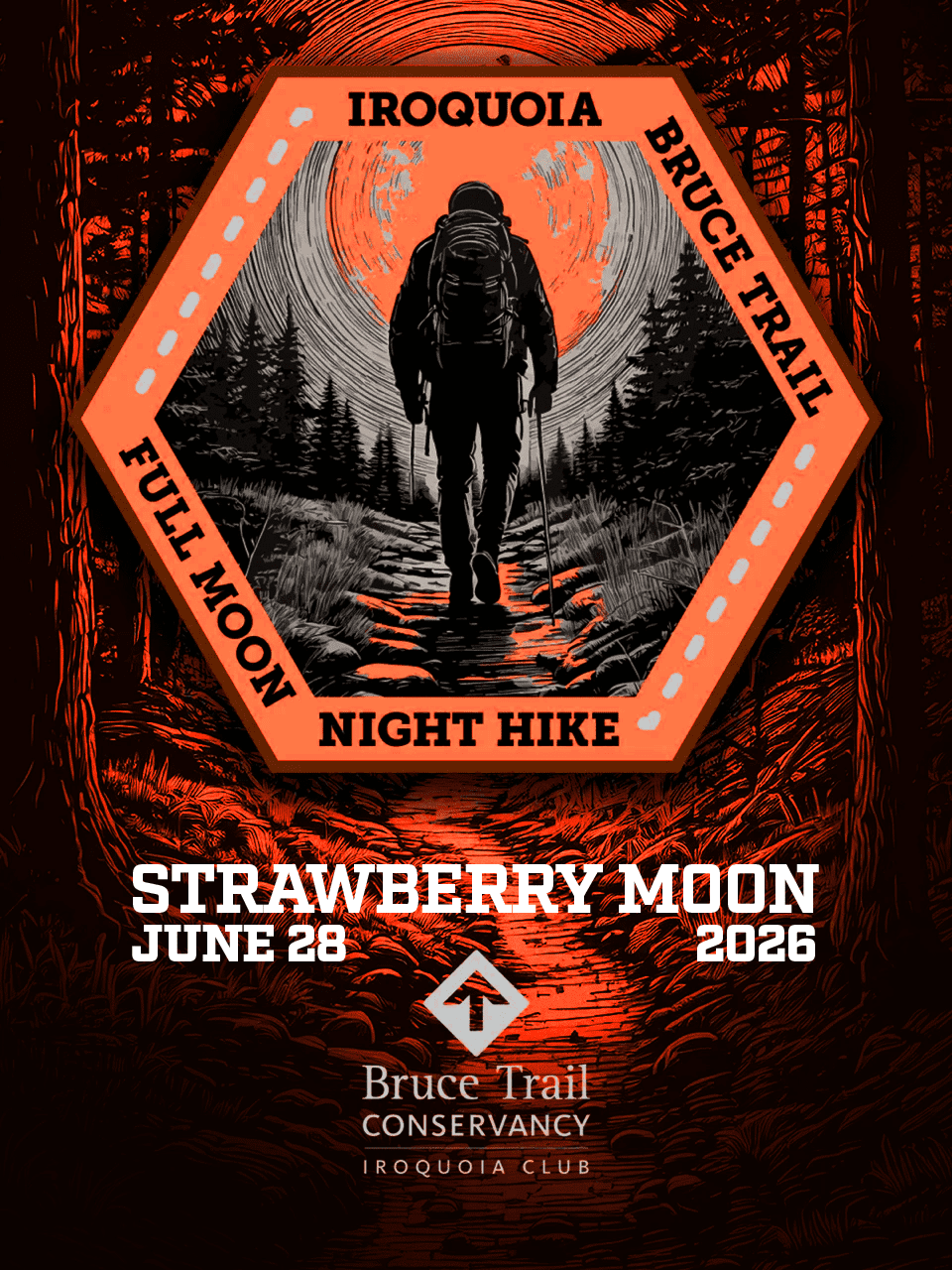
Full Moon Night Hike No.7 (Strawberry Moon)
https://hikes.brucetrail.org/event/full-moon-night-hike-no-7-strawberry-moon/Sorry, the registration cut-off time for this hike has been reached.Not a member? Click here to join today!Hosting Club: Iroquoia
Category: Moonlight Hikes
Location (Google Maps): We will meet at Dundas Driving Park, at 71 Cross St, Dundas. Proceed through the gate and take the road on the right to available parking on the east side of the park. I will have my tailgate up on my white Nissan Qashqai. Please plan to arrive by 9:00 pm so we can get everyone registered and head out at 9:30 pm.Hike Leader(s): Joe Borges Click here to contact Hike Leader(s)
Pace: Medium – 3 to 4 km/hr
Terrain: Dependent on Conditions, Slippery and Steep Sections, Strenuous – Hilly with steep climbs and some poor footing
Distance: 7.5 kmDescription
The Full Strawberry Moon hike is the seventh full moon of 2026. We’ll meet at the parking area inside Dundas Driving Park (71 Cross St Dundas) on the east side of the park. Please plan to arrive by 8:45 pm to get everyone registered and on our way by 9:10 pm.We will hike out of the park along Alma St and pick up the main trail/Tews Fall Side Trail, climbing the escarpment, hiking along the top to Dundas Peak – there will many views overlooking Dundas and afford us some good views of the Full Strawberry Moon. A short pause for pics at the Peak and back down along the Glen Ferguson Side Trail/Tews Fall Side Trail and back to the park and our cars.
Be sure to wear layered clothing, bring water, and poles if you use them. Also headlamp or flashlight. You can leave them off and use them when needed.
If this is your third hike in the series you qualify for the Iroquoia Full Moon badge – new for 2026! Cost is $10 for BTC Members and $15 for non-members. Badges can be picked up at this hike if you pre-order and pay through Iroquoia Bruce Trail Club Badges – Iroquoia Bruce Trail Club
Members / Click to Purchase Your Badges
https://www.zeffy.com/en-CA/ticketing/1de4dba1-aca4-44e2-b0b0-d94f1c826c42Non-Members / Click to Purchase Your Badges
https://www.zeffy.com/en-CA/ticketing/93131d23-cc73-44fe-913d-e4938ee174c6