Categories
- 28June 28, 2025
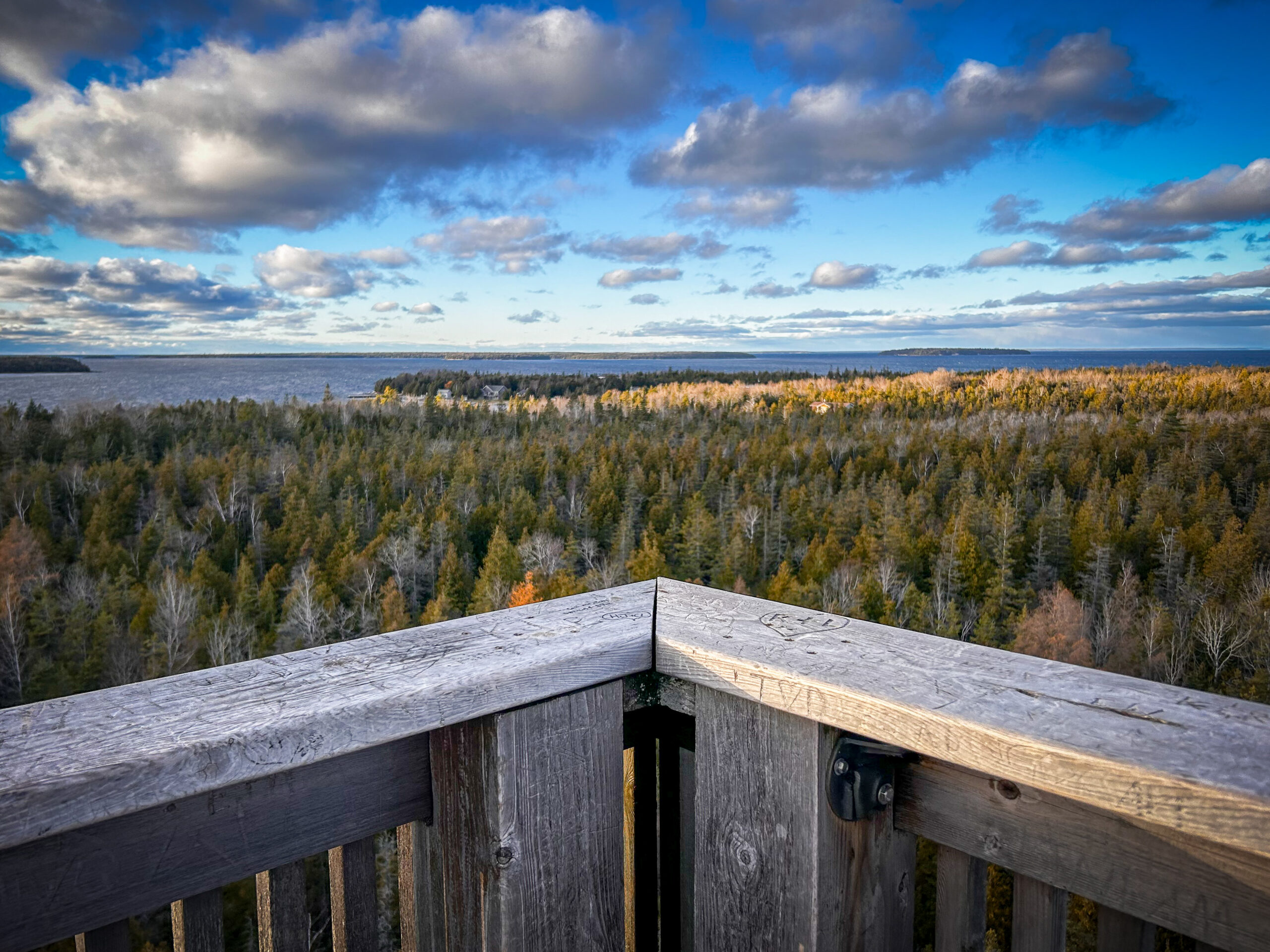
Peninsula Sunrise Series: Burnt Point Loop & Lookout Tower
https://hikes.brucetrail.org/event/peninsula-sunrise-series-burnt-point-loop-lookout-tower/Sorry, the registration cut-off time for this hike has been reached.Not a member? Click here to join today!Hosting Club: Peninsula
Category: Sunrise Hike
Location (Google Maps): Bruce Peninsula National Park Visitor’s CenterHike Leader(s): Kathleen Stahlbaum Click here to contact Hike Leader(s)
Pace: Leisurely (2.0 – 3.0 km/h): A relaxed pace with frequent breaks and a focus on enjoyment.
Terrain: Easy: Flat forested sections or lowland trails., Moderate: Rolling hills, mild slopes and rocky paths.
Distance: ~6 kmDescription
Experience the magic of dawn on the Bruce Trail with the Sunrise Hike Series offered by the Peninsula Bruce Trail Club. These early morning hikes provide a perfect opportunity to awaken your senses, boost your energy, and immerse yourself in the tranquility of nature as the sun paints the sky with breathtaking hues. As we make our way through scenic forest trails, we’ll pause to witness the first light shimmering on the turquoise waters of Georgian Bay – a sight that will surely leave you in awe!Beyond the beauty, morning light helps regulate your circadian rhythm, elevating your mood, boosting energy levels and improving sleep quality. Whether you’re looking to start your day with a sense of calm, capture stunning sunrise photos, or simply reconnect with nature, these hikes offer a unique and inspiring way to greet the day.
On Saturday June 28th, join us in hiking the Burnt Point Loop where we’ll experience the sun rising over the Bay from the edge of the shoreline as well as the iconic Bruce Peninsula National Park Visitor’s Center Lookout Tower. We’ll have the joy of taking in the stunning colours of the sky as the first light sparkles on the stunning turquoise waters. This peaceful sunrise hike is the perfect way to connect with nature, capture some incredible photos, and start the day with fresh air and inspiration. Whether you’re a morning person or just love a good adventure, come experience the magic of dawn from one of the best vantage points on the Bruce Peninsula!
Don’t forget to bring a headlamp or flashlight (preferably with a red light setting) as we begin our adventure in the pre-dawn quiet. Join us and discover how a sunrise hike can nourish your mind, body, and spirit—setting the tone for a brighter, more balanced day.
This hike is approximately 5-6 kms in length. Expect to be on the trail for 2-3 hours (+ additional time for travel from our rendezvous point). Pace will be leisurely with ample time to enjoy the sunrise, take some photographs, and nourish yourself!
How to prepare
- Get a good night’s sleep
- Bring lots of water and a snack (breakfast and/or coffee are recommended if that’s your thing!)
- Bring a headlamp or flashlight (preferably with a red light setting)
- Wear waterproof hiking boots (There will be mud!)
- Hiking poles are recommended but not necessary
- Bring insect repellant or wear protective clothing
- Bring sunscreen
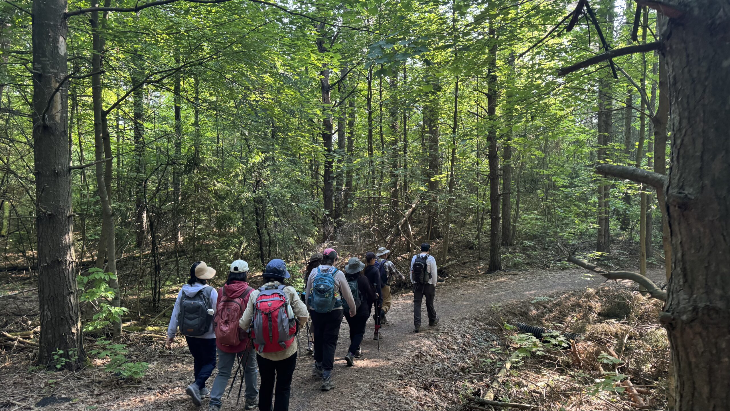
Car Hike: Exploring Uxbridge Trails (Wilder Forest, Walker Woods, and Glen Major Forest)
https://hikes.brucetrail.org/event/car-hike-exploring-uxbridge-trails-wilder-forest-walker-woods-and-glen-major-forest-11/Sorry, the registration cut-off time for this hike has been reached.Not a member? Click here to join today!Hosting Club: Toronto
Category: Car Hike
Location (Google Maps):2499 Brock Rd, Uxbridge, ON L9P 1R4. We will meet at the East Duffins Headwaters parking lot at the WILDER FOREST trail head. As soon as you got off the Brock Road, passing the horse back riding facility, there is a free designated parking lot 70 meters down the lane to your right. It includes a sign board for East Duffins Headwaters with a map of the trails. Please do not park on the lane or in the horse back riding property.
Hike Leader(s): Amir Alemohammad Click here to contact Hike Leader(s)
Pace: Moderate (3-4 km/hr)
Terrain: Flat, Hilly, Level 2 (Intermediate – some hills and uneven surfaces, rocks and roots underfoot), Variable
Distance: Approx.14-15 KmDescription
Join us for a delightful hike in Uxbridge, as we explore Wilder Forest, Walker Woods, and Glen Major Forest on a scenic loop starting from Brock Road. We’ll pass Concession Road 6, heading west and back, while also venturing onto several side trails for even more stunning views.What to Expect:
•Beautiful scenic views and lookouts facing south
•A mix of hilly and flat terrain
•Frequent 2-minute breaks for hydration and photos, with a 10-20 minute lunch/snack stop
•Stay on designated trails at all time
What to Bring and Wear:
•Hiking Boots and poles (recommended) and be prepared for the bugs
•At least 2 liters of water
•Your favorite snacks and lunch (pack your own refreshments for an outdoor meal)
•Dress according to variable weather conditions!
Important Details:
•Stay on the designated trails
•Be prepared for the elements and enjoy the adventure!
Looking forward to seeing you on the trail!
Don’t forget your camera and a smile as we explore the beauty of the Uxbridge trails!
This is a joint hike with the Oak Ridges Trail Association (ORTA).
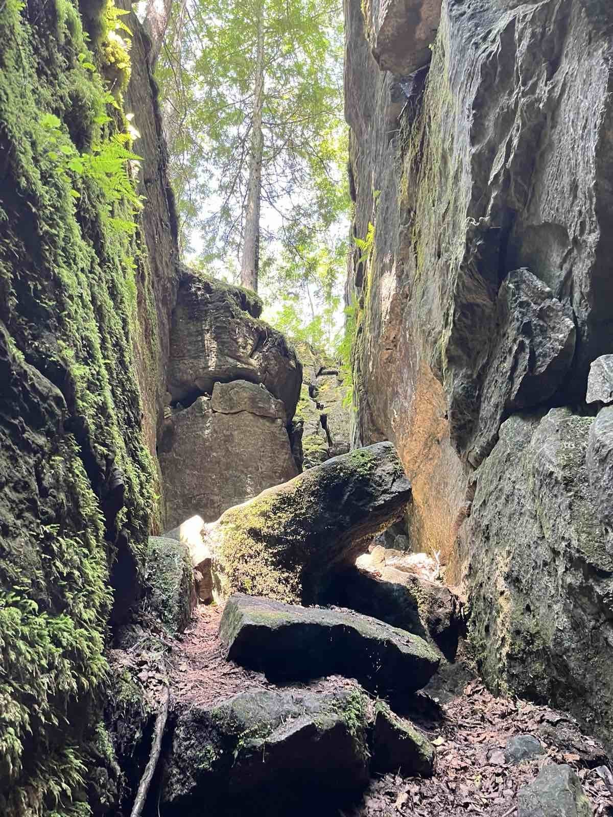
Nottawasaga Lookout Provincial Nature Reserve, Pretty River Valley Provincial Park, Highest Point on the Bruce Trail and Standing Rock and Caves
https://hikes.brucetrail.org/event/nottawasaga-lookout-provincial-nature-reserve-highest-point-on-the-bruce-trail-and-standing-rock-and-caves/Sorry, the registration cut-off time for this hike has been reached.Not a member? Click here to join today!Hosting Club: Toronto, Blue Mountains
Category: Car Hike
Location (Google Maps): GPS N:404107, W: 80.263577 Meet at km 42.4, Map 23, Edition 31. Park on the North end of Osprey-Clearview Townline at Eagle Crescent.Hike Leader(s): Ross Estrella (4163056771) Click here to contact Hike Leader(s)
Pace: Brisk (4-5 km/hr), Moderate (3-4 km/hr)
Terrain: Hilly, Rocky, Variable
Distance: 13.4kmDescription
The beauty of hiking give us the oppurtunity to come close and connect with nature and other living souls. From the jumpstart will hike the Main and Side Trails reaching the highest point of the Bruce Trail. The cliffs, crevices and ravine inhabitants along the forested slope area of Pretty River Valley Provincial Park and Nottawasaga Lookout Provincial Nature Reserve offers scenic the cross section of the Escarpment topograhy. Navigating the Standing Rock and Caves will make your mind ponder the power of erosion during the melting of ice that once covered Southern Ontario over eons ago. So join us and experience nature’s work of art. Please bring enough H2O for hydration, break and lunch fuel to sustained our body and spirit. Sturdy and comfortable hiking shoe and poles are highly recommended. Please equip yourself with sunscreen, hat protection and bugspray as we may be welcome by our nasty mosquitoe friends. Please dress appropriately as to weather forecast and have your personal medications and health card at all times.Please arrive fifteen minutes early to allow time for car shuttling.
Note: Please be on time as we will not wait for latecomers.
My cell number during hike – 416-305-6771
Urban hike German mills
https://hikes.brucetrail.org/event/east-point-park-bird-sanctuary-scarborough-on/Sorry, the registration cut-off time for this hike has been reached.Not a member? Click here to join today!Hosting Club: Toronto
Category: Car Hike
Location (Google Maps): Park along Leslie Street Thornhill.Hike Leader(s): Mohammad Aghamiri Click here to contact Hike Leader(s)
Pace: Moderate (3-4 km/hr)
Terrain: Hilly, Level 2 (Intermediate – some hills and uneven surfaces, rocks and roots underfoot), Variable
Distance: 10-12Description
We will hike along German mills Creek ,then we visit Bestview parkPlease bring hiking poles, proper closing and shoes and lots of water and smile.
For the day of hike phone number 289 588 6482

Beaver Valley Stained Glass E2E in 6 (3 weekends)
https://hikes.brucetrail.org/event/beaver-valley-stained-glass-e2e-in-6-3-weekends/Sorry, the registration cut-off time for this hike has been reached.Not a member? Click here to join today!This is a Multi-Day Hike
You are signing up for the following dates and times:
2025-06-28 at 08:30
2025-06-29 at 08:30
2025-07-12 at 08:30
2025-07-13 at 08:30
2025-07-26 at 08:30
2025-07-27 at 08:30Hosting Club: Iroquoia, Beaver Valley
Category: Stained Glass Badge End to End Fundraiser Hike
Location (Google Maps): Various locations, generally going from north to south (west to east)Hike Leader(s): Freddy Wang Click here to contact Hike Leader(s)
Pace: Brisk – 4 to 5 km/hr
Terrain: Dependent on Conditions, Strenuous – Hilly with steep climbs and some poor footing
Distance: Varies from 15-25 kmDescription
This is a special series of 6 hikes to complete the Beaver Valley section of the Bruce Trail over three weekends (June 27-29, July 12-13, and July 26-27). There is an accomplishment badge included in the registration fee – which was designed by Joe Borges. It depicts the tenacious cedar and is featured along the Beaver Valley section of trail in many spots.The fee goes towards supporting the Beaver Valley Bruce Trail Club, which in turn supports the mission of the Bruce Trail Conservancy, which is: “Preserving a ribbon of wilderness, for everyone, forever.”
For this E2E in 6, we will be following the main trail southbound starting near Blantyre and finishing in Swiss Meadows. Please note that you are signing up for the entire series of six hikes as a Group Hike. This series is geared to experienced hikers with the expectation of a 4.0 to 5.0 km/hr pace maintained over the hike distances below.
This hike is intended to be at a Brisk pace and through a very hilly section. Please be honest about your degree of physical fitness prior to registration. It is a group hike so it is important you are able to keep pace with the person in front of you.
Hikers will be expected to wear proper hiking footwear and layered clothing. Sufficient snacks, water, electrolytes, hiking poles, and bug-resistent gear are recommended.
This series will require car shuttling, so you must be willing to drive and be a passenger.
A maximum of 2 of the 6 hikes can be self-completed as a result of scheduling challenges. You must still complete the distance you have missed. If you miss more than one but still complete the distances on your own, you may apply for the Beaver Valley Club’s regular End to End badge.
Please note there are no refunds!
8:30am Niagara Shores Park Beachcoming Hike
https://hikes.brucetrail.org/event/900am-niagara-shores-park-beachcoming-hike-5/Sorry, the registration cut-off time for this hike has been reached.Not a member? Click here to join today!Hosting Club: Niagara
Category: Loop
Location (Google Maps):Corner of Niven Road and Lakeshore Road in Niagara-on-the-Lake. Park along Old Lakeshore Road.
Hike Leader(s): Suzanne Gourluck Click here to contact Hike Leader(s)
Pace: Leisurely
Terrain: Moderate
Distance: 5-6kmDescription
Explore a lakeshore park, shoreline and cliff top trail in Niagara-on-the-Lake. This beachcombing hike involves uneven ground, clambouring over fallen trees, a pebbly beach, sandy, wet and exposed areas. Hat and poles are highly recommended. Please note: This is not a maintained trail so caution is needed.
Bus Hike: Mystery Hike
https://hikes.brucetrail.org/event/bus-hike-mystery-hike/Sorry, the registration cut-off time for this hike has been reached.Not a member? Click here to join today!Trip Information
Departure Time: 08:30
Return to City Time: 18:00
Departure Point: York Mills Bus PickupOptional Items
Hosting Club: Toronto
Category: Bus Hike
Location (Google Maps): The location will be revealed the date of the hike. The destination will be within an approximately 90 minute drive from York Mills Station.Hike Leader(s): Tom Swales, Felix Wan Click here to contact Hike Leader(s)
Pace: Moderate (3-4 km/hr)
Terrain: Level 2 (Intermediate – some hills and uneven surfaces, rocks and roots underfoot)
Distance: 12-14 kmDescription
Join us on fun day for a moderate level 12 km hike on a trail stewarded by one of our fellow member trail associations of Hike Ontario. The location will be within a 90 minute drive from York Mills (subject to traffic conditions). Like the Bruce Trail, the trail follows one of the geological features of Ontario. After the hike there will be the options to enjoy a lovely white sand beach with scenic views, a local festival, or a pub/restaurant in a picturesque waterfront community. This will be a new hike and not a repeat of any hike on the schedule. That’s all the clues you’ll get. An enjoyable day is promised.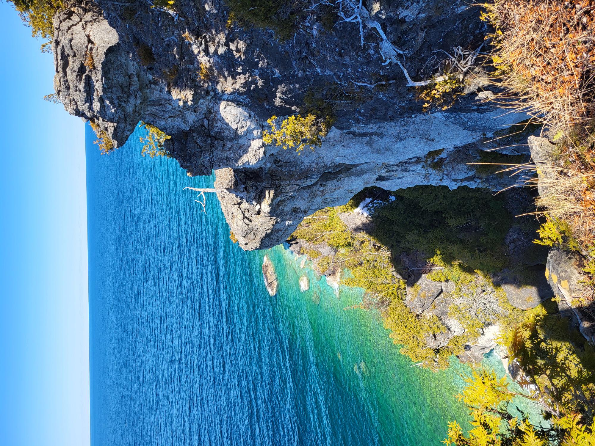
Lion’s Head Look One Day Hike – around 16 km Loop – for adventures and enthusiasts (who loves to drive and hike)
https://hikes.brucetrail.org/event/lions-head-look-one-day-hike-around-16-km-loop-for-adventures-and-enthusiasts-who-loves-to-drive-and-hike/Sorry, the registration cut-off time for this hike has been reached.Not a member? Click here to join today!Hosting Club: Iroquoia, Toronto, Peninsula
Category: Good Companions
Location (Google Maps): Lion’s Head Provincial Nature Reserve -Lion’s Head Parking Rd at the end of Cemetery Rd.Hike Leader(s): Corina Seceleanu Click here to contact Hike Leader(s)
Pace: Medium – 3 to 4 km/hr
Terrain: Strenuous – Hilly with steep climbs and some poor footing
Distance: 16.5 KmDescription
Let’s embark on an unforgettable adventure as we explore the breathtaking Lion’s Head area on Saturday, June 28th,2025. This hike, both exhilarating and rewarding, will take us along a 16.5 km loop that showcases the wonders of the Bruce Peninsula section. Our journey begins at the Cemetery Rd parking lot, where we’ll set off hiking counterclockwise on the main trail.Along the way, we’ll visit incredible landmarks including Gun Point, McKay Harbour, Lion’s Head Point, and the spectacular Lookout. Experience the thrill of crossing the 45th parallel twice, a reminder that you’re in a truly remarkable location. As the trail winds its way through awe-inspiring vistas and tranquil scenery, we’ll eventually connect to the Ilse Hanel Side Trail, leading us back to our starting point.
Whether you’re a seasoned hiker or simply looking for a challenge, this loop offers the perfect blend of beauty and endurance, promising countless moments of discovery and joy. If you crave adventure and long hikes with unforgettable rewards, this experience is not to be missed!
Expectations: This is a difficult hike but we’ll hike at various paces to allow ourselves to enjoy and immerse in an endless beauty of this exploration. Expect to be on-trail 6.5- 7 hours. Breaks will be taken for lunch, snacks, photography and to appreciate the scenery.
Meeting Time: Please arrive no later than 15 minutes prior to the scheduled time.
Participant Requirements:
- Intermediate/experienced hikers, comfortable with longer distances and elevation gains.
- Must be physically fit for group hiking and mentally prepared for an endurance hike
- Proper hiking boots, layered clothing, and wet weather gear. Hiking poles recommended
- Essentials: Lunch, snacks, water (2L min) , bug spray, sunscreen and your enthusiasm
- Breaks for photography and appreciation of local flora and fauna.
Please note: be prepared for a long drive (if you live around the GTA) round trip (around 6.5- 7h) as well for a long hike around 7 h. This is full day adventure.
Any question or inquiry please contact, the Hike Leader!
** For anyone wishing to carpool from GTAA ( meeting point at : Dixie Go Station at 2445 Dixie Rd. Missisauga, ON L4Y 2A1 coordinates 43.608362, -79.579350; cross the Walmart) please meet me at 5:50 am , Saturday June 28th.
It’s customary that if you’re a passenger in a carpool, that a donation towards expense of getting there and return would be appreciated.
Please contact me if anyone whishes to participate !
Thank you!
Till then happy trails, everyone!
Urban Walk: Castle Frank Brook
https://hikes.brucetrail.org/event/urban-walk-castle-frank-brook/Sorry, the registration cut-off time for this hike has been reached.Not a member? Click here to join today!Hosting Club: Toronto
Category: Urban Walk
Location (Google Maps): Subway sandwich kiosk inside Bloor & Yonge Food Court.Hike Leader(s): Ray Berzins Click here to contact Hike Leader(s)
Pace: Moderate (3-4 km/hr)
Terrain: Other (Refer to Description), Variable
Distance: 6 kmDescription
A Bloor-Yonge subway station to Eglinton West subway station hike with some stairs and hill-climbing.Bring liquids, sunglasses, a hat, and a light snack, as we should finish by lunchtime on Eglinton Avenue West.

Pride Hike
https://hikes.brucetrail.org/event/pride-hike/Sorry, the registration cut-off time for this hike has been reached.Not a member? Click here to join today!Hosting Club: Caledon Hills
Category: General
Location (Google Maps): From Hwy #10 north of Orangeville, turn east on Hockley Road.
Drive for 1.1 km.
Continue straight onto Side Road 5 for 1.6 km.
Turn left onto 1st Line EHS for 900 metres.
Continue straight into the parking lot.***DO NOT take 1st Line EHS south from Hockley Road. It is NOT maintained. Google Maps may suggest this impassable route.
Hike Leader(s): Dylan “Lana” Hubbard, Sandy Green, Roopa Dindigal Click here to contact Hike Leader(s)
Pace: Leisurely – 3 km/hour or less
Terrain: Easy – mostly flat and usually good footing
Distance: 4.5 kmDescription
Celebrate Pride together in nature. This community hike will be a leisurely 5 km loop on a well-maintained forested trail. Wear comfortable, sturdy shoes. Bring sunscreen, bug spray, a picnic lunch, and a beverage. Light refreshments prepared by members of our club will also be served. Everyone will receive a Bruce Trail Conservancy Pride Badge.This hiking event is a 2SLBGTQIA+ safe space. The CHBTC is committed to providing an inclusive and welcoming environment.