Categories
- 01June 1, 2025
Car Hike: Jefferson Forest and Bond Lake
https://hikes.brucetrail.org/event/car-hike-jefferson-forest-and-bond-lake-4/Sorry, the registration cut-off time for this hike has been reached.Not a member? Click here to join today!Hosting Club: Toronto
Category: Car Hike
Location (Google Maps):1235-1245 Bethesda Side Rd, Richmond Hill, ON L4E 1A2 ( Bethesda Trail Head Parking lot)
Hike Leader(s): Amir Alemohammad Click here to contact Hike Leader(s)
Pace: Moderate (3-4 km/hr)
Terrain: Flat, Hilly, Level 2 (Intermediate – some hills and uneven surfaces, rocks and roots underfoot), Variable
Distance: 12-14 kmDescription
Join us for a wonderful hike in Jefferson Forest and have a snack/lunch beside the Bond Lake. We will hike among tall trees and bushes of the Jefferson Forest and across the Bayview-Yonge corridor to reach to the Bond Lake. Boots mandatory, poles recommended, bring at least 2L of water, bug spray, sunscreen, snack/lunch and dress according to the weather conditions. Please avoid parking along the road. Difficulty Level: 2 (Moderate)Please arrive @8:15 AM for start 8:30AM.

Dufferin Hi-Land 60th Anniversary Badge End-to-End Hike #1
https://hikes.brucetrail.org/event/dufferin-hi-land-60th-anniversary-badge-end-to-end/Sorry, the registration cut-off time for this hike has been reached.Not a member? Click here to join today!Hosting Club: Dufferin Hi-Land
Category: Special Events
Location (Google Maps): Intersection of Prince of Wales Road and 20 Sideroad southeast of Honeywood.Hike Leader(s): Stuart Law Click here to contact Hike Leader(s)
Pace: Medium
Terrain: Moderate, Slippery Sections Likely
Distance: 15.4 kmsDescription
Join us on the first of four hikes to cover the necessary 60 kms of the Dufferin Section in 2025 to earn the coveted Dufferin Hi-Land 60th Anniversary Badge. This is a shuttle hike from Lavender to 20 Sideroad. Please be prepared to use your vehicle to transport hikers and please bring a garbage bag for your dirty boots and clean footwear to change into for the ride back to the start. We will leave those things in the cars at the start so you don’t have to carry them on the hike. Please make sure you are wearing comfortable boots and layers for the weather. Please pack your icers just in case as well as bug spray and sunblock. Please bring two litres of water, a snack, a lunch and a smile. Please arrive at 9:30 to be ready to shuttle at 9:45 sharp.
Urban Walk: Toronto Urban Badge Hike - 4 of 7
https://hikes.brucetrail.org/event/urban-walk-toronto-urban-badge-hike-4-of-7/Sorry, the registration cut-off time for this hike has been reached.Not a member? Click here to join today!Hosting Club: Toronto
Category: Urban Walk
Location (Google Maps): Finch Hydro Corridor Trail WestHike Leader(s): Brian Rideout Click here to contact Hike Leader(s)
Pace: Moderate (3-4 km/hr)
Terrain: Flat
Distance: 11.4 kmDescription
Please join me at the north west corner of Finch and Weston by 10 AM. We will hike east along the Finch Hydro Corridor Trail to Bathurst St (N of Finch) (km 30.2 to km 41.6). Here is an online map with km markings of our route for all 7 hikes for the Toronto Urban Badge: https://onthegomap.com/s/c2c1hf3nPlease make sure you bring at least 2 liters of water, a lunch, bug spray and sunscreen.
Urban Walk: Bluffers Park
https://hikes.brucetrail.org/event/urban-walk-bluffers-park/Sorry, the registration cut-off time for this hike has been reached.Not a member? Click here to join today!Hosting Club: Toronto
Category: Urban Walk
Location (Google Maps): Bluffer’s Park, ScarboroughHike Leader(s): Tom Swales Click here to contact Hike Leader(s)
Pace: Moderate (3-4 km/hr)
Terrain: Flat, Level 1 (Easy – mostly on flat, well maintained trails with hard-packed surface)
Distance: 7 kmDescription
Enjoy the scenic views of the cliffs at Scarborough’s Bluffers Park and hike along the beach to the east. Meet at Kennedy Station on the bus platform for Route #201 Bluffers Park at 10:00 to take the bus scheduled to depart at 10:20 AM to arrive at the park approximately 20 minutes later. Taking transit is strongly recommended as the park gets very busy on the weekends. (free parking is available at Kennedy Station).Kemble Mountain Trails
https://hikes.brucetrail.org/event/kemble-mountain-trails-3/Sorry, the registration cut-off time for this hike has been reached.Not a member? Click here to join today!Hosting Club: Sydenham
Category: General Hike
Location (Google Maps): The Owen Sound Galaxy Cinema parking lot. Meet by the tall sign next to traffic lights.Hike Leader(s): Danuta Valleau Click here to contact Hike Leader(s)
Pace: Leisurely: 3 km/h or less
Terrain: Moderate: Some hills and/or poor footing
Distance: 3 to 4 kmDescription
Carpool to start of hike at junction of Taylor Side Rd and Coles Side Rd – follow side trail through meadow ascending to top of escarpment with views to the south and returning on the Mystery Cabin Side Trail. Bring walking poles or sticks if you have them. Also water, sunscreen and bug repellent. - 02June 2, 2025No events
- 03June 3, 2025
8:00 Long Hike Wiley Road Short Hills (NEW TIME)
https://hikes.brucetrail.org/event/800-long-hike-wiley-road-short-hills-new-time-5/Sorry, the registration cut-off time for this hike has been reached.Not a member? Click here to join today!Hosting Club: Niagara
Location (Google Maps):
Short Hills Wiley Road Entrance
Pace: Medium
Terrain: Moderate
: 10kmDescription
Explore Short Hills and the majestic side trails of Scarlett Tanager, Hemlock. Swayze Falls and Terrace. Register for each hikeBring Poles, Sun Screen Bug Spray, snack, and dress for the weather
Urban Walk: Valley View Park Thornhill 105
https://hikes.brucetrail.org/event/urban-walk-valley-view-park-thornhill-83/Sorry, the registration cut-off time for this hike has been reached.Not a member? Click here to join today!Hosting Club: Toronto
Location (Google Maps): Parking lot is inside Sycamore Drive East of Bayview , across Starbucks plaza
Hike Leader(s): Mohammad Aghamiri Click here to contact Hike Leader(s)
Pace: Moderate (3-4 km/hr)
Terrain: Hilly, Level 2 (Intermediate – some hills and uneven surfaces, rocks and roots underfoot)
Distance: 7-8 kmDescription
We will explore Valleyview and Maple View parks, and walk along German Mill Creak, in return we stop in Huntington park and have snack under beautiful shed ,Even it is considered Urban walk, it is urban hike as we have some up and down hills and tree roots, please bring your hiking poles, water and snacks,
Dufferin Hi-Land 60th Anniversary Highlight Hikes, Hike 7: Laidlaw, Walter Tovell and Spillway Side Trails
https://hikes.brucetrail.org/event/dufferin-hi-land-60th-anniversary-highlight-hikes-hike-7-laidlaw-walter-tovell-and-spillway-side-trails/Sorry, the registration cut-off time for this hike has been reached.Not a member? Click here to join today!Hosting Club: Dufferin Hi-Land
Category: Tuesday Hike
Location (Google Maps):Dufferin Hi-Land Section, Map 19. Meet at Mono Community Centre hiker parking lot at the south end of Mono Centre.
Hike Leader(s): Inge Eckerich, Julie Daley, Tony Evangelista Les Babbage Click here to contact Hike Leader(s)
Pace: Leisurely
Terrain: Easy
Distance: 6 kmDescription
Join us in celebrating the 60th anniversary of the Dufferin Hi-Land Bruce Trail Club. The Club plans to award a 60th Anniversary badge to any hiker who completes 60 km of Dufferin Hi-Land trails – Main or Side Trails. Our Tuesday Hike group is offering a series of 10 hikes, covering most of the highlights of our section that meet this requirement. If you can’t make all of the hikes, make ups are allowed. Just hike 60K in Dufferin during 2025 and you qualify for the badgeToday’s hike will be a loop including the Laidlaw, Spillway and Walter Tovell trails. Bring water and snacks.
9:15 Short hike, Short Hills, Pelham Road entrance
https://hikes.brucetrail.org/event/915-short-hike-short-hills-pelham-road-entrance-3/Sorry, the registration cut-off time for this hike has been reached.Not a member? Click here to join today!Hosting Club: Niagara
Category: Loop
Location (Google Maps): Short Hills Provincial Park, Pelham Road entranceHike Leader(s): janet davey Click here to contact Hike Leader(s)
Pace: Medium
Terrain: Moderate
Distance: 6 kmsDescription
Hike the main and side trails in Short Hills Provincial Park. Bring hiking boots, water, sunscreen and insect repellent. Check yourself for ticks when you return to the parking lot.7th Line North to loop through Hockleycrest
https://hikes.brucetrail.org/event/7th-line-north-to-loop-through-hockleycrest-2/Sorry, the registration cut-off time for this hike has been reached.Not a member? Click here to join today!Hike open to BTC Members only.
Hosting Club: Caledon Hills
Category: Tuesday Hikers
Location (Google Maps): Bruce Trail Parking Lot – 7th Line Access
Airport Road North of Highway 9
Right on 7th Line, parking lot immediately on the right (east) of Airport RoadHike Leader(s): Jennie Greenfield Click here to contact Hike Leader(s)
Pace: Medium – 3 to 4 km/hour
Terrain: Moderate – some hills and/or some poor footing
Distance: 11 kmDescription
We will hike the Main Trail north from 7th Line to 5 Side Road then loop through the beautiful Hockleycrest property on a combination of the Main Trail and Darcy, Hockleycrest and Harmony Side Trails before returning to 7th Line on the Main Trail. The terrain varies from rolling hills and open hilltops, hardwood bush and pine plantations. There will be a few ups and downs including one steep valley that we will ascend and descend on both the way out and back!Bring your favourite snacks and hydration. Don’t forget the bug spray!
Hiking boots required, hiking poles are recommended.
There will be stops for water along the way and a longer snack / lunch break later in the hike. Bring plenty of water, and dress in layers appropriate for the cooler weather.
Blue Mountains E2E in 4 (#1)
https://hikes.brucetrail.org/event/blue-mountains-e2e-in-4-1/Sorry, the registration cut-off time for this hike has been reached.Not a member? Click here to join today!Hosting Club: Beaver Valley
Location (Google Maps): Roadside parking on Mulmur-Nottawasaga Townline, 550 metres east of Lavender Hill Rd, at the cemetery. Do not block gate
Map 21, ED 31Hike Leader(s): Kristina Rettie Click here to contact the hike leader.
Pace: Brisk
Terrain: Moderate, Some rocky footing, Some steep sections, Strenuous
Length of Hike: 14.1kmDescription
Welcome to Blue Mountains E2E in 4! Please register for each hike individually. Together we will wind our way through the varied terrain, rugged escarpment and beautiful vistas. If you choose to participate in all 4 hikes you will cover the 67km distance of this section which runs from Lavender to Swiss Meadows. If you are interested in an E2E badge please keep record of your hikes and submit to the Blue Mountains club upon completion.Each week the hikes will increase in distance starting at 14km. At week 4 we will hike over 20km. This is a great way to build your endurance.
These are shuttle hikes so please have your car passenger ready. Hike #1 -meet @ km 0, shuttle to 14.1 (hike south)
Please bring water and snacks. We will do a clothing adjustment break and a short snack break along the way.
Bug spray and sunscreen are recommended, please do not apply before the shuttle.
No dogs!
If you need to get in touch please text @ 519-410-9077

Peninsula Wildflower Hike Series
https://hikes.brucetrail.org/event/peninsula-wildflower-hike-series/Sorry, the registration cut-off time for this hike has been reached.Not a member? Click here to join today!This is a Multi-Day Hike
You are signing up for the following dates:
2025-06-03, 2025-06-04, 2025-06-05Hosting Club: Dufferin Hi-Land
Category: Special Events
Location (Google Maps): Northeast corner of Highway 6 and Dyer’s Bay Road, south of Tobermory.Hike Leader(s): Stuart Law; Anne Armstrong; Jeannine Kralt. Click here to contact Hike Leader(s)
Pace: Leisurely
Terrain: Dependent on Conditions, Easy
Distance: 3-6 kms a dayDescription
Join us on a three-day odyssey to find the floral treasures of the Peninsula on Flowerpot Island, the Crane River, Singing Sands, the Oliphant Fens, Petrel Point and the Bruce Alvar. A chance to work on your Peninsula Orchid badges if you are a badge person. These hikes led by longtime BTC wildflower enthusiasts Anne Armstrong and Jeannine Kralt, are a co-operative effort brought to you by the Peninsula, Iroquoia and Dufferin Hi-Lands BTC Clubs. We look forward to enjoying the camaraderie and fellowship of staying at the same accommodation and sharing a few laughs at dinners. Please bring your own breakfasts and lunches. Discount accommodation/boat package information will be made available on registration. The accommodation/boat package discount pricing will be available until May 3, 2024. Hikers to pay for the accommodation/boat package and National Park pass themselves direct.
Urban Walk: High Park and Toronto Waterfront Trail
https://hikes.brucetrail.org/event/urban-walk-high-park-and-toronto-waterfront-trail-2/Sorry, the registration cut-off time for this hike has been reached.Not a member? Click here to join today!Hosting Club: Toronto
Location (Google Maps):
High Park Subway Station Street Level (East Exit – High Park Avenue (by the bus loop)
Hike Leader(s): Miriam Stevens Click here to contact Hike Leader(s)
Pace: Leisurely (2-3 km/hr)
Terrain: Flat, Level 1 (Easy – mostly on flat, well maintained trails with hard-packed surface)
Distance: 10 KMDescription
Join us for a leisurely hike through High Park and then east along Toronto’s Waterfront Trail to Harbourfront Centre passing though many small parks including the Music Garden. Refreshments at a coffee shop on Queens Quay at Harbourfront. Bring lunch and drinking water. Dropout any time. We’ll arrive at Harbourfront Centre around 2:00 PM. This will be repeated Tuesday May 13th, Tuesday May 27th, Tuesday June 3rd, and Tuesday June 24th. No pre registration is required. Just show up 15-20 minutes before to departure time to sign in with the hike leader. - 04June 4, 2025
Benchlands 1-Ball's Falls
https://hikes.brucetrail.org/event/benchlands-1-balls-falls/Sorry, the registration cut-off time for this hike has been reached.Not a member? Click here to join today!Hosting Club: Niagara
Category: In and Out
Location (Google Maps): Glen Road JordanHike Leader(s): Erin Lyttle Click here to contact Hike Leader(s)
Pace: Medium
Terrain: Strenuous
Distance: 6Description
This is the first of three hikes to earn the Benchlands Hike badge. This hike will also cover the Jordon Hollow and Upper Falls side trails and is very close to the Jim Rainforth Side trail for those working on their Side trail badge.We will meet at Jordon Hollow park NOTE: If construction on the nearby bridge on the day of the hike does not allow hikers to park, please meet on Glen Road parking lot around the corner (3640 Glen Rd, Jordan Station, ON L0R 1S0 in your GPS)-head away from the bridge towards the town of Jordan Station and head up the hill on 19th Street and right on Glen Road, there is roadside parking just after the Trail Crossing sign.
We will hike towards Ball’s Falls and visit the village and upper falls. The trail is very rocky and there is a very, very large staircase in this hike. Good footwear is required, poles optional but suggested.
Note: If you are completing this hike for the benchlands or side trails badge(s) there are some photos required so bring a camera!
WEDNESDAY WALKERS - Margaret Paull ST Loop
https://hikes.brucetrail.org/event/wednesday-walkers-margaret-paull-st-loop-3/Sorry, the registration cut-off time for this hike has been reached.Not a member? Click here to join today!Hosting Club: Beaver Valley
Location (Google Maps): Park on the 6th Line, access from Hwy 119, Km 13.7 Map 24, Edition 31
Hike Leader(s): Margaret Yaraskavitch Click here to contact the hike leader.
Pace: Medium
Terrain: Moderate
Length of Hike: 3.9 kmDescription
An enjoyable walk with lots of opportunities for stops and photos. We’ll walk by a creek, view a flowerpot and a waterfall, and see the E.C. Carr Observatory buildings along our route. Country laneways with farm views, as well. Please bring water and a snack.Niagara Glen Short and Sassy
https://hikes.brucetrail.org/event/niagara-glen-short-and-sassy-6/Sorry, the registration cut-off time for this hike has been reached.Not a member? Click here to join today!Hosting Club: Iroquoia
Category: General Hike
Location (Google Maps):Niagara Glen, 3050 Niagara Parkway, Niagara-on-the-Lake, ON
Hike Leader(s): Craig Sim Click here to contact Hike Leader(s)
Pace: Medium – 3 to 4 km/hr
Terrain: Moderate – Some hills and/or some poor footing
Distance: 6-7k (approximate)Description
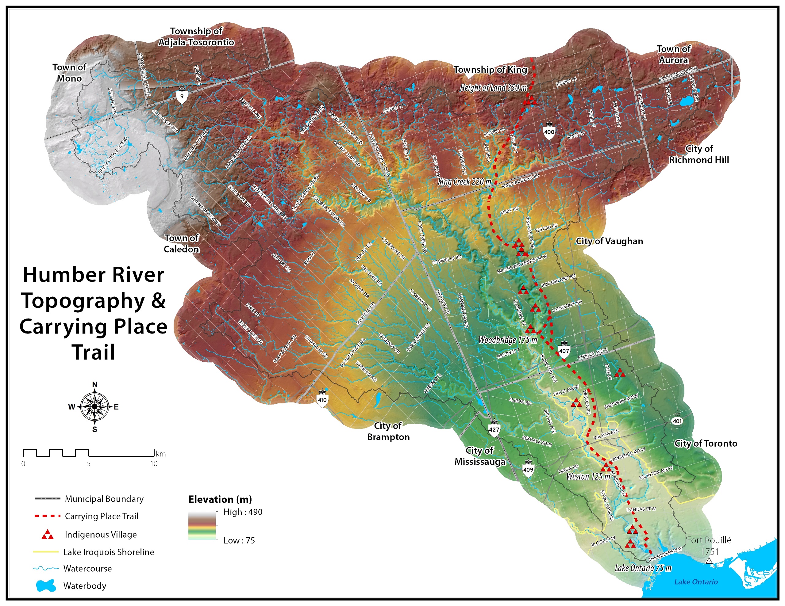
Loop hike in beautiful Niagara Glen, NOT using Whirlpool Trail. We meet in between Niagara Glen parking lot and building near lot. Pay parking or Niagara parks pass. Trail ranges from moderate to quite rocky, has hills and stairs. Watch footing. Lots of boulders and great views close to Niagara River. We descend steel stairs before and after hike. Wear hiking boots or shoes. Bring water, snack, appropriate layered clothing for the weather and rain gear. Optional beverage/food after. Niagara Glen is close to both Butterfly Conservatory and Floral Clock.Power walk along the Humber River Trail (ca 10 km) and optional visit of the McMichael Canadian Art Collection, Kleinburg
https://hikes.brucetrail.org/event/power-walk-along-the-humber-river-trail-ca-10-km-and-optional-visit-of-the-mcmichael-canadian-art-collection-kleinburg/Sorry, the registration cut-off time for this hike has been reached.Not a member? Click here to join today!Hosting Club: Toronto
Category: Car Hike
Location (Google Maps):Hike Leader(s): Natalia Svechnikova Click here to contact Hike Leader(s)
Pace: Brisk (4-5 km/hr)
Terrain: Flat, Level 1 (Easy – mostly on flat, well maintained trails with hard-packed surface), Variable
Distance: 10-11 kmDescription
Please join me for a brisk walk on the Humber River trail strting near the McMichael Canadian Art Collection (main building).The trail has some hills but it is even and easy to walk on. we will walk for about 5 – 5.5 km and return back the same way. It should take us about 2.5 – 3 hours. After we finish, you can spend some time in the gallery and see their newest exhibition”Morrice in Venice” (please check out their website for ore info https://mcmichael.com/upcoming-exhibitions/)
We meet around 10 am near the entrance to the gallery and start hiking at 10:15 am (the trail head is only 50 m away). If you have the McMichael Art Collection membership, you can park free of charge on the gallery’s parking lot. Non-members parking fee is about $7. You can park somewhere in Kleinburg free of charge and walk to the gallery to meet me.
Please be dressed for the weather and wear comfortable shoes. Please bring 2 L of water, rain jacket or umbella and your sun hat, sun galsses. There is no shade on the trail.
You are welcome to reach out if you have any questions.
Please note that the hike will be cancelled if there is a forecast for a heavy rain or storm.
Evening Hike in Owen Sound followed by an Opportunity for Refreshments
https://hikes.brucetrail.org/event/evening-hike-in-owen-sound-followed-by-an-opportunity-for-refreshments-16/Sorry, the registration cut-off time for this hike has been reached.Not a member? Click here to join today!Hosting Club: Sydenham
Category: An evening walk.
Location (Google Maps): Meet in the municipal parking lot by the river on the west side of 1st Ave E between 7th St E and 8th St E in Owen SoundHike Leader(s): Harriet Nixon Click here to contact Hike Leader(s)
Pace: Brisk: 4 to 5 km/h
Terrain: Moderate: Some hills and/or poor footing
Distance: Approx 6 kmDescription
Join us for a brisk evening hike exploring Owen Sound trails and neighbourhoods, followed by an opportunity to socialize over refreshments. There is no need to show up 15 minutes early for this hike, but we will leave promptly at 7:00 pm - 05June 5, 2025
8:00 am Long Hike Cave Spring Conservation Area
https://hikes.brucetrail.org/event/800-am-long-hike-glen-road-jordan-new-time-6/Sorry, the registration cut-off time for this hike has been reached.Not a member? Click here to join today!Hosting Club: Niagara
Location (Google Maps): Cave Springs Conservation Area
Hike Leader(s): Alan Laver Click here to contact Hike Leader(s)
Pace: Medium
Terrain: Moderate
Distance: 10kDescription
Hike the trails around Caves SpringsYou must register for each hike. Bring Poles, snack bug spray, sunscreen and a drink. Dress for the weather
Urban Walk: Valley View Park Thornhill
https://hikes.brucetrail.org/event/urban-walk-valley-view-park-thornhill-82/Sorry, the registration cut-off time for this hike has been reached.Not a member? Click here to join today!Hosting Club: Toronto
Location (Google Maps): Parking lot is inside Sycamore Drive East of Bayview , across Starbucks plaza
Hike Leader(s): Mohammad Aghamiri Click here to contact Hike Leader(s)
Pace: Moderate (3-4 km/hr)
Terrain: Hilly, Level 2 (Intermediate – some hills and uneven surfaces, rocks and roots underfoot)Description
We will explore Valleyview and Maple View parks, and walk along German Mill Creak, in return we stop in Huntington park and have snack under beautiful shed ,Even it is considered Urban walk, it is urban hike as we have some up and down hills and tree roots, please bring your hiking poles, water and snacks,
Hiking in and around Jordan and Balls Falls
https://hikes.brucetrail.org/event/hiking-in-and-around-jordan-and-balls-falls/Sorry, the registration cut-off time for this hike has been reached.Not a member? Click here to join today!Hosting Club: Niagara
Category: Hike
Location (Google Maps): New Location – Parking Lot on Glen Road, JordanHike Leader(s): Bill Russell Click here to contact Hike Leader(s)
Pace: Medium
Terrain: Moderate
Distance: 6-7 kmDescription
Hiking from Glen Road and following Jim Rainforth Trail and trails to Balls Falls and Bailey Bridge.Rail Trail/Dundas Valley CA loop
https://hikes.brucetrail.org/event/rail-trail-dundas-valley-ca-loop/Sorry, the registration cut-off time for this hike has been reached.Not a member? Click here to join today!Hosting Club: Iroquoia
Category: General Hike
Location (Google Maps): Brantford-Hamilton trail crossing near Slote Rd and Mineral Springs RdHike Leader(s): Brenda Davis Click here to contact Hike Leader(s)
Pace: Medium – 3 to 4 km/hr
Terrain: Moderate – Some hills and/or some poor footing
Distance: 15 kmDescription
Join me for a loop hike beginning on the Brantford-Hamilton rail trail. We will follow the path that railway engineers used to descend the escarpment into Dundas Valley Conservation Area, then we will explore some trails in the valley, finally returning via the rail trail to our starting point.Park along the roadside on Slote Rd near the intersection with Mineral Springs Rd.
Please bring enough water, snacks and a lunch. There are washrooms in the Dundas Valley trail centre — we will eat lunch there. We will hike about 15 km return. Please check the weather and dress accordingly — wear hiking boots or trail runners, a hat with a brim, and bring sunscreen. The hike will run, rain or shine.
Harrison Park Loop
https://hikes.brucetrail.org/event/harrison-park-loop-2/Sorry, the registration cut-off time for this hike has been reached.Not a member? Click here to join today!Hosting Club: Sydenham
Category: General Hike
Location (Google Maps): Harrison Park – northwest of km 89.0 BTC Map # 32. Drive east past the restaurantHike Leader(s): Ian Mills
Pace: Medium: 3 to 4 km/h
Terrain: Moderate: Some hills and/or poor footing, There might be muddy sections., There might be sections with water on the trail.
Distance: 10 kmDescription
We will meet at Harrison Park just past the restaurant (east) and follow Harrison Park Side Trail north to the Main Trail. We will follow the Main Trail south to Inglis Falls. Pack a light snack and enjoy some amazing views of the falls. We will follow the Main Trail north to Creamery Side Trail and circle back to our parking area. Interesting terrain, lovely views and good exercise will be provided by this loop. BTC Map # 32. A walking stick is recommended and proper footwear required.
Urban Walk: Toronto Islands Evening Walk
https://hikes.brucetrail.org/event/urban-walk-toronto-islands-evening-walk-15/Sorry, the registration cut-off time for this hike has been reached.Not a member? Click here to join today!Hosting Club: Toronto
Location (Google Maps):
Jack Layton Ferry Terminal, near the gates to Wards Island Ferry. Arrive 20 minutes prior to departure to check in with hike leader.
From Union Station take the LRT and get off at the stop Ferry Docks.Walk up to the Ferry Docks on Queens Quay West, street level. at the foot of Bay Street.
Hike Leader(s): Tom Swales Click here to contact Hike Leader(s)
Pace: Leisurely (2-3 km/hr)
Terrain: Flat
Distance: 6-9 kmDescription
After a day’s work come and “cool off” on the Toronto Islands free of fumes and traffic. Enjoy the view of the city skyline and Toronto’s beautiful island parkland.
Pack a dinner for a sit down picnic. Also bring a warm jacket and flashlight.
Return fare ticket for the ferry is $9.11 for adults, $5.86 for seniors
Hikes will take place rain or shine. If the weather is particularly inclement the day of the hike please check the hike schedule by 10:00 AM for an update.
Toronto Island evening hikes will take place every Thursday in May and June 2025.
Same time and same meeting place. No preregistration is required – just show up at the ferry docks at 5:40 PM and sign in with the hike leader.Tom Swales will lead the hike this evening.
Let's Hike!
https://hikes.brucetrail.org/event/lets-hike-2/Sorry, the registration cut-off time for this hike has been reached.Not a member? Click here to join today!Hosting Club: Iroquoia
Category: Special Event
Location (Google Maps): Grimsby Public Library
18 Carnegie Lane Grimsby OntarioHike Leader(s): Ruth Moffatt Click here to contact Hike Leader(s)
Pace: Leisurely – 3km/hr or less
Terrain: Easy – Mostly flat and usually good footing
Distance: There won’t be any hiking, just info on how to get startedDescription
Are you new to hiking? Would you like a little more guidance to get started?In this workshop we will show you everything you need to get started hiking. It will be led by volunteers from Iroquoia Bruce Trail Club and will include a guidebook to take home as well as a new retro-looking Let’s Hike! badge. One guidebook and badge per person. You must register either through this form or in person.
This session will be repeated on Sunday June 8 at 2pm so if you’re not able to make it on the 5th, please join us on the 8th.
From the trail up, we will discuss footwear, socks, clothing, layering, what to carry in your backpack, hydration, food, hiking hacks, pole and trail etiquette and so much more. Are you ready to get started?
The workshop is 7:00pm – 8:30pm in the lounge of the Grimsby Public Library.
Please join us!
If you have any questions, please reach out through contact on this form.
This presentation is brought to you through a Community of Grimsby Municipal Grant.
- 06June 6, 2025

Car Hike: 22th Annual Excellent Orchid Adventure Weekend (2 overnights)
https://hikes.brucetrail.org/event/car-hike-22th-annual-excellent-orchid-adventure-weekend-2-overnights/Sorry, the registration cut-off time for this hike has been reached.Not a member? Click here to join today!This is a Multi-Day Hike
You are signing up for the following dates and times:
2025-06-06 at
2025-06-07 at
2025-06-08 atHosting Club: Toronto
Category: Car Hike
Location (Google Maps):Princess Hotel
34 Bay St, Tobermory, ON N0H 2R0Hike Leader(s): Jeanette Vincent. Brenda Menezes. David Royle. Click here to contact Hike Leader(s)
Pace: Leisurely (2-3 km/hr)
Terrain: Level 2 (Intermediate – some hills and uneven surfaces, rocks and roots underfoot), Rocky, Variable
Distance (km): 10 – 12 KmDescription
We continue Greg Vincent’s legacy of weekends away. Please join Jeanette Vincent, Brenda and David Royle as we explore the Tip o’ the Bruce, Tobermory in search of orchids and other flowers. Our search will extend to Flowerpot Island (cost approx. $65.00 for the glass bottom ferry and Parks Canada fee). The wildflowers in the Tobermory area at this time of year are wonderful and our slow paced walks will focus on these and other flowers and the area’s great views. We stay and have our meals at a comfortable hotel overlooking Little Tub Harbour. Approximately 10/12km/day.Before registering at the hotel please contact us for the price package of the hotel for the weekend.
This outing is restricted to those staying with us at the Princess Hotel in Tobermory for the weekend – the hotel fills quickly. You will need a car to access this outing. Please contact the Princess Hotel for a reservation.1-519-592-8282 or info@tobermoryprincesshotel.com and mention Vincent/Royle Excellent Orchid weekend.
Toronto BTC End to End Stained Glass Fundraiser
https://hikes.brucetrail.org/event/toronto-btc-end-to-end-stained-glass-fundraiser/Sorry, the registration cut-off time for this hike has been reached.Not a member? Click here to join today!This is a Multi-Day Hike
You are signing up for the following dates:
2025-06-06, 2025-06-07, 2025-06-08Hosting Club: Toronto, Beaver Valley
Location (Google Maps): Meet on the east side of the road where the trail crosses 4th Line. Do not park in front of the junk yard. km 17.4, Map 12 Bruce Trail Guide,, N 43.625638, W 79.990703
Hike Leader(s): Glenda Collings Click here to contact the hike leader.
Pace: Medium
Terrain: Moderate, Some rocky footing, Some steep sections
Length of Hike: Between approx. 17 & 18 kmDescription
Join us for a a 3 day hike to earn the Stained Glass fundraiser badge. The medium hike pace will range between 3 to 4 km per hour, sometimes a bit more than 4 km per hour on easy flat terrain, with a snack and lunch break. Hikers may request a personal bio break, clothing adjustment, drink stop, etc. at any time during the hike by notifying the leader or sweep. The hikes range from approx. 17 to 18 km. Please self evaluate your ability to manage the pace and length of these hikes. Life does happen, so hikers will be able to miss one hike and make it up on their own before the end of June. A full hike schedule, with meet locations, will be sent to hikers after registration. If you have any questions please use the “Contact hike leader” option on the online schedule.
9:00 am Niagara-on-the-Lake Tour
https://hikes.brucetrail.org/event/900-am-niagara-on-the-lake-tour-41/Sorry, the registration cut-off time for this hike has been reached.Not a member? Click here to join today!Hosting Club: Niagara
Category: Urban
Location (Google Maps):Veterans Memorial Park, park just outside the park on King Street
Hike Leader(s): Robin Garrett Click here to contact Hike Leader(s)
Pace: Medium
Terrain: Easy
Distance: 6-7 kmDescription
Each Friday we will explore different neighbourhoods, trails and parkland throughout Historic Niagara-on-the-Lake.Moderate pace with some weeks entirely on sidewalks and roads while others may include a mix of trails and paved pathways. Great way to build up endurance for longer more strenuous hikes.
Prepare for cooler windy conditions on open parkland and along Lake Ontario and Niagara River trails.
Plan to stay for conversation and a warm cup of coffee or tea at Sweets & Swirls, Community Centre, Niagara Stone Road, NOTL
- 07June 7, 2025
School Bus Hike: Loree Forest and Swiss Meadows
https://hikes.brucetrail.org/event/school-bus-hike-loree-forest-and-swiss-meadows/Sorry, the registration cut-off time for this hike has been reached.Not a member? Click here to join today!Trip Information
Departure Time: 08:00
Return to City Time: 19:00
Departure Point: York Mills Bus PickupOptional Items
Pick up at 10 York Mills Rd ($0.01)
Pick up at HWY 400 and Major Mac ($0.01)Hosting Club: Toronto
Category: Bus Hike
Location (Google Maps): Loree Forest and Swiss MeadowsHike Leader(s): Martina Furrer, Roland Mark, Celia Ho, and Duro Vukman Click here to contact Hike Leader(s)
Pace: Moderate (3-4 km/hr)
Terrain: Hilly, Variable
Distance: Moderate group: 14.5 km, fast group: about 16.5 kmDescription
Join us for a great hike in the Beaver Valley. We will split into two groups, a moderate group (led by Celia and Duro) and a faster group (led by Martina and Roland). The moderate group will hike 14.5 km at a 3.5 km/hr pace, the faster group will hike about 16.5 km at 4 km/hr +. We will all stop to enjoy the awesome views of Georgian Bay from various spots along the top of the escarpment. A few fun hills, hopefully some spring wildflowers, and forest cover for shade. Refreshment stop in the Village at Blue Mountain. This area has lots of poison ivy so wear long pants for protection. Also pack a lunch and two litres of water.Departure 1: 8 AM 10 York Mills Rd
Departure 2: 8:20 AM HWY 400 and Major Mac Park and Ride (infront of the GO bus stop)
Car Hike: Scotsdale Farm
https://hikes.brucetrail.org/event/car-hike-scotsdale-farm-12/Sorry, the registration cut-off time for this hike has been reached.Not a member? Click here to join today!Hosting Club: Caledon Hills
Category: General
Location (Google Maps): Scotsdale Farm, Map 13. Directions; from Highway 401, head north on Trafalgar Road past Georgetown. Trafalgar briefly merges with Highway 7 for about 3 km before separating to the right at the village of Silver Creek. At the stop light in Silver Creek, continue north on Trafalgar Road for about 1 km to the entrance of Scotsdale Farm on your right. Drive in about half a kilometre to reach the parking area.Hike Leader(s): Dylan “Lana” Hubbard Click here to contact Hike Leader(s)
Pace: Medium – 3 to 4 km/hour
Terrain: Moderate – some hills and/or some poor footing
Distance: 13 kmDescription
Join us for a loop hike along the main Bruce Trail and its scenic side trails, including the stunning Great Esker Side Trail. After the hike, if enough people are interested, we’ll gather at The Shepherd’s Crook in Georgetown for refreshments and good company.Please dress appropriately for the weather, bring plenty of water, and pack some snacks. Note that parts of the trail are rocky, so poles are highly recommended.
We are committed to fostering an inclusive and welcoming environment. This hike is an LGBTQ+ safe space, and everyone is encouraged to join us!

School Bus Hike: Niagara E2E #6 of 6
https://hikes.brucetrail.org/event/bus-hike-niagara-e2e-6-of-6/Sorry, the registration cut-off time for this hike has been reached.Not a member? Click here to join today!Trip Information
Departure Time: 08:30
Return to City Time: 18:00
Departure Point: Kipling Departure PointOptional Items
Hosting Club: Toronto
Category: Bus Hike
Location (Google Maps): Niagara Section Kms 72.3 to 81.7, plus Beamers Falls Side TrailHike Leader(s): Felix Wan, Tim Wainwright Click here to contact Hike Leader(s)
Pace: Moderate (3-4 km/hr)
Terrain: Variable
Distance: 13.0 kmDescription
Join us for our final walk in the Niagara E2E bus hike series. On today’s hike we’ll start at Mountainview Conservation Area, and cross over Thirty Mile Creek and a small waterfall on our way to Beamer Memorial Conservation Area outside of Grimsby. This marks the end of the Niagara Section of the Bruce Trail, but those who wish to can continue on a loop trail around the conservation area with a side trip to Beamers Falls.There will be a refreshment stop on the way back to Toronto.
Dropout point at 9.4 km.
Bring a packed lunch, two litres of water, and sun/rain/bug protection as needed.
Map 5 in the Bruce Trail Guide
Car Hike: Glasgow village Uxbridge 190
https://hikes.brucetrail.org/event/car-hike-glasgow-village-uxbridge-3/Sorry, the registration cut-off time for this hike has been reached.Not a member? Click here to join today!Hosting Club: Toronto
Category: Car Hike
Location (Google Maps): Glasgow Trail, Concession Road 2 Park in parking lot at the trail head.From Highway 404 turn right to Stouffville Rd, till to the end of road and turn left on York Durham line in About 1km turn right to Webb Rd. and turn right to Concession Road 2 ,you will see parking lot in 500 meters
Hike Leader(s): Mohammad Aghamiri Click here to contact Hike Leader(s)
Pace: Moderate (3-4 km/hr)
Terrain: Hilly, Level 2 (Intermediate – some hills and uneven surfaces, rocks and roots underfoot), Variable
Distance: 14-15 kmDescription
Lets explore Goodwood conservation area and visit Secord forest and pondApproximately 5-hour hike, bring lots of water
Birding Hike
https://hikes.brucetrail.org/event/lets-look-for-bobolinks-2/Sorry, the registration cut-off time for this hike has been reached.Not a member? Click here to join today!Hosting Club: Blue Mountains
Category: Organized Hike
Location (Google Maps): Tim Hortons on First St. in CollingwoodHike Leader(s): Richard Edwards Click here to contact Hike Leader(s)
Pace: Leisurely – 3 km/hr. or less
Terrain: Moderate – Some hills and/or some poor footing
Distance: 6 kmDescription
Please join us for this birding hike, led by birding enthusiasts Dick Edwards and Kate Jaczko. We will carpool to Cty Rd 9 west of Dunedin (map 22, km 10.6) and follow the trail north past a beautiful meadow where bobolinks nest in early June . We will look for singing males defending their territories. Past the meadow, the trail skirts a farm field and descends through forest to the Dunedin Nature Reserve. Here a mix of hardwoods, cedars, and a sparkling stream should provide more birds and spring wildflowers. The trail loops back to con. 10 where we back-track to bobolink meadow and then to our cars having completed 6 km double loop.
Spaces will be limited to 30 hikers, so please register in advance.Remaining Side Trails for the Dufferin Hi-Land Side Trail Badge
https://hikes.brucetrail.org/event/remaining-side-trails-for-the-dufferin-hi-land-side-trail-badge/Sorry, the registration cut-off time for this hike has been reached.Not a member? Click here to join today!Hosting Club: Dufferin Hi-Land
Category: General Hike
Location (Google Maps): Roadside parking on Centre Rd (Kilgorie) 30m south of River Rd, Map 20, 33.8 kmHike Leader(s): Susan Bate, Carol Sheppard Click here to contact Hike Leader(s)
Pace: Medium
Terrain: Moderate
Distance: 16.4kmDescription
To earn the Side Trails badge at the end of this hike, you need to have completed all 6 of the 60th Anniversary Side Trails Highlights Series either with the group or by logging your side trails hikes.Today, starting from the parking area in Kilgorie, we will carpool to the parking lot on 30th sideroad just south of Lavendar. Here we will do a 1.4km loop hike that takes us to our most northern side trail, Black Edge. We will return to Kilgorie, hiking the Kilgorie Side Trail. Next, we’ll visit the Bell Lookout Side Trail with its view of the Pine River Valley, travel through the Pine River Valley and Carl Alexander Side Trails. Returning to the Main Trail, we will hike north to the Melodonna Side Trail and back. We will take the Kilgorie Side Trail back to our cars.
Bring water, snacks/lunch and insect repellant as well as sunscreen. Hiking poles are recommended. Carpooling is preferred for the first leg of the hike.
Car Hike: Humber Valley Heritage Trail - 17KM
https://hikes.brucetrail.org/event/car-hike-humber-valley-heritage-trail-17km/Sorry, the registration cut-off time for this hike has been reached.Not a member? Click here to join today!Hosting Club: Toronto
Category: Car Hike
Location (Google Maps): Dicks Dam Park, BoltonHike Leader(s): Alina Lin
Pace: Brisk (4-5 km/hr)
Terrain: Challenging, Hilly, Level 2 (Intermediate – some hills and uneven surfaces, rocks and roots underfoot), Variable
Distance: 17 KMDescription
Humber Valley Heritage Trail near Bolton is a scenic and historically rich trail that follows the Humber River Valley, offering a variety of hiking experiences for nature enthusiasts. The trail traverses diverse landscapes, offering not only a mix of terrains, including forests, meadows, and riverbanks, but also historic plaques and landmarks, such as various parks that highlight the area’s rich history. And if you were wondering, yes it is the same Humber River as the Humber River runs through Toronto to lake Ontario!This will be a go and back hike on the Humber Valley Heritage Trail along the Humber River. Here is the map for your reference: https://onthegomap.com/s/qppe2v4a. A few notes for your attention and preparation:
- Meet at the parking lot of the Dicks Dam Park at GPS (43.879318, -79.747802).
- Arrive before 8:45am. The group will depart at 9:00am.
- Dress for weather and wear sturdy hiking shoes or boots.
- Bring snack or light lunch and at least 1L of water. We will have a short break for lunch after reaching turning point.
- No pets

Urban Walk: Toronto Urban Badge Hike - 6 of 7
https://hikes.brucetrail.org/event/urban-walk-toronto-urban-badge-hike-6-of-7/Sorry, the registration cut-off time for this hike has been reached.Not a member? Click here to join today!Hosting Club: Toronto
Category: Urban Walk
Location (Google Maps): East Don River TrailHike Leader(s): Brian Rideout Click here to contact Hike Leader(s)
Pace: Moderate (3-4 km/hr)
Terrain: Flat
Distance: 9 kmDescription
Please join me at the south east corner of Sheppard Ave East and Leslie by 10 AM. We will hike south through several parks to Don Mills (S of Overlea) (km 51.7 to km 62.4). Here is an online map with km markings of our route for all 7 hikes for the Toronto Urban Badge: https://onthegomap.com/s/c2c1hf3nPlease make sure you bring at least 2 liters of water, a lunch, bug spray and sunscreen.

Mayor's Walk - Grimsby 9:45am
https://hikes.brucetrail.org/event/mayors-walk/Sorry, the registration cut-off time for this hike has been reached.Not a member? Click here to join today!Hosting Club: Iroquoia
Category: Mayor’s Walk
Location (Google Maps): Please arrive by 9:45 for check-in, Lion’s Club Pool parking lot 1 Elm Street, GrimsbyHike Leader(s): Ruth Moffatt Click here to contact Hike Leader(s)
Pace: Medium – 3 to 4 km/hr
Terrain: Dependent on Conditions, Strenuous – Hilly with steep climbs and some poor footing
Distance: 4-5kmDescription
In cooperation with Ontario Trails Council, we are pleased to participate in the Mayor’s Walk.Please join Grimsby Mayor, Jeff Jordan for the Mayor’s Walk. This hike will take us from the parking lot, up Gibson Street and up the Iroquoia Bruce Trail and around to the hawk watch area and back to the pool parking lot. Please expect the distance to be about 4-6km and to take up to 2 hours. The hike up the hill is strenuous and would not be suitable for individuals who are not used to climbing.
If you’d like to avoid the uphill climb, you can meet us in the parking area off of Quarry Rd. We should arrive there at about 10:30-10:45am. Your hike will be shorter.
Please bring enough water and snacks and wear suitable hiking footwear.
Pride on the Trail: A Rainbow Hike for All
https://hikes.brucetrail.org/event/pride-on-the-trail-a-rainbow-hike-for-all/Sorry, the registration cut-off time for this hike has been reached.Not a member? Click here to join today!Hosting Club: Peninsula
Category: Rainbow Hike
Location (Google Maps): Halfway Log Dump Parking Lot, Bruce Peninsula National ParkHike Leader(s): Marg Glendon & Tainin Hopkinson Click here to contact Hike Leader(s)
Pace: Leisurely (2.0 – 3.0 km/h): A relaxed pace with frequent breaks and a focus on enjoyment., Medium (3.0 – 4.5 km/h): A comfortable pace for most hikers with steady progress.
Terrain: Difficult: Steep ascents/descents, rocky scrambling, and some rugged escarpment paths., Easy: Flat forested sections or lowland trails., Moderate: Rolling hills, mild slopes and rocky paths.
Distance: 2 km or 6 kmDescription
Join us for a family-friendly Rainbow Hike for 2SLGBTQ+ folx and allies at Halfway Log Dump. A Bruce Peninsula National Park Interpreter will accompany us on our hike, sharing information about the unique ecosytem here and providing examples of Queer Ecology in Nature. Meet at the Halfway Log Dump parking lot at the entrance to Halfway Log Dump Side Trail .Here, the Bruce Trail winds through the beautiful Bruce Peninsula National Park. Our first 1 km of hiking will be on generally flat terrain bringing us to the pristine, aquamarine water of the Georgian Bay shoreline. Here we will take time to enjoy the view and soak in the sensational signs of Spring, have lunch and explore the shore. Then, for those wishing to hike the more rugged section of the trail, we will continue north covering some demanding terrain. Good balance and stamina is required for walking this section of the trail. This out and back hike portion of the afternoon will be about 1 ½ hour in duration. Upon returning to the rest of the group at the shoreline, we will take a few minutes to share our experiences with one another. If you would prefer to continue gently exploring the shoreline rather than the longer hike, a PBTC Hike Leader will stay with this group and remain here until the other hiking group returns. If participants would like to linger longer, the rest of the group will say goodbye and return to our vehicles via Halfway Log Dump Sidetrail. In total, our hiking afternoon will take about 3 ½ hour. Outdoor compost toilets are available at the parking lot and at the shoreline. Bruce Peninsula National Park fees for admission and parking apply. No parking reservation is required at this time of year.Weather can be unpredictable at this time of year. Wear layers, hat, sturdy footwear with good tread and closed toes.
Bring a back pack for snacks and lunch, water bottle, blanket for sitting, hiking poles and binoculars (optional).
Interested in extending your day? Join us at the Bruce Peninsula National Park Visitor’s Centre for an informative presentation about the beauty and diversity of bird species on the Saugeen Peninsula, and current research about resident and migrating bird species living here. No registration required. Free!
Indigenous learning at Terra Cotta
https://hikes.brucetrail.org/event/indigenous-learning-at-terra-cotta/Sorry, the registration cut-off time for this hike has been reached.Not a member? Click here to join today!Hosting Club: Caledon Hills
Category: General
Location (Google Maps): Terra Cotta Conservation Area, off Winston Churchill Blvd. within the Conservation Area.Hike Leader(s): GG Click here to contact Hike Leader(s)
Pace: Leisurely – 3 km/hour or less, Medium – 3 to 4 km/hour
Terrain: Moderate – some hills and/or some poor footing
Distance: approx. 5km (or more depending on interest!)Description
Looking for an Indigenous learning and hike outing? Join us as we learn about the Sweat Lodge at Terra Cotta, explore the amazing wetland area and read “Nibi’s water song” tales on the trail.Park entry requires gate admission https://cvc.ca/credit-valley-parks/admissions-and-reservations/
Please wear appropriate gear, hiking boots, poles, and bring snacks and water. There are washrooms on site.
Join us as we enjoy, learn and appreciate together
Youth Hiking Program - Discovery Hike - Cottonwood Loop
https://hikes.brucetrail.org/event/youth-hiking-program-discovery-hike-cottonwood-loop-3/Sorry, the registration cut-off time for this hike has been reached.Not a member? Click here to join today!Hosting Club: Sydenham
Category: Family Hike
Location (Google Maps):Roadside parking on the east side of 11 Line, approximately 3 km north of Highway 26, at the entrance to the Cottonwood Side Trail, Map 30, Edition 31
Carpooling may be available upon request.
Hike Leader(s): Jeannine Kralt Click here to contact Hike Leader(s)
Pace: Leisurely: 3 km/h or less
Terrain: Easy: Mostly flat and good footing.
Distance: 2.1kmDescription
This hike will be a discovery hike along the Cottonwood Loop – we’ll take our time, and see what we can find. This trail is a stand-alone trail, separate from the rest of the Bruce Trail. We’ll hike through forests, near a hidden waterfall, past a particularly large cottonwood tree, and to a lookout along a ridge. This property is the original location of the Rows homestead – their farmhouse can be seen at Moreston Village at Grey Roots.The Cottonwood Loop counts towards the Junior Hiker badge and is also featured in Ron Savage’s new book, Exploring Sydenham. There will be sufficient time to find the related code en route. It’s also a great trail to use for the By the Seasons badge.
As we’ll be taking our time, this hike is suitable for families, new hikers, and anyone wanting a more leisurely hike – all ages are welcome. We’ll likely take upwards of a couple of hours, depending on the group – dress in layers, bring a snack, and wear good footwear. An email re: trail conditions to expect will be sent out prior to our hike together. We’re hoping for a lovely late spring hike!
If you are unable to register, or if you have any questions/concerns, please contact the hike leader (Jeannine) via the link above. Parking is roadside. Carpooling may be available upon request.