Categories
- 14June 14, 2025
Car Hike: Oak Ridges Trail King City
https://hikes.brucetrail.org/event/car-hike-oak-ridges-trail-king-city/Sorry, the registration cut-off time for this hike has been reached.Not a member? Click here to join today!Hosting Club: Toronto
Category: Car Hike
Location (Google Maps): Around 14020 Keele Street KingPark along Road gathering beside trail head
Hike Leader(s): Mohammad Aghamiri Click here to contact Hike Leader(s)
Pace: Moderate (3-4 km/hr)
Terrain: Hilly, Level 2 (Intermediate – some hills and uneven surfaces, rocks and roots underfoot)
Distance: 12-14 kmDescription
We will hike 2 loops ,first on east side towards Sceneca Lake ,then on the west to Mary Lake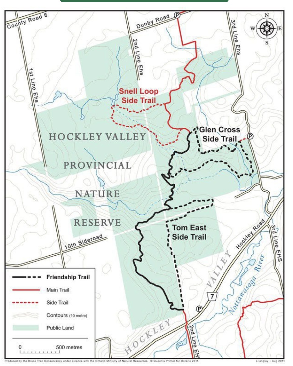
Jeju Ole International Friendship Hike
https://hikes.brucetrail.org/event/jeju-ole-international-friendship-hike/Sorry, the registration cut-off time for this hike has been reached.Not a member? Click here to join today!Hosting Club: Caledon Hills
Category: General
Location (Google Maps): Meet at Hockley Road Parking Lot
43.972857, -80.056330Directions: From ON-10 head east on Hockley Road/Dufferin County Road 7 for 5 kilometres
Hike Leader(s): Sandy Green Click here to contact Hike Leader(s)
Pace: Medium – 3 to 4 km/hour
Terrain: Moderate – some hills and/or some poor footing
Distance: 6.0 kilometres or 11.5 kilometresDescription
All are welcome to join members and friends of the Caledon Hills Club and Sansamo Korean Hiking Club to explore the Jeju Olle Friendship Trail located in the Hockley Valley Provincial Nature Reserve. This Bruce Trail Conservancy International Friendship Trail is twinned with the Jeju Olle walking trail located on the island of Jeju, South Korea. Bring water and a snack. Sturdy shoes are recommended. We are offering two distances for everyone’s enjoyment.Beaver Valley Geology Hikes Badge Hike total 8
https://hikes.brucetrail.org/event/beaver-valley-geology-hikes-badge-hike-1-8-2/Sorry, the registration cut-off time for this hike has been reached.Not a member? Click here to join today!This is a Multi-Day Hike
You are signing up for the following dates and times:
2025-06-14 at 09:00
2025-07-05 at
2025-07-23 at
2025-08-02 at
2025-08-20 at
2025-09-03 at
2025-09-20 at
2025-10-01 atHosting Club: Blue Mountains
Category: Organized Hike
Location (Google Maps): Tim Hortons on First St. in Collingwood.Hike Leader(s): Annette Sandberg Click here to contact Hike Leader(s)
Pace: Medium – 3 to 4 km/hr
Terrain: Moderate – Some hills and/or some poor footing
Distance: 7.1Description
This badge is earned by hiking each of 8 hikes outlined in Beth Gilhespy’s first Bruce Trail Geology book, Walking Through Time, and then submitting a log which includes the required
photo taken during each of the hikes. This is a great opportunity to boost your knowledge of the geology of the Niagara Escarpment. Gather some hiking buddies and become rock
hounds!Visit and take a photograph of 8 features profiled in Walking Through Time:
1. June 14 – Len Gertler Memorial Loree Forest: Natural Arch at Stop 4 (Pages 47/48)
Natural arches are created when water pounding against a cliff face exploits cracks and crevices, gradually
wearing the rock away. Natural arches can become flowerpots if erosion continues. Thousands of years ago
the level of the Great Lakes was significant higher and lapped up against the promontory of Loree Forest.
2. July 5 – Margaret Paull and Indian Brook: Flowerpot at Stop 2 (Page 52)
Flowerpots are created by water that exploits cracks and eventually removes the material between the flowerpot and the main rock face. The water smooths and rounds the rock of the flowerpot. The flowerpots at Indian Brook were created several thousands of years ago when lake levels were significantly higher than they are today.
3. July 23 – The Mill Creek Valley: “Castle Ramparts” at Stop 8 (Pages 63/64)
The Manitoulin Dolostone layer of the Niagara Escarpment forms a steep edge along the valley of Mill Creek.Over time the thinly bedded rock breaks away from the cliff face and lies scattered along the slope. Many shell and horn coral fossils can be found in these flat, shingle-like rocks. Note that when leaves are fully out
in the summer months the “castle ramparts” may be hard to see. A photograph of the talus rock below the cliff will be sufficient for this badge location.
4. August 2 – Fox Ridge and McClusky’s Rock: Badland at Stop 4 (Pages 72/73)
Queenston Shale is the bottom-most layer of the Niagara Escarpment. Where vegetation is removed, the shale appears as a “badland”. The brick-red shale has long been excavated along the Niagara Escarpment to make bricks.
5. August 20 – Falling Waters: Waterfall on Stew Hilts Side Trail at Stop 3 (Page 86)
At the lovely waterfall on the Stew Hilts Side Trail water trickles over the hard Manitoulin Dolostone layer and falls onto the soft Queenston Shale.
6. September 3 – Wodehouse Karst (Southern Route): Rock Outcrop in Bowles Gully at Stop 9 (Pages 98-100)
At Bowles Gully two Escarpment rock layers – the Amabel Dolostone and the Manitoulin Dolostone – outcrop along the sides of the steep ski hill.
7. September 20 – Wodehouse Karst (Northern Route): Fossil in the Barn Foundation on Stone Foundation Side Trail at Stop 6 (Pages 95-97)
Barn Foundations are wonderful places to see many different rock types, including the Escarpment’s Fossil Hill Dolostone layer, which is full of coral and other fossils.
8. October 1 – Griersville to Webwood Falls: Erratic boulders at Stop 4 (Page 109)
Glacial erratics are rocks picked up by glaciers and transported great distances to be left behind as the glacier melts. These erratic boulders are 1 billion years older than the local sedimentary bedrock, and originally came from the Canadian Shield.
School Bus Hike - A Day at the Beach!
https://hikes.brucetrail.org/event/school-bus-hike-a-day-at-the-beach/Sorry, the registration cut-off time for this hike has been reached.Not a member? Click here to join today!Trip Information
Departure Time: 09:00
Return to City Time: 18:00
Departure Point: Kipling Departure PointOptional Items
Hosting Club: Toronto
Category: Bus Hike
Location (Google Maps): Wasaga Beach – Beach Area 6Hike Leader(s): Marijo Roy Click here to contact Hike Leader(s)
Pace: Moderate (3-4 km/hr)
Terrain: Flat, Level 1 (Easy – mostly on flat, well maintained trails with hard-packed surface)
Distance: 8 kmDescription
Please join us for a day at Wasaga Beach. We will walk along the longest freshwater beach in the world, from Beach Area 6 to Beach Area 1.We will follow part of the Waterfront Trail, encompassing some flat paved and sandy roads. There are several public washrooms along the way. After the hike, you can enjoy swimming, visit the Nancy Island Historic Site to learn more about the War of 1812, or sightsee the area.
There will be no drop-off. Please ensure you are comfortable walking 8 km at a moderate pace.
Please bring your lunch, snacks, at least 2L of water, sun protection, hat, swimming suit and towel (if applicable), medications, and a First Aid kit.
Back in Toronto, Kipling subway station at 6:00 p.m., traffic dependent.
Nancy Island Historic Site
https://wasagabeachpark.com/nancy-island-historic-site/
Geology Hike #10 Savage Wells
https://hikes.brucetrail.org/event/geology-hike-10-savage-wells/Sorry, the registration cut-off time for this hike has been reached.Not a member? Click here to join today!Hosting Club: Sydenham
Category: Geology Hike
Location (Google Maps): Meet and park at the gravel parking area at “Ben Allen” at the intersection of Grey Road 17 and Gordon Sutherland Parkway. We will carpool and drive a short distance north to the trailhead.Hike Leader(s): Carol Graham-Mullin Click here to contact Hike Leader(s)
Pace: Leisurely: 3 km/h or less
Terrain: Easy: Mostly flat and good footing., Moderate: Some hills and/or poor footing, Strenuous: Hilly with steep climbs and some poor footing.
Distance: 5.6 kmDescription
This is Geology Hike # 10 as described in Beth Gilhespy’s book, “Walking Through Time Exploring Niagara Escarpment Geology in the Sydenham Bruce Trail Section”. This is a delightful loop hike through the forest featuring wetlands, “wells”, erratics, fossils and views across the Glen.Please bring water, snacks and poles if needed. The hike leader will have signed copies of Beth’s book for sale (cash, cheque or e-transfer). A Sydenham Bruce Trail Geology Badge has been developed. Details can be shared from hike leader during hike.
Car Hike: Uxbridge Countryside Preserve and A Stroll to Little Thief Bakery
https://hikes.brucetrail.org/event/car-hike-uxbridge-countryside-preserve-and-a-stroll-to-little-thief-bakery/Sorry, the registration cut-off time for this hike has been reached.Not a member? Click here to join today!Hosting Club: Toronto
Category: Car Hike
Location (Google Maps): We will start in the Countryside Preserve Trailhead ParkingHike Leader(s): KJ Chong Click here to contact Hike Leader(s)
Pace: Moderate (3-4 km/hr)
Terrain: Flat, Level 2 (Intermediate – some hills and uneven surfaces, rocks and roots underfoot), Variable
Distance: 10.5 kmDescription
Join us for a delightful stroll through forests and grassy meadows. The hike will feature a look out park in the meadows. Then we will continue on to walk into the old downtown area of Uxbridge to Little Thief Bakery for some delightful treats. While we love furry friends, but please leave your dogs at home.
Chi-Cheemaun Festival - Burnt Point Loop Side Trail Hike
https://hikes.brucetrail.org/event/chi-cheemaun-festival-burnt-point-loop-side-trail-hike/Sorry, the registration cut-off time for this hike has been reached.Not a member? Click here to join today!Hosting Club: Peninsula
Category: Peninsula Blue Series
Location (Google Maps): Bruce Trail Cairn, Bay Street, TobermoryHike Leader(s): Shawn Radcliffe Click here to contact Hike Leader(s)
Pace: Leisurely (2.0 – 3.0 km/h): A relaxed pace with frequent breaks and a focus on enjoyment.
Terrain: Easy: Flat forested sections or lowland trails., Moderate: Rolling hills, mild slopes and rocky paths.
Distance: 5.0 kmDescription
Chi-Cheemaun Festival – Bruce Trail Hike. We will hike the Main Bruce Trail from the cairn in Tobermory to the Burnt Loop Side Trail.This is a lovely hike through an enchanting forest with pretty views of Georgian Bay, Flower Pot, and Bear’s Rump Islands taking approximately 3 hours. We will hike at steady pace with brief stops for drinks/snacks and water views.
The terrain on the first part of this trail is level, however the Burnt Loop Side Trail is a meandering, rocky trail with some short ups and downs and includes a short rocky beach section.
We will end at the Visitor’s Centre in the Bruce Peninsula National Park.
Make sure to wear appropriate clothing, and hiking boots or sturdy walking/running shoes. Bring a light backpack for water and snacks.
Car Hike: Scotsdale Farm
https://hikes.brucetrail.org/event/car-hike-scotsdale-farm-11/Sorry, the registration cut-off time for this hike has been reached.Not a member? Click here to join today!Hosting Club: Toronto
Category: Car Hike
Location (Google Maps): Scotsdale Farm, Map 13Hike Leader(s): Al Brown Click here to contact Hike Leader(s)
Pace: Moderate (3-4 km/hr)
Terrain: VariableDescription
We will complete a loop hike along the main and side trails in Scotsdale Farm and Silver Creek Conservation Area. The trail passes through varied terrain consisting of farm lanes/fields, glacial formations, etc. Most of the trail is under the forest canopy.To get to the meeting point drive north on Trafalgar Road past Georgetown. Trafalgar Road merges with Hwy 7 for 4 km. At Silver Creek turn right at the stop lights and proceed north on Trafalgar about 1.5 km to the entrance. The parking area and meeting point is about 0.5 km from the road.
After the hike there will be a refreshment stop in old Georgetown.

10:00 Malivoire Wine Co Hike and Wine Tasting Experience
https://hikes.brucetrail.org/event/1000-malivoire-wine-co-hike-and-wine-tasting-experience-2/Sorry, the registration cut-off time for this hike has been reached.Not a member? Click here to join today!Hike open to BTC Members only.
Hosting Club: Niagara
Category: Loop
Location (Google Maps): Park at Malivoire Wine Co 4260 King St, Lincoln ONHike Leader(s): Sam Rutherford Click here to contact Hike Leader(s)
Pace: Medium
Terrain: Moderate
Distance: 5 kmsDescription
We will hike a loop on the main trail from Malivoire Wine Co to the Margaret Reed Side Trail at Cave Springs Conservation Area and back to Malivoire Wine Co by 11:30. Upon return we will enjoy a private structured wine tasting led by one of the knowledgeable and friendly winery staff from 11:30 to 12:00 noon. The cost for the tasting experience is $12.00 per person. Please bring your $12.00 with you as I will collect it prior to the tasting to simplify the payment to Malivoire Wine Co. Thank you.
Urban Walk: Toronto Urban Badge Hike - 7 of 7
https://hikes.brucetrail.org/event/urban-walk-toronto-urban-badge-hike-7-of-7/Sorry, the registration cut-off time for this hike has been reached.Not a member? Click here to join today!Hosting Club: Toronto
Category: Urban Walk
Location (Google Maps): Don River/Bayview Extension TrailsHike Leader(s): Brian Rideout Click here to contact Hike Leader(s)
Pace: Moderate (3-4 km/hr)
Terrain: Flat
Distance: 9 kmDescription
Please join me at the south east corner of Overlea Blvd and Don Mills Rd by 10 AM. We will hike south on the Don Trail to the Distillery District (km 62.4 to km 71.4). Here is an online map with km markings of our route for all 7 hikes for the Toronto Urban Badge: https://onthegomap.com/s/c2c1hf3nPlease make sure you bring at least 2 liters of water, a lunch, bug spray and sunscreen.
Dundas Valley Loop
https://hikes.brucetrail.org/event/dundas-valley-loop-4/Sorry, the registration cut-off time for this hike has been reached.Not a member? Click here to join today!Hosting Club: Iroquoia
Category: General Hike
Location (Google Maps): Dundas Valley Conservation Area, DundasHike Leader(s): Anne Armstrong Click here to contact Hike Leader(s)
Pace: Leisurely – 3km/hr or less
Terrain: Dependent on Conditions, Moderate – Some hills and/or some poor footing
Distance: Approx. 10 km.Description
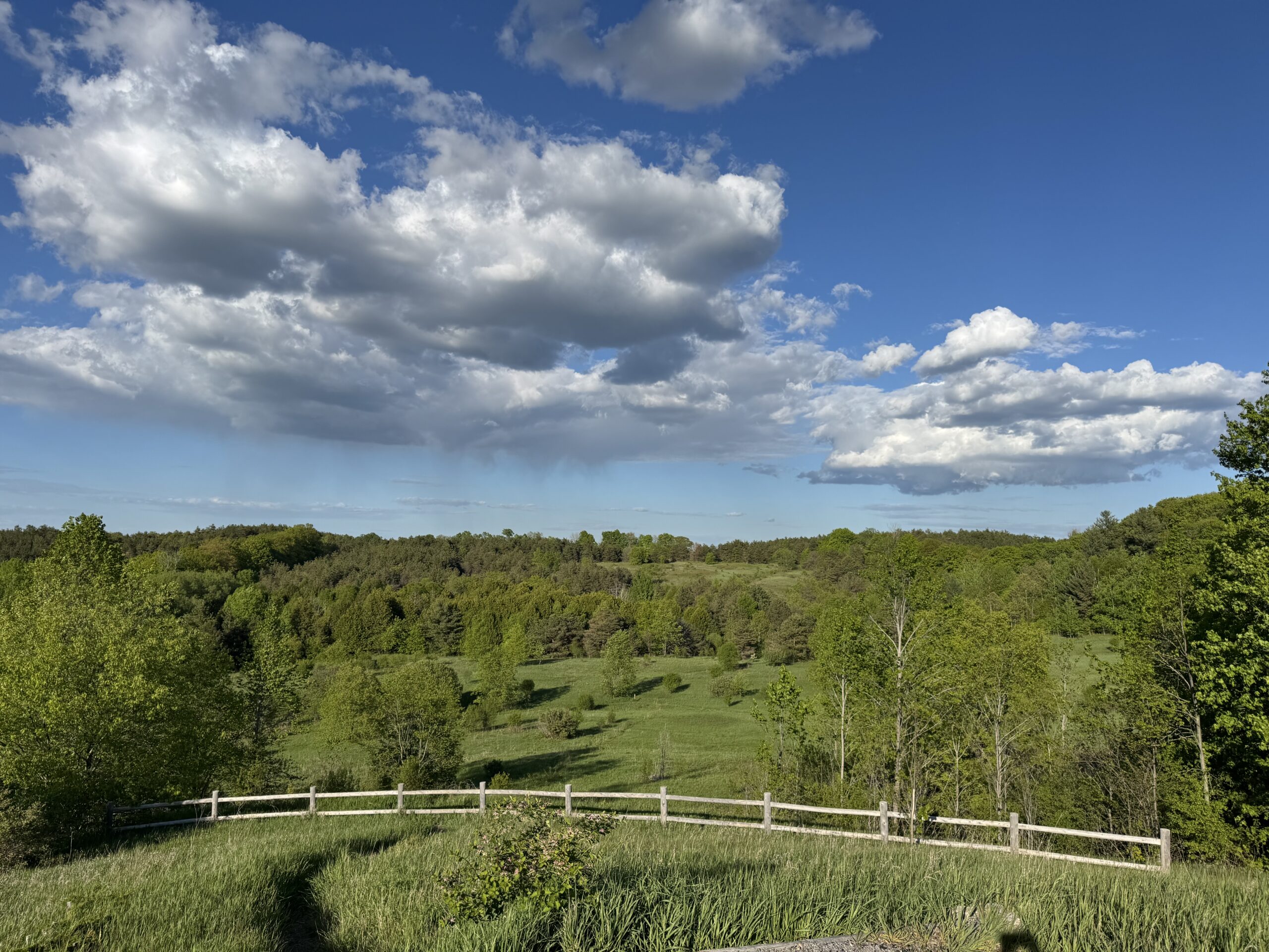
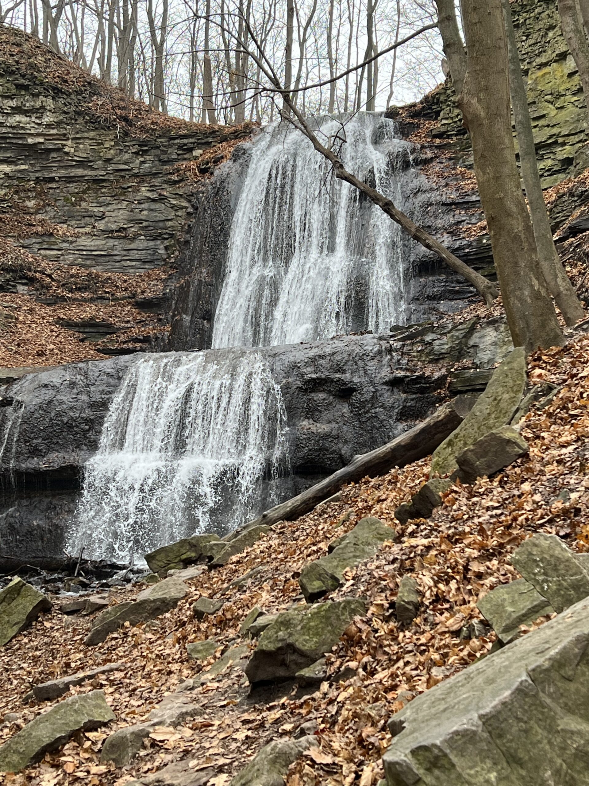
Join in this loop hike which visits several waterfalls including the beautiful Sherman Falls which is spectacular if there is a lot of water. Meet in the last parking lot of the Dundas Valley Conservation Area on Governors Rd. west of Dundas at 9:45 am. for a 10:00 am. start. Bring water, a snack, sunscreen and insect repellent. Hiking poles might be useful for the hills we will encounter. Parking fee in effect or a Conservation Area pass.Forest Bathing - Leading to Summer Solstice
https://hikes.brucetrail.org/event/forest-bathing-leading-to-summer-solstice/Sorry, the registration cut-off time for this hike has been reached.Not a member? Click here to join today!Hosting Club: Dufferin Hi-Land
Category: Nature Walks
Location (Google Maps): Dufferin Hi-Land section, BTC Reference Guide, Map 20. Meet at the parking area on the 30th Side Road, 1.75 km east of Hurontario St., at km 12.2. For the second part of the walk, we will meet at the Bruce Trail parking lot on the 1st Line East, at km 28.3, (emergency road address # 716599).Hike Leader(s): Janice McClelland Click here to contact Hike Leader(s)
Pace: Leisurely – 3 km/hour or less
Terrain: Moderate – some hills and/or some poor footing
Distance: 6.1 kmDescription
As we lead into the Dufferin Hi-Land summer solstice events, an invitation for experienced Forest Bathers to drink in the long, pastoral views of high fields (5 km) and then the cozy trail through forest with its interesting biological and geological features, including a natural stone bridge (a 1.1 km loop). We will observe quiet during the walk itself so that all can benefit from the unique experiences on both parts of this Forest Bathing walk. Note: we will meet on the 30th Side Road and walk south on the main trail and return to our cars on this out & back part of the day. We will then drive 7 km north from the first part of our hike to the Bruce Trail parking lot on the 1st Line East, departing from there for our second walk of the day – a loop of 1.1 km. Please bring water & lunch.