From Jordan Hollow Hike the main trail to Upper and Lower Balls Falls, Moyer Road or Louth and Return. You must register for each hike. Dress for the weatherBring Poles, snack a drink and ices
Description This hike follows the east bank of Twelve Mile Creek to downtown then back and continues on the side trail towards Brock University until it meets the Main Trail and then back. Counts towards the NBTC Side Trail badge. Required photos include: Graffiti under the bridges, Twelve Mile Creek, Pedestrian bridge over Hwy 406. This hike is for anyone who just wants to enjoy this unique side trail as well as those working towards the Side Trail badge.
Hosting Club: Iroquoia Category: Thursday Group Location (Google Maps): Meet at the end of Wesley Avenue and park on the grass along the east / right hand side of the road for a 9:30 departure. We will hike through the RBG Berry Track and the HNC Cartwright property go up to the Borer Falls parking lookout and back. To get to Wesley Avenue, drive along Valley Road or Old Guelph Road, turn onto Patterson Road and Wesley will be to your south. See Map 9 in the BTC guide.
Hosting Club: Sydenham Category: General Hike Location (Google Maps):
Roadside parking on Gleason Lake Rd at the corner of Colpoy’s Range Rd (where the Curly Harnden and Len Holley Side Trails meet), south of km 163.1 (Map 35)
Pace: Medium: 3 to 4 km/h Terrain: Moderate: Some hills and/or poor footing Distance: 6 km
Description This loop hike begins with the Len Holley Side Trail, then follows the snowmobile trail to the Skinner’s Woods Side Trail. We will return to our cars via the Len Holley Side Trail. Bring a snack. Approx. 3 hours.
Description Get your cameras ready for the Annual Winter Festival of Lights hike. Meet at the Floral Showcase along the Niagara Parkway (parking fees apply – annual pass for the Parkway is the best deal). Get into the festive mood with this walk around the Falls area. Stay afterwards to share hot apple cider and treats. You are welcome to share your favorite holiday treat.
Description Each Friday we will explore different neighbourhoods, trails and parkland throughout Historic Niagara-on-the-Lake.
Moderate pace with some weeks entirely on sidewalks and roads while others may include a mix of trails and paved pathways. Great way to build up endurance for longer more strenuous hikes.
Prepare for cooler windy conditions on open parkland and along Lake Ontario and Niagara River trails.
Plan to stay for conversation and a warm cup of coffee or tea at Sweets & Swirls, Community Centre, Niagara Stone Road, NOTL
Hosting Club: Niagara Category: Car Pool Location (Google Maps): 102.6 to 87.3 West side of 5147 Walkers Line Across from Cemetery. N43.419107 W79.861377 Carpool to Twiss Road Roadside Parking.102.6 N43.447743 W79.953436 Paid Parking
Hosting Club: Toronto Category: Car Hike Location (Google Maps): Boyd Conservation Park Vaughan Park for free in parking lot before park entrance on Islington Avenue
Hosting Club: Sydenham Category: General Hike Location (Google Maps): The Galaxy Theatre parking lot. Meet in the parking lot at the tall “Galaxy Centre” sign next to the traffic lights. 1020 10th St. W., Owen Sound
Pace: Medium: 3 to 4 km/h Terrain: Moderate: Some hills and/or poor footing Distance: 5.5 kms
Description We will hike on the blue Don Richards Side Trail to the white trail, which will take us to The Cedar Point Side Trail. We then follow the trail south to the Kemble Wetland Trail, back to the cars. Map 34. Hiking time approx. 2 hrs. Poles advised. Please contact hike leader if not interested in car pooling.
Hosting Club: Blue Mountains Category: Register on-line or sign-in morning of hike Location (Google Maps): Hike meets in the parking lot behind Tim Hortons on First St. in Collingwood.
Pace: Medium – 3 to 4 km/hr Terrain: Moderate – Some hills and/or some poor footing Distance: 8km
Description We will head to Dunedin Valley Nature Preserve parking on 6/7 Sideroad at Conc. 10. Following the white blazed trail south on Conc. 10, we enter the nature preserve on the east side. This area covers mixed terrain and provides a chance to experience a variety of habitats. The trail goes along the banks of a tributary of the Noisy River. After crossing Conc.10, we proceed through some farmers fields to a great view at the bench. We will then return following the road. Bring a snack or lunch and water. Map 21 Ed. 30
Pace: Medium – 3 to 4 km/hr Terrain: Strenuous – Hilly with steep climbs and some poor footing Distance: 12-14 kms
Description We will meet at the green x-see map-the far side of Walmart parking near the trucking laneway-we will walk down this laneway to the back of the store and walk along edge of quarry
to the Bruce trail following the white blazes east to Smokey Hollow ending at Grand Falls-Moderately difficult – some rocky and steep sections- and stairs to view the falls-
We will take a lunch break at the river and then head back same route along Grindstone Creek- Important to bring ICERS, hiking poles, water, snacks, appropriate footwear and clothing
Any questions or concerns, please text or email me Cathie 416 931 2095 cathiekygreen@gmail.com
Description This easy hike will walk out along the Cape Chin Side Trail and return via the main trail along the beach. If all hikers are interested, we will add an additional 1 km to hike to the lookout at Smokey Head and back. Total time commitment is about 2 hours.
Pace: Leisurely – 3km/hr or less Terrain: Moderate – Some hills and/or some poor footing Distance: Approx. 9 km.
Description Meet in the parking lot at 9:45 am. for a 10:00 am. start to join us for a ramble around the Hilton Falls Conservation Area with its many trails, from easy to more challenging. We will circle the lake and continue on to the Falls. From there we will venture into the Halton Agreement Forest and return to the main Conservation Area trails. We will see the remnants of the mill that used to operate at the Falls. Expect some rocky, uneven terrain. Bring water and a snack. Poles will be useful. Depending on conditions icers might be necessary. Note: Registration required via the Halton Conservation Authority website. Leader: Anne Armstrong 905 617 3937 hikingrandma@gmail.com
Hosting Club: Toronto Category: Car Hike Location (Google Maps): Scotsdale Farm main and side trails.
Directions: North on Trafalgar Road past Georgetown to Hwy 7. Northwest of & to Silver Creek. Turn right onto Trafalgar Road. Go north about 1.5 km. The parking area is about 0.5 km from the Trafalgar Rd.
Description We will hike along the main and side trails on Scotsdale Farm including the newly opened section connecting to the Duff Pit Side Trail. Hike length is flexible and will be based on weather.
After the hike those interested are invited to join me for refreshments at the Sheppard’s Crook in the of centre of Georgetown.
Hosting Club: Toronto Category: Urban Walk Location (Google Maps): Meet outside south exit of Markham Pan Am Centre by the flag poles. If commuting by GO Train from Toronto meet in the Great Hall of Union Station (off Front Street) near the information desk with the clock above it by 9:55 to take the 10:14 AM Stouffville Line Train to Unionville GO Station where we will walk to the Pan Am Centre to meet those who are driving to the hike.
Description Join us for a hike to Toogood Pond and a loop through the trails north of the pond to 16th Avenue returning to Main Street Unionville where their “Old Tyme Christmas” will run from 2:00 – 6:00 featuring light displays and live music. There will be option of a pub stop. The hike will end at Main Street where hikers may return to the start at their leisure walking south on Main Street to the Markham Pan Am Centre and the GO Train Station.
Description We will be hiking the blue and white trails in the Scotsdale Farm / Silver Creek area. We start on the Bennett Heritage Side Trail (ST) going North to join the Main Bruce trail at 35.1KM, Map 13, Ed 30. We turn back on the Main trail to take the Great Esker ST at 33.4KM. We leave the Great Esker trail to take the new Trafalgar ST, Reservoir ST and finally the Duff Pit ST to return back to the Main trail at 28.4KM. We take the Main trail going north until 31.2KM and take the Maureen Smith ST to return back on the Bennett Heritage ST to return back to the parking lot.
Dress according to the weather. Hiking boots are required. Bring your lunch and 1.5-2 litres of water.
Hosting Club: Iroquoia Category: General Hike Location (Google Maps): Crawford Lake Conservation Area. 3115 Conservation Road, Milton. L9T 2X3. BTC Map 11, just northeast of km 105. Main parking lot behind the Visitor’s Centre.
Pace: Medium – 3 to 4 km/hr Terrain: Strenuous – Hilly with steep climbs and some poor footing Distance: 10 km
Description Join us for an early Sunday morning walk on the trails of Crawford Lake Conservation Area. There will be some muddy and steep sections. All said, a peaceful tarry in the Nassagaweya Canyon. Spectacular cliffs and a great view if the the weather is clear. Please bring a drink, a snack and and a lunch. Poles strongly recommended. Pack icers just in case. A smile and a quiet appreciation of nature mandatory. We’ll have you home for the England game. Conservation Halton reservations required.
Pace: Medium Terrain: Moderate Distance: Approximately 6 km
Description Meet at Woodend Conservation Area, Taylor Road parking lot. We will hike the Wetland Ridge Side trail, check out the Niagara College ponds and hike back on the main trail.
Pace: Medium – 3 to 4 km/hr Terrain: Moderate – Some hills and/or some poor footing Distance: 15
Description Starting from the roadside parking, the hike will follow the main trail, the Terra Cotta Side Trail, and the Rockside Side Trail to form a loop. Regular breaks and a lunch stop will be included. Bring snacks, lunch and plenty of water. Please arrive at 9:15 am as we will depart promptly at 9:30 am. There will be an optional pub stop following the hike.
Pace: Medium – 3 to 4 km/hr Terrain: Moderate – Some hills and/or some poor footing Distance: Approx. 6k
Description Beamer Memorial Conservation Area offers one of Niagara’s most breath-taking and panoramic views of the Niagara Escarpment and Lake Ontario. Hike up the escarpment to the falls, walk along the scenic Lookout and Bruce Trails and soak up the picturesque views of the 40 Mile Creek Valley, the Lake Ontario shoreline and the escarpment ridge from one of the viewing platforms. Bring water and snack.
Description Learn about how to choose snowshoes and x-country ski equipment that fits you, what is best for your weight and weather conditions. Learn about the importance of layered winter clothing, and appropriate footwear and gloves.
Snowshoeing and cross country skiing are great winter activities which provide low impact aerobic exercise and allows you to explore the trails after the regular hiking season is over. It’s easy to learn. Get ready for the upcoming trail season!
Description Join us for a hike along two more Peninsula Bruce Trail Club Side Trails (Blue Series) ~ approximately 7 1/2 km. Meet at the Bluewater parking lot at 402 William St., Wiarton (beside Dockside Willie’s Fish and Chips). Our hike will start at the beginning of the Peninsula Section of the Bruce Trail and follow the Wiarton Side Trail following highway 6, past Spirit Rock Motel and through Spirit Rock Conservation Area -meeting up with the Spirit Rock Side Trail. We will have time to explore and learn more about the ruins of the Corran. You will have an option of descending the Spiral Staircase to view the shoreline, or wait at the top of the staircase before we complete the side trail loop along the cliff side edge. Finally, we will retrace our steps along the Wiarton Side Trail returning to our parking location. Bring along your Christmas bells and good cheer! Shortbread and Apple Cider awaits! ~ 2 1/2 hours
Pace: Leisurely: 3 km/h or less Terrain: Easy: Mostly flat and good footing. Distance: 5 km
Description CANCELLED Hike the red trail around the outside of the Derby Forest Trails. Contact Bill Snel at w.snel2@gmail.com or landline (519) 470-0584.
Pace: Brisk Terrain: Difficult Distance: 20-25km each day
Description This is an End to End of the Caledon Hills section of trail and is intended only for this who are able to participate in all 3 days. I will try to make the badges available on our last day $10. A schedule will be sent out about one week prior to our start date. If you have any questions about your hike, please contact the Hike Leader.
REMINDERS: 1. Arrival: • Please arrive 15 minutes before start of hike. 2. Clothing and Footwear: • Hikers are expected to wear (or carry) appropriate attire for the weather and the terrain. This will prevent injuries and show consideration for a safe and positive group hiking experience. • Sturdy footwear is necessary. • Hiking poles are not required but are a good idea in any season, especially if the terrain is rocky or slippery. 3. What to Pack: • I.D. and your health card – Do not leave any valuable items in your car particularly where they may be visible. • Water (minimum 1.5 L) and snacks and lunch • Sunscreen • First aid kit, including personal medication. Note: Hike Leaders cannot provide medication (including pain relievers and antihistamines). Your first aid kit should include: bandaids, sterile gauze pads, a tensor bandage, Sam splint, moleskin, SteriStrips for lacerations, antiseptic ointment, ASA, ibuprofen, Benadryl, gravol, imodium and personal medications. 4. COVID-19 Protocols: • Each hiker must perform a self-screening check before hiking. Stay home if you are experiencing any COVID-19 symptoms. • All hikers are to follow the guidelines for safe hiking laid out on the BTC website. • Hikers who experience COVID-19 symptoms following a hike must inform their local public health unit. • Optional Items: Please bring your own hand sanitizer and mask. 5. Please leave dogs at home. 6. This is a shuttle hike; everyone will be asked to participate in the shuttle. Please wear masks while in the vehicle. 7. Please bring your icers/crampons in case the trail is icy.
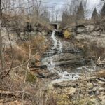
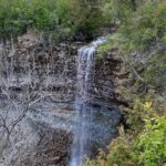
Description Take Rockway ST to the end. Hike back to where it meets Lower Falls Side Trail (km 47.9). Take Main Trail until it meets Lower Falls Side Trail. Take Lower Falls Side Trail until it meets main trail again then continue up Midway Side Trail until it meets Main trail again. Take Main Trail up the hill until it meets Staff Ave ST. Take Staff Ave ST out and back. Then take Louth Side Trail until it meets Main Trail (km 51.2). Turn right and follow Main trail back to Rockway. Photos required towards side trail badge are: 1) Upper Rockway Falls 2) Lower Rockway Falls 3) Moss covered boulders on Louth ST 4) Lower Louth Falls. Must complete all 20 side trails to earn the Side Trails badge.
Description Easy hikes are short hikes (<3 KM) that are generally flat with little elevation change and mostly clear of tree roots and rocks. The pace is slow. Hikes are adjusted according to weather conditions. Footwear with good tread and ankle support are recommended. Hiking poles are recommended, but not required. Bring a small backpack to carry water and light snacks.
We will walk from the parking lot to Horseshoe Lake Trail. Our first stop is pretty Horseshoe Lake. Then, we continue through the mixed forest to the Georgian Bay shoreline. We will stop here for a nutrition break. Then, retrace our steps to Head of the Trails.
Pace: Medium – 3 to 4 km/hour Terrain: Moderate – some hills and/or some poor footing Distance: 10 – 13 km depending on trail conditions
Description From roadside parking on Twiss Rd. we will first hike south through the Yaremko Ridley park as far as Derry Rd. and return. We will then hike the Crawford Forestry Tract to Guelph Line and return. Depending on trail , weather conditions, and time, we can hike into Crawford Lake, hike the boardwalk around the Lake and return. Distance – 10 km; adding in hiking into Crawford Lake – 13 km.
Bring water, snacks/lunch, poles(optional), icers recommended! Dress for the weather conditions.
Carpooling if possible is recommended as there is limited parking on Twiss Rd. Consider wearing a mask if carpooling.
Pace: Brisk Terrain: Strenuous Length of Hike: 12km
Description The Pacific Slope Trail follows the main Bruce Trail. This hike will be an in and out hike of ups and downs with a side step onto the Stew Hilts Side Trail.
Please be prepared with icer’s and/or snowshoes depending on conditions.
Bring snack and water. Please no dogs.
COVID-19 Precautions Before, During and After your Hike
Each hiker joining a Bruce Trail Club organized hike must perform a self-screening check before hiking. Find Ontario’s self-assessment tool here: https://covid-19.ontario.ca/self-assessment/
If you are experiencing COVID-19 symptoms, stay home.
Personal Protective Equipment:
Hikers may choose to wear masks
Transportation
It is the Bruce Trail Conservancy’s current policy that car shuttles are allowed. It is at the discrepancy of individual hike leaders to make that decision.
Other Guidelines
Arrive 15 minutes before the start of the hike.
Wear sturdy footwear and appropriate attire for the weather and the terrain. Hiking poles are a good idea in any season, especially if the terrain is rocky or slippery. In winter, snowshoes or icers/crampons are needed when conditions dictate. Wearing appropriate clothing and footwear prevents injuries and shows consideration for a safe and positive group hiking experience.
Always carry I.D. and your health card.
Bring sufficient water and snacks (or lunch if indicated). A minimum of 1L of water is recommended on all hikes, and 3L is recommended for long, challenging hikes in the heat of the summer.
Bring sunscreen and insect repellent (for spring and summer hikes).
Hosting Club: Toronto Category: Car Hike Location (Google Maps): We meet at the Pear Tree parking (Map 12, 11.4KM, Ed. 30) on 15 Side Road 200 metres South-West of Halton Road 25.
Pace: Brisk, Fast Terrain: Rocky, Variable Distance: 20 KM
Description We will carpool to the parking lot opposite the Limehouse Public School. We will be hiking the Main Trail and the Side Trails (ST) in Speyside, Toronto Section. We hike to where the trail comes out on 5th Line. We will walk back taking in the Ridge ST and the Todd Bard ST. We continue on the Main Trail also hiking on the Vandelick ST and the Cliff Hatch ST to return to the Pear Tree parking. It is a good idea to pack your icers. Bring 1.5 – 2 liters of water and your lunch. Please dress for the weather.
Pace: Medium – 3 to 4 km/hr Terrain: Dependent on Conditions, Easy – Mostly flat and usually good footing, Moderate – Some hills and/or some poor footing Distance: About 9km
Description Bruce trail from Sheppard Quarry under hwy 6 to RBG Berry Tract loop and back.
Please bring water. Poles are recommended.
If you need to contact me on the day of the hike text me at 905-399-3601.
Hosting Club: Blue Mountains Category: Register on-line or sign-in morning of hike Location (Google Maps): Hike meets in the parking lot behind Tim Hortons on First St. in Collingwood.
Pace: Medium – 3 to 4 km/hr Terrain: Moderate – Some hills and/or some poor footing Distance: 8.5km
Description We will start at km 27.9 on the 10th Line for an in/out hike past Metcalfe Rock to km 23.8 and then return. Enjoy the lovely views, a magical time in Kolapore! Bring water and a snack.
Hosting Club: Sydenham Category: An evening walk. Location (Google Maps): Meet in the municipal parking lot by the river on the west side of 1st Ave. E between 7th St. E and 8th St. E in Owen Sound.
Pace: Medium: 3 to 4 km/h Terrain: There might be icy and slippery sections.
Description The hike WILL leave at 7:00 pm – no need to arrive early. This evening we will take in the Owen Sound Festival of Northern lights on both sides of the Sydenham River and at Harrison Park. Please bring icers if conditions are icy. For further information call Harriet Nixon at 519-373-6598 or harrietnixon@bmts.com
You are signing up for the following dates and times: 2022-12-08 at 08:00 2022-12-09 at 08:00 2022-12-12 at 08:00 2022-12-13 at 08:00 2022-12-14 at 08:00 2022-12-15 at 08:00
Pace: Brisk – 4 to 5 km/hr Terrain: Dependent on Conditions, Slippery and Steep Sections, Strenuous – Hilly with steep climbs and some poor footing Distance: 18 – 22km /day
Description This is a special series of 6 hikes to complete the Iroquoia section of the Bruce Trail. There will be a new accomplishment badge, included in the registration fee – which is currently being designed and will be mailed to hikers who complete the series once it is available. (It is unfortunately, unlikely to be available by the time of the sixth hike)
For this inaugural E2E in 6, we will be following the main trail southbound eventually finishing in Grimsby. Please note that you are signing up for the entire series of six hikes. The Iroquoia in 6 series is geared to experienced long distance hikers with the expectation of a 3.5 to 5.0 km/ hr. pace maintained over an 18 to 22 km day. No dropout points have been established and therefore hikers who must drop out, will be responsible for their own transportation.
Hikers will be expected to to be wearing proper hiking boots and layered clothing with the expectation of cool and possible wet weather conditions. Sufficient food and water for a full day of hiking is required and hiking poles, crampons and wet weather gear are recommended. A 20 minute on-trail lunch break will be scheduled.
The fee goes towards supporting the Iroquoia Bruce Trail Club, which in turn supports the mission of the Bruce Trail Conservancy, which is: “Preserving a ribbon of wilderness, for everyone, forever.”
For the time being, registration for the Iroquoia E2E-in-Six will be limited to members of the Bruce Trail Conservancy. Hikers can belong to any section.
A maximum of 1 (of the 6) hikes can be self-completed as a result of scheduling challenges, but it is intended that this badge be earned while hiking as part of a group led by a certified hike leader.
Please note there are no refunds!
This particular set of 10 hikes is intended to be BRISK. Please be honest about your degree of physical fitness prior to registration.
TRANSPORTATION
This series will be through hikes and will require car shuttling, you must be willing to drive or to be a passenger. Some parking locations require paid parking, and hikes that enter Halton Conservation Areas will require reservations. The fee for the E2E-in-Six does not cover any parking/entry fees for hikers who are not members of the Halton CA and/or Hamilton CA. If the group has enough hikers who are members of a CA, those will be the cars chosen to park in those areas so as to minimize costs. At least one hike starts at one CA and ends at another, so parking fees are unavoidable for non-CA members.
From Jordan Hollow Hike the main trail to Upper and Lower Balls Falls, Moyer Road or Louth and Return. You must register for each hike. Dress for the weatherBring Poles, snack a drink and ices
Description Moonlight Nike Hike – Take in the magic of the rising moon over the Lake Ontario and the Niagara River. This hike includes a stop to connect with your senses – sights, sounds, smells and the rhythm of your breath. We will also walk through the streets of Historic Old Town to enjoy the holiday lights. Bring a night light and dress for weather. Counts towards your night hike badge (5 night hikes) and winter badge (15 hikes between December 21st and March 20th).
Description Each Friday we will explore different neighbourhoods, trails and parkland throughout Historic Niagara-on-the-Lake.
Moderate pace with some weeks entirely on sidewalks and roads while others may include a mix of trails and paved pathways. Great way to build up endurance for longer more strenuous hikes.
Prepare for cooler windy conditions on open parkland and along Lake Ontario and Niagara River trails.
Plan to stay for conversation and a warm cup of coffee or tea at Sweets & Swirls, Community Centre, Niagara Stone Road, NOTL2020
Location (Google Maps): Meet on the shoulder, on the south side, turn cars to face east, at the end of North St. in Eugenia. (North St. is directly north of The Top O’ The Rock store.) km 58.3, Map 26, Edition 30.
Pace: Medium Terrain: Some steep sections Length of Hike: Approx. 6 km
Description We’ll be hiking along the escarpment through forest to the Beaver Valley landmark “The Penstocks” and then returning to our cars. Some great views to be had! Please bring snowshoes and icers/crampons and we’ll decide on the day which we need. COVID-19 Precautions Before, During and After your Hike
Each hiker joining a Bruce Trail Club organized hike must perform a self-screening check before hiking. Find Ontario’s self-assessment tool here: https://covid-19.ontario.ca/self-assessment/ If you are experiencing COVID-19 symptoms, stay home. Personal Protective Equipment: Hikers may choose to wear masks
Transportation
It is the Bruce Trail Conservancy’s current policy that car shuttles are allowed. It is at the discrepancy of individual hike leaders to make that decision.
Other Guidelines
Arrive 15 minutes before the start of the hike. Wear sturdy footwear and appropriate attire for the weather and the terrain. Hiking poles are a good idea in any season, especially if the terrain is rocky or slippery. In winter, snowshoes or icers/crampons are needed when conditions dictate. Wearing appropriate clothing and footwear prevents injuries and shows consideration for a safe and positive group hiking experience. Always carry I.D. and your health card. Bring sufficient water and snacks (or lunch if indicated). A minimum of 1L of water is recommended on all hikes, and 3L is recommended for long, challenging hikes in the heat of the summer. Bring sunscreen and insect repellent (for spring and summer hikes). Bring your own first aid kit. Please leave dogs at home.
Hosting Club: Niagara Category: Car Pool Location (Google Maps): 87.3 to 68.8 1826 Snake Road. Roadside Parking N43.317174 W79.892363 Car Pool to West side of Walkers Line Across from Cemetery. 87.3 N43.419107 W79.861377 Paid Parking
Pace: Brisk – 4 to 5 km/hour Terrain: Moderate – some hills and/or some poor footing Distance: 16.6 km
Description This is one for the badge hunters. We’ll not only complete 12.3 km of the Bruce Trail, we’ll also complete all following side trails along the way as there-and-backs: Mohawk, Red Hill, Kingsview Dr., Paramount Park, Glover Mountain Rd., New Mountain Rd, Veever’s Park, Oakridge Drive, Millen Road, and MacDui Drive which will count towards the Iroquoia Side Trail Challenge badge.
We will meet at the street parking on MacDui Drive, then shuttle to the Mohawk 4 Ice Centre on Mountain Brow Blvd. From there, we will complete the Mohawk Side Trail, then hike east along the Bruce Trail through King’s Forest, Felker’s Conservation Area, Devil’s Punch Bowl, and returning to MacDui Dr. Side Trail back to our cars. We will be in the forest for the majority of the hike.
Bring water, snacks, and clothing layers. Poles optional. Please arrive at 8:15 am as we will leave promptly at 8:30 am.
Questions? Contact Hike leader – Freddy Wang – fwang175@gmail.com. 416-788-1567.
Please check email before leaving home. Hike may be cancelled due to weather. Please contact hike leader if you need to cancel last minute. Thank you.
Description We will hike the main trail, as well as a few side trails above and below the escarpment. Please bring hiking poles and icers, if necessary.
Hosting Club: Sydenham Category: General Hike Location (Google Maps): Meet in the north-east corner of the parking lot at Home Depot on Highway 26 on the east side of Owen Sound.
Pace: Medium: 3 to 4 km/h Terrain: Moderate: Some hills and/or poor footing, There might be icy and slippery sections. Distance: 6.5 kms
Description We will explore Bognor Marsh and hope to keep our feet dry if the ground is frozen. We take the main trail around the marsh and continue north until we meet the Bognor Marsh Side Trail. We return via the side trail to the parking lot on the main trail. Depending upon the conditions, icers or snowshoes may be needed. Hiking poles are helpful. (Map 29).
If you wish to meet at Bognor Marsh, please contact the hike leader.
Hosting Club: Blue Mountains Category: Register on-line or sign-in morning of hike Location (Google Maps): Hike meets in the parking lot behind Tim Hortons on First St. in Collingwood.
Pace: Leisurely – 3 km/hr. or less Terrain: Easy – Mostly flat and usually good footing, Moderate – Some hills and/or some poor footing Distance: 5km
Description We will drive via Grey Rd 119 to the end of the 6th Line in the Beaver Valley section. We will hike along the white blazed trail to km 11.3 where it joins up with the Margaret Paull Side Trail. We will follow the side trail back to the white blazed trail, then return to the cars. Bring water and a snack. Map 24 Ed. 30
Pace: Leisurely Terrain: Flat, Other (Refer to Description) Distance: 9 km
Description
Join us for a leisurely walk on The Toronto Islands from Ward Island to the Gibraltar Point Lighthouse, returning via the paths and trails along the northern side with great views of the city at night.
Please bring a headlamp or flashlight. Icers are strongly recommended but keep an eye on the weather forecast. The lake side of the island is generally breezy so dress in layers. Bring a litre of water and possibly snacks.
After the walk we’ll head to a pub near the ferry terminal for refreshments and seasonal cheer.
We will take the Ward Island Ferry scheduled for 4 pm, please arrive at the Jack Layton Terminal by 3:45.
Our aim will be to catch the 6:45 return ferry from Ward Island so we can be at the Fox on Bay Pub by about 7:15. Please email Tom at tjswales@gmail.com if you want to join us at the pub so we can provide them with an accurate count.
Hosting Club: Iroquoia Category: General Hike Location (Google Maps): Ancaster Little League Park – 286 Jerseyville Rd W Ancaster (across from the Ancaster Lions Outdoor Pool)
Pace: Medium – 3 to 4 km/hr Terrain: Strenuous – Hilly with steep climbs and some poor footing Distance: Approx. 10k
Description We will follow the Spring Valley Trail, Martins Road, Headwaters Trail etc. in the western part of the Dundas Valley. Bring water and a snack (poles would also be useful).
Location (Google Maps): Cape Hurd Alvar Bay Nature Reserve – located at 745 Cape Hurd Road about 20 minutes south of Tobermory. Follow Cape Hurd Road west, past MacArthur Road. After the curve on the road, travel about 1 km. Cape Hurd Alvar Bay Nature Reserve is located on the west side of the road. Roadside parking.
Hike Leader(s): Marg Glendon
Pace: Leisurely Terrain: Easy Distance: ~2 km
Description Easy hikes are short hikes (<3 KM) that are generally flat with little elevation change and mostly clear of tree roots and rocks. Hikes are adjusted according to weather conditions. Footwear with good tread and ankle support are recommended. Hiking poles are recommended, but not required. Bring a small backpack to carry water and light snacks.
We will begin our hike at the roadside and walk along the Cape Hurd Reserves Nature Trail to the shoreline. The shoreline is rocky, explore the shoreline at your comfort level. The Cape Hurd Alvar Nature Reserve is home to rare species such as the Massasauga Rattlesnake, Little Brown Myotis Bat and the Eastern Wood-Pewee. We will have a nutrition break at the shoreline and retrace our steps to the beginning of our hiie.
Learn more about Cape Hurd Alvar Nature Reserve here: https://escarpment.ca/see-our-reserves/bruce-county-and-huron-shore/cape-hurd-alvar-bay
Description Get your cameras ready for the Annual Winter Festival of Lights hike. Get into a festive mood with a walk around the Falls for this annual event. Stay afterwards for hot apple cider and festive treats. Feel free to share your favourite treats.
Hosting Club: Caledon Hills Category: Car Hike Location (Google Maps): Vic Johnston Community Centre – Church St., Streetsville (Park in the lower lot near ball diamond). From Hwy 401 come south on Mississauga Rd. Pass Argentia Rd. and, at the next lights, turn left to stay on Mississauga Rd. Follow 3 km into Streetsville (where Mississauga Rd. becomes Queen St.) and turn left on Church St. OR, From QEW or Hwy 403 come north on Erin Mills Pkwy, then – just south of Erin Mills Town Centre Mall – turn right on Eglinton, then left at lights on to Mississauga Rd. Follow for 2 km to right turn at Church St. If you get lost phone Peter’s cell 905-301-4091
Hike Leader(s): Peter Leeney Date: November 16, 2021 GPS Location: 43.5800, -79.70878
Pace: Brisk Terrain: Moderate, Some steep sections Length of Hike: 8.5km
Description This is an in and out hike that will take us up along the top of the ski hill and into Loree forest. It will start off fairly easy to get our legs warmed up then some steep climbs to the top of Loree. We will take a much deserved break before retracing our step back to our cars.
Please be prepared with icer’s and/or snowshoes (depending on conditions we may shorten hike)
Bring snack and water. Please no dogs.
COVID-19 Precautions Before, During and After your Hike
Each hiker joining a Bruce Trail Club organized hike must perform a self-screening check before hiking. Find Ontario’s self-assessment tool here: https://covid-19.ontario.ca/self-assessment/
If you are experiencing COVID-19 symptoms, stay home.
Personal Protective Equipment:
Hikers may choose to wear masks
Transportation
It is the Bruce Trail Conservancy’s current policy that car shuttles are allowed. It is at the discrepancy of individual hike leaders to make that decision.
Other Guidelines
Arrive 15 minutes before the start of the hike.
Wear sturdy footwear and appropriate attire for the weather and the terrain. Hiking poles are a good idea in any season, especially if the terrain is rocky or slippery. In winter, snowshoes or icers/crampons are needed when conditions dictate. Wearing appropriate clothing and footwear prevents injuries and shows consideration for a safe and positive group hiking experience.
Always carry I.D. and your health card.
Bring sufficient water and snacks (or lunch if indicated). A minimum of 1L of water is recommended on all hikes, and 3L is recommended for long, challenging hikes in the heat of the summer.
Bring sunscreen and insect repellent (for spring and summer hikes).
Hosting Club: Blue Mountains Category: Register on-line or sign-in morning of hike Location (Google Maps): Hike meets in the parking lot behind Tim Hortons on First St. in Collingwood.
Pace: Medium – 3 to 4 km/hr Terrain: Moderate – Some hills and/or some poor footing Distance: 10km
Description Hike starts at Km 11.9-km 21.9 (10km) We will park the cars at km 21.9 and car shuttle to km 11.9 to begin the hike. Drumlins, spoon-shaped mounds of glacial sand and gravel, can be seen to the right of the trail (snow permitting). The trail follows several rocky crevices and passes through forests and fields. It meets an old logging road, which it follows across a field and through some wet areas and enters a mature cedar forest with Escarpment cliffs. Bring a snack or lunch and water. Map 22 Ed. 30
Hosting Club: Sydenham Category: General Hike Location (Google Maps): The Galaxy Theatre parking lot. Meet in the parking lot at the tall “Galaxy Centre” sign next to the traffic lights. 1020 10th St. W., Owen Sound
Pace: Medium: 3 to 4 km/h Terrain: Moderate: Some hills and/or poor footing, There might be icy and slippery sections. Distance: 5.5 kms
Description We will hike in on the Glen Side Trail to the main trail, then take the Ron Savage Trail to loop around to the main trail. We follow the main trail to the side trail back to the parking area. Map 33. Depending upon the conditions, icers or snowshoes may be needed. Poles can also be helpful.
Because parking at the Glen Sude Trail is very limited, carpooling from Owen Sound is recommended. Please contact the leader if you do not wish to carpool.
Hosting Club: Iroquoia Category: Good Companions Location (Google Maps): Burlington Public Library, Central Branch, off New Street. Parking lot directly behind the library.
Pace: Medium – 3 to 4 km/hr Terrain: Easy – Mostly flat and usually good footing Distance: 8 km
Description Meeting at 9:15 am for a 9:30 am start, in the parking lot directly behind the Central Branch, Burlington Public Library. An urban hike. We will take the footpath towards the lake front, through Spencer Park and along the lake towards the canal lift bridge. The temperature and weather will determine how far we will go as winds from the lake can be cold and strong. Bring fluids and a snack.
From Jordan Hollow Hike the main trail to Upper and Lower Balls Falls, Moyer Road or Louth and Return. You must register for each hike. Dress for the weatherBring Poles, snack a drink and ices
Pace: Leisurely – 3km/hr or less Terrain: Moderate – Some hills and/or some poor footing Distance: Approx. 9 km.
Description Join us for a pleasant circuit of the Rattlesnake Point and Nassagaweya trails. Using a combination of blue and white Bruce Trail and Conservation Area trails we will hike north and descend down into Nassagaweya Canyon and then south to ascend up out of the canyon and return to our start point. We should get good views across the canyon towards Crawford Lake. Please meet in the lower parking lot of Rattlesnake Point CA. If it is closed we will meet in the upper parking lot. Meet at 9:45 am. for a 10:00 am. start. Bring water, a snack and icers. Poles will be useful. You must make a reservation with Halton Conservation Authority.
Pace: Medium Terrain: Moderate Length of Hike: 9 kms
Description Kimberley Side Trail is one of the trails within the large Kimberley Forest. We will begin at the base of the Beaver Valley Ski Club and then take the snowshoeing trail upwards, meeting the Bruce Trail. We will travel as far as Bill’s Creek and then return. Be prepared for an upward, but gradual climb. We’ll take a few breaks en route. Please bring snowshoes and icers and we’ll decide on the day which is more appropriate. If there is heavy snow, we may turn back before reaching Bill’s Creek.
Description Each Friday we will explore different neighbourhoods, trails and parkland throughout Historic Niagara-on-the-Lake.
Moderate pace with some weeks entirely on sidewalks and roads while others may include a mix of trails and paved pathways. Great way to build up endurance for longer more strenuous hikes.
Prepare for cooler windy conditions on open parkland and along Lake Ontario and Niagara River trails.
Plan to stay for conversation and a warm cup of coffee or tea at Sweets & Swirls, Community Centre, Niagara Stone Road, NOTL
Pace: Medium – 3 to 4 km/hr Terrain: Moderate – Some hills and/or some poor footing, Slippery Sections Likely Distance: 14 km
Description Meet at Crawford Lake Conservation Area parking area nearest to the gatehouse. Conservation Authority reservation fee system is in effect. Make two consecutive Crawford Lake CA reservations beginning at 9:00 one week before the hike.
We will take the Crawford Lake Side Trial to the Main Trail and hike past the lookout and then down into the Nassagaweya Canyon and up to the top of the Rattlesnake Point CA ridge. We will return to our cars via blue and white trails. This hike includes steep inclines in and out of the Nassagaweya Canyon. Ice and snow could make the trail treacherous.
Dress appropriately for the weather and for icy or snow-covered trails. Icers/micro spikes or snowshoes may be required. Bring food and water, hiking boots, cold weather outerwear, personal first aid kit. No dogs please.
Direct inquiries to Victoria at victoriaahb@yahoo.ca at least 12 hours prior to the hike. Please arrive 15 minutes before the hike start time of 9:30 AM. Register using the hiking schedule. Cancellations the morning of the hike please call 905-257-6815.
Description Meeting point is at the parking lot next to the Visitor Centre. Today we will walk around Crawford Lake, a rare example of a meromictic lake, enjoying views and a different outdoor feeling the wooded area gives when the leaves are off the trees and are dormant; essentially they sleep over the winter. On our way to the Nassagaweya Canyon with great views and looping back to the Longhouse Village is well worth a visit. No dogs. Hiking boots, snacks, water and be prepared for the weather forecast of the day.
Entry fee to the park is $9.75 and registration is required – please make your reservation at https://www.conservatio
Hosting Club: Niagara Category: Car Pool Location (Google Maps): 68.8 to 50.6 Gate house Museum . Enter from 621 Sulphur Springs Road. N43.236833 W79.998578 Car Pool to 1826 Snake Road. Roadside Parking N43.317174 W79.892363 Paid Parking
Hosting Club: Niagara Category: Loop Location (Google Maps): Beginning at the Short Hills Provincial Park parking lot on Pelham Rd. Map 3 – north of km 40.9
Description This hike features gently rolling terrain, a majestic Carolinian forest, Terrace Falls and numerous streams. This section of the Bruce Trail is twinned with a section of the Rim of Africa Trail in South Africa. During this hike information about the BTC’s International Friendships Trails will be shared.
Hosting Club: Iroquoia Category: General Hike Location (Google Maps): Limehouse Conservation Area parking lot at the baseball diamonds. Just southwest of km 20.4 on BTC Map 12 (30th Ed.).
Pace: Medium – 3 to 4 km/hr Terrain: Moderate – Some hills and/or some poor footing Distance: 18 km
Description Take a break from the Holiday craziness with a 18km stroll taking in a series of loops that will include the Hole in the Wall, the Black Creek Side Trail, the 17 Sideroad Side Trail, part of the Vanderleck Side Trail, the Canada Goose Side Trail and the Main Trail connecting them all. Please bring lunch, warm drink, water, a snack for elevensies, a smile and an appreciation of nature.
Pace: Medium – 3 to 4 km/hr Terrain: Strenuous – Hilly with steep climbs and some poor footing Distance: 8km
Description A hike to prepare you for the next Olympics! Follow in the footsteps of Olympian Clara Hughes as we walk along the Bruce Trail to the top of Sydenham Hill. We’ll continue on to take in the view of Boer’s Falls and then return along the same route.
There is a steep climb / descent along the Sydenham Hill and some narrow, single file sections to be careful of.
Hosting Club: Blue Mountains Category: Register on-line or sign-in morning of hike Location (Google Maps): Hike meets in the parking lot behind Tim Hortons on First St. in Collingwood.
Pace: Medium – 3 to 4 km/hr Terrain: Moderate – Some hills and/or some poor footing Distance: 7km
Description We will park at km 10.6 on 6/7 Sideroad Nottawasaga. This is a lovely snowshoe hike with rolling hills, pretty woods, and fields. We head to km 17.2. Bring a snack or lunch and water. *The 180 km Transcarioca Trail crosses Rio de Janeiro from Barra de Guaratiba to Morro da Urca, at the foot of the Sugar Loaf Mountain. Map 22 Edition 30
Hosting Club: Sydenham Category: Snowshoe Hike Location (Google Maps): Roadside parking along St. Vincent-Sydenham Townline where the road turns left, at km 55.2 (Map 30) or 9:30 at HD in Owen Sound to carpool
Pace: Leisurely: 3 km/h or less Terrain: Moderate: Some hills and/or poor footing Distance: 4.5 km
Description We start from km 55.2 to follow main trail through forest and along escarpment edge and return on the side trail through mixed hardwood forest.
Description Join us for a morning hike north on the Humber Trail to Dundas Street and eastbound on the Black Creek and Lavender Creek Trail to the Junction Craft Brewery in the rennovated “Destructor” Incinerator building. Light snacks available for purchase, a variety of rotating non-alcoholic beverages are available.
Hosting Club: Toronto Category: Urban Walk Location (Google Maps): Meet at the Toronto Public Library, Beaches Branch, 2161 Queen Street East, Toronto, M4L 1J
Meet at the Toronto Public Library, Beaches Branch. We will walk the boardwalk and easy pathways that wind along the variety of beaches from Silver Birch Avenue to Ashbridges Bay Park. It will be an out and back route, with lots of views into Lake Ontario, you will see many points of interest, parks, Kew gardens, including the historic Leuty Lifesaving Station and the historic architecture of the Ashbridges Bay Wastewater Treatment Plant, the R.C. Harris Filtration Plant. I’ve had frequent visits to this area as Greg, my late husband, grew up in the beach with many fond memories. A pleasing area that offers a little something for everyone!
Description Join us for a hike through beautiful Louth Conservation Area – we will walk the newly created, award winning side trails to see both the upper & lower falls.
Terrain can be challenging with lots of beautiful rocks & some hills.
Meet at the Louth Conservation Area parking lot on Staff Avenue.
Pace: Medium Terrain: Difficult, Easy, Moderate Distance: 12 Approx.
Description
December 18, 2022 – This hike is through the mature forest of Hope Bay Forest Provincial Nature Reserve We will hike the Hopeness, Jack Poste and Don Irish Side Trails and loop back on the main trail for some gorgeous lookouts overlooking the Hope Bay.
Dress according to weather in layers. Bring water, lunch and wear appropriate footwear for rugged terrain.
Time commitment is approximately 4-5hrs.
Please arrive a few minutes before our starting time of 9:30am
Hosting Club: Toronto Category: Urban Walk Location (Google Maps): Meet at Kipling Subway Station for 10 am, at the west end of bus platforms by the washrooms to catch the #111, The East Mall at 10:02. It is a 15-minute bus ride that will take us to the start of the hike at The East Mall & Eglinton Avenue West. If coming directly to the hike by car there is parking by trail access point at the end of West Deane Valley Road (curbside parking). West Deane Valley Road runs east from the East Mall. If you are exercising this option, please arrive by 10:15, walk down along the trail to the bridge and wait for the group to arrive. It is necessary to inform the hike leaders ahead of time or you may miss us.
Pace: Moderate Terrain: Flat, Variable Distance: 12.5 km
Description In November we lost one of the most dedicated and personable hike leaders our club has ever seen in Wayne Crockett. As well as his impeccable leadership skills and knowledge of Canadian history, Wayne was known for his dry-wit humor. Attempting the Mimico Creek Trail, south of Bloor Street, on an early morning in Spring, during another Covid lockdown, Wayne posted on his Facebook page, “…based on someone once telling me that with a little perseverance, you can find a path along the Mimico Creek from Bloor to the lake shore (about 4 km in a straight line). They lied or I misremembered. I did find some nice stretches of natural path running within a metre or two of the creek but they always dead ended and I had to retrace and do some road walking to find another point of access… Not going to be added to my repertoire, there would be a mutiny for sure.” And commenting on his own picture of some ducks lounging in the creek he wrote, “They were laughing. Ha, this Hooman just walked by here going the other way five minutes ago….” I plan to keep a few of Wayne’s frustrations as part of the hike, with the group not knowing if we are passing through or having to double back. Let the ducks laugh! Little did you know, Wayne, that we would follow you anywhere.
Come join Tom Swales and I as we undertake to hike the Mimico Creek Trail in two parts. Part 2 will go in January 2023. Originally planned as one long hike, upon a second pre-hike we realized that because we are now in winter conditions with packed snow and icy patches that a longer hike will be too exhausting. Also we are waiting for the Berry St. footbridge to reopen so we can hike the preferred route and avoid any unnecessary road walking. Wayne’s prophecy of mutiny may well have come to pass!
Wayne began his hike at Tom Riley Park from Dundas Street and meandered his way to Humber Bay Park and then east along the waterfront trail towards home. We will begin Part 1 much further north from Eglington Avenue, walking on beautiful forest trails on the west side of the creek through West Deane Park as far as past Rathburn Road. Next doubling back on Martin Grove Road we will cross over and pick up the trail on the east side at Ravenscrest Park. Further on there will be a stretch of road walking along Burnhamthorpe Road (not too unpleasant) before we reach Tom Riley Park and then begin to follow Wayne’s route to his first frustration. Reaching the Van Dusen Blvd footbridge we will head in an easterly direction towards Park Lawn Cemetery, leaving south of Van Dusen for Part 2. Wayne loved to come to Park Lawn Cemetery in recent years to sight a group deer that make there home there during the winter months. With any luck we may spot them. Passing through the cemetery we will join up with the Humber River Trail and finish our hike at Old Mill Subway Station.
Dropouts at Bloor St. (at 8.3 km, Islington Subway Station is just steps west of there), Royal York Road (at 9.6 km, #76 Bus takes you to Royal York Station or you can walk up in 15 minutes.
Hosting Club: Iroquoia Category: General Hike Location (Google Maps): MEET at Hamilton Rail Trail -Binkley Road parking lot To find Binkley Road parking lot -Take Governor’s road heading west past the main entrance of DVCA to Binkley Road Turn left onto Binkley road and quick right turn onto Old Highway 99 The parking lot is beside the rail trail entrance on the left
Pace: Medium – 3 to 4 km/hr Terrain: Moderate – Some hills and/or some poor footing Distance: Approximately 12 kms
Description Winter hike on trails leading into Dundas Valley Conservation area. We will start on the Hamilton Rail Trail from the Binkley Road parking lot and follow that to Gravel Pit Road and onto the Headwaters trail We will hike to the Lookout trail, have a break/lunch and head back via the Reforestation Trail, Mineral Spring Roads and back onto the rail trail to our parked cars. Suitable trail for dogs as long as leashed and friendly. Please have water to hike and wear suitable clothing for the weather- Bring a snack/lunch, hiking boots, poles and ICERS -Dundas Valley trails can be quite icy depending on the weather
To find Binkley Road parking lot -Take Governor’s road heading west past the main entrance of DVCA to Binkley Road Turn left onto Binkley road and quick right turn onto Old Highway 99The parking lot is beside the rail trail entrance on the left
Any questions or concerns, please email me at cathiekygreen@gmail.com or text 416-931-2095
Description Meet at the entrance parking lot at 1 Leslie St. We will walk to the end of the spit and back using some of the various side trails. A unique place to experience nature, the spit has been made from the rubble from an ever growing Toronto. Excellent views of Toronto and Lake Ontario. No dogs. Bring snack/lunch water. Dropouts along the way.
Hosting Club: Sydenham Category: General Hike Location (Google Maps): Tourism Office parking lot at 717875 Hwy. 6 just north of the traffic lights at Springmount, west of km 104.4 (Map 32)
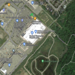
Hosting Club: Niagara, Iroquoia Category: General Hike Location (Google Maps): We are meeting at the first parking area but there are three parking areas for this hike altogether, as follows: 1. Mountainview Conservation Area – West side of Mountainview Rd between McLeod St and Locust Lane 43.157888, -79.497415 2. Jordan Hollow King St (Hwy 81) across from Boo’s Restaurant 3039 King St Jordan Station 43.142022, -79.372672 3. Jordan Main St Parking lot across from Jordan Art Gallery (43.1491405, -79.3698233)
Pace: Brisk – 4 to 5 km/hr, Medium – 3 to 4 km/hr Terrain: Dependent on Conditions, Moderate – Some hills and/or some poor footing, Strenuous – Hilly with steep climbs and some poor footing Distance: Approx 15km in total
Description This is a 3-part hike with 3 parking locations. Please carpool if you are able.
Part hike, part history, part viticulture, this outing explores the area referred to as the Niagara Bench.
Please bring enough snacks, water and your icers in case of icy trail conditions. Requirements for the badge are found here:http://niagarabrucetrail.club/wp/wp-content/uploads/2022/12/Niagara-Benchlands-Badge.pdf Badges will be available following the third hike. M$10/NM$15
An optional stop following the third hike for coffee and a treat.
You are signing up for the following dates: 2022-12-19, 2022-12-22, 2022-12-23, 2022-12-28, 2022-12-30, 2023-01-02, 2023-01-04, 2023-01-06, 2023-01-09, 2023-01-11
Pace: Brisk – 4 to 5 km/hr Terrain: Moderate – Some hills and/or some poor footing Distance: 10-16 kms per hike
Description This is a special series of 10 hikes with a new accomplishment badge. The registration fee includes the new special event badge, however, it will be up to a hiker who has not earned the badge in time to receive it on the last hike to arrange to pick up the badge or have it posted to them.
The fee goes towards supporting the Iroquoia Bruce Trail Club, which in turn supports the mission of the Bruce Trail Conservancy, which is: “Preserving a ribbon of wilderness, for everyone, forever.”
For the time being, registration for the Iroquoia E2E-in-Ten will be limited to members of the Bruce Trail Conservancy. Hikers can belong to any section.
A maximum of 3 (of the 10) hikes can be self-completed as a result of scheduling challenges, but it is intended that this badge be earned while hiking as part of a group led by a certified hike leader.
Please note there are no refunds!
This particular set of 10 hikes is intended to be BRISK (4-5km/h) where conditions safely allow. Please be honest about your degree of physical fitness prior to registration.
TRANSPORTATION
This series will be through hikes and will require car shuttling, you must be willing to drive or to be a passenger. Some parking locations require paid parking, and hikes that enter Halton Conservation Areas will require reservations. The fee for the E2E-in-Ten does not cover any parking/entry fees for hikers who are not members of the Halton CA and/or Hamilton CA. If the group has enough hikers who are members of a CA, those will be the cars chosen to park in those areas so as to minimize costs. At least one hike starts at one CA and ends at another, so parking fees are unavoidable for non-CA members.
Description This hike follows the east bank of Twelve Mile Creek to downtown then back and continues on the side trail towards Brock University until it meets the Main Trail and then back. Counts towards the NBTC Side Trail badge. Required photos include: Graffiti under the bridges, Twelve Mile Creek, Pedestrian bridge over Hwy 406.
Description Easy hikes are short hikes (<3 KM) that are generally flat with little elevation change and mostly clear of tree roots and rocks. Hikes are adjusted according to weather conditions. Footwear with good tread and ankle support are recommended. Hiking poles are recommended, but not required. Bring a small backpack to carry water and light snacks.
Meet at Dunks Bay Parking Lot at the end of Dunks Bay Road in Tobermory. We will car shuttle to the Northern Cairn in Tobermory to start our hike. Wear masks for the car shuttle please. Our hike today will start at the Bruce Trail Northern Cairn located near the Princess Hotel on Bay St. It’s at this very location that Ray Lowes officially opened the Bruce Trail in 1967. The Cairn was designed by Ruth Arnsberger and built by Ivan Lemcke. Learn about the history of the Bruce Trail as we walk along the main trail through the village, past the Visitor’s Centre and finally reaching Dunks Bay. Here, we will take a short rest here to enjoy the peace and quiet of the lovely sandy beach, before returning to the Meeting Place. We will finish our hike here. All hike participants are invited to the Meeting Place to enjoy some festive goodies and hot apple cider.
Hosting Club: Caledon Hills Category: Tuesday Hikers Location (Google Maps): Scotsdale Farm parking lot. From Highway 401 go north on Trafalgar Rd. until it merges with Highway 7, turn left on Highway 7, after about 4 km Trafalgar Rd. will branch-out to the right, take Trafalgar Rd., entrance to Scotsdale Farm is on the right after about 1.5 km. An unpaved road leads to the parking on the left.
Pace: Medium – 3 to 4 km/hour Terrain: Moderate – some hills and/or some poor footing Distance: 13 km
Description Will go on main Bruce Trail and side trails in Scotsdale and Silver Creek Conservation Area, Duff Pit, Reservoir, Trafalgar, Maureen Smith and parts of Bennett Heritage in a loop. Bring water, snack and if prefer a warm drink. Recommend poles, gaiters and icers. Dress according to weather, in layers.
Pace: Brisk, Medium Terrain: Some rocky footing, Some steep sections, Strenuous Length of Hike: 8.5km
Description We will follow the road allowance south before turning in and ascending the Escarpment. Proceeding through a level section of forest and descending across a scree slope, the trail continues across the base of the Escarpment before ascending to the top. Along the top it skirts McCluskey’s Rock and descends a wide valley to reach the Ken Young Side Trail. We will take this side trail to 7B then follow the road back onto the main trail and re-trace our steps back the same way.
Hosting Club: Toronto Category: Car Hike Location (Google Maps): We will meet at km 17.4, east side of the road, where it crosses the trail. GPS coordinates N 43.615163,W 79.975157
Description We will be shutting to Kelso parking, close to Appleby Line and will walk back to the cars, passing by the location of the first blaze on the Bruce Trail. Please note that we need to pay by the hour per person for parking in Kelso. If any hiker has an annual pass, let me know. Pass holders can do the shuttle and the rest of the hikers are expected to pay the driver $2.
Bring 2 litres of water, icers and snowshoes. Hikers are expected to follow all Covid 19 restrictions.
Pace: Leisurely – 3 km/hr. or less Terrain: Easy – Mostly flat and usually good footing Distance: 5km
Description Wear your festive colours! Hike this 204 acre property featuring majestic, mature sugar maple trees and a meandering cold water stream. This lush Niagara Escarpment forest is home to a variety of rare and at-risk species. The sounds of hairy and pileated woodpeckers echo through the trees. We will creatively combine Mingay, Maple Leaf and Trout trails to complete a loop-de-loop. Bring a snack and water.
Hosting Club: Iroquoia Category: Good Companions Location (Google Maps): Meet in the parking lot by the Pavillion at the RBG Nature Center (Arboretum) at 9:45am. https://www.google.com/maps/place/43%C2%B017’06.7%22N+79%C2%B053’59.5%22W/@43.285189,-79.9020436,17z/data=!3m1!4b1!4m5!3m4!1s0x0:0xc8bc6caf3a95cb16!8m2!3d43.285189!4d-79.8998549
Description Each Friday we will explore different neighbourhoods, trails and parkland throughout Historic Niagara-on-the-Lake.
Moderate pace with some weeks entirely on sidewalks and roads while others may include a mix of trails and paved pathways. Great way to build up endurance for longer more strenuous hikes.
Prepare for cooler windy conditions on open parkland and along Lake Ontario and Niagara River trails.
Plan to stay for conversation and a warm cup of coffee or tea at Sweets & Swirls, Community Centre, Niagara Stone Road, NOTL
Description THIS HIKE IS CANCELLED DUE TO THE WINTER STORM WARNING.
Take a break from the busy holiday season: This hike follows the waterfront trail through Rattray Marsh, Jack Darling and Saddington parks ending in Port Credit for lunch at the Archtop Coffee Bar and Market. Dress for the weather: hiking poles and boot icers may be recommended.
If you are taking the GO Train from Union Station, please board the 8:45 am Lakeshore Westbound train to Clarkson GO Station. Please try to sit in the railway car near the middle of the train on the raised platform. I will meet you on the same raised platform as the train pulls into Clarkson GO Station at 9:20 am. You may also drive to Clarkson GO station and park for free on a first come/first served basis. Please meet us at the same location, on the raised platform where the train from Union GO Station will pull in at 9:20 am.
Pace: Medium – 3 to 4 km/hr Terrain: Moderate – Some hills and/or some poor footing Distance: 6KM
Description Dundas Valley Conservation Area is a magnificent outdoor area consisting of over 40km (about 24.85 mi) of trails located minutes from the downtown core of Hamilton. Join us Friday, December 23rd at 11:30 as we explore the Dear Run loop, the Main loop, and the Headwaters trail to the Homestead Trail loop.
This will be a moderately paced hike totaling about 6KM. The hike should finish within 2 hours.
We will meet at the picnic tables at the trail centre
The gatehouse will be closed, entry is free if you have your HCA card or $11 if you do not have a membership. Only credit cards are accepted at the gate.
The trail is gravel or grass with some roots and rocks and some steep hills.
Bring snacks, a warm beverage, and weather-appropriate clothing. Icers may be needed depending on the weather.
Please arrive at 11:15 so we can start promptly at 11:30
If the weather is stormy I will send out an email the morning of the hike letting you know if it’s canceled. If you need to cancel please send an email letting me know.
Hosting Club: Toronto Category: Car Hike Location (Google Maps): 14350 Dufferin Street, King, ON park along Dufferin street or northern part of Fairfield Drive, Gathering in front of trailhead
Hosting Club: Iroquoia Category: General Hike Location (Google Maps): Orchard Community Park parking lot on the north side of Blue Spruce Avenue just east of Sutton Drive in Burlington.
Pace: Medium – 3 to 4 km/hr Terrain: Moderate – Some hills and/or some poor footing Distance: 10 km
Description Enjoy a quiet Christmas Day morning exploring the west side of the Twelve Mile Creek in Bronte Provincial Park as we trundle through woodland and then descend the valley to the creek that William Lyon Mackenzie had to cross in a hurry in the aftermath of the failed 1837 Upper Canada Rebellion. We will see from a distance the massive rock that formed the roof of Devil’s Cave where he hid out trying to escape the noose. Our day will be a lot more peaceful! We will check out Spruce Lane Farm and hopefully some farm animals too. The trail could very well be icy so please bring your icers as well as a snack and a warm drink.
Pace: Medium Terrain: Difficult, Moderate Distance: 12
Description Don your hiking boots and prepare for some breathtaking sights in one of the best sections on the Peninsula. We will meet at Cyprus Lake [P2] to hike the Cyprus Lake, Mar Lake, Horse Lake Trails and the Bruce Trail totalling about 10k. This hike does include some challenging sections; bring lunch and tons of positive energy and don’t forget your camera.
Hikers are responsible for the Parks Parking and Admission fee
Hosting Club: Toronto Category: Urban Walk Location (Google Maps): Meet inside Jack Layton Ferry Terminal, foot of Bay Street. TTC – take any streetcar from Union Station one stop south the Ferry Docks stop and walk south.
Description Avoid the Boxing Day shopping crowds and come hike with the TBTC instead. The Toronto Islands are very peaceful in the Winter Season. We will catch the 2:15 or 2:45 pm ferry to be back in the city by 3:00 pm. Bring a lunch, snacks, water, a hot beverage, and icers if the first snow has fallen. Dress in warm layers appropriate to the weather. Heated washrooms available. Dropout anytime by walking back to the Ward’s Island Ferry Dock. We will hike towards Hanlan’s Point and return to Ward’s Island (the only ferry destination served in the Winter) – approximately 5-6 km each way.
This hike follows along Moody Lake, to Morningstar Mill Side Trail, then to DeCew House and Morningstar Mills and back. A stop at the First Nations Peace Monument will be included, time permitting.
Hosting Club: Niagara, Iroquoia Category: General Hike Location (Google Maps): We are meeting at the first parking area but there are three parking areas for this hike altogether, as follows: 1. Mountainview Conservation Area – West side of Mountainview Rd between McLeod St and Locust Lane 43.157888, -79.497415 2. Jordan Hollow King St (Hwy 81) across from Boo’s Restaurant 3039 King St Jordan Station 43.142022, -79.372672 3. Jordan Main St Parking lot across from Jordan Art Gallery (43.1491405, -79.3698233)
Pace: Brisk – 4 to 5 km/hr Terrain: Dependent on Conditions, Moderate – Some hills and/or some poor footing, Strenuous – Hilly with steep climbs and some poor footing Distance: Approx 15km in total over all 3 hikes.
Description This is a 3-part hike with 3 different parking locations. Please carpool if you are able.
Part hike, part history part viticulture, this outing explores the area known as the Niagara Bench. Please bring enough snacks, water and your icers in case of icy trail conditions.
Requirements for the badge are found here: http://niagarabrucetrail.club/wp/wp-content/uploads/2022/12/Niagara-Benchlands-Badge.pdf
Badges will be available following our third hike. M$10 NM$15
An optional stop following our third hike for coffee and a treat.
Hosting Club: Caledon Hills Category: Tuesday Hikers Location (Google Maps): Meet at Winston Churchill Blvd. intersection with Caledon Trail-way. Driving direction: North on Highway 410, continue north on Highway 10, left on King Street, right on Winston Churchill Blvd; drive 1 kilometre to roadside parking on either side of the road.
Pace: Medium – 3 to 4 km/hour Terrain: Moderate – some hills and/or some poor footing Distance: 13 km
Description Come and join the last Tuesday hike of the year and enjoy wandering through our favourite forest trails. Will hike Terra Cotta Side Trail and the main Bruce Trail. Bring water, snack, a hot drink is recommended. Poles, gaiters and cleats are necessary to steer through the snow, weather depending. Dress in layers. Optional after hike stop at Higher Ground Café. Phone contact for the day of hike: 416-566-0503
Location (Google Maps): Park @113.6k Beaver Valley section (park on south side, east of trail access). Ensure that cars are completely off the paved portion of the road. Map 28 Edition 30
Pace: Brisk Terrain: Moderate, Some rocky footing Length of Hike: 12km
Description This is one of my favourite winter hikes, so I have waited until now in hopes there will be good snow coverage. Sugar maple/hemlock forest, wetlands, open marsh, views of the bay and cedar bush will all be enjoyed in this in and out hike.
Please be prepared with icers’s or snowshoes
Bring water and snack. Please no dogs.
COVID-19 Precautions Before, During and After your Hike
Each hiker joining a Bruce Trail Club organized hike must perform a self-screening check before hiking. Find Ontario’s self-assessment tool here: https://covid-19.ontario.ca/self-assessment/
If you are experiencing COVID-19 symptoms, stay home.
Personal Protective Equipment:
Hikers may choose to wear masks
Transportation
It is the Bruce Trail Conservancy’s current policy that car shuttles are allowed. It is at the discrepancy of individual hike leaders to make that decision.
Other Guidelines
Arrive 15 minutes before the start of the hike.
Wear sturdy footwear and appropriate attire for the weather and the terrain. Hiking poles are a good idea in any season, especially if the terrain is rocky or slippery. In winter, snowshoes or icers/crampons are needed when conditions dictate. Wearing appropriate clothing and footwear prevents injuries and shows consideration for a safe and positive group hiking experience.
Always carry I.D. and your health card.
Bring sufficient water and snacks (or lunch if indicated). A minimum of 1L of water is recommended on all hikes, and 3L is recommended for long, challenging hikes in the heat of the summer.
Bring sunscreen and insect repellent (for spring and summer hikes).
Description We meet at the parking location @ km 42.2 and car shuttle to parking location at km 53.9. The hike starts from km 53.9 to km 42.2 map 18 of BTC Guide.
Please pack snacks, food and water to replenish your energy during the hike.
Dress according to the winter weather conditions, with proper hiking boots. Icers are required if the trail has icy conditions. Hiking poles are recommended for better control and balance while hiking.
Description This is the 6th of a series of 9 hikes to complete the End to End of the Niagara Section. Dress for the weather and bring drink and snack. Make-up hike for those who could not make this hike on December 7th but open to anyone who wants to enjoy this interesting hike of the Niagara section.
From Jordan Hollow Hike the main trail to Upper and Lower Balls Falls, Moyer Road or Louth and Return. You must register for each hike. Dress for the weatherBring Poles, snack a drink and ices
Description We meet at the parking location @ km 16 and car shuttle to parking location at km 2.7. The hike starts from km 2.7 to km 16 map 14 & 15 of the BTC Guide.
Please pack snacks, food and water to replenish your energy during the hike.
Dress according to the winter weather conditions, with proper hiking boots. Icers are required if the trail has icy conditions. Hiking poles are recommended for better control and balance while hiking.
Description Each Friday we will explore different neighbourhoods, trails and parkland throughout Historic Niagara-on-the-Lake.
Moderate pace with some weeks entirely on sidewalks and roads while others may include a mix of trails and paved pathways. Great way to build up endurance for longer more strenuous hikes.
Prepare for cooler windy conditions on open parkland and along Lake Ontario and Niagara River trails.
Plan to stay for conversation and a warm cup of coffee or tea at Sweets & Swirls, Community Centre, Niagara Stone Road, NOTL
Description We will explore Oak Ridges Corridor in Richmond Hill, Hike around Bond lake .
To reach there turn right to Bethesda side road from Bayview Ave. Then drive around 500 meter and park in Oak Ridges trail head parking.
It is winter time please bring your icers, hiking poles, proper closing and shoes and hot drinks,
Please carefully read safety procedures during the hike:
1-Hikers must stay between the leader and the sweep.
2-Hikers must advise the leader or the sweep if they wish to leave the group.
3- Hikers must follow the whistle instructions: 1 blast- stay where you are; 2 blasts come to the leader; 3 blasts – come to the leader quickly.
4-Hike leader may request volunteers to stop at trail intersections, they need to help hikers to the direction the group walk and wait till they see the sweep .
5-Hikers have to make sure they can see the persons behind and in front of them.
Hosting Club: Niagara Category: Car Pool Location (Google Maps): 50.6 to 34.0 Concession St East side of Jolly Cut. N43.243490 79.861486 Car Pool to Gate house Museum . Enter from 621 Sulphur Springs Road. N43.236833 W79.998578 Paid Parking
Description Please meet be by 10:30 am in the parking lot for the plaza on the south east corner of Steeles Ave West and Dufferin St.
We will hike south through Gross Lord Park, south east along a hidden trail (there is one short steep hill that may require poles for some) to Bathurst, past the edge of the Hinder Area to Earl Bales Park where we end the hike at Sheppard Ave West, just east of Bathurst St. for an estimated distance of 9 km. We will take the Sheppard bus to Yonge and Sheppard. The pub stop is The Frog near Sheppard Station for those who wish to join me.
Bring icers, a snack and 2 liters of water. Dress for the cold.
Hosting Club: Toronto Category: Car Hike Location (Google Maps):
Scotsdale Farm main and side trails.
Directions: North on Trafalgar Road past Georgetown to Hwy 7. Northwest of & to Silver Creek. Turn right onto Trafalgar Road. Go north about 1.5 km. The parking area is about 0.5 km from the Trafalgar Rd.
Pace: Leisurely Terrain: Variable Distance: 8-13 km
Description Join your hiking friends for a pre New Years Eve hike at Scotsdale Farm. We will complete a loop of 8 to 13 km depending on trail conditions. Icers are strongly recommended as trail conditions may be marginal.
After the hike those interested are invited to join me for refreshments and to say goodbye to the old year at the Sheppard’s Crook in the of centre of Georgetown.