Pace: Moderate (3-4 km/hr) Terrain: Flat, Level 2 (Intermediate – some hills and uneven surfaces, rocks and roots underfoot), Variable Distance (km): 10-12
Description Let’s roll the hills of the Jefferson Forest this winter! Every weekend, we’ll explore the winter wonderland at this beautiful park. Located in the heart of Richmond Hill, it boasts numerous hiking trails. This 3-hour hike can range from 10 to 12 kilometres, depending on the weather conditions. Remember to bring water, snacks, hiking boots, icers, poles, and your camera. Not recommended for beginners. Park in the free Bethesda parking lot and avoid parking along the road. Dress appropriately for the weather. Difficulty Level: 2 (Moderate).
Please arrive @8:45AM for start of 9:00AM.
This is a joint hike with the Oak Ridges Trail Association (ORTA).
Pace: Medium – 3 to 4 km/hr Terrain: Moderate – Some hills and/or some poor footing Distance: 6.5 kms
Description Meeting in the parking lot behind the Kilbride School at 9:15 am, we will hike along the main trail to Twiss Road and turn around and hike back. There is some technical footing near the Twiss Road end of the trail, but otherwise this is a fairly easy hike. Bring icers for your boots. Hike is dependent on weather conditions.
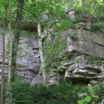
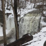
Description From the parking lot, we will hike along the Ice Cave Trail, the Margaret Reed Side Trail and the main Bruce Trail, stopping to explore and discuss the geology of the Niagara Escarpment, the Beamsville Bench wine region and the physiographic and geologic conditions that make it special. After a short in-and-out hike on the Ice Cave Trail, we will slowly begin an incline up the Margaret Reed side trail as we scale the Niagara Escarpment. We will consider the 450+million years of history we are hiking through as we make our way slowly to the top. We will stop along the way to discuss and rest. Once at the top, the terrain on the Bruce Trail is generally flat but footing may be uneven. It may be icy or wet and slippery. Hiking poles will make the ascent easier and give more stability on uneven footing. We will hike to the site of the very first blaze on the Bruce Trail and admire the views of Lake Ontario and the vineyards of Cave Spring and Malivoire wineries. Winter offers the most unobstructed views of this beautiful area. We will return the way we came.
Hikers that are not registered cannot be accommodated on this hike. This hike is for members only.
Hosting Club: Iroquoia Category: Moonlight Hikes Location (Google Maps): We will meet at Dundas Drive Through Park, at 71 Cross St, Dundas. Proceed through the gate and take the road on the right to available parking on the east side of the park. I will have my tailgate up on my dark grey Acura RDX. Please plan to arrive by 6:30 so we can get everyone registered and head out
Pace: Medium – 3 to 4 km/hr Terrain: Slippery and Steep Sections, Strenuous – Hilly with steep climbs and some poor footing Distance: 7.5 km
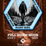
Description The Full Worm Moon hike is the third full moon hike of 2026. We meet at the parking area inside Dundas Drive Through Park (71 Cross St Dundas) on the east side of the park. Please plan to arrive by 6:30 to get everyone registered and on our way.
We will hike out of the park along Alma St and pick up the main trail/Tews Fall Side Trail, climbing the escarpment, hiking along the top to Dundas Peak – there will many views overlooking Dundas and afford us some good views of the Full Worm Moon. A short pause for pics at the Peak and back down along the Glen Ferguson Side Trail/Tews Fall Side Trail and back to the park and our cars.
Be sure to wear layered clothing, bring water, icers and poles if you use them. The ascent might be icy as this is a popular trail to the Dundas Peak.
Since this the third hike in the series, some hikers will qualify for the Iroquoia Full Moon badge – new for 2026! Cost is $10 for BTC Members and $15 for non-members. Badges can be picked up at this hike if you pre-order and pay through Iroquoia Bruce Trail Club Badges – Iroquoia Bruce Trail Club
Members / Click to Purchase Your Badges https://www.zeffy.com/en-CA/ticketing/1de4dba1-aca4-44e2-b0b0-d94f1c826c42
Non-Members / Click to Purchase Your Badges https://www.zeffy.com/en-CA/ticketing/93131d23-cc73-44fe-913d-e4938ee174c6
Pace: Medium – 3 to 4 km/hr Terrain: Dependent on Conditions, Moderate – Some hills and/or some poor footing Distance: 12 km
Description This is a series of 6 hikes to explore various side trails in the Toronto Section of the Bruce Trail. Hikers completing all six hikes will be eligible to obtain the Toronto Side Trail Badge. Each hike requires a separate registration. The hikes in this series will take place on January 12, 26, February 2, 9, 23, and March 2. Hikes will be dependent on weather / travel conditions. All hikes will be undertaken at a medium pace.
This hike, the final one of the series, will explore the Terra Cotta Side Trail as part of a loop around the Terra Cotta Conservation area.
Dress in layers for the weather, wear appropriate hiking footwear, bring icers and hiking poles. Bring plenty of water or other hydration and a snack.
Please arrive at the meeting place by 8:15 am. We will depart promptly at 8:30 am.
If your plans change and you are unable to join the hike, please cancel your reservation in the My Hikes Section of the BTC website.
Hosting Club: Iroquoia Category: General Hike Location (Google Maps): Meet at Erindale Park. The entrance to Erindale Park is 1695 Dundas Street West, Mississauga, just east of Mississauga Road.
Pace: Medium – 3 to 4 km/hr Terrain: Dependent on Conditions Distance: 13 km
Description This is leisurely in-out hike.
We will walk north on the Culham Trail along the Credit River for around 6.5 km to the Barbertown Park near Barbertown Bridge. We will have a snack break there, and return through the same route to our starting point at Erindale Park. Even on the same trail, in the same park, the walk back offers a different view—the light shifts, details emerge, and familiar scenery feels newly revealed.
The terrain is flat with gentle hills but may have some poor footing, muddy or slippery sections during winter condition. Bring hiking poles, icers, plenty of water or other hydration and a snack.
Public washrooms are only available at Erindale Park, but nature stops will be offered during the hike.
Description Hike the main and side trails of Short Hills Provincial Park. Please note that there are some steep hills and rocky sections so you should have some hiking experience before joining this hike. Please bring water, hiking poles and icers, as the trail can be very icy at times.
Location (Google Maps): Parking lot is off Sycamore Drive, East of Bayview , across Starbucks plaza Bus 91 from Finch East station stops at Sycamore station.
Pace: Moderate (3-4 km/hr) Terrain: Hilly, Level 2 (Intermediate – some hills and uneven surfaces, rocks and roots underfoot), Variable Distance (km): 6-7 km
Description We will explore Valleyview and Maple View parks, and walk along German Mill Creak, in return we stop in Huntington park and have snack under beautiful shed.
Although this is considered an “Urban Walk”, you can expect some hills up and down and uneven surfaces with tree roots. Please bring hiking poles, Ice cleats water and snacks.
Hosting Club: Dufferin Hi-Land Category: Tuesday Hike Location (Google Maps): Palgrave Forest and Wildlife Area Parking lot on west side of Hwy 50, south of Finnerty Rd
Pace: Leisurely Terrain: Dependent on Conditions, Easy Distance: 6 Km
Description We will hike through some of the many trails in the Palgrave Forest. Bring snack. Poles and icers recommended . Depending on conditions, snowshoes may be needed.
Hosting Club: Caledon Hills Category: Tuesday Hikers Location (Google Maps): Orchard Park parking lot off Blue Spruce Avenue near Alexander Public School. From QEW westbound take Burloak Drive north, Blue Spruce Avenue is immediately after bend in the road as Burloak Drive becomes Upper Middle Rd.
Pace: Medium – 3 to 4 km/hour Terrain: Moderate – some hills and/or some poor footing Distance: 8-10 km
Description Will hike in Brontë Creek Provincial Park, Brontë Creek Trail, Lookout Ravine Trail, Trillium Trail and other paths along the creek. The trails may be slippery, bring icers, poles are recommended. Bring your choice of drink and snack. Dress warmly, in layers.
Pace: Leisurely (2.0 – 3.0 km/h): A relaxed pace with frequent breaks and a focus on enjoyment. Terrain: Easy: Flat forested sections or lowland trails. Distance: ~3km
Description 🌕Full Moon Hike Series: Part 6 of 7 🌕 Hike along the Shimmering Waters of Georgian Bay (Cape Chin South) 🌕
Join us for hike six of a seven part Full Moon Hike Series
We will take a 3km figure 8 journey along the main Bruce Trail with a fantastic view of Georgian Bay and the Cape Chin Side Trail amongst the trees.
Date: Tuesday, March 3rd
Hike Time: 6:00 pm
Sunset: 6:12 pm
Moonrise: 6:45 pm
Hike length: 3 km Total
Duration: 2 hours
Location: Cape Chin South. Parking at the end of Carter Rd.
Note: If the main Bruce trail is too icy at Cape Chin South we will move the hike to Lindsay Tract Trails.
Full Moon Hiking Badge Info: 1. Hikers must complete 4 out of 7 hikes (if a hike is cancelled registration counts) 2. Hikers will email the treasurer $10.00 to cover the cost of the badge. Email is treasurer@peninsula.brucetrail.org -> In the message section indicate Full Moon Badge -> If you can, take a screenshot of your payment 3. Email Bill Floyd at barriebill@gmail.com indicating: -> The months you attended the full moon hikes (eg, Oct, Dec, Jan, March) -> Confirm that you have sent the e-transfer. If you have a screenshot please attach. -> Include your full address 4. Successful in earning your badge -> If you attend the Apr 1st hike (and the above are completed) the badge will be handed out -> You can also bring cash that evening to receive your badge -> The badge can also be mailed (hence the need for your address)
What to bring:
Illuminate the path with a red light headlamp (if you don’t have one that’s ok as others will)
Sturdy boots
Appropriate clothing for the weather conditions (layers are great)
Hiking poles could be very helpful in winter conditions (but not mandatory)
something to sit on, snack, water or hot beverage
Don’t miss this opportunity to connect with nature and enjoy the night sky
Full Moon Hiking Series (Jan – Apr)
Saturday, January 3rd – Burnt Loop side trail, overlooking Little Dunks Bay in Bruce Peninsula National Park (posted)
Sunday, February 1st – Snowshoe at Sawmill Nordic Centre in Hepworth (posted)
Tuesday, March 3rd – Cape Chin South (Shores of Georgian Bay) (posted)
Wednesday, April 1st – TBD (posted a month prior to the hike)
Description Moonlight Night Hike – Take in the magic of the rising moon over Lake Ontario and the Niagara River. This hike includes a stop to connect with your senses – sights, sounds, smells and the rhythm of your breath. Counts towards your night hike badge (5 night hikes).
Pace: Medium – 3 to 4 km/hr Terrain: Dependent on Conditions, Moderate – Some hills and/or some poor footing Distance: Approx 6 km
Description Please be at parking by 7:15 pm as the hike will leave promptly at 7:30 pm.
The Full Worm Moon is the third full moon of 2026. Depending on the weather, please bring your poles and icers; dress in layers to keep warm. Bring enough water and snacks to suit your needs. Please remember to bring your headlamp or flashlight. Headlamps with a red or green light setting are the most wildlife friendly, and best for preserving your night vision. Please ensure your device is fully charged/fresh batteries to last the duration of the hike.
We will start by following the outer road at Woodland Cemetery and pick up Grindstone Marsh Trail at Sunfish Pond. Following Grindstone Marsh Trail into Hendrie Valley, we will loop our way along the North and South Bridle Trail to Cherry Hill Gate and back to the cars. There is a set of stairs, one steep-ish downhill section, and a couple of smaller hills.
Please leave dogs at home.
This hike will qualify you for the new Iroquoia Full Moon badge! Complete three leader led-hikes in 2026, and you will qualify. Badges are $10 for BTC members/ $15 for non-members.
Any questions may be directed through “Click here to contact Hike Leader” on this form.
In the event you are no longer able to attend, please remove yourself from registration by following these steps:
– Sign into your account on the BTC website – Click on My Hikes under your account – This will take you to a list of hikes you have registered for – Scroll down to the appropriate hike and cursor over to the far right hand column under the Action column. – Click Cancel under the hike you wish to cancel
Hosting Club: Iroquoia Category: General Hike Location (Google Maps): Meet at Erindale Park. The entrance to Erindale Park is 1695 Dundas Street West, Mississauga, just east of Mississauga Road.
Pace: Medium – 3 to 4 km/hr Terrain: Dependent on Conditions Distance: 13 km
Description This is leisurely in-out hike.
We will walk north on the Culham Trail along the Credit River for around 6.5 km to the Barbertown Park near Barbertown Bridge. We will have a snack break there, and return through the same route to our starting point at Erindale Park. Even on the same trail, in the same park, the walk back offers a different view—the light shifts, details emerge, and familiar scenery feels newly revealed.
The terrain is flat with gentle hills but may have some poor footing, muddy or slippery sections during winter condition. Bring hiking poles, icers, plenty of water or other hydration and a snack.
Public washrooms are only available at Erindale Park, but nature stops will be offered during the hike.
Description Hike the main and side trails of Short Hills Provincial Park. Please note that there are some steep hills and rocky sections so you should have some hiking experience before joining this hike. Please bring water, hiking poles and icers, as the trail can be very icy at times.
Location (Google Maps): Parking lot is off Sycamore Drive, East of Bayview , across Starbucks plaza Bus 91 from Finch East station stops at Sycamore station.
Pace: Moderate (3-4 km/hr) Terrain: Hilly, Level 2 (Intermediate – some hills and uneven surfaces, rocks and roots underfoot), Variable Distance (km): 6-7 km
Description We will explore Valleyview and Maple View parks, and walk along German Mill Creak, in return we stop in Huntington park and have snack under beautiful shed.
Although this is considered an “Urban Walk”, you can expect some hills up and down and uneven surfaces with tree roots. Please bring hiking poles, Ice cleats water and snacks.
Hosting Club: Dufferin Hi-Land Category: Tuesday Hike Location (Google Maps): Palgrave Forest and Wildlife Area Parking lot on west side of Hwy 50, south of Finnerty Rd
Pace: Leisurely Terrain: Dependent on Conditions, Easy Distance: 6 Km
Description We will hike through some of the many trails in the Palgrave Forest. Bring snack. Poles and icers recommended . Depending on conditions, snowshoes may be needed.
Hosting Club: Caledon Hills Category: Tuesday Hikers Location (Google Maps): Orchard Park parking lot off Blue Spruce Avenue near Alexander Public School. From QEW westbound take Burloak Drive north, Blue Spruce Avenue is immediately after bend in the road as Burloak Drive becomes Upper Middle Rd.
Pace: Medium – 3 to 4 km/hour Terrain: Moderate – some hills and/or some poor footing Distance: 8-10 km
Description Will hike in Brontë Creek Provincial Park, Brontë Creek Trail, Lookout Ravine Trail, Trillium Trail and other paths along the creek. The trails may be slippery, bring icers, poles are recommended. Bring your choice of drink and snack. Dress warmly, in layers.
Pace: Leisurely (2.0 – 3.0 km/h): A relaxed pace with frequent breaks and a focus on enjoyment. Terrain: Easy: Flat forested sections or lowland trails. Distance: ~3km
Description 🌕Full Moon Hike Series: Part 6 of 7 🌕 Hike along the Shimmering Waters of Georgian Bay (Cape Chin South) 🌕
Join us for hike six of a seven part Full Moon Hike Series
We will take a 3km figure 8 journey along the main Bruce Trail with a fantastic view of Georgian Bay and the Cape Chin Side Trail amongst the trees.
Date: Tuesday, March 3rd
Hike Time: 6:00 pm
Sunset: 6:12 pm
Moonrise: 6:45 pm
Hike length: 3 km Total
Duration: 2 hours
Location: Cape Chin South. Parking at the end of Carter Rd.
Note: If the main Bruce trail is too icy at Cape Chin South we will move the hike to Lindsay Tract Trails.
Full Moon Hiking Badge Info: 1. Hikers must complete 4 out of 7 hikes (if a hike is cancelled registration counts) 2. Hikers will email the treasurer $10.00 to cover the cost of the badge. Email is treasurer@peninsula.brucetrail.org -> In the message section indicate Full Moon Badge -> If you can, take a screenshot of your payment 3. Email Bill Floyd at barriebill@gmail.com indicating: -> The months you attended the full moon hikes (eg, Oct, Dec, Jan, March) -> Confirm that you have sent the e-transfer. If you have a screenshot please attach. -> Include your full address 4. Successful in earning your badge -> If you attend the Apr 1st hike (and the above are completed) the badge will be handed out -> You can also bring cash that evening to receive your badge -> The badge can also be mailed (hence the need for your address)
What to bring:
Illuminate the path with a red light headlamp (if you don’t have one that’s ok as others will)
Sturdy boots
Appropriate clothing for the weather conditions (layers are great)
Hiking poles could be very helpful in winter conditions (but not mandatory)
something to sit on, snack, water or hot beverage
Don’t miss this opportunity to connect with nature and enjoy the night sky
Full Moon Hiking Series (Jan – Apr)
Saturday, January 3rd – Burnt Loop side trail, overlooking Little Dunks Bay in Bruce Peninsula National Park (posted)
Sunday, February 1st – Snowshoe at Sawmill Nordic Centre in Hepworth (posted)
Tuesday, March 3rd – Cape Chin South (Shores of Georgian Bay) (posted)
Wednesday, April 1st – TBD (posted a month prior to the hike)
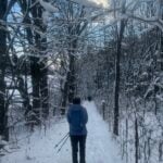
Description Moonlight Night Hike – Take in the magic of the rising moon over Lake Ontario and the Niagara River. This hike includes a stop to connect with your senses – sights, sounds, smells and the rhythm of your breath. Counts towards your night hike badge (5 night hikes).
Pace: Medium – 3 to 4 km/hr Terrain: Dependent on Conditions, Moderate – Some hills and/or some poor footing Distance: Approx 6 km
Description Please be at parking by 7:15 pm as the hike will leave promptly at 7:30 pm.
The Full Worm Moon is the third full moon of 2026. Depending on the weather, please bring your poles and icers; dress in layers to keep warm. Bring enough water and snacks to suit your needs. Please remember to bring your headlamp or flashlight. Headlamps with a red or green light setting are the most wildlife friendly, and best for preserving your night vision. Please ensure your device is fully charged/fresh batteries to last the duration of the hike.
We will start by following the outer road at Woodland Cemetery and pick up Grindstone Marsh Trail at Sunfish Pond. Following Grindstone Marsh Trail into Hendrie Valley, we will loop our way along the North and South Bridle Trail to Cherry Hill Gate and back to the cars. There is a set of stairs, one steep-ish downhill section, and a couple of smaller hills.
Please leave dogs at home.
This hike will qualify you for the new Iroquoia Full Moon badge! Complete three leader led-hikes in 2026, and you will qualify. Badges are $10 for BTC members/ $15 for non-members.
Any questions may be directed through “Click here to contact Hike Leader” on this form.
In the event you are no longer able to attend, please remove yourself from registration by following these steps:
– Sign into your account on the BTC website – Click on My Hikes under your account – This will take you to a list of hikes you have registered for – Scroll down to the appropriate hike and cursor over to the far right hand column under the Action column. – Click Cancel under the hike you wish to cancel
Hosting Club: Toronto Category: Car Hike Location (Google Maps): Rockway Conservation Area, near km 46.3,enter off Pelham Rd just east of Wessel Dr (15), 43.111255,-79.321901. Parking was free in 2025 but we may need to pay now so please be prepared for this. We will shuttle to Decew House Heritage Park, km 29.9, enter from Decew Rd (10), 43.107568,-79.249598
Description Come and join us for one or more of these hikes. The remaining two hikes are March 5 and 6. Hikers must register for individual hikes. Hikes are 14-18 kms and expect an average pace of 4 km/hr with snack/lunch breaks. Please arrive in time to be ready for our 8:30 departure.
Hikers should be prepared for the season – layered clothing, hiking boots, icers, snowshoes (if we get fresh snowfall), poles, water, snacks/lunch, first aid kit, and icers.
Hikers should be prepared to share their cars for shuttling – to be shared evenly.
If we encounter unsafe hiking or driving conditions, I will cancel/re-schedule the hike the day before. If you are unable to join us on the day of the hike, please text me at 647-231-0946.
Hosting Club: Niagara Category: Car Pool Location (Google Maps): Meet at Merritt Island Building , 8 Merritt Island , Parking Lot Welland. Car Pool to the Smoking Buddha, 265 King Street Port Colborne.
Pace: Brisk (4-5 km/hr) Terrain: Challenging, Level 3 (Advanced – steep hills and some scrambling over boulders), Variable Distance (km): 23.5+
Description First hike of 6 to complete the Iroquoia section for the winter badge. Please register to each day hike separately. We will car shuttle to Hilton Falls and walk back. About 0.5 km extra). Hilton Falls is a paid parking. If anyone has a parking pass please let me know. Everyone is expected to share in the paring cost. Hike is about 23.5 kms, + a walk to Hilton Falls from the 401 bridge. Bring icers, snowshoes and 2litres of water. Date may change due to extreme winter conditions.
all hikers are expected to participate in the car shuttles.
Hosting Club: Caledon Hills Category: General Location (Google Maps): Hockley Valley Provincial Nature Reserve side trails. Meeting at parking lot on east side of 3rd Line EHS where access is provided to the Glen Ross Side Trail.
Pace: Medium – 3 to 4 km/hour Terrain: Strenuous – hilly with steep climbs and some poor footing Distance: 8.5 km
Description We’ll be hiking the Glen Cross Side Trail and Isabel East Side Trail, and depending on weather/snow, adding Cam Snell Side Trail.
To avoid getting chilled there will be quick stops for clothing adjustments and hydration and a short snack break just over half way through – bring your favorite hiking drink and snacks. Dress in layers, hiking boots and icers / crampons required, poles recommended. Following the hike anyone interested can enjoy a warm drink and snack at the Hockley General Store.
Hosting Club: Iroquoia Category: Good Companions Location (Google Maps): Meet at the parking lot at 1137 HIDDEN VALLEY ROAD -east side of Road -by the Hidden Valley Park washrooms(NOT the south lot off Lemonville Rd)
Pace: Medium – 3 to 4 km/hr Terrain: Dependent on Conditions, Easy – Mostly flat and usually good footing, Moderate – Some hills and/or some poor footing, Slippery Sections Likely Distance: 7 km
Description We will start in the Hidden Valley and make our way along the Grindstone Creek to the RBG Hendrie Valley Sanctuary.
Taking the South Bridle Trail over to the boardwalk overlooking the beautiful marsh and all of its inhabitants we will make our way back along the North Bridle Trail.
It is a lovely walk along the marsh. If you are a birder you might want to bring your binoculars.
Spring like conditions-wet areas-dress for the weather, bring water, hiking poles, icers, snack
Location (Google Maps): Meet on the shoulder of 21st Sideroad where the road allowance heads up to the trail, east of where the trail comes out at km 8.3, Map 24, Edition 31, paid parking.
Pace: Medium Terrain: Moderate Length of Hike: Approx. 6 km
Description We will be hiking to Loree Forest loop, with views above the ski clubs, mostly flat terrain with one climb up the road allowance to the trail.
On winter hikes we may encounter bare ground, light snow, deep snow, or ice. Please bring snowshoes and icers to our Winter Wednesday Walkers outings. Wear appropriate clothing for the weather plus water and a snack.
COVID-19 Precautions Before, During and After your Hike
Each hiker joining a Bruce Trail Club organized hike must perform a self-screening check before hiking. Find Ontario’s self-assessment tool here: https://covid-19.ontario.ca/self-assessment/
If you are experiencing COVID-19 symptoms, stay home.
Other Guidelines
Arrive 15 minutes before the start of the hike.
Wear sturdy footwear and appropriate attire for the weather and the terrain. Hiking poles are a good idea in any season, especially if the terrain is rocky or slippery. In winter, snowshoes or icers/crampons are needed when conditions dictate. Wearing appropriate clothing and footwear prevents injuries and shows consideration for a safe and positive group hiking experience.
Always carry I.D. and your health card.
Bring sufficient water and snacks (or lunch if indicated). A minimum of 1L of water is recommended on all hikes, and 3L is recommended for long, challenging hikes in the heat of the summer.
Bring sunscreen and insect repellent (for spring and summer hikes).
Hosting Club: Sydenham Category: An evening walk. Location (Google Maps): Meet in the municipal parking lot by the river on the West side of 1st Ave East between 7th St Est and 8th St East in Owen Sound
Pace: Medium: 3 to 4 km/h Terrain: There might be icy and slippery sections. Distance: Approx 5 km
Description Join us for a Full Moon (the Worm Moon) evening hike exploring Sydenham Valley neighbourhoods right in Owen Sound, followed by an opportunity to socialize over refreshments. If conditions are snowy, please wear icers/grippers, as the sidewalks may be icy. There is no need to show up 15 minutes early for this hike, but we will leave promptly at 7:00 pm.
Hosting Club: Toronto Category: Car Hike Location (Google Maps): Meet at the parking area off of Cave Springs Rd, access main trail via Margaret Reed Side Trail, near km 64.9, GPS 43.150026,-79.446539. We will shuttle to Rockway CA, enter off Pelham Rd just east of Wessel Dr, near km 46.3, GPS 43.111255,-79.321901. Parking fee at Rockway CA will be shared among passengers and driver does not pay.
Description Join us for one or more of these hikes! Hikers must register for individual hikes. Hikes are 14-18 kms and expect an average pace of 4 km/hr with snack/lunch breaks. Please arrive in time to be ready for our 8:30 departure.
Hikers should be prepared for the season – layered clothing, hiking boots, icers, snowshoes (if we get fresh snowfall), poles, water, snacks/lunch, first aid kit, and icers.
Hikers should be prepared to share their cars for shuttling – to be shared evenly.
If we encounter unsafe hiking or driving conditions, I will cancel/re-schedule the hike the day before. If you are unable to join us on the day of the hike, please text me at 647-231-0946.
Pace: Brisk (4-5 km/hr) Terrain: Challenging, Level 3 (Advanced – steep hills and some scrambling over boulders), Variable Distance (km): 23.5 km
Description 2nd hike of the Iroquoia winter E2E. We will car shuttle to Twiss rd and 8 and walk back. Please bring icers, snowshoes and 2 litres of water. Hike date may changed due to bad winter conditions. Be 15 minutes early. Expect to be moving at a pace of 4.5 km per hour.
Location (Google Maps): Parking lot is off Sycamore Drive, East of Bayview , across Starbucks plaza Bus 91 from Finch East station stops at Sycamore station.
Pace: Moderate (3-4 km/hr) Terrain: Hilly, Level 2 (Intermediate – some hills and uneven surfaces, rocks and roots underfoot), Variable Distance (km): 6-7 km
Description We will explore Valleyview and Maple View parks, and walk along German Mill Creak, in return we stop in Huntington park and have snack under beautiful shed.
Although this is considered an “Urban Walk”, you can expect some hills up and down and uneven surfaces with tree roots. Please bring hiking poles, Ice cleats water and snacks.
Pace: Leisurely: 3 km/h or less Terrain: Easy: Mostly flat and good footing., There are crevices or holes which may be hidden by layers of snow. Hike with extreme caution., There might be icy and slippery sections., There might be sections with water on the trail. Distance: 5.6 km
Description
This loop will take us on the red trail in the Springmount Forest. Fairly easy terrain. Be prepared to snowshoe but also bring spikes in case you decide snowshoes aren’t needed for yourself. Bring water and a snack. There are snowmobiles that share some of the trail but only in a few small sections.
Hosting Club: Toronto Category: Car Hike Location (Google Maps): Meet at the Grimsby Pool – 1 Elm St. Grimsby, 43.193201, -79.565301. We’ll shuttle to the parking area off of Cave Springs Rd and access the main trail via Margaret Reed Side Trail, near km 64.9, GPS 43.150026,-79.446539 to begin our hike.
Description This is the last hike of this Niagara E2E and therefore, badge day for hikers who have completed the Niagara section. Please have $10 ready if you wish to purchase a Winter E2E badge.
Hikers should be prepared for the season – layered clothing, hiking boots, icers, snowshoes (if we get fresh snowfall), poles, water, snacks/lunch, first aid kit, and icers. Please arrive so that you’re ready to leave with our 8:30 shuttle.
Hikers should be prepared to share their cars for shuttling – to be shared evenly.
If we encounter unsafe hiking or driving conditions, I will cancel/re-schedule the hike the day before. If you are unable to join us on the day of the hike, please text me at 647-231-0946.
Description Each Friday we will explore different neighbourhoods, trails and parkland throughout Historic Niagara-on-the-Lake.
Moderate pace with some weeks entirely on sidewalks and roads while others may include a mix of trails and paved pathways. Great way to build up endurance for longer more strenuous hikes.
Prepare for cooler windy conditions on open parkland and along Lake Ontario and Niagara River trails.
Plan to stay for conversation and a warm cup of coffee or tea at Sweets & Swirls, Community Centre, Niagara Stone Road, NOTL
Hosting Club: Iroquoia, Caledon Hills Category: Stained Glass Badge End to End Fundraiser Hike Location (Google Maps): Day 1 – Sat, Mar 7 – Meet at Mono Community Centre, 200m south of Mono Centre (County Road 8). Park in gravel lot. https://maps.app.goo.gl/hW5VcpFWCBhAe5xq7 Shuttle to BT parking lot on the east side of the 5th Line EHS just south of the Hockley Rd https://maps.app.goo.gl/JgGmJD9tjqh1KBGJ7 ~ 21.50km
Day 2 – Sun, Mar 8 – Meet in BT parking lot on the east side of the 5th Line EHS just south of the Hockley Rd https://maps.app.goo.gl/JgGmJD9tjqh1KBGJ7 Shuttle to Roadside parking on Innis Lake Rd north of Finnerty Sideroad https://maps.app.goo.gl/AYqSXpPmFtc4EytN6~ 21km
Day 3 – Sat, Mar 14 – Meet at Roadside parking along the southwest shoulder of the Willoughby Rd and Escarpment Sideroad https://maps.app.goo.gl/sRMCqGTsFX2zWGNeA Shuttle to Roadside parking on Innis Lake Rd north of Finnerty Sideroad https://maps.app.goo.gl/AYqSXpPmFtc4EytN6 – 15km
Day 4 – Sun, Mar 15 – Meet at Roadside parking at Boston Mills Rd just west of the Mississauga Rd intersection. Note: driveway is private property. Shuttle southwest shoulder of the Willoughby Rd and Escarpment Sideroad https://maps.app.goo.gl/sRMCqGTsFX2zWGNeA(includes 2.47km of Toronto section) Includes 2.5km of Toronto section – 18.50km
Please save March 21 for a make-up day in the event of inclement weather.
Pace: Brisk – 4 to 5 km/hr Terrain: Dependent on Conditions, Slippery Sections Likely, Strenuous – Hilly with steep climbs and some poor footing Distance: 72km split over 4 days – daily distance dependent on parking capacities
Description This is a monetized hike with the proceeds going towards the Caledon Bruce Trail Club – “Preserving a ribbon of wilderness for everyone, forever.” Your badge depicting the white-tailed deer, the hike logistics, shared shuttle driving and hike guidance are all included in your fee. Since it is the intention to run a similar hike in all sections this year, why not join the Bruce Trail Conservancy if you are not already a member? Please use my code 67abd1234c568 until the end of 2025 to receive free digital maps as well as all the other great benefits included with membership. https://brucetrail.org/product-category/memberships/
Registered participants will receive a WhatsApp invitation (optional) which can be used for photo share.
Please read all details for this hike to ensure it is suitable for you. The pace and terrain are particularly important details.
You must be registered to participate in this group hike. You cannot just show up as there are often people on the waitlist.
This is a multi-day hike – Mar 7/8, 14/15, 2026. Please save March 21 for a make-up day in case there is inclement weather.
Please ensure your car is car shuttle-ready with at least 4 available seatbelts including the driver’s. We will take turns either being the shuttle driver or driving the drivers back to their cars after the hike is over.
Please pack whatever food you will require for a long day hike including lunch and snacks; 2l of water minimum; first aid kit; poles if you use them; and icers. You may also wish to pack extra socks and rain gear. Remember to dress in layers. Gloves/mitts, scarf / neck gator, a toque and a puffy jacket. Consider snow shoes, depending on conditions.
We will break for a morning clothing adjustment, a 10min break around 10am, 15 min lunch and an afternoon break if we are finishing after 2pm. Bio-breaks are as you need them – please let the sweep know who will wait for you. This is a 4 day group hike so it is important you keep pace with the person in front of you. We will help each other and wait for one another but please consider your physical ability before signing up for this hike. There are no drop outs – if you are not able to finish the hike you will need to arrange for transportation back to your car via taxi or Uber at your cost.
The Caledon stained-glass badge will be presented on the last day. If you have to miss one of these hiking days, you may make it up on your own before the last day of the series. Since it is a group hike, it is intended that everyone who registers be present on all days.
Any questions may be directed through contact on this form. If you cannot make it, please remove yourself from registration.
To cancel your registration, here is a step by step: – Sign into your account on the BTC website – Click on My Hikes under your account – This will take you to a list of hikes you have registered for – Scroll down to the appropriate hike and cursor over to the far right hand column under the Action column. – Click Cancel under the hike you wish to cancel
Hosting Club: Caledon Hills Category: General Location (Google Maps): WE WILL BE PARKING AT THE NORTHERN PART OF THE PARK ON DUNBY RD. – NOT AT THE MAIN PARKING LOT. Roadside parking on the south side of Dunby Rd. at km 67.8
Pace: Medium – 3 to 4 km/hour Terrain: Strenuous – hilly with steep climbs and some poor footing Distance: 16 km
Description Join us for a 16 km hike through the Nature Reserve, known for being one of the most challenging and hilly sections of the Bruce Trail. Get ready for a workout.
We will be hiking at a moderate-fast pace. Please bring plenty of water and snacks. HIKE BEGINS AT 8:30 AM.
We are committed to providing an inclusive and welcoming environment. This hike is an 2SLGBTQIA+ safe space, and everyone is welcome to join us!
Pace: Moderate (3-4 km/hr) Terrain: Challenging, Hilly, Level 2 (Intermediate – some hills and uneven surfaces, rocks and roots underfoot), Rocky Distance (km): 18
Description This is DHBTC E2E in 4. E2E hikers are rewarded the club coveted E2E badge upon completion. However, joiners must complete the four series hikes to earn their badge. Missed segment/s must be made up prior to the completion of the last leg to receive their badge. We’ll be on a moderate pace to enjoy, see and feel the stunning landscape and acquaint ourselves with the other souls on the group. Day hikes essentials to bring, lunch/snacks, sufficient preferred liquid hydration, sun screen, bug spray, head covering for sun protection, appropriate clothing for the weather, personal medication/s (if any), health card, happy face and your enthusiasm. Hiking shoes and poles are highly recommended. Please note that “Icers are Mandatory” to carry from the on set of Winter to mid-April. Showing up at meet up location for non-compliance will result to be refuse joining the group. Make sure you and your car are shuttle ready as everybody are expected to participate. Cost of badge is 10 dollars for BTC member and 15 dollars for non-member.
Please arrive fifteen minutes early for car shuttling.
This is a H4H-H4F !!! hike. If this schedule suits you, your welcome to join.
Note: To reach the specific parking lot location, use GPS Coordinates, specified in the meet-up location above.
Hosting Club: Toronto Category: Car Hike Location (Google Maps): Oak Ridges Corridor, Bethesda Trail Head Parking Lot, Bethesda Side Road, Richmond Hill, Ontario
Pace: Leisurely (2-3 km/hr) Terrain: Challenging, Level 2 (Intermediate – some hills and uneven surfaces, rocks and roots underfoot), Variable Distance: 10 km
Description We will be hiking in winter conditions of ice and snow so these will be slower and shorter hikes than in other seasons. Icers or snowshoes are mandatory, and gaiters and poles recommended. The terrain is not too hilly, but the footing is treacherous in winter with many uneven, rocky sections to navigate. The leaders will let registrants know in advance if snowshoes are feasible for the day. Please bring at least 2L of water, snacks, and your lunch. Any hikers are welcome to join the hikes regardless of whether a person is working towards a badge. Those who complete all 6 hikes will qualify for the Toronto club’s Winter E2E badge. The fee is $10 per badge ($15 for non-members) and will be collected by the hike leader on trip #4. Or you may choose to purchase the special Fundraising End to End badge for $30.
This fifth hike in the series will take us through Silver Creek and Terra Cotta Conservation Areas from the Eighth Line side trail to the Terra Cotta parking lot on Winston Churchill Blvd. There will be a refreshment/social stop in Georgetown after the hike before returning to the York Mills Station departure point by 6:00 PM.
Description Meet in Sobey’s Parking lot near the intersection of Glendale and Merritt St.
We will make a figure 8, hiking along the Merritt Trail, around Richart Pierpoint Park, then back towards Sobey’s Parking lot. The top half of the hike will follow the Main trail, then link up with the Merritt Trail and return to Sobey’s Parking lot.
Description Start and finish in Jaycee Gardens Park. Mostly urban hike with some trails mixed in. Walking the Green Ribbon Trail. Bring water and snack. Wear hiking shoes with good grip, may be some icy spots. May use poles with tips.
Pace: Medium – 3 to 4 km/hr Terrain: Moderate – Some hills and/or some poor footing Distance: 8 kms
Description Meeting at 9:15 am, we will hike the main trail from Speyside, to the Al Shaw ST, Hilton Falls ST and onto the Vanderleck ST up to 17 Side Road and then return the same way. There are some very technical (rocky) sections on this hike but no major hills. Bring icers for your boots, in case we have snow. Hike is dependent on weather.
Hosting Club: Caledon Hills Category: General Location (Google Maps): Starting from the Cheltenham Brickyards Trans Canada Trail parking lot on Mississauga Road.
Pace: Leisurely – 3 km/hour or less Terrain: Moderate – some hills and/or some poor footing Distance: 4.5 Km
Description This is a loop hike in Cheltenham. We will hike along the Trans Canada Trail, through Cheltenham and back to the Brickyards. A stop at the Cheltenham General Store will be included.
Location (Google Maps): Meet in the laneway of Norine & Garth’s home, 412 Quiet Valley Road. GPS does not always go to this address properly so here are the details. Quiet Valley Road is south off Epping Road/Sideroad 19. To access Sideroad 19 from the west use Grey Rd. 7 just south of The John Muir/Epping lookout (Quiet Valley Rd will be off Sideroad 19 on your right down the big hill). To access Sideroad 19 from the east use Grey Rd. 13 south of Heathcote (Quiet Valley Road will be off Sideroad 19 on your left before the big hill).
Pace: Medium Terrain: Moderate Length of Hike: 1.5 to 2 hours, approx. 5 km
Description SOUP’S ON! Join us for a lovely snowshoe on the adjoining properties of Norine & Garth and Betty & Mike, where mature forest offers protection from the wind and views of Old Baldy may be seen if it’s a clear day. Afterward we’ll enjoy a warming lunch in Norine & Garth’s home. They will provide the soup, plus coffee & tea and you’ll bring a sandwich, or your choice of accompaniment to go with it. If you’d like to bring goodies to share for dessert, feel free! Folks are welcome to show up just for the lunch, or conversely, just for the hike, or both. If you are there just for lunch, please arrive about 12:00p.m. We may still be on the trail. Depending on the conditions, we may use snowshoes, icers or just boots, so please come prepared. If you have any questions please contact beavervalleytrailactivities@gmail.com. The hike leader will inform the group in the morning on March 7 if weather conditions preclude the hike. Hope to see you there! Please car pool if possible.
COVID-19 Precautions for your Hike
Each hiker joining a Bruce Trail Club organized hike must perform a self-screening check before hiking. Find Ontario’s self-assessment tool here: https://covid-19.ontario.ca/self-assessment/
If you are experiencing COVID-19 symptoms, stay home.
Transportation
All hikers are responsible for their own transportation to and from the hike.
Currently, there are no car shuttles on hikes – all hikes must be out-and-back or loop hikes.
Other Guidelines
Arrive 15 minutes before the start of the hike.
Wear sturdy footwear and appropriate attire for the weather and the terrain. Hiking poles are a good idea in any season, especially if the terrain is rocky or slippery. In winter, snowshoes or icers/crampons are needed when conditions dictate. Wearing appropriate clothing and footwear prevents injuries and shows consideration for a safe and positive group hiking experience.
Always carry I.D. and your health card.
Bring sufficient water and snacks (or lunch if indicated). A minimum of 1L of water is recommended on all hikes, and 3L is recommended for long, challenging hikes in the heat of the summer.
Bring sunscreen and insect repellent (for spring and summer hikes).
Pace: Medium – 3 to 4 km/hr Terrain: Dependent on Conditions, Moderate – Some hills and/or some poor footing, Slippery and Steep Sections Distance: Approx 6 km
Description Please be at parking by 8:15 am as the hike will leave promptly at 8:30 am.
Depending on the weather, please bring your poles and icers; dress in layers to keep warm. Bring enough water and snacks to suit your needs.
We will start by following the outer road at Woodland Cemetery and pick up Grindstone Marsh Trail at Sunfish Pond. Following Grindstone Marsh Trail into Hendrie Valley, we will loop our way along the North and South Bridle Trail to Cherry Hill Gate and back to the cars. There is a set of stairs, one steep-ish downhill section, and a couple of smaller hills.
Please leave dogs at home.
Easterbrook’s Hot Dog Stand is open all winter for anyone wishing to stop in for a bite to eat.
Please note, the hike might be canceled due to extreme weather, or unsafe trail conditions. A cancellation email will be sent to all registered hikers.
Any questions may be directed through contact on this form.
In the event you are no longer able to attend, please remove yourself from registration by following these steps:
– Sign into your account on the BTC website – Click on My Hikes under your account – This will take you to a list of hikes you have registered for – Scroll down to the appropriate hike and cursor over to the far right hand column under the Action column. – Click Cancel under the hike you wish to cancel
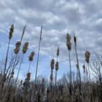
Pace: Moderate (3-4 km/hr) Terrain: Flat, Hilly, Level 2 (Intermediate – some hills and uneven surfaces, rocks and roots underfoot) Distance (km): 10-11
Description Let’s roll the hills of the Jefferson Forest this winter! Every weekend, we’ll explore the winter wonderland at this beautiful park. Located in the heart of Richmond Hill, it boasts numerous hiking trails. This 3-hour hike can range from 10 to 12 kilometres, depending on the weather conditions. Remember to bring water, snacks, hiking boots, icers, poles, and your camera. Not recommended for beginners. Park in the free Bethesda parking lot and avoid parking along the road. Dress appropriately for the weather. Difficulty Level: 2 (Moderate).
Please arrive @8:45AM for start of 9:00AM.
This is a joint hike with the Oak Ridges Trail Association (ORTA).
Hosting Club: Toronto Category: Car Hike Location (Google Maps): We will meet at the Trafalgar & 401 Commuter Lot (43.571569, -79.831797) and then carpool to the start of the hike.
Pace: Leisurely (2-3 km/hr), Moderate (3-4 km/hr) Terrain: Level 2 (Intermediate – some hills and uneven surfaces, rocks and roots underfoot) Distance (km): 10.8 km
Description This is the fourth in a series of five hikes that will be offered approximately one Sunday per month so that participants can earn the Toronto Side Trails Badge during the winter and early spring. Each out-and-back hike will cover a distance of 8-11 km and be hiked at a leisurely to moderate pace (approximately 3 km/h). Please note that the hikes will be posted separately on the BTC calendar – you will have to register for each hike that you’re interested in joining.
For this fourth hike we will explore one long side trail in the Toronto section of the Bruce Trail: the Vanderleck Side Trail.
Please dress appropriately for a winter hike by dressing in layers (wear an inner layer that wicks sweat away from your skin, a middle layer that keeps you warm, and an outer layer that protects you from wind and snow), wearing gloves/mittens and a toque, and wearing warm and comfortable footwear that has good traction in snow/ice (icers placed over your boots work great!). Hiking poles or walking sticks are an asset since they will help keep you balanced if the ground is slippery. As well, make sure you bring enough water and food for a 4 hour hike since we’ll be covering a total distance of 10.8 km over terrain that has some hills and exposed rocks.
Since parking might be limited at the places we’ll be hiking in this hike series, we will meet at the Trafalgar & 401 Commuter Lot (43.571569, -79.831797) and then carpool to the start of each hike. Please be prepared to participate in each carpool by ensuring you have space in your car if you are not already carpooling with others to the Commuter Lot meeting point.
After the hike, interested participants can join me at the Tim Horton’s on Trafalgar Road just a bit south of Highway 401 for some post-hike refreshment.
Looking forward to exploring some of Toronto’s side trails with you!
Hosting Club: Toronto, Beaver Valley Category: Urban Walk Location (Google Maps): Meet at Matt Cohen Park on South East corner of Spadina and Bloor across from JCC and Scotia Bank Toronto Nordheimer Ravine to Cedarvale Ravine through Wychwood park.
Pace: Moderate (3-4 km/hr) Terrain: Flat, Level 2 (Intermediate – some hills and uneven surfaces, rocks and roots underfoot), Other (Refer to Description) Distance (km): 10 km
Description Join Marina on her “graduation hike” to become a certified TBTC Hike Leader. The hike is open to members and non members, to all who want to celebrate IWD and support women, community, nature, and movement. The hike will follow part of the route of Castle Frank Brook, a waterway that once carved a path through midtown Toronto until the 1930’s, when it was buried. We’ll hike some of its stream valleys that now make up part of Toronto’s ravine system.
What to expect:
We’ll start our hike from Matt Cohen Park close to Spadina TTC station and head to Roycroft park and the Nordheimer Ravine trail where the CFB flowed. We’ll cross over to Cedarvale Ravine, where the trail offers short glimpses of water from the Brook. On our hike we’ll see signs of spring in the cattail wetlands. We’ll pass a 200 year-old elm tree and hike through Toronto’s historic Wychwood Park and see Taddle Creek pond. The Hike will finish at Bathurst and Dupont streets, a short bus ride or walking distance to Bathurst Subway station. Everyone is welcome to join us for a post hike bite and refreshment at Annex Social on Bathurst Street.
The hike goes ahead rain, snow or shine
What to Bring:
**The pathways in the ravine can be icy so ice traction footwear such as Crampon’s or Yaktrax are mandatory**
Pace: Medium – 3 to 4 km/hr Terrain: Easy – Mostly flat and usually good footing Distance: 8 Kms
Description Celebrate International Women’s Day with an easy, social out-and-back urban hike along Hamilton’s waterfront. We will meet at 9:45 a.m. for a 10 am departure. We’ll walk from Bayfront Park to Princess Point on flat, paved paths at a relaxed pace, with time to enjoy the views and good conversation.
This walk is open to all who want to mark the day by getting outside together and celebrating women, community and movement.
What to Bring: • Water, snacks, perhaps a hot beverage. • Dress in layers.
Everyone is invited to join us for a post-hike coffee/tea on James St North.
Email any questions to the Hike Leader – “Click here to contact Hike Leader” on this form.
If you cannot make it, please remove yourself from registration by following these steps:
To cancel your registration, here is a step by step: – Sign into your account on the BTC website – Click on My Hikes under your account – This will take you to a list of hikes you have registered for – Scroll down to the appropriate hike and cursor over to the far right hand column under the Action column. – Click Cancel under the hike you wish to cancel
Pace: Moderate (3-4 km/hr) Terrain: Flat Distance (km): 10.4 km
Description Please join me at the south west corner of Lakeshore Blvd West and Ellis by 10 AM. We will hike east along the Waterfront Trail to the Distillery District (km 8.3 to km 71.4). Here is an online map with km markings of our route for all 7 hikes for the Toronto Urban Badge. https://onthegomap.com/s/c2c1hf3n
Please make sure you bring at least 2 liters of water, a lunch, and icers.
Description From the parking lot, we will hike along the Ice Cave Trail, the Margaret Reed Side Trail and the main Bruce Trail, stopping to explore and discuss the geology of the Niagara Escarpment, the Beamsville Bench wine region and the physiographic and geologic conditions that make it special. After a short in-and-out hike on the Ice Cave Trail, we will slowly begin an incline up the Margaret Reed side trail as we scale the Niagara Escarpment. We will consider the 450+million years of history we are hiking through as we make our way slowly to the top. We will stop along the way to discuss and rest. Once at the top, the terrain on the Bruce Trail is generally flat but footing may be uneven. It may be icy or wet and slippery. Hiking poles will make the ascent easier and give more stability on uneven footing. We will hike to the site of the very first blaze on the Bruce Trail and admire the views of Lake Ontario and the vineyards of Cave Spring and Malivoire wineries. Winter offers the most unobstructed views of this beautiful area. We will return the way we came.
Hikers that are not registered cannot be accommodated on this hike. This hike is open to members and non-members.
Pace: Medium – 3 to 4 km/hr Terrain: Dependent on Conditions, Strenuous – Hilly with steep climbs and some poor footing Distance: 9 km
Description Starting at the Dundas Driving Park, we will make our way to the Tews Falls Side Trail and hike to the Falls and make our way back taking in the Glen Ferguson Side Trail. Along the way, we will take in the Dundas Peak. The hike will be a lengthy and steady climb up all the way to the Falls and, of course, a steady descent all the way back.
Wear layered clothing appropriate to winter weather conditions, wear hiking boots, bring icers and hiking poles. Bring water and a snack.
Please arrive at the meeting place by 8:15 a.m. for an 8:30 a.m departure.
Pace: Medium – 3 to 4 km/hr Terrain: Moderate – Some hills and/or some poor footing Distance: 8 kms
Description We will meet at 9:15 am at the corner of 10 SR and 4th Line, just north of Campbellville, off Guelph Line and hike the bike trails around a big loop.
Bring icers for your boots. Hike is dependent on weather conditions.
Pace: Brisk (4-5 km/hr) Terrain: Challenging, Level 3 (Advanced – steep hills and some scrambling over boulders), Variable Distance (km): 20 km
Description 4th hike in the winter E2E series. We will car shuttle to km 58.8, Sydenham Lookout and hike back. Please bring icers, snowshoes and 2 litres of water. Hike date may changed due to bad winter conditions. Come 15 minutes early. Hikers are expected to move at a pace of 4.5 km per hour.
Description This is our regular Tuesday Long Hike. Note the new location which will continue until May due to the muddy conditions in Shorthills. We will hike along the trails which may include Brock, 12 mile creek. Morningstar mill and/or Bert Lowe side trail. Dress for the weather and bring poles snack and drink
Description Hike the main and side trails of Short Hills Provincial Park. Please note that there are some steep hills and rocky sections so you should have some hiking experience before joining this hike. Please bring water, hiking poles and icers, as the trails can be icy at times.
Hosting Club: Caledon Hills Category: Tuesday Hikers Location (Google Maps): Mono Cliffs Provincial Park. Meet in the Bruce Trail parking lot on 2nd Line EHS Mono at 09:30
Pace: Medium – 3 to 4 km/hour Terrain: Moderate – some hills and/or some poor footing Distance: Approximately 10 km
Description From the BTC parking area northeast of km 8.9 0ff of 2nd Line EHS at the beginning of the Splitrock Side Trail, we will hike the Splitrock Narrows, and Ralph Tremills Side Trails. We will connect to the Walter Tovell Side Trail to McCarstons Lake and return, possibly hiking to the Lookout Side Trail.
Bring snacks and water or other beverage. Poles and icers optional depending on trail conditions.
First aid kit, rain gear recommended.
The weather report for Tues. March 10th at this time says temperature 15/6 degrees with light rain.
If you need to cancel for any reason please let the hike leader know.
Location (Google Maps): Parking lot is off Sycamore Drive, East of Bayview , across Starbucks plaza Bus 91 from Finch East station stops at Sycamore station.
Pace: Moderate (3-4 km/hr) Terrain: Hilly, Level 2 (Intermediate – some hills and uneven surfaces, rocks and roots underfoot), Variable Distance (km): 6-7 km
Description We will explore Valleyview and Maple View parks, and walk along German Mill Creak, in return we stop in Huntington park and have snack under beautiful shed.
Although this is considered an “Urban Walk”, you can expect some hills up and down and uneven surfaces with tree roots. Please bring hiking poles, Ice cleats water and snacks.
Pace: Medium: 3 to 4 km/h Terrain: Moderate: Some hills and/or poor footing, There might be icy and slippery sections. Distance: 5 km
Description The Walk In Nature Series (WINS) consists of 2 hour hikes in the Sydenham section of the Bruce Trail that combine nature appreciation with fitness in a safe and welcoming group environment led by an experienced hike leader. Consider these hikes to be appointments with yourself in nature that promote health and fitness.
Due to difficult, even dangerous, conditions on Bruce Trails in this transition from winter to spring, this hike has been changed to a mostly urban area where footing is safe and secure. Wear hiking boots. NO need for poles, icers nor snowshoes. Starting at Harrison Park we will follow Bruce Trail’s Harrison Park side trail then up 9 bends to the Greenwood Cemetery and return to parking by the Harrison Park Inn where an invitation is open to all for refreshments in the resataurant after the hike.
Pace: Brisk (4-5 km/hr) Terrain: Challenging, Level 3 (Advanced – steep hills and some scrambling over boulders), Variable Distance (km): 18 kms
Description This is the 5th hike towards the winter E2E badge. We will car shuttle to km 22.0 Veever Park Side Trail, Green Hill Ave and hike back. Bring icers, snowshoes and two litters of water. Arrive 15 minutes early. Hikers are expected to hike in a pace of 4.5 km per hour.
Pace: Leisurely – 3km/hr or less Terrain: Dependent on Conditions, Moderate – Some hills and/or some poor footing Distance: Approx 7.5 km,
Description An old favourite, I love hiking the trails here. With luck the new boardwalk around the lake will be finished and early Spring will be on its way. We’ll get great views across to Rattlesnake as we hike along the escarpment edge (won’t be a ramble here! ). Who knows. we might even see early returning Turkey Vultures. Bring a snack, water and icers. Poles are useful for the escarpment edge. A reservation is necessary through Halton Conservation Area Parks. I will send out a pre-hike message the day before with my contact information.
Location (Google Maps): Meet at the end of North St. in Eugenia, on the shoulder, on the south side, turn cars to face east. (North St. is directly north of The Top O’ The Rock store.) km 56.1, Map 26, Edition 31.
Pace: Medium Terrain: Moderate, Some steep sections Length of Hike: Approx. 6 km
Description We’ll be hiking along the escarpment through forest to the Beaver Valley landmark “The Penstocks” and then returning to our cars. Some great views to be had! On winter hikes we may encounter bare ground, light snow, deep snow, or ice. Please bring snowshoes and icers to our Winter Wednesday Walkers outings. Wear appropriate clothing for the weather plus water and a snack.
COVID-19 Precautions Before, During and After your Hike
Each hiker joining a Bruce Trail Club organized hike must perform a self-screening check before hiking. Find Ontario’s self-assessment tool here: https://covid-19.ontario.ca/self-assessment/
If you are experiencing COVID-19 symptoms, stay home.
Other Guidelines
Arrive 15 minutes before the start of the hike.
Wear sturdy footwear and appropriate attire for the weather and the terrain. Hiking poles are a good idea in any season, especially if the terrain is rocky or slippery. In winter, snowshoes or icers/crampons are needed when conditions dictate. Wearing appropriate clothing and footwear prevents injuries and shows consideration for a safe and positive group hiking experience.
Always carry I.D. and your health card.
Bring sufficient water and snacks (or lunch if indicated). A minimum of 1L of water is recommended on all hikes, and 3L is recommended for long, challenging hikes in the heat of the summer.
Bring sunscreen and insect repellent (for spring and summer hikes).
Hosting Club: Toronto Category: Car Hike Location (Google Maps): Meet at the Grimsby Pool, 1 Elm St at the south end of Coronation Park (GPS 43.193201, -79.565301). We’ll shuttle to the Oakridge Dr. Access Trail, km 18.2, roadside parking (GPS 43.213943, -79.742417) to begin our hike.
Description Please join for one or more of this Iroquoia series to complete the section over 7 hikes. Hikers must register for individual hikes.
Expect an average pace of 4 km/hr with snack/lunch breaks. Please arrive 15 minutes early so you’re ready for the shuttle to begin promptly at 8:30.
Hikers should be prepared for the season – layered clothing, hiking boots, snowshoes (if we get fresh snowfall), poles, water, snacks/lunch, first aid kit, and icers.
Hikers should be prepared to share their cars for shuttling – to be shared evenly.
If we encounter unsafe hiking or driving conditions, I will cancel/re-schedule the hike the day before. If you are unable to join us on the day of the hike, please text me at 647-231-0946.
Pace: Brisk (4-5 km/hr) Terrain: Level 3 (Advanced – steep hills and some scrambling over boulders) Distance (km): 22 km
Description Badge day, treats day. Bring 2 litres of water. Bring icers and snowshoes to be able to hike in any trail conditions. Date of hike may need to be changed due to bad winter weather conditions. Please arrive 15 minutes early. Hikers are expected to walk at a 4.5 km per hour.
We will car shuttle to Greenhill Ave Veever Park and hike back.
Location (Google Maps): Parking lot is off Sycamore Drive, East of Bayview , across Starbucks plaza Bus 91 from Finch East station stops at Sycamore station.
Pace: Moderate (3-4 km/hr) Terrain: Hilly, Level 2 (Intermediate – some hills and uneven surfaces, rocks and roots underfoot), Variable Distance (km): 6-7 km
Description We will explore Valleyview and Maple View parks, and walk along German Mill Creak, in return we stop in Huntington park and have snack under beautiful shed.
Although this is considered an “Urban Walk”, you can expect some hills up and down and uneven surfaces with tree roots. Please bring hiking poles, Ice cleats water and snacks.
Hosting Club: Toronto Category: Car Hike Location (Google Maps): Meet at the Oakridge Dr. Access Trail, km 18.2 (GPS 43.213943, -79.742417) and we’ll shuttle to the Hillcrest Ave. ST, km 37.1 (GPS 43.246437, -79.892130) to begin our hike.
Description Please join for one or more of this Iroquoia series to complete the section over 7 hikes. Hikers must register for individual hikes.
Expect an average pace of 4 km/hr with snack/lunch breaks. Please arrive 15 minutes early so you’re ready for the shuttle to begin promptly at 8:30.
Hikers should be prepared for the season – layered clothing, hiking boots, snowshoes (if we get fresh snowfall), poles, water, snacks/lunch, first aid kit, and icers.
Hikers should be prepared to share their cars for shuttling – to be shared evenly.
If we encounter unsafe hiking or driving conditions, I will cancel/re-schedule the hike the day before. If you are unable to join us on the day of the hike, please text me at 647-231-0946
Description Each Friday we will explore different neighbourhoods, trails and parkland throughout Historic Niagara-on-the-Lake.
Moderate pace with some weeks entirely on sidewalks and roads while others may include a mix of trails and paved pathways. Great way to build up endurance for longer more strenuous hikes.
Prepare for cooler windy conditions on open parkland and along Lake Ontario and Niagara River trails.
Plan to stay for conversation and a warm cup of coffee or tea at Sweets & Swirls, Community Centre, Niagara Stone Road, NOTL
Hosting Club: Sydenham Category: Snowshoe Hike Location (Google Maps): Click the (Google Maps) link on the left to direct you to parking. GPS coordinates: 44.73324, -80.95827. Park at the curve Coles Sideroad and Taylor Sideroad, 1.0 km north of Concession. Found in the Bruce Trail Reference guidebook Edition 31, Map 34 near km 136.9
Pace: Brisk: 4 to 5 km/h Terrain: Strenuous: Hilly with steep climbs and some poor footing., There are crevices or holes which may be hidden by layers of snow. Hike with extreme caution., There might be icy and slippery sections., There might be muddy sections., There might be sections with water on the trail. Distance: 10 km
Description This strenuous snowshoe hike passes a wonderful variety of landscapes and ecosystems from wetlands to escarpment ridges. We visit one of Sydenham’s authorized campsites, Birch Camp. Our actual pace will depend on mid-March trail conditions. Regardless, the hike will require an effort that matches what would be required on a summer hike of a brisk pace of 4-5 km/h. Be prepared for a good workout in the snow or mud, or wet or all of these! Registrants will receive an email the day before the hike with an update of trail conditions and what to bring. Ten kilometres at a brisk pace on these trails is no easy feat, but if you’re up to the challenge, you are most welcome!
Pace: Medium – 3 to 4 km/hr Terrain: Moderate – Some hills and/or some poor footing Distance: 8 kms
Description We will meet at 9:15 in the Pear Tree parking lot on 15 Side Road and carpool to 6th Line at the Halton Agreement Forest and hike back along the Hilton Falls Side Trail, Al Shaw Side Trail and the main trail. This trail has some serious rocks and we cross a couple of creeks. Bring icers for your boots. Hike is dependent on weather conditions.
Pace: Moderate (3-4 km/hr) Terrain: Challenging, Hilly, Level 2 (Intermediate – some hills and uneven surfaces, rocks and roots underfoot), Rocky Distance (km): 14
Description This is DHBTC E2E in 4. E2E hikers are rewarded the club coveted E2E badge upon completion. However, joiners must complete the four series hikes to earn their badge. Missed segment/s must be made up prior to the completion of the last leg to receive your badge. We’ll be on a moderate pace to enjoy, feel and see the stunning landscape and acquaint ourselves to the others souls on the group. Day hikes essentials to bring, lunch/snacks, sufficient preferred liquid hydration, sun screen, bug spray, head covering for sun protection, appropriate clothing for the weather, personal medication/s (if any), health card and your happy face and enthusiasm. Hiking shoes and poles are highly recommended. Please note that “Icers” are now mandatory on all hikes from the on set of Winter to mid-April. Showing up at meet up location for non-compliance will result to be refuse joining the group. Make sure you and your car are shuttle ready as everybody are expected to participate. Cost of badge is 10 dollars for BTC member and 15 dollars for non-member. Please arrive fifteen minutes early for car shuttling.
This is a H4H-H4F !!! hike. If this schedule suits you, your welcome to join.
Note: to reach the specific parking lot location, use the specified GPS Coordinates at the meet-up location above.
From Highway 404 turn right to Stouffville Rd, till to the end of road and turn left on York Durham line in About 1km turn right to Webb rd. and turn right to Concession Road 2 ,you will see parking lot in 500 meter.
Pace: Moderate (3-4 km/hr) Terrain: Hilly, Level 2 (Intermediate – some hills and uneven surfaces, rocks and roots underfoot) Distance (km): 12-14 km
Description Please bring at least 2L of water, a snack, sun screen and bug spray.
Some safety procedures during the hike:
1-Hikers must stay between the leader and the sweep.
2-Hikers must advise the leader or the sweep if they wish to leave the group.
3- Hikers must follow the whistle instructions: 1 blast- stay where you are; 2 blasts come to the leader; 3 blasts – come to the leader quickly.
4-Hike leader may request volunteers to stop at trail intersections, they need to help hikers to the direction the group walk and wait till they see the sweep .
5-Hikers have to make sure they can see the persons behind and in front of them.
Pace: Leisurely (2-3 km/hr) Terrain: Challenging, Level 2 (Intermediate – some hills and uneven surfaces, rocks and roots underfoot), Variable Distance (km): 9-11 km
Description Come join us for the final bus hike of Winter, 2025-2026. The hike will cover the last 2.5 km of the Toronto section of the Main Bruce Trail and then follow the western section of the Caledon Trailway back to Terra Cotta Conservation Area. For those who have been on the five previous Winter Badge E2E hikes, completing this bus trip will qualify you for the awarding of the badge on this hike. For anyone taking this hike, it will be a moderate hike over the path of a former Canadian National (CN) rail line, originally built in 1877. Since the path is over the old rail bed, it is well-drained and well-surfaced, flat, and straight. However, it goes through woods and meadows, and we are already seeing there spring migratory birds like red-winged blackbirds and flocks of cedar waxwings. A celebration of the ending of the winter bus hikes and social hour will be held in Georgetown after the hike. Any hikers joining us for the very first time on a hike with the club on the Bruce Trail will receive a “My First Hike” badge.
Description Meet at the parking area on Quarry Rd in Beamsville where the trail crosses the road. We’ll hike to 30 Rd, taking a variety of side trails through Mountainview Conservation Area. We’ll check out 9 Acres Organic Farm, where there recently was a fire in their barn. 😢
Then we’ll hike back to our cars. There’s about 4 km road work involved on this hike.
Description We will hike through Dufferin Islands, Casino, Victoria Park and under the Rainbow Bridge and of course along by the Falls – something for everyone. Mostly paved walking.
Hosting Club: Iroquoia Category: Special Event Location (Google Maps): 134 Martin Road, Ancaster, ON. Parking beside Ancaster Baseball Matthew Kroll Field (unpaved lot)
Pace: Fast – 5+ km/hr Terrain: Dependent on Conditions, Moderate – Some hills and/or some poor footing, Slippery Sections Likely Distance: 10 km
Description *Originally scheduled for March 7; and moved to March 14 due to weather conditions*
Are you curious about trail running but not sure how / where to get started?
Come join a guided trail run where you can learn the ropes while taking in the beauty of Dundas Valley in a small group setting.
What to expect:
After a brief warmup, we’ll hit the trails and do an approximately 10 km loop through Dundas Valley Conservation Area, primarily on the Headwaters Trail. This section of trail is used for local trail races and features a hilly section known as “The Three Sisters.”
To accommodate different paces and trail conditions, this will be a hike/run, where we will lightly jog flat and downhill sections and hike uphill sections, with some light instruction provided along the way.
Requirements:
-Registration is required for this event.
-Please wear trail running shoes; road running shoes are not suitable for this trail.
-Bring icers to put on your trail shoes for added traction, as the trail may be slippery at this time of year. Dress in layers for warmth. Bring water and a small snack for your needs.
Recommended:
-Hydration vest or run belt for carrying water and snacks.
Interested in getting informed before hitting the trails? Burlington Runners Club recently announced they will be hosting a “Welcome to the Trails” series, which includes 1-2 interactive sessions covering various topics such as safety, trail etiquette, essential gear and hydration and nutrition tips. Check out @Burlingtonrunnersclub for more details + session dates.
Notes:
In the event of poor weather or trail conditions, I will need to cancel this event, for safety reasons.
Pace: Medium – 3 to 4 km/hr Terrain: Dependent on Conditions, Slippery and Steep Sections, Slippery Sections Likely, Strenuous – Hilly with steep climbs and some poor footing Distance: 26.68km
Description Join us in the Iroquoia End-to-End in 6 starting in March 14, 2026 for 6 hikes. Each hike will be approximately 15-26 kms at a moderate pace. This is suitable for intermediate to advanced hikers. (No children or pest on this hike)
We will be using hiker’s vehicles to shuttle between our start and end point for each hike. As well, there will be costs at some parking location, the cost will be shared.
Please note the longer distances and be physically prepared to hike at a 3-4 km pace. Proper hiking boots is a must! Bring hiking poles, food/snacks, water, hat, layers and rain gear. *Icers/Crampons are recommended.
Arrive at 8:30am at the Meet Up Point for roll call/check in/drive to the starting point. Hike will start at 9 am.
It is important to complete each section within a time frame to consider the shorter days.
Hikers will receive their End-to-End 6 Jefferson Salamander Badge upon completion on the last hike day.
If you must miss a day but can make it up before the last scheduled hike, you will still qualify for this special Jefferson Salamander badge which represents an endangered species sometimes seen in the Iroquoia section. This is a fundraising hike for the Iroquoia Bruce Trail Club. Proceeds go to the mission of protecting this ribbon of wilderness, the Bruce Trail.
All logistics/scheduling/start/stop and parking (shared cost if there is a fee) and a hike leader to guide you, is included. provided in February, closer to the start date.
__________
Day 1 – March 14, 2026/ Meet Up: Kilbride School, Panton St, Burlington (Please park in the back) 43.427756, -79.937991 (20 car spots). Car shuttle to Hilton Falls Conservation Area.4985 Campbellville Rd, Milton 43.505705, -79.961589 (100 car spots) Hiking Distance: 26.68km
Day 2 – March 15, 2026/ Meet Up: City View Park Waterdown (2nd entrance off Kerns Rd. South of Dundas St.) N43.352308, W79.862585 (50 car spots). Car shuttle to Kilbride School, Panton St, Burlington – Please park in the back 43.427756, -79.937991 (20 car spots). Hiking Distance: 22.64km
Day 3 – March 21, 2026/ Meet Up: Davidson Blvd. Dundas N43.265251, W79.990490 (5 car spots). Car shuttle to City View Park Waterdown (2nd entrance off Kerns Rd. South of Dundas St.) N43.352308, W79.862585 (50 car spots). Hiking Distance: 21.94km
Day 4 – March 22, 2026/ Meet Up: Chedoke Golf Club parking lot, Hamilton N43.246205, W79.906935 (40 car spots). Car shuttle to Davidson Blvd. Dundas N43.265251, W79.990490 (5 car spots). Hiking Distance: 15.24km
Day 5 – March 28, 2026/ Meet Up: Glover Mountain Rd. Side Trail roadside parking, Stoney Creek N43.209155, W79.773801 (10 car spots). Car shuttle to Chedoke Golf Club parking lot, Hamilton N43.246205, W79.906935 (40 car spots). Hiking Distance: 17.58km
Day 6 – March 28, 2026/ Meet Up: Grimsby Lions Community Pool 1 Elm St, Grimsby N43.193201, W79.565301 (30 car spots). Car shuttle to Glover Mountain Rd. Side Trail roadside parking, Stoney Creek N43.209155, W79.773801 (10 car spots). Hiking Distance: 21.33km
This will be a great challenge and accomplishment, you’ll meet some great people and enjoy our beautiful section of the Bruce Trail. But, remember to have fun!
Description On March 14, 1793, Chloe Cooley, was an enslaved Black woman living in Niagara, who fought for her freedom, and the freedom of thousands like her. On that date, her brave act of resistance led to the enactment of the first piece of legislation to limit enslavement in Great Britain AND the gradual abolition of enslavement in Canada. It also set the stage for the great freedom movement of enslaved African Americans known as the Underground Railroad. We will hike to where her powerful act of bravery is thought to have taken place and is marked with a plaque.
This hike will take us along the General Brock Side Trail (GBST) and on then on the Niagara Parkway (NP). The GBST’s terrain is hilly/moderate. After stopping at the plaque, we will partially retrace our steps, then climb a long set of metal stairs to take note of another plaque before returning to our cars.
The terrain may be icy and/or snow covered. Hiking poles and icers are advised, depending on the conditions. The main parking lot will be closed for the winter so park near the washrooms. A parking fee applies.
PLEASE NOTE: This hike counts as 1 of the 3 required hikes towards the Black History badge. If you have completed 3 hikes, and are interested in receiving a badge, please let me know.
For much more information about Chloe Cooley and Ontario’s Black history, open the link below. There are several very interesting videos embedded within the TVO Today 2023 article.
Pace: Medium – 3 to 4 km/hr Terrain: Dependent on Conditions, Easy – Mostly flat and usually good footing Distance: 10km
Description Join us for a leisurely loop and stellar views through the Hamilton portion of the Bruce Trail and Mountain Brow Blvd/Mountain Park Ave.
🌈 This queer-led, all-inclusive 2SLGBTQIA+ hike is designed to provide a safe, welcoming space for 2SGBTQIA+ hikers—including trans, gay, lesbian, bisexual, queer, Two-Spirit, intersex, asexual, allies and friends. Show up, be your authentic self!
Please plan to arrive for 9:45am as we will leave at 10am prompt. We will depart from the base of the Wentworth stairs and walk the paved portion of the trail/Rail Trail to the Margate Stairs (380 stairs, metal with traction and rails). We’ll go up the stairs and take Mountain View/Concession/Mountain Park back to the Wentworth Stairs (498 stairs, metal with traction and rails) and walk down the stairs to end where we started.
Please pack a lunch! Plan for a lunch break at the top of the Margate Stairs. There is a water fountain and benches there we can catch our breath before finishing the brow and Wentworth stairs.
🚗 🚌 This outing is accessible by car or public transit. Parking available on side streets, start of hike is accessible by HSR Bus #05 (Delaware) at Wentworth Ave.
🐾 Dogs are welcome on this hike! For everyone’s safety and enjoyment, pups must be fully trained and kept on a non-retractable leash at all times. Please ensure you pack out all your dog’s waste.
Visit “Dogs on the Bruce Trail” for further information. https://brucetrail.org/dogs-on-the-trail/
What to Bring: • Water, snacks, and lunch, perhaps a hot beverage. • Sunscreen, sunglasses, comfortable walking shoes/runners. • Dress based on weather.
Free Bruce Trail Rainbow badges and stickers for all participants! Questions? Simply click “Contact Hike Leader” on the registration form.
Hosting Club: Toronto Category: Cancelled Location (Google Maps):
Meet by the TTC Stop on the Southeast Corner of Scarlett Road and Eglinton Avenue West. Take the #79 Scarlett Road bus from Runnymede Station to Eglinton or the Eglinton West #32A from Eglinton West Station to Scarlett Road.
Pace: Leisurely (2-3 km/hr) Terrain: Level 1 (Easy – mostly on flat, well maintained trails with hard-packed surface), Variable Distance: 10-12 km
Description This hike has been CANCELLED
Leisurely hike (3 kms/hour – No Racers Please) suitable for beginners and families. Hike along the Humber River trail and into the Swansea village at Runnymede road and Bloor street west. The hike will end opposite Runnymede Subway near the Village Playhouse Theatre and local restaurants and pubs. Distance may vary according to the weather and trail conditions and how people feel. Early dropout is possible at Old Mill Subway Station.
After the hike you may choose to join us for dinner at around 6 PM at Ali Baba Mediterranean restaurant or at a nearby pub. We will attend the play “These Shining Lives” at 8 PM at The Bloor West Village Players theatre, 2190 Bloor Street West, Toronto. Call the Theatre directly at (416) 767 7702 to reserve your ticket, cost $26- $29.00. Please do mention that you’re with the Bruce Trail Conservancy, Toronto Club so they know we are supporting them.
Anyone is welcome to join us for the hike only, join us for the theatre performance, or, join us for all three: Hike, Dinner and play. Paid parking is available off Kennedy Avenue north of Bloor Street West (behind the Village Playhouse Theatre building). There is no parking available at the start of the hike.
Description Please join us on Sunday, March 15th for our Maple Syrup Hike! We will begin by travelling to the village of Warkworth to attend the 38th Annual Warkworth Maple Syrup Festival. At Warkworth we will board a free shuttle bus to Sandy Flat Sugar Bush about 5 km away, where you can enjoy a pancake breakfast, horse and wagon rides, maple taffy in the snow, and take in live musical entertainment. We will then head back downtown and allow some time to visit shops, boutiques and cafés, all bursting with maple themed items. Early in the afternoon we will start hiking along the beautiful Millenium Trail and will likely continue along the Oak Ridges trail (final hiking route to be determined) for a fun relaxing hike. Return back to the City around 6.30 pm. Please note that you must bring cash to attend the Festival and participate in Festival Events. Entry to the Sugar Bush is $5 per person, the pancake breakfast is $15 (children 12 years and under $10), and sleigh rides are $3 per person. See https://warkworthmaplesyrupfestival.ca/ for more details about the Festival.
Hosting Club: Caledon Hills Category: General Location (Google Maps): Boyne Valley Provincial Park, Map 20 of the BTC Trail Guide. County Rd. 19 (Prince of Wales Rd.) Parking Area – west of km 15.2 – approximately 80 metres south of the Prince of Wales Side Trail.
Pace: Medium – 3 to 4 km/hour Terrain: Strenuous – hilly with steep climbs and some poor footing Distance: 17 km
Description Join us for an invigorating hike starting from the parking lot on Prince of Wales Rd. We’ll explore the Prince of Wales Side Trail, Primrose Loop Side Trail, main trail, and Boyne Valley Side Trail, looping back via the main trail and Prince of Wales Side Trail. Along the way, we’ll hike up the short side trail to Murphy’s Pinnacle, where you’ll be rewarded with a stunning view of the surrounding landscape – great for Instagram!
Bring lunch, plenty of water, and hiking poles if you use them, as the trail is hilly. Dress for the weather. Icers are required.
PACE IS MEDIUM
This hike is a 2SLGBTQIA+ friendly space. Everyone is welcome to join us for this adventure and enjoy the beauty of the trails together.
Pace: Moderate (3-4 km/hr) Terrain: Flat, Hilly, Level 2 (Intermediate – some hills and uneven surfaces, rocks and roots underfoot) Distance (km): 10-11 km
Description Let’s roll the hills of the Jefferson Forest this winter! Every weekend, we’ll explore the winter wonderland at this beautiful park. Located in the heart of Richmond Hill, it boasts numerous hiking trails. This 3-hour hike can range from 10 to 12 kilometres, depending on the weather conditions. Remember to bring water, snacks, hiking boots, icers, poles, and your camera. Not recommended for beginners. Park in the free Bethesda parking lot and avoid parking along the road. Dress appropriately for the weather. Difficulty Level: 2 (Moderate).
Please arrive @8:45AM for start of 9:00AM.
This is a joint hike with the Oak Ridges Trail Association (ORTA).
Hosting Club: Peninsula Category: Spring Birds and Blooms Location (Google Maps): Otter Lk loop hike: km 106.0 in the 31st Ed Ref manual – by the Cape Chin Mail Boxes, don’t go down the hill. Special Guest, Lindsay de Malmanche, third generation owner of Miller Lake Family Camp, will share her perspective on local nature, through the lens of someone who has hiked the wilds of New Zealand, and travelled to the Galapagos Islands and the Amazon rainforest.
Pace: Leisurely (2.0 – 3.0 km/h): A relaxed pace with frequent breaks and a focus on enjoyment. Terrain: Moderate: Rolling hills, mild slopes and rocky paths. Distance: 6km
Description Leaving the Cape Chin N mailbox parking area, we will progress south on the Main Trail to km 104.3 and head right on Cape Chin Meadows ST, crossing Cape Chin Rd N to the Otter Lake ST. We will hike to the birding platform, spending a few minutes to take in any new migration arrivals and harbingers of spring. After a break at the birding platform we will continue along Otter Lake ST to MT and back to the parked cars. Depending on what we see and early spring Trail conditions, this hike could take up to 2 hours. Note: though a short distance, the ground will be rocky and uneven in places. Along the shores of Otter Lake, there could be some mud. Sandhill Cranes can often be heard at Otter Lake by March 1. Will we see them? Special Guest, Lindsay de Malmanche, third generation owner of Miller Lake Family Camp, will share her perspective on local nature, through the lens of someone who has hiked the wilds of New Zealand, and travelled to the Galapagos Islands and the Amazon rainforest.
Pace: Medium: 3 to 4 km/h Terrain: Moderate: Some hills and/or poor footing, Strenuous: Hilly with steep climbs and some poor footing., There might be muddy sections., There are crevices or holes which may be hidden by layers of snow. Hike with extreme caution., There might be icy and slippery sections. Distance: 4.8 km
Description The Walk In Nature Series (WINS) consists of 2 hour hikes in the Sydenham section of the Bruce Trail that combine nature appreciation with fitness in a safe and welcoming group environment led by an experienced hike leader. Consider these hikes to be appointments with yourself in nature that promote health and fitness.
On this WINS early spring hike, discover the unique features of nature in the Pottawatomi Conservation Area along the Merle Gunby side trail, the main trail and the Memorial Forest Side Trail that lead us to a wonderful view under Jones Falls.
Registrants will be sent an email the day before the hike with an update of trail conditions and what to bring whether it be snowshoes, icers, boots or all of the above.
Pace: Medium – 3 to 4 km/hr Terrain: Dependent on Conditions, Moderate – Some hills and/or some poor footing, Slippery Sections Likely Distance: Approx 10km through Dundas Valley Conservation
Description ♣ St. Patrick’s Day honours Irish heritage, symbolizing luck, growth and national pride. Wearing something green is traditional so please do, if you like.
Please wear your icers as the path could be icy; dress in layers for warmth. Bring enough snacks and water for your needs. Our hike will take us into the DVCA where we will visit the Hermitage and the falls.
An optional lunch afterward at the Trail Cafe 286 Wilson St East, Ancaster. Please let me know through contact on this form so we can make reservation.
Hosting Club: Caledon Hills Category: General Location (Google Maps): Meet at P5 – Island Lake Conservation Area – 673173 Hurontario Street, Mono. Please aim to arrive around 9:15 so we can start promptly at 9:30.
Pace: Medium – 3 to 4 km/hour Terrain: Moderate – some hills and/or some poor footing Distance: Approximately 9 km
Description Due to expected weather conditions in Orangeville, this hike has been cancelled.
This hike will explore the trails at Island Lake. A section of the Vicki Barron Lakeside Trail is now under construction until September 2026, so the modified route follows the Lakeside Trail, includes other conservation trails, and returns to the parking on the Lakeside Trail. Be prepared for winter conditions. Wear layers and boots, bring your poles, and use your icers. You are welcome to wear your green – and have a little festive fun! Bring water and a snack, if desired. There will be a break with washrooms available. No dogs please. Reservations will be made for an optional lunch stop after the hike to continue the festivities. Hike registrants will receive an email with the details.
Location (Google Maps): Parking lot is off Sycamore Drive, East of Bayview , across Starbucks plaza Bus 91 from Finch East station stops at Sycamore station.
Pace: Moderate (3-4 km/hr) Terrain: Hilly, Level 2 (Intermediate – some hills and uneven surfaces, rocks and roots underfoot), Variable Distance (km): 6-7 km
Description We will explore Valleyview and Maple View parks, and walk along German Mill Creak, in return we stop in Huntington park and have snack under beautiful shed.
Although this is considered an “Urban Walk”, you can expect some hills up and down and uneven surfaces with tree roots. Please bring hiking poles, Ice cleats water and snacks.
Pace: Leisurely Terrain: Dependent on Conditions, Moderate Distance: 6.0 km
Description We will hike a loop on the Main trail and Great Esker side trail. Short hike can return at any time. Icers and/or snowshoes may be required.
Hosting Club: Toronto Category: Car Hike Location (Google Maps): Meet at roadside parking at the Davidson Blvd ST, km 53.9, (GPS 43.265251, -79.990490) and we’ll shuttle to the Hillcrest Ave. ST, km 37.1, (GPS 43.246437, -79.892130) to begin our hike.
Description Please join for one or more of this Iroquoia series to complete the section over 7 hikes. Hikers must register for individual hikes.
Expect an average pace of 4 km/hr with snack/lunch breaks. Please arrive early enough so you’re ready for the shuttle to begin promptly at 8:30.
Hikers should be prepared for the season – layered clothing, hiking boots, snowshoes (if we get fresh snowfall), poles, water, snacks/lunch, first aid kit, and icers.
Hikers should be prepared to share their cars for shuttling – to be shared evenly.
If we encounter unsafe hiking or driving conditions, I will cancel/re-schedule the hike the day before. If you are unable to join us on the day of the hike, please text me at 647-231-0946.
Hosting Club: Niagara Category: Car Pool Location (Google Maps): Meet at the Parking Lot at Port Dalhousie Parking Lot and Car pool to Book Depot , 67 Front St North Thorold, 43.128058, -79.202189
Pace: Medium Terrain: Moderate Length of Hike: 7.4 km
Description Mike Arkless will lead this hike. Join us for an in and out hike north of Grey Road 40 through lovely winter woods, including the Daphne and Gordon Nicholls Nature Reserve.
Pace: Medium – 3 to 4 km/hr Terrain: Moderate – Some hills and/or some poor footing Distance: 10k (approximate)
Description Drive straight in from entrance, main parking lot to your right turn from stop sign at T junction. Either Hamilton Conservation Area membership or parking fees apply. Loop of lake, as well as across the road upstream, exact route may vary. Wear boots and bring icers. One side of loop flat, other has some moderate hills. Prepare for variable conditions and footing in winter conditions. Dress in layers appropriate to weather. Bring water and snack. Hike leaves at 10am.
Pace: Leisurely (2-3 km/hr) Terrain: Flat, Level 1 (Easy – mostly on flat, well maintained trails with hard-packed surface) Distance (km): 4 km
Description Join me for leisurely evening walk south to Fort York and Trillium Park (east end of former Ontario Place site) to experience the enchantment of Lumière: The Art of Light, a free outdoor light exhibition that will transform Trillium Park into a mesmerizing display of light-based art with 14 unique installations. Cozy up at the Trillium Park fire pit which will be open nightly during March Break (weather permitting) Admission is free. Dress warmly according to the weather. After the art exhibiton we will take the 511 Streetcar to Bathurst Station.
Hosting Club: Toronto Category: Car Hike Location (Google Maps): Meet at the entrance to the Davidson Blvd. ST near km 53.9 (GPS 43.265251, -79.990490), and we’ll shuttle to km 67.8 on Snake Rd. (GPS 43.317174, -79.892363) where we’ll begin our hike.
Description Please join for one or more of this Iroquoia series to complete the section over 7 hikes. Hikers must register for individual hikes.
Expect an average pace of 4 km/hr with snack/lunch breaks. Please arrive early enough so that you’re ready for the shuttle to begin promptly at 8:30.
Hikers should be prepared for the season – layered clothing, hiking boots, snowshoes (if we get fresh snowfall), poles, water, snacks/lunch, first aid kit, and icers.
Hikers should be prepared to share their cars for shuttling – to be shared evenly.
If we encounter unsafe hiking or driving conditions, I will cancel/re-schedule the hike the day before. If you are unable to join us on the day of the hike, please text me at 647-231-0946.
Pace: Leisurely – 3km/hr or less, Medium – 3 to 4 km/hr Terrain: Dependent on Conditions, Easy – Mostly flat and usually good footing, Moderate – Some hills and/or some poor footing Distance: 6.5km plus optional 5.6km
Description Mountsberg Conservation Area is part of Conservation Halton. Did you know that as a Bruce Trail member you can get 50% off an annual pass? https://brucetrail.org/member-discounts/
Maple syrup production is the gateway to spring and we are here for it.
Please join Toronto Bruce Trail Club – Tom Swales and Iroquoia Bruce Trail Club – Ruth Moffatt as we usher in Spring with hike around Mountsberg Conservation Area. Mountsberg is part of Conservation Halton, so if you have a pass, tickets to this event are discounted. Please follow the link below. Please book your ticket for 9:30am or you might be able to purchase tickets at the gate, if available. We will assemble in the parking area, hike the Pioneer Creek Trail 6.5km, stop for pancakes (extra cost), take in all the festivities and then proceed around the optional Lakeshore Lookout Trail 5.6Km. Tickets can be obtained in advance at the link below.
Learn all about tree tapping, sap collection, syrup making and our amazing Sugar Maples!
Learn about the history of syrup making
Explore the Maple Trivia Trail and other Mountsberg trails
Sample maple sugar and syrup
Enjoy maple taffy on snow available for purchase on site
Enjoy fresh pancakes and treats by the fireside (Additional fees apply)
Sugar Rangers Challenge for kids! Earn your Sugar Rangers certificate by completing fun maple challenges!
Shop for delicious maple treats at the Country Store in the sugar bush or the Gift Shop in the Discovery Centre
Visit the Animal Barn, Raptor Trail and Raptor Centre
Play on the natural playground
NEW! Meet a Raptor: Stop by the Raptor Centre Flyway to meet one of our Raptor Centre staff and a bird
Add on a wagon ride, Talons & Tailfeathers, or a maple sugar making workshop (Additional fees apply)
Please check the weather and dress accordingly. Be sure to pack whatever snacks and lunch you would like and plenty of water and/or warm beverage. Bring icers in case the trails are still icy.
Need a ride? A shared ride from Toronto for a few people can be arranged and a shared ride from Niagara can be arranged. Please click the Contact link on this form.
Location (Google Maps): Parking lot is off Sycamore Drive, East of Bayview , across Starbucks plaza Bus 91 from Finch East station stops at Sycamore station.
Pace: Moderate (3-4 km/hr) Terrain: Hilly, Level 2 (Intermediate – some hills and uneven surfaces, rocks and roots underfoot), Variable Distance (km): 6-7 km
Description We will explore Valleyview and Maple View parks, and walk along German Mill Creak, in return we stop in Huntington park and have snack under beautiful shed.
Although this is considered an “Urban Walk”, you can expect some hills up and down and uneven surfaces with tree roots. Please bring hiking poles, Ice cleats water and snacks.
Hosting Club: Toronto Category: Car Hike Location (Google Maps): Meet at km 81.6 on Guelph Line (GPS 43.388366, -79.854231). Do not block the farm gate. We’ll shuttle to km 67.8 on Snake Rd. (GPS 43.317174, -79.892363) to begin our hike.
Description Please join for one or more of this Iroquoia series to complete the section over 7 hikes. Hikers must register for individual hikes.
Expect an average pace of 4 km/hr with snack/lunch breaks. Please arrive early enough so you’re ready for the shuttle to begin promptly at 8:30. The km markings in the 31st Ref. guide do not take into account the reroute on Brant St/Cedar Springs Rd and the actual hike is 16km.
Hikers should be prepared for the season – layered clothing, hiking boots, snowshoes (if we get fresh snowfall), poles, water, snacks/lunch, first aid kit, and icers.
Hikers should be prepared to share their cars for shuttling – to be shared evenly.
If we encounter unsafe hiking or driving conditions, I will cancel/re-schedule the hike the day before. If you are unable to join us on the day of the hike, please text me at 647-231-0946.
Hosting Club: Iroquoia, Caledon Hills Category: Stained Glass Badge End to End Fundraiser Hike Location (Google Maps): We will be meeting at Escarpment Rd an Willoughby and shuttling back to Boston Mills Rd
Pace: Medium – 3 to 4 km/hr Terrain: Moderate – Some hills and/or some poor footing, Strenuous – Hilly with steep climbs and some poor footing
Description Pace: Medium – 3 to 4 km/hr Terrain: Dependent on Conditions, Moderate – Some hills and/or some poor footing, Strenuous – Hilly with steep climbs and some poor footing Distance: 72 over 4 days ~ approximately 20km + per day.
Itinerary will be emailed to participants upon registration
Description
Overview
Important: Please do not register for this hike unless you can attend all four Fridays. You may only miss one day if necessary. This series of 4 hikes will complete the Caledon section of the Bruce Trail. The organization, guidance, logistics and stained glass badge are included in your fee. Proceeds support the Caledon Bruce Trail Club, which in turn supports the Bruce Trail Conservancy’s mission to “Preserve a ribbon of wilderness, for everyone, forever.”
For this E2E in 4, we will be following the main trail northbound. Please note that you are signing up for the entire series of 4 hikes as a Group Hike. The Caledon in 4 series is geared toward experienced long-distance hikers with the expectation of a 3 to 4 km/ hr. pace maintained over a 20km plus day. The section is approximately 62km, so daily distances will be based on available parking.
Physical Fitness
The hikes will be physical. Please ensure you have completed at least 1 to 2 20 km hikes and/or are a strong hiker who has been on the trails 5+ times this year. No dropout points have been established, and therefore, hikers who must drop out will be responsible for their transportation back to their vehicles. Please note that public transportation back to your car is nonexistent in this section. Please be honest about your hiking abilities. We will hike at a steady pace, but there will be plenty of time to take pictures and enjoy the flora and fauna of this beautiful but challenging section. This particular set of 3 hikes is intended to be Moderate. It is a group hike, so you must be able to keep pace with the person in front of you.
Attire and Daily Hikes.
Hikers will be expected to be wearing proper hiking boots and layered clothing with the expectation of warmer and possibly wet weather. Sufficient food and water for a full day of hiking is required, as well as hiking poles (if you use them), and wet-weather gear is strongly recommended. Bug spray is also suggested. Clothing adjustments and bio-breaks are as needed. Please let the sweep person know, and they will wait for you. A morning break, lunch and afternoon break will be scheduled.
Shuttling
All participants will be expected to take turns either driving to the start or driving the drivers back at the end of the day. Carpooling to our meeting spot with 2 people in the car is generally ok but we would like to minimize and equalize the driving/shuttling as much as possible so it is fair for all participants.
Leave No Trace
Please remember, like all hikes, this is a Leave No Trace hike. Pack out whatever you pack in. Do not toss anything onto or into any sections of the trail. We will also try to leave the trail better than we found it so we will be collecting collectable garbage we might see along the way. Daily volunteers to collect trail trash will be supplied with a bag. Dogs will not be welcome on this hike.
Daily
We meet for each hike at 8:30 am each day. A schedule for meetings and start locations will be sent to each participant in September. We will hike north each day. No Pets or Children.
Hike Cancellations/Rescheduling
The schedule is subject to change due to weather or trail closures.
Description Each Friday we will explore different neighbourhoods, trails and parkland throughout Historic Niagara-on-the-Lake.
Moderate pace with some weeks entirely on sidewalks and roads while others may include a mix of trails and paved pathways. Great way to build up endurance for longer more strenuous hikes.
Prepare for cooler windy conditions on open parkland and along Lake Ontario and Niagara River trails.
Plan to stay for conversation and a warm cup of coffee or tea at Sweets & Swirls, Community Centre, Niagara Stone Road, NOTL
Pace: Medium – 3 to 4 km/hr Terrain: Moderate – Some hills and/or some poor footing Distance: 8 kms
Description Meeting at 9:15 am in the parking lot, we will hike to the Falls and then around to Bent Rim 1 and back to the cars. Reserve your time at conservationhalton.ca
Bring icers for your boots. Hike is dependent on weather conditions.
Hosting Club: Iroquoia, Dufferin Hi-Land Category: Stained Glass Badge End to End Fundraiser Hike Location (Google Maps): Day 1 – Sat, Mar 21,2026 – 28.63km Meet at: Bruce Trail parking on the 1st Line East (Emergency #716599) Snow plowed in winter. (Capacity 20) https://maps.app.goo.gl/aV64P4QRZCDmY9hg6 Shuttle to: Mono Cliffs Community Centre, 200m south of Mono Centre (County Rd 8). Park in gravel lot. – https://maps.app.goo.gl/diTkzwJSaHVpQTPb6 We will hike northbound. Day 2 – Sun, Mar 22,2026 – 25.64km Meet at: Meet at: Bruce Trail parking on the 1st Line East (Emergency #716599) Snow plowed in winter. (Capacity 20) https://maps.app.goo.gl/aV64P4QRZCDmY9hg6 Shuttle to: Roadside parking on Mulmur-Nottawasga Townline, 550 metres east of Lavender Hill Rd at the cemetery – https://maps.app.goo.gl/vijVfZpJPNSCjQrj9
Please note: There is another Dufferin ETE in 4 starting today. Please do not confuse the two series.
Pace: Brisk – 4 to 5 km/hr, Medium – 3 to 4 km/hr Terrain: Dependent on Conditions, Moderate – Some hills and/or some poor footing, Slippery and Steep Sections, Slippery Sections Likely, Strenuous – Hilly with steep climbs and some poor footing Distance: Day1-28.63, Day2-25.64
Description This is a monetized hike with the proceeds going towards the Dufferin Bruce Trail Club – “Preserving a ribbon of wilderness for everyone, forever.” Your badge depicting the yellow lady slipper, the hike logistics, shared shuttle driving and hike guidance are all included in your fee.
Please read all details for this hike to ensure it is suitable for you. The pace and terrain are particularly important details.
You must be registered to participate in this group hike. You cannot just show up as there are often people on the waitlist.
This is a multi-day hike – Mar 21 and 22, 2026. We will hike from Mono Center to Lavender in 2 days. Please understand that there is no way to predict the weather conditions. There are many hills in this section of trail and it could still be snow covered making for some difficult hiking. Please know your limit before signing up for this hike. There are no drop outs as this section of trail is often remote; there is no provision to get you back to your car.
Please ensure your car is car shuttle-ready with at least 4 available seatbelts including the driver’s. We will take turns either being the shuttle driver or driving the drivers back to their cars after the hike is over.
Please pack whatever food you will require for a long day hike including lunch and snacks; 2l of water minimum; first aid kit; poles if you use them; and icers. Check the weather and dress accordingly. You may also wish to pack extra socks and rain gear. Remember to dress in layers. Gloves/mitts, scarf / neck gator, a toque and a puffy jacket. Consider snow shoes, depending on conditions.
We will break for a morning clothing adjustment, a 10min break around 10am, 15 min lunch and an afternoon break. Bio-breaks are as you need them – please let the sweep know who will wait for you. This is a 2 day group hike so it is important you keep pace with the person in front of you. We will help each other and wait for one another but please consider your physical ability before signing up for this hike.
The Dufferin stained-glass badge will be presented on the 2nd day. Since it is a group hike, it is intended that everyone who registers be present on both days.
If this two day hike has to be postponed due to inclement weather, all hikers will be notified.
Any questions may be directed through contact on this form. If you cannot make it, please remove yourself from registration to allow another person who may be on the waitlist to join the hike.
Pace: Moderate (3-4 km/hr) Terrain: Challenging, Hilly, Level 2 (Intermediate – some hills and uneven surfaces, rocks and roots underfoot), Rocky Distance (km): 9
Description This is DHBTC E2E in 4. E2E hikers are rewarded the club coveted E2E badge upon completion. However, joiners must complete the four series hikes to earn their badge. Missed segment/s must be made up prior to the completion of the last leg to receive your badge. We’ll be on a moderate pace to enjoy, feel and see the stunning landscape and acquaint ourselves with other souls on the group. Day hikes essentials to bring: lunch/snacks, sufficient preferred liquid hydration, sun screen, bug spray, head covering for sun protection, appropriate clothing for the weather, personal medication/s (if any), health card, happy face and your enthusiasm. Hiking shoes and poles are highly recommended. Please note that “Icers” are now to be carry from the on set of Winter to mid-April. Showing up at meet up location for non-compliance will result to be refuse joining the group. Make sure you and your car are shuttle ready as everybody are expected to participate. Cost of badge is 10 dollars for BTC member and 15 dollars for non-members. Please arrive fifteen minutes early for car shuttling.
This is a H4H-H4F!!! hike, If this schedule suits you, you’re welcome to join.
Note: To reach the specific parking lot location, use this GPS Coordinates specified in the meet-up location.
Pace: Moderate (3-4 km/hr) Terrain: Flat, Level 1 (Easy – mostly on flat, well maintained trails with hard-packed surface) Distance (km): 12 km
Description Celebrate the beginning of the spring hiking season with our annual “pizza hike”, a tradition established 24 years ago by Larry Haigh assisted by Ruth Dorey. The hike will be for a distance of 12 km at a moderate pace on mostly flat terrain, with a dropout at 8 km. If the bus is full then free hot pizza will be delivered to us on the trail.If the bus is NOT full then $5.00 will be collected on the bus. If you want to participate in the pizza party please select the option when registering so we know how many pizzas to order. There will be a 30 minute refreshment stop in Caledon East at the Four Corners Bakery. Register early and bring your friends and family along to fill the bus. We should be back at York Mills around 5:00 PM (depending on the Hwy 401 traffic)
Hosting Club: Niagara Category: In and Out Location (Google Maps): Meet in the parking area on Quarry Rd. where the trail crosses the road in Beamsville (same as March 14). km 66.7 in BT reference Maps and Trail Guide, Ed. 31
Description We’ll hike through Cave Springs towards Victoria Ave. in Vineland. After approximately 90 minutes we’ll have a short break before retracing our steps back to our cars. Come prepared for spring conditions.
Pace: Medium – 3 to 4 km/hr Terrain: Easy – Mostly flat and usually good footing Distance: 9 kms
Description We will shuttle to a more southerly part of Black Ash Creek, hiking back to the parking lot at Timmy’s. There will be a snack and hot beverage stop at Timmy’s for those who would like to take part in social time. This hike follows scenic trails and a stop along the waterfront.
Hosting Club: Caledon Hills Category: General Location (Google Maps): Scotsdale Farm, Map 13. Directions; from Highway 401, head north on Trafalgar Road past Georgetown. Trafalgar briefly merges with Highway 7 for about 3 km before separating to the right at the village of Silver Creek. At the stop light in Silver Creek, continue north on Trafalgar Road for about 1 km to the entrance of Scotsdale Farm on your right. Drive in about half a kilometre to reach the parking area.
Pace: Medium – 3 to 4 km/hour Terrain: Moderate – some hills and/or some poor footing Distance: 12 km
Description Join us for a loop hike along the main Bruce Trail and its scenic side trails, including the stunning Great Esker Side Trail.
Please dress appropriately for the weather, bring plenty of water, and pack some snacks. Note that parts of the trail are rocky, so poles AND ICERS are highly recommended.
We are committed to fostering an inclusive and welcoming environment. This hike is an LGBTQ+ safe space, and everyone is encouraged to join us!
Description Join the Niagara Bruce Trail Club, Bridges Niagara Immigrant and Refugee Services and PFLAG Niagara for a Rainbow-Welcome Hike at Beamers Conservation Area in Grimsby!
What is a Rainbow-Welcome Hike?
These hikes aim to bring 2S-LGBTQIA+ newcomers together with other newcomers and community members, friends and allies to enjoy nature and connect to the land and enjoy nature in all seasons.
It is an intentionally affirming space for people of diverse backgrounds and identities with a focus on 2S-LGBTQIA+ inclusion. Everyone is welcome.
Hike Details
Route: This hike loops from the parking lot at Grimsby Lions Community Pool parking lot in Grimsby along the Bruce Trail into Beamers Conservation area and back.
Terrain: The path goes along the creek and then up a steep set of stairs to get to the conservation area at the top of the escarpment. Once up top the path is fairly even, looping around the conservation area. We will then descend the steps and steep pathway back down. We will adjust the pace to the group but be prepared for some rocky or uneven footing and climbing up and down. We recommend using hiking poles. Wearing good hiking shoes is a must and if there are icy winter conditions on the trail, safety requires icers or micro-spikes. Carry water and dress in layers for changeable weather. The hike goes ahead rain, snow or shine unless there are dangerous weather conditions – the hike leader will contact you if anything changes.
Note: There are no toilets on this route.
***Please arrive by 9:50 to check in with the hike leaders for departure at 10.
Google map link to the parking lot location: https://maps.app.goo.gl/WSXa6B2Zwz4U1Hd46
Pace: Moderate (3-4 km/hr) Terrain: Flat Distance (km): 11.4 km
Description Please join me at the north west corner of Finch and Weston by 10 AM. We will hike east along the Finch Hydro Corridor Trail to Bathurst St (N of Finch) (km 30.2 to km 41.6). Here is an online map with km markings of our route for all 7 hikes for the Toronto Urban Badge: https://onthegomap.com/s/c2c1hf3n
Please make sure you bring at least 2 liters of water, a lunch, and icers.
Hosting Club: Caledon Hills Category: Introductory Location (Google Maps): Meet north of the intersection of Cataract Road and Mississauga Road at the Elora Cataract Trailway Trail Head. Google Coordinates: 43.813120, -80.028656.
Directions: From ON-10 head west on Charleston Sideroad/Peel Regional Rd. 24 for 5.5 km. Turn left onto Mississauga Rd. and drive for 1.0 km. Park on west shoulder.
Pace: Leisurely – 3 km/hour or less Terrain: Moderate – some hills and/or some poor footing Distance: 5 km
Description Looking to get out on a Saturday without giving up your whole day? This Saturday Short hike will get you out in a small group on a short forest adventure. Dress for chilly temperatures, and depending on the snow and ice conditions, pack icers/crampons. Bring a beverage and snack to keep you fuelled during the hike. The hike promises to be a fun one. Everyone is welcome!
Pace: Leisurely: 3 km/h or less Terrain: Moderate: Some hills and/or poor footing Distance: about 2 km
Description We will carpool to hike location from Kemble Arena. Please arrive 15 min before start time of hike. Be prepared for wet conditions and a rocky trail. Bring walking poles if you have them. Our route will be to follow the Nels Maher SIde Trail that meets the main trail to form a loop hike of approximately 2.5 km through a mixed forest.
Pace: Moderate (3-4 km/hr) Terrain: Flat, Hilly, Level 2 (Intermediate – some hills and uneven surfaces, rocks and roots underfoot) Distance (km): 10-11 km
Description Let’s roll the hills of the Jefferson Forest this winter! Every weekend, we’ll explore the winter wonderland at this beautiful park. Located in the heart of Richmond Hill, it boasts numerous hiking trails. This 3-hour hike can range from 10 to 12 kilometres, depending on the weather conditions. Remember to bring water, snacks, hiking boots, icers, poles, and your camera. Not recommended for beginners. Park in the free Bethesda parking lot and avoid parking along the road. Dress appropriately for the weather. Difficulty Level: 2 (Moderate).
Please arrive @8:45AM for start of 9:00AM.
This is a joint hike with the Oak Ridges Trail Association (ORTA).
Pace: Moderate (3-4 km/hr) Terrain: Flat, Level 1 (Easy – mostly on flat, well maintained trails with hard-packed surface) Distance (km): 12 km
Description This is a hike for those who have been cooped up all winter and want to get back to hiking. We will meet in Caledon East and car pool to Inglewood to start the hike. We will have a refreshment stop after in local area.
The meeting place will be in the parking lot east of the Caledon Town Hall, east of the community centre.
Pace: Moderate (3-4 km/hr) Terrain: Level 2 (Intermediate – some hills and uneven surfaces, rocks and roots underfoot), Variable Distance (km): 12
Description On the first Sunday of spring, join us on a walk along scenic Highland Creek in Scarborough and the Waterfront Trail, ending at Rouge Hill GO station. We will enjoy the beautiful Highland Creek valley, naturally-eroded cliffs and forests along the trail banks of the winding river, and Highland Creek and Morningside Parks. With luck, we may see white-tailed deer and red foxes that have been spotted in the area. There will also be several lookout points over Lake Ontario.
This hike follows a modified route from Felix’s graduation hike one year ago. Route map: https://onthegomap.com/s/jreh9onn
The terrain is mostly flat and features a mixture of paved paths, dirt trails, and road walking. Depending on weather conditions, parts of the trail may be muddy or snowy/icy. Bring icers/crampons just in case, as well as a lunch/snacks and at least 2L of drinking water.
Travel to the trailhead:
By TTC: Meet Felix and Ted at Kennedy subway station by 9:15 a.m. to take the route 905 Eglinton East Express bus (bus bay #5 on Platform A, two levels directly above the Line 2 subway, and one level above the concourse level with the collector’s booth). The bus departs Kennedy station at 9:30 a.m. and arrives at Guildwood GO station at 9:51 a.m.
By GO: Take the Lakeshore East train which departs Union station at 9:20 a.m. and arrives at Guildwood station at 9:48 a.m.
By car: Free parking is available (first-come, first-served) at Guildwood station. Note that there are two parking lots: the main lot (to the north) and the south lot. We will meet outside the entrance to the station building in the main lot.
Washrooms:
Please use washrooms at Kennedy station (east end of the level above the Line 2 subway, as well as just across the west staircase from/to the Line 5 LRT boarding platform) and Guildwood station before the start of the hike. During the hike, we will take “Bruce Trail-style” bio breaks in the woods, as access to public washrooms will be limited, given the season.
Après-hike:
There will be an optional après-hike stop at The Olde Stone Cottage Pub.
Hosting Club: Iroquoia Category: Junior Hiker Location (Google Maps): Meet and park in the Grimsby Lions Community Pool parking lot at 1 Elm St at the South end of Coronation Park – Park capacity for 30
Pace: Leisurely – 3km/hr or less Terrain: Dependent on Conditions, Easy – Mostly flat and usually good footing, Moderate – Some hills and/or some poor footing, Slippery Sections Likely Distance: 4km
Description It’s Spring! Please join Ruth and Asia for a Spring Junior Hiker hike. All children must be accompanied by a parent or guardian who must be registered for the hike. The hike will be leisurely but will involve climbing up the hill at a pace suitable for the group. Please bring enough water and snacks needed for a 2 hour hike. You may wish to bring poles if you like and if icey conditions still exist, bring icers.
Badges will be available for $7 each for anyone who is under 13 years of age.
Pace: Leisurely (2.0 – 3.0 km/h): A relaxed pace with frequent breaks and a focus on enjoyment. Terrain: Moderate: Rolling hills, mild slopes and rocky paths. Distance: 6km
Description Leaving the Cape Chin N mailbox parking area, we will progress south on the Main Trail to km 104.3 and head right on Cape Chin Meadows ST, crossing Cape Chin Rd N to the Otter Lake ST. We will hike to the birding platform, spending a few minutes to take in any new migration arrivals and harbingers of spring. After a break at the birding platform we will continue along Otter Lake ST to MT and back to the parked cars. Depending on what we see and early spring Trail conditions, this hike could take up to 2 hours. Note: though a short distance, the ground will be rocky and uneven in places. Along the shores of Otter Lake, there could be some mud. Sandhill Cranes can often be heard at Otter Lake by March 1. Will we see them?
Hosting Club: Iroquoia Category: General Hike Location (Google Maps): Dundas Valley Conservation Area – Main Parking off of Governor’s Road. Parking fee required.
Pace: Medium – 3 to 4 km/hr Terrain: Moderate – Some hills and/or some poor footing Distance: 13 km
Description This hike will explore the main trail and side trails through the Dundas Valley Conservation Area to Tiffany Falls and back to form a large loop.
The trail may still be snow-covered so bring icers and hiking poles. Dress in layers for the weather and bring plenty to drink and a snack.
Please arrive at the meeting place by 8:15 a.m. for an 8:30 a.m. departure. A parking fee will be required at the main gate.
This hike will be dependent on weather conditions.
Description This is our regular Tuesday Long Hike. Note the new location which will continue until May due to the muddy conditions in Shorthills. We will hike along the trails which may include Brock, 12 mile creek. Morningstar Mill and/or Bert Lowe side trail. Dress for the weather and bring poles snack and drink
Location (Google Maps): Parking lot is off Sycamore Drive, East of Bayview , across Starbucks plaza Bus 91 from Finch East station stops at Sycamore station.
Pace: Moderate (3-4 km/hr) Terrain: Hilly, Level 2 (Intermediate – some hills and uneven surfaces, rocks and roots underfoot), Variable Distance (km): 6-7 km
Description We will explore Valleyview and Maple View parks, and walk along German Mill Creak, in return we stop in Huntington park and have snack under beautiful shed.
Although this is considered an “Urban Walk”, you can expect some hills up and down and uneven surfaces with tree roots. Please bring hiking poles, Ice cleats water and snacks.
Pace: Leisurely Terrain: Slippery Sections Likely, Moderate Distance: 6.0 Km, Short hike 3.5 km
Description We will hike the Main Trail to Turnbull Side Trail and Springwater Side Trail. The short hike will return to the parking lot by Main Trail. The longer hike will continue south on Main Trail to the Third Outlier Side Trail, connecting to the Whitetail Refuge Side Trail and returning to parking by way of the Laidlaw Side Trail. Bring water and snacks.
Hosting Club: Sydenham Category: General Hike Location (Google Maps): Click the (Google Maps) link on the left to direct you to parking. GPS coordinates: 44.5242, -80.9138 Parking lot on Grey Rd 18 located 400 m east of Rockford. If there is too much snow in the lot, park roadside facing Rockford.
Or use the Bruce Trail app that links to Google Maps to drive there by clicking on P then Roadside Parking then Get Directions.
Or look in the Bruce Trail Reference guidebook Edition 31, Map 32 near Rockford
Pace: Medium: 3 to 4 km/h Terrain: Moderate: Some hills and/or poor footing, There might be sections with water on the trail., There might be muddy sections., There might be icy and slippery sections. Distance: 4 km
Description The Walk In Nature Series (WINS) consists of 2 hour hikes in the Sydenham section of the Bruce Trail that combine nature appreciation with fitness in a safe and welcoming group environment led by an experienced hike leader. Consider these hikes to be appointments with yourself in nature that promote health and fitness.
Greet the fresh air of one of the first days of spring along the Keeling side trail, then turning off the rail trail we enjoy a balloon hike through the forests of the Sydenham Nature Reserve side trail.
Registrants will be sent an email the day before the hike with an update of trail conditions and what to bring and which footwear is best.
Hosting Club: Caledon Hills Category: General Location (Google Maps): Meet at parking lot across from Limehouse Public School on 22nd Side Rd, near km 21.6 Map 12 Edition 31. From Hwy 401 take Trafalgar Rd. North. At Sideroad 22 turn left and follow 3 km to the village of Limehouse. The parking lot is on the left across from the Public School parking.
Pace: Medium – 3 to 4 km/hour Terrain: Moderate – some hills and/or some poor footing Distance: 9 – 10 km depending on conditions
Description We will hike the main trail north and explore the Todd Bardes, Ridge, and the new Ancient Maple Side Trails, then back to Limehouse. Finishing with a loop in the Conservation area passing the remains of the a restored powder magazine, a lime kiln, and remains of an old mill.
Expect the trail to be wet with the spring melt.
Plan is for a couple of stops for hydration and clothing adjustments and a shorter snack break.
Dress in layers, hiking boots required, poles recommended. Keep the icers handy as there could still be snow on the trails depending on the weather over the next few weeks.
Following the hike anyone interested can head to the St. George Pub on the corner of Main and Guelph in Georgetown for a refreshment and bite to eat.
Pace: Medium – 3 to 4 km/hr Terrain: Moderate – Some hills and/or some poor footing Distance: 7 kms
Description We will meet in the Hilton Falls Parking lot and carpool to 6th Line and hike back along the two Bent Rim trails and the Hilton Falls Side Trail back to the cars. The Bent Rim trails are actually bike trails and have some rather technical (rocky) sections to them, so be prepared for some challenges. Bring icers for your boots.
For those leaving their car at Hilton Falls, you will need to reserve your time at conservationhalton.ca
Pace: Medium – 3 to 4 km/hr Terrain: Dependent on Conditions, Moderate – Some hills and/or some poor footing, Slippery Sections Likely Distance: 7.5 km
Description We will head east from the Chedoke Golf Course parking lot along the radial line and then onto the Bruce Trail (with some hills and one steep section) up the escarpment. We will need to cross busy Beckett’s Drive/Queen Street Hill. We will then follow the Bruce Trail to the top of the escarpment and then descending to the city streets and return via the tree lined streets to the radial trail and the golf course parking lot.
Bring icers, water . Walk will be cancelled in case of poor weather/driving conditions (please check your email the evening before).
Please arrive for 9:45 and we will start walking at 10:00 am sharp! I will email you on the day before the hike with contact information should you need to cancel after 4:00 pm on that day.
Pace: Medium Terrain: Some steep sections Length of Hike: Approx. 4.5 km
Description This is an in and out hike through hardwood forest, lovely in the winter. On winter hikes we may encounter bare ground, light snow, deep snow, or ice. Please bring snowshoes and icers to our Winter Wednesday Walkers outings. Wear appropriate clothing for the weather plus water and a snack.
COVID-19 Precautions Before, During and After your Hike
Each hiker joining a Bruce Trail Club organized hike must perform a self-screening check before hiking. Find Ontario’s self-assessment tool here: https://covid-19.ontario.ca/self-assessment/
If you are experiencing COVID-19 symptoms, stay home.
Other Guidelines
Arrive 15 minutes before the start of the hike.
Wear sturdy footwear and appropriate attire for the weather and the terrain. Hiking poles are a good idea in any season, especially if the terrain is rocky or slippery. In winter, snowshoes or icers/crampons are needed when conditions dictate. Wearing appropriate clothing and footwear prevents injuries and shows consideration for a safe and positive group hiking experience.
Always carry I.D. and your health card.
Bring sufficient water and snacks (or lunch if indicated). A minimum of 1L of water is recommended on all hikes, and 3L is recommended for long, challenging hikes in the heat of the summer.
Bring sunscreen and insect repellent (for spring and summer hikes).
Hosting Club: Toronto Category: Car Hike Location (Google Maps): Meet at km 81.6 where the trail crosses Guelph Line (GPS 43.388366, -79.854231), south of No. 1 Sideroad. Do not block the farm gate. We’ll shuttle to km 101.6 on Twiss Rd (GPS 43.447743, -79.953436) where we’ll begin our hike.
Description Please join for one or more of this Iroquoia series to complete the section over 7 hikes. Hikers must register for individual hikes.
Expect an average pace of 4 km/hr with snack/lunch breaks. Please arrive early enough so you’re ready for the shuttle to begin promptly at 8:30.
Hikers should be prepared for the season – layered clothing, hiking boots, snowshoes (if we get fresh snowfall), poles, water, snacks/lunch, first aid kit, and icers.
Hikers should be prepared to share their cars for shuttling – to be shared evenly.
If we encounter unsafe hiking or driving conditions, I will cancel/re-schedule the hike the day before. If you are unable to join us on the day of the hike, please text me at 647-231-0946.
Pace: Brisk – 4 to 5 km/hr Terrain: Moderate – Some hills and/or some poor footing Distance: 17 kms
Description Kilbride to Crawford Lake and Back:
This is an out and back hike, no carpooling required. We will hike north from the Kilbride Community Park along Bruce Trail to Crawford Lake, where we will follow the trail along the edge of the Nottasagwa Canyon, with a brief stop at lookout. We will then loop back along side trail to the Crawford Lake Interpretive Centre where we will stop for snacks/lunch break. We will then hike side trail around Crawford Lake, rejoing the main Bruce Trail and retrace our steps back to Kilbride. Rocky terrain, hiking poles highly ecommended, along with icers if snowy/icy conditions are still in effect at that time. Please bring water and snacks/lunch.
If you need to cancel, please use the registered hike cancellation process.
Location (Google Maps): Parking lot is off Sycamore Drive, East of Bayview , across Starbucks plaza Bus 91 from Finch East station stops at Sycamore station.
Pace: Moderate (3-4 km/hr) Terrain: Hilly, Level 2 (Intermediate – some hills and uneven surfaces, rocks and roots underfoot), Variable Distance (km): 6-7 km
Description We will explore Valleyview and Maple View parks, and walk along German Mill Creak, in return we stop in Huntington park and have snack under beautiful shed.
Although this is considered an “Urban Walk”, you can expect some hills up and down and uneven surfaces with tree roots. Please bring hiking poles, Ice cleats water and snacks.
Pace: Medium – 3 to 4 km/hr Terrain: Dependent on Conditions, Moderate – Some hills and/or some poor footing, Slippery and Steep Sections Distance: 14 KM
Description This hike will explore the main trail and side trails from City View Park to Grindstone Creek and back, There will be a number of steep sections that might be slippery along the way. Bring icers and hiking poles. Dress in layers for the weather conditions. Bring plenty to drink and a snack.
Please arrive at the meeting place by 8:15 am for an 8:30 am departure.
Hosting Club: Toronto Category: Car Hike Location (Google Maps): Meet at km 101.6 on Twiss Rd. (GPS 43.447743, -79.953436) north of Derry Rd. We’ll shuttle to the Hilton Falls CA parking lot (GPS 43.505705, -79.961589) and begin our hike from there. If you have a Halton CA pass, please let me know. Non pass holders will share in the cost of the parking.
Description Please join for the last of this Iroquoia series. For those who have completed the main trail of this section, today is badge day. Please bring $10 if you’d like to purchase a badge.
Expect an average pace of 4 km/hr with snack/lunch breaks. Please arrive 15 minutes early so you’re ready for the shuttle to begin promptly at 8:30.
Hikers should be prepared for the season – layered clothing, hiking boots, snowshoes (if we get fresh snowfall), poles, water, snacks/lunch, first aid kit, and icers.
Hikers should be prepared to share their cars for shuttling – to be shared evenly.
If we encounter unsafe hiking or driving conditions, I will cancel/re-schedule the hike the day before. If you are unable to join us on the day of the hike, please text me at 647-231-0946.
Pace: Brisk: 4 to 5 km/h Terrain: Strenuous: Hilly with steep climbs and some poor footing., There are crevices or holes which may be hidden by layers of snow. Hike with extreme caution., There might be icy and slippery sections., There might be muddy sections., There might be sections with water on the trail. Distance: 10 km
Description This strenuous hike is mostly in the Rocklyn Creek Management Area, through its pristine snow-laden forests, atop its rocky crags and alongside its spring-fed creek. Our actual pace will be about 3.0 km/h which requires an effort that matches what would be required on a summer hike of a brisk pace of 4-5 km/h. After meeting, we will shuttle to Blantyre and hike back to our vehicles. Be prepared for a good workout as we traverse steep climps and slippery slopes with both exposed and hidden rocks. Registrants will receive an email the day before the hike with an update of trail conditions and what to bring and which footwear to choose. In this area, spring arrives a bit later which means snow on the trail is a strong possibility.
Description Each Friday we will explore different neighbourhoods, trails and parkland throughout Historic Niagara-on-the-Lake.
Moderate pace with some weeks entirely on sidewalks and roads while others may include a mix of trails and paved pathways. Great way to build up endurance for longer more strenuous hikes.
Prepare for cooler windy conditions on open parkland and along Lake Ontario and Niagara River trails.
Plan to stay for conversation and a warm cup of coffee or tea at Sweets & Swirls, Community Centre, Niagara Stone Road, NOTL
Description The Niagara River Recreational trail, which we will follow, is a paved path, with grass on both sides. Walkers/Hikers will go at their own pace and turn around after 90 minutes. At a brisk pace of 4-5 km/hour hikers should reach the Whirlpool Aero Car parking lot (and then retrace their steps).
Trail runners or running shoes are recommended. Consider using hiking poles to promote blood flow through your hands and/or to help you establish a consistent rhythm (which can increase your speed). Carry water and snacks as needed.
Note: There may not be any washrooms open along this route. They are available at Queenston Heights Park, across the road from where we will park.
Hosting Club: Iroquoia, Toronto Category: Good Companions Location (Google Maps): Meeting Point at parking lot on St. Helena Rd. near its juntion with Regional Rd 25. Note: The far end of this road is posted as “No parking” ( please park on the right side across houses- close to the trail.
Pace: Medium – 3 to 4 km/hr Terrain: Dependent on Conditions, Moderate – Some hills and/or some poor footing, Slippery Sections Likely Distance: 22.5km
Description Hello Fellow Hikers,
Please join me for an unforgettable adventure as we explore a breathtaking stretch of the Toronto section of the Bruce Trail. This exhilarating and rewarding 22.5 km route forms a mostly open loop that highlights the beauty and character of a section that’s especially close to my heart. Our journey begins (after the car shuttle point ) at Spyside Bruce Trail Pear Tree Park On. 15 Side Road 200 M South of Halton Rd 25 . From here, we’ll head out counterclockwise along a side trail before joining the main trail. Along the way, we’ll pass several notable landmarks within Hilton Falls Conservation Area, including the enchanting Hilton Falls, its serene reservoir, and a number of impressive glacial potholes. Once we merge onto the main trail, we’ll enjoy approximately 9 km of steady ascent all the way to Helena Road, where our adventure concludes. This stretch of the Escarpment is both rewarding and challenging, offering sweeping vistas toward Milton, Mississauga, and Toronto—views that make every step worthwhile.
Expectations: This is a medium with a difficult section (last portion ) hike but we gone tackle in various pace to allow ourself to enjoy and immerse in an endless beauty of this exploration. Expect to be on-trail 6- 7 hours. Breaks will be taken for lunch, snacks, photography, and to appreciate the scenery.
Meeting Time: Please arrive no later than 15 minutes prior to the scheduled time.
Participant Requirements:
Intermediate/experienced hikers, comfortable with longer distances and some elevation gains.
Must be physically fit for group hiking, and mentally for an endurance of 22.5 km
Proper hiking boots, layered clothing, and wet/cold weather gear. Hiking poles and icers recommendated/ must.
Essentials: Lunch, snacks, water (1.5 2L min) , and your enthusiasm
Breaks for photography and appreciation wildlife (if lucky, as I was seeing a bald eagle) and bio breaks as well.
We’ll run a short car shuttle from Helena Rd. meeting point to the Bruce Trail Pear Tree Park parking area on 15 Sideroad, about 200 metres southwest of Halton Road 25 where the hike will start . This quick shuttle will make logistics easy and ensure we finish right on time.
Hosting Club: Toronto Category: Car Hike Location (Google Maps): Meet at the Brock Tract parking lot on the east side of Durham 1/Brock Rd., approximately 5 km south of Coppin’s Corners, Uxbridge or 1 km north of Uxbridge Pickering Town Line. 1401 Brock Rd. (Free parking).
Pace: Moderate (3-4 km/hr) Terrain: Flat, Hilly, Level 2 (Intermediate – some hills and uneven surfaces, rocks and roots underfoot), Variable Distance (km): 10-12 km
Description Join us for a wonderful hike in Uxbridge starting from Brock Track parking lot. We will hike the Brock Track and Wilder Forest among the amazing trails of Uxbridge.
Boots and icers mandatory, poles recommended, bring 2 litres of water and dress according to weather conditions. Be prepared for icy/snowy conditions.
Please arrive at 8:45 for a 9:00 start.
Beware, Iphone Maps may take you to the wrong location. Check the location with Google Maps the previous night.
This is a joint hike with Oak Ridges Trail Association (ORTA).
Description Park at Happy Rolf’s Animal Farm. We will be walking along Lake Ontario to the Port Wellar spit. It will be an out and back hike with a few diverges.
Pace: Moderate (3-4 km/hr) Terrain: Hilly, Level 2 (Intermediate – some hills and uneven surfaces, rocks and roots underfoot), Rocky, Variable Distance (km): 14 km
Description Please meet me under the clock in the Great Hall in Union Station by 8:45 AM. We will take the 9:04 AM (to be confirmed) Lakeshore West train to Aldershot GO arriving at 10:02 AM. We will hike from Aldershot GO station into Waterdown and then return to Aldershot GO station. The hike will be a mix of country roads and trails. For the most part this is an in and an out hike. Part of the hike will be on the Bruce Trail through Grindstone Creek and passing by Smokey Hollow waterfall. There is one steep descent, followed by one very steep climb. Continuing past Smokey Hollow we will hike into Waterdown where hikers can go to the Copper Kettle cafe and purchase food or drink if they wish.
Please bring water (2 litres recommended), a lunch, bug spray and sunscreen. At this time of year conditions could be quite muddy so come prepared. Icers, poles and gaiters may be useful.
Hosting Club: Caledon Hills Category: General Location (Google Maps): Meet at 10 am at the roadside parking on Coolihans Sideroad, km 35.0 Map 17, near where the Trail crosses the road. This is just west of the intersection of Glen Haffy Road and Coolihans Sideroad. It is best to aim for arriving around 9:45, so we can start hiking as close to 10 am as possible. Thanks!
Pace: Leisurely – 3 km/hour or less Terrain: Moderate – some hills and/or some poor footing Distance: Approximately 4 to 5 km
Description Looking to get out on a Saturday but not give up your whole day? Saturday Shorts, a hiking series, will get you out in a small group on a short hike. This Saturday’s hike is at Glen Haffy. If the trails are snow-covered, we’ll hike the main Bruce Trail and Glen Haffy’s red loop, which makes a route under 4 km. If trail conditions permit, we may use a slightly longer route, about 5 km. Be prepared for winter conditions by bringing warm gear, poles, and icers. You are encouraged to bring water and a snack. No dogs please. Registrants can expect a reminder/update message one or two days before the hike.
Pace: Moderate (3-4 km/hr) Terrain: Flat, Hilly, Level 2 (Intermediate – some hills and uneven surfaces, rocks and roots underfoot), Variable Distance (km): 10-11 km
Description Let’s roll the hills of the Jefferson Forest this winter! Every weekend, we’ll explore the winter wonderland at this beautiful park. Located in the heart of Richmond Hill, it boasts numerous hiking trails. This 3-hour hike can range from 10 to 12 kilometres, depending on the weather conditions. Remember to bring water, snacks, hiking boots, icers, poles, and your camera. Not recommended for beginners. Park in the free Bethesda parking lot and avoid parking along the road. Dress appropriately for the weather. Difficulty Level: 2 (Moderate).
Please arrive @8:45AM for start of 9:00AM.
This is a joint hike with the Oak Ridges Trail Association (ORTA).
Hosting Club: Iroquoia Category: Boots and Books – The Iroquoia Bruce Trail Book Club Location (Google Maps): Chedoke Golf Club Parking lot – Access from Beddoe Dr off Studholme Rd South of Aberdeen
Pace: Leisurely – 3km/hr or less, Medium – 3 to 4 km/hr Terrain: Easy – Mostly flat and usually good footing Distance: Approx 8km
Description Welcome to the first Iroquoia Bruce Trail Book Club – “Boots and Books”
Book – Remarkably Bright Creatures by Shelby Van Pelt – Please check your local library for available copies of this book.
We will hike from the Chedoke Golf Club parking lot west on the Bruce Trail where most of our hike will be on the Chedoke Radial Trail – about 8km which will take about 2-2.5 hours approximately. Please wear suitable foot wear, dress for the weather and bring poles if you use them and icers as the trail may still be icy depending on how spring arrives. Please bring enough snacks and water suitable for the length of the hike and duration and all the other items you require in your back pack. It is not necessary to bring the book.
The next book will be chosen amongst the group. The next hike will be near the end of April, once a month depending on weather.
The hike is open to everyone whether you have read the book or not but there will be spoilers. It will be open to 10 people to keep it more intimate for discussing the book.
If your plans change, please cancel your registration so that people who are waitlisted may join.
To cancel your registration, here is a step by step: – Sign into your account on the BTC website – Click on My Hikes under your account – This will take you to a list of hikes you have registered for – Scroll down to the appropriate hike and cursor over to the far right hand column under the Action column. – Click Cancel under the hike you wish to cancel
Hosting Club: Dufferin Hi-Land Category: General Hike Location (Google Maps): Limehouse Conservation Area: Parking at the baseball diamonds. Access from Fifth Line south of the village of Limehouse. 43.63294746523793 -79.97092185711668
Pace: Medium Terrain: Moderate, Slippery Sections Likely Distance: 17 kms
Description Join us on the main trail and the Canada Goose Side Trail to Speyside and back from Limehouse. Rocky sections for sure and some road walking. Please bring icers. Please also dress in layers and bring water, a warm drink, a snack, a lunch and a smile. Check the BTC website for what should be in your backpack. Please arrive at 9:00 am to be ready to hike at 9:15 am sharp. Please be honest with yourself about your fitness level. No drop outs. No dogs.
Hosting Club: Toronto Category: Car Hike Location (Google Maps): We will meet at the Trafalgar & 401 Commuter Lot (43.571569, -79.831797) and then carpool to the start of the hike.
Pace: Leisurely (2-3 km/hr), Moderate (3-4 km/hr) Terrain: Level 2 (Intermediate – some hills and uneven surfaces, rocks and roots underfoot) Distance (km): 10.98 km
Description This is the fifth hike in a series of five hikes that have been offered approximately one Sunday per month so that participants could earn the Toronto Side Trails Badge during the winter and early spring.
For this fifth and final hike we will explore three side trails in the Toronto section of the Bruce Trail: the Canada Goose Side Trail, the Brown Benton Side Trail, and the Charles Hildebrandt Side Trail.
Please dress appropriately for an early spring hike by dressing in layers (wear an inner layer that wicks sweat away from your skin, a middle layer that keeps you warm, and an outer layer that protects you from wind, rain, and snow), wearing gloves/mittens and a toque, and wearing warm and comfortable footwear that has good traction in snow/ice/mud (please bring your icers because there may still be ice on the trail even though it’s spring). Hiking poles or walking sticks are an asset since they will help keep you balanced if the ground is slippery. As well, make sure you bring enough water and food for a 4 hour hike since we’ll be covering a total distance of 10.98 km over terrain that has some hills and exposed rocks.
As we have done for the other hikes in this series, we will meet at the Trafalgar & 401 Commuter Lot (43.571569, -79.831797) and then carpool to the start of the hike. Please be prepared to participate in the carpool by ensuring you have space in your car if you are not already carpooling with others to the Commuter Lot meeting point.
After the hike, interested participants can join me at the Tim Horton’s on Trafalgar Road just a bit south of Highway 401 for some post-hike refreshments to celebrate our accomplishment 🙂
Looking forward to exploring some of Toronto’s side trails with you!
Hosting Club: Iroquoia Category: General Hike Location (Google Maps): Roadside on Winston Churchill Blvd, just north of Terra Cotta Conservation Area. Meet at 9:15 am, earlier if you can, as parking is limited.
Pace: Medium – 3 to 4 km/hr Terrain: Moderate – Some hills and/or some poor footing Distance: 8.5 kms
Description We will meet at 9:15 am roadside on Winston Churchill Blvd, just north of Terra Cotta. Parking is limited, so try to come closer to 9 am in case there are other cars.
Hiking along the main trail, across Heritage Rd and around to the Rockside Side Trail and back on the main trail to the cars. This trail has some easy parts and some challenging rocky parts, so come prepared. There’s a bit of road walking. Bring icers for your boots. Hike is dependent on weather conditions.
Hosting Club: Caledon Hills Category: General Location (Google Maps): Will we meet in the outdoor pavilion behind the Caledon East Centre/Library and read and chat on the Caledon Trail. There is plenty of parking and bathrooms at the centre. Reach out if any questions.
Pace: Leisurely – 3 km/hour or less, Medium – 3 to 4 km/hour Terrain: Easy – mostly flat and usually good footing Distance: 8 km
Description Introducing Read & Chat Hikes
Love to read? Love to hike? Looking to enjoy both while making friends? We got you covered with Read & Chat hikes!
Our first book will be Adam Shoalts’ “Vanished Beyond the Map”. The hike is open to everyone whether you have read the book or not but there will be spoilers. Adam will be speaking at the CHBTC AGM on April 26th so this is a great opportunity to chat his work ! I’ll also share why the book was picked for inaugural read.
It will be open to 10 people to keep it more intimate for discussing the book. If your plans change, please cancel your registration so that people who are waitlisted may join.
The Caledon Trail is mostly flat but can get muddy. Wear layers, good shoes, bring water and snacks and get ready to chat 🙂 Post hike there will be an optional connect at the Four Corners Bakery on Airport Road for fab treats and beverages.
Pace: Leisurely – 3km/hr or less Terrain: Easy – Mostly flat and usually good footing Distance: Approx. 7 km
Description Shake off winter and get ready for spring hiking with this uber-friendly, all-inclusive 2SLGBTQIA+ Rainbow Hike.
This 7-km hike, on established park trails as well as some Bruce Trail side trails, is perfect for anyone getting back into hiking after a winter break—or for those who simply want a relatively easy outing on a Sunday morning. Expect a relaxed jaunt outdoors.
There are no hills.
Dog-friendly.
Meeting time Please arrive by 9:45 a.m. for a 10 a.m. start Duration: Expect a 2.5 outing, allowing for water/snack breaks. Where we’ll meet: We’ll start at Hillcrest Loop, at the top of Dundurn Street just below the Dundurn Steps, follow the Chedokee Trail westward for about 3.5 km, and then return to our starting point—perhaps using a different side trail to change things up.
This queer-led, all-inclusive hike is designed to provide a safe, welcoming space for 2SLGBTQIA+ hikers—including Two-Spirit, trans, gay, lesbian, bisexual, queer, intersex, and asexual folks, as well as allies and friends. Show up, be your authentic self, and have fun.
Coming by transit? The No 7 Hillcrest Loop bus will drop you off right where we begin the hike. Parking: street parking, especially side streets off Dundurn.
What to Bring: • Water and energizing snacks. • Sense of humour always helps 🙂 • Dress in layers. • Hiking boots or sturdy shoes. • Packing rain gear is always wise. • Gaiters are recommended if ground is wet/muddy.
Free Bruce Trail Rainbow badges for first-time Rainbow hikers! Questions? Simply click “Contact Hike Leader” on the registration form.
PLEASE DON’T BE A NO-SHOW Plans change. C’est la vie. But you don’t want your hiking group waiting around for you if you’re not coming. Very simple solution: Cancel your Bruce Trail hike registration by logging into the BTC website, go to your “My Hikes” section, find the hike, and click “cancel”; if it’s last minute (under 24 hours), you can also email the Hike Leader directly as a courtesy to the volunteers.
Pace: Moderate (3-4 km/hr) Terrain: Flat Distance (km): 11.4 km
Description Please join me at the north west corner of Finch and Weston by 10 AM. We will hike east along the Finch Hydro Corridor Trail to Bathurst St (N of Finch) (km 30.2 to km 41.6). Here is an online map with km markings of our route for all 7 hikes for the Toronto Urban Badge: https://onthegomap.com/s/c2c1hf3n
Please make sure you bring at least 2 liters of water, a lunch, and icers.
Location (Google Maps): Cottrill Lk Hike: meet at km 180.7 Borchardt Parking Lot. Parking is free this time of year. Special Guest Hiker: retired Air Canada Captain, Cathy Fraser, will give her aerial perspective of human flight migratory routes and how we communicate – sometimes very similarly to our feathered friends!
Pace: Leisurely (2.0 – 3.0 km/h): A relaxed pace with frequent breaks and a focus on enjoyment. Terrain: Difficult: Steep ascents/descents, rocky scrambling, and some rugged escarpment paths. Distance: 6km
Description Starting on the Borchardt Rd parking lot (km 108.7), we will follow the Minhinnik ST to the Lillie Family parking area on Britain Lk Rd at the Cotrill Lake ST (110.8 km) we will loop around the Cotrill Lk ST spending time on the shores looking for the arrival of water fowl. On the return trip to the cars, we will follow the Main Trail South, looking for grebes, loons and other shoreline birds that frequent Dyers Bay. We will visit the Devil’s Monument viewing platform, and check out the waterfall before heading back to the parking lot along Devil’s Monument ST and the Minhinnik to Borchardt Rd. Throughout our hike, we will keep an eye out for the arrival of spring flowers and other harbingers of spring. This route is quite rocky in places with stairs. The Trail may be wet and muddy around Cotrill Lake. We will be taking stairs down to the viewing platform and the waterfall. Total distance is around 8 km. This hike may take 3 hours to complete. Pack snacks and drinks accordingly. Hike guest, retired Air Canada Captain, Cathy Fraser, will share her aerial perspectives of flight routes over the Peninsula and beyond – yes – often the same routes taken by our feathered friends! Cathy will share perspectives of communications with Air Traffic control and how mankind stays on course while in the air.
Description Join the NBTC DEIB (diversity, equity, inclusion and belonging) committee on a hike followed by our quarterly ‘open meeting’ at which we will explore ways to increase the diversity of hikes on our hike schedule to encourage more hikers to join our community!
Schedule:
12:45pm: Arrive 15 mins prior to hike at Cave Springs Conservation Area
1:00 pm: Depart on a GeoHike to learn a little about area geology and terroir of the Beamsville Bench wine region. Hike description is below.
2:15pm: After the hike, we will meet at Cave Spring Winery in their nearby vineyard tasting room. Wine, non-alcoholic beverages are available for a fee for those who wish to partake.
2:30pm: They have reserved a room for us to hold our DEIB committee open meeting there. The meeting is expected to wrap up by 4:00pm. Registration includes both the hike and the meeting. For those not wishing to hike, they can convene at Cave Springs vineyard tasting room in Beamsville at 2:15. There is a reservation in the name of Kristin Hanson.
Cave Springs GeoHike: This is a short hike accessible to new hikers. From the Cave Springs Conservation Area parking lot, we will hike along the Ice Cave Trail, the Margaret Reed Side Trail and the main Bruce Trail, stopping to explore and discuss the geology of the Niagara Escarpment, the Beamsville Bench wine region and the physiographic and geologic conditions that make it special. After a short in-and-out hike on the Ice Cave Trail, we will slowly begin an incline up the Margaret Reed side trail as we scale the Niagara Escarpment. We will consider the 450+million years of history we are hiking through as we make our way slowly to the top. We will stop along the way to discuss and rest. Once at the top, the terrain on the Bruce Trail is generally flat but footing may be uneven. It may be icy or wet and slippery. Hiking poles will make the ascent easier and give more stability on uneven footing. We will hike to the site of the very first blaze on the Bruce Trail and admire the views of Lake Ontario and the vineyards of Cave Spring and Malivoire wineries. Winter offers the most unobstructed views of this beautiful area. We will return the way we came.
Pace: Medium: 3 to 4 km/h Terrain: Moderate: Some hills and/or poor footing, There might be muddy sections., There might be icy and slippery sections. Distance: 4.8 km
Description The Walk In Nature Series (WINS) consists of 2 hour hikes in the Sydenham section of the Bruce Trail that combine nature appreciation with fitness in a safe and welcoming group environment led by an experienced hike leader. Consider these hikes to be appointments with yourself in nature that promote health and fitness.
On this WINS hike, absorb the calm while walking through the mature forests of the Bayview Escarpment Provincial Nature Reserve. Includes a panoramic view from Legacy Ridge side trail over the Sydenham countryside. Registrants will be sent an email the day before the hike with an update of trail conditions and what to bring and the best footwear to choose.
Hosting Club: Toronto Category: Car Hike Location (Google Maps): Meet at km 17.4 on the east side of Fourth Line (GPS 43.615163, -79.975157) where the trail crosses the road. Do not park in front of the junk yard. We’ll shuttle to Hilton Falls CA on Campbellville Rd, GPS 43.505705, -79.961589 to begin our hike.
Description This is the first of three hikes to hike the Toronto section E2E. We will be hiking in early spring conditions (mud, ice, snow) so be prepared for it all. Please bring your icers, gaitors, and poles. Hiking boots/shoes are mandatory. Please bring at least 2L of water, snacks, and your lunch.
We will be shuttling to Hilton Falls CA parking, close to Appleby Line, and hiking by the location of the first blaze on the Bruce Trail. Please note, we will need to pay for parking at Hilton Falls. If any hiker has an annual pass, please let me know. Pass holders can do this shuttle and the rest of the hikers are expected to pay the driver $2. If there are no pass holders, hikers will share the cost of the parking.
Description This is our regular Tuesday Long Hike. Note the new location which will continue until May due to the muddy conditions in Shorthills. We will hike along the trails which may include Brock, 12 mile creek. Morningstar mill and/or Bert Lowe side trail. Dress for the weather and bring poles snack and drink
Hosting Club: Caledon Hills Category: Tuesday Hikers Location (Google Maps): Meet at roadside parking on 17 Sideroad, 730 m northeast of Halton Rd. 25, Speyside, south of Limehouse Conservation Area. See map 12 of the Bruce Trail Reference Guide.
Pace: Medium – 3 to 4 km/hour Terrain: Moderate – some hills and/or some poor footing Distance: approximately 10 -12 km
Description From the parking area on 17 Sideroad, the hike will start heading south on the main trail and then looping back through the main trails and side trails.
Hike distance is about 10 -12 km heading north on Canada Goose Side Trail up to 4th line and then return to parking area on 17 Sideroad.
Trail conditions may be muddy and or icy in sections, icers and poles recommended.
Also bring water, snacks, first aid kit.
Please let hike leader know if you need assistance or have questions.
If you need to cancel for any reason please let hiker leader know so we don’t worry about you.
Location (Google Maps): Parking lot is off Sycamore Drive, East of Bayview , across Starbucks plaza Bus 91 from Finch East station stops at Sycamore station.
Pace: Moderate (3-4 km/hr) Terrain: Hilly, Level 2 (Intermediate – some hills and uneven surfaces, rocks and roots underfoot), Variable Distance (km): 6-7 km
Description We will explore Valleyview and Maple View parks, and walk along German Mill Creak, in return we stop in Huntington park and have snack under beautiful shed.
Although this is considered an “Urban Walk”, you can expect some hills up and down and uneven surfaces with tree roots. Please bring hiking poles, Ice cleats water and snacks.
Hosting Club: Dufferin Hi-Land Category: Tuesday Hike Location (Google Maps): Meet at Roadside Parking on County Rd 9, East of Hwy 124, where the Main Trail crosses (Km 6.1).
Pace: Medium Terrain: Dependent on Conditions, Moderate, Slippery and Steep Sections Distance: Long Hike 8 km, Short Hike 3 km
Description We will hike north along the main trail through farmer’s fields, forests and along a picturesque river bed, ending in a short road hike up to 6/7 Sideroad Nottawasaga. We will stop for a short snack break, and return on the same route southbound. Short hike will turn around at S. Nottawasaga Concession 10 (either at Km 7.6 or 9.3 – Edition 31). Bring snack. Poles and icers are recommended. Snowshoes may be needed.
Anyone wishing to carpool, meet at Super Burger (corner of #10 and 89) at 8:45.