Hike Schedule
Join us for a hike! Registration required.
All hikes available to BTC members. Some hikes are open to non-members.
See Refund Policy for Paid Hikes >
TIP: The calendar view displays up to 7 hikes on a day, but often there are more. Click “View more events” to see them all.
Categories
- 25January 25, 2026
Frosty Five Weekend - Hike Three
https://hikes.brucetrail.org/event/frosty-five-weekend-hike-three/Sorry, the registration cut-off time for this hike has been reached.Not a member? Click here to join today!Hosting Club: Caledon Hills
Category: General
Location (Google Maps): Meet at roadside parking on Coolihans Sideroad, east of where the Trail crosses the road. 43.937967, -79.934650.Directions: From ON-10 head east for 8.0 km. Turn left onto Airport Rd/Peel Regional Rd 7 and drive for 2.0 km. Turn right onto Coolihans Side Rd. Parking is in 1.5 km.
Hike Leader(s): Sandy Green Click here to contact Hike Leader(s)
Pace: Medium – 3 to 4 km/hour
Terrain: Strenuous – hilly with steep climbs and some poor footing
Distance: 12 kmDescription
HIKE POSTPONED TO FEBRUARY 15 DUE TO INCLEMENT WEATHERBeat the winter blues! Register individually for one, a few, or all of the Frosty Five Blues hikes. Participants who complete all five hikes are eligible to receive a CHBTC Winter badge and a Sideways badge on the final hike. Hike Three explores Main Trail and the Glen Haffy Side Trail. Bring your choice of hydration and snacks. Hiking boots and icers/crampons are required. See Sunday February 1 and 8 for details about the other hikes in the series. (Note: If you wish to purchase badges, the cost of each badge is $10.00 for BTC members and $15.00 for non-members.) Everyone is welcome to join!

Car Hike: Jefferson Forest (Richmond Hill)
https://hikes.brucetrail.org/event/car-hike-jefferson-forest-richmond-hill/Sorry, the registration cut-off time for this hike has been reached.Not a member? Click here to join today!Hosting Club: Toronto
Location (Google Maps):
1245 Bethesda Side Rd, Richmond Hill, ON L4E 1A2 ( Bethesda Trail Head Parking lot)
Hike Leader(s): Amir Alemohammad Click here to contact Hike Leader(s)
Pace: Moderate (3-4 km/hr)
Terrain: Flat, Hilly, Level 2 (Intermediate – some hills and uneven surfaces, rocks and roots underfoot), Variable
Distance (km): 10-11 kmDescription
Join us for a wonderful winter hike in Jefferson Forest. Hiking boots, icers mandatory, poles recommended, bring at least two litters of water and snacks, dress according to the winter weather conditions. Parking is free and please avoid parking along the road. Difficulty Level: 2 (Moderate).Please arrive @8:45AM for start of 9:00AM.
This is a joint hike with the Oak Ridges Trail Association (ORTA).
CANCELLED - Speyside Loops
https://hikes.brucetrail.org/event/speyside-loops-3/Sorry, the registration cut-off time for this hike has been reached.Not a member? Click here to join today!Hosting Club: Iroquoia
Category: General Hike
Location (Google Maps): Meet at 9:15 at the end of 17 Sideroad, off Hwy 25, just north of MiltonHike Leader(s): Karen Bergmann Click here to contact Hike Leader(s)
Pace: Medium – 3 to 4 km/hr
Terrain: Moderate – Some hills and/or some poor footing
Distance: 7 kmsDescription
We will hike 3 loops including the main and 3 side trails. There are lots of rocks on this trail and some possible wet areas. Bring icers for your boots.Hike is dependent on weather conditions.
Urban Walk - Toronto Urban Badge Hike - 1 of 7
https://hikes.brucetrail.org/event/urban-walk-toronto-urban-badge-hike-1-of-7-4/Sorry, the registration cut-off time for this hike has been reached.Not a member? Click here to join today!Hosting Club: Toronto
Category: Urban Walk
Location (Google Maps):Humber Recreational Trail
Hike Leader(s): Brian Rideout Click here to contact Hike Leader(s)
Pace: Moderate (3-4 km/hr)
Terrain: Flat, Level 2 (Intermediate – some hills and uneven surfaces, rocks and roots underfoot)
Distance (km): 11 kmDescription
Please join me at the south west corner of Finch and Weston by 10 AM. We will hike south on the Humber Recreational Trail to Scarlet and Eglinton (km 30.2 to km 19.2). Here is an online map with km markings of our route for all 7 hikes for the Toronto Urban Badge: https://onthegomap.com/s/c2c1hf3nPlease make sure you bring at least 2 liters of water, a lunch, and icers.
Crothers Woods -CANCELLED
https://hikes.brucetrail.org/event/urban-walk-introductory-hike-crothers-woods/Sorry, the registration cut-off time for this hike has been reached.Not a member? Click here to join today!Hosting Club: Toronto
Category: Cancelled
Location (Google Maps): Meet at Todmorden Mills Historical Site in front of the gallery building. Take bus #100, #25, #87, #62, or #8 from Broadview Station to Pottery Road and walk down the hill. Note that it is a fairly steep hill and can pose varying levels of difficulty for individuals. Free public parking is available.Hike Leader(s): Tom Swales, Janet McColeman Click here to contact Hike Leader(s)
Pace: Moderate (3-4 km/hr)
Terrain: Level 2 (Intermediate – some hills and uneven surfaces, rocks and roots underfoot), Variable
Distance (km): 6-7 kmDescription
CANCELLED due to extreme cold(To be rescheduled)
New Members Hike:
Anyone is welcome to join this hike but we are especially inviting our new members (and prospective members) to learn about our hiking program and how our guided hikes are classified and described in the hike schedule and what you should bring with you on hike. We will explore Crothers Woods in the Don Valley, nature in the heart of the city, which will present some moderate challanges with it’s ups and downs giving it’s Level 2 classification. The actual route will depend on conditions of the day to keep it a moderate level hike. Please bring ice traction cleats (mandatory) for a safe hike. We’ll have a brief outdoor snack/lunch stop along the route. We will return to Todmorden Mills at the end of the hike. Note transit users will need to ascend the fairly steep hill on Pottery Road at the conclusion of the hike. Washrooms are available at the Todmorden Mills Site.
On this introductory hike we will:
- Discuss how a hike is classified (Level 1,2,3, Moderate/Fast, etc)
- Discuss the variables that affect the difficulty any particular hike
- Discuss why different people have different perspectives on the difficulty level of the same hike
- Demonstrate some terrain that would raise the difficulty level of hike hiking
- Help you know you have the information required to choose the hikes right for you
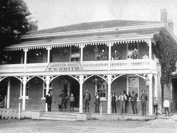
Tom Riley Park to Lambton House via Mimico Creek, Park Lawn Cemetery and the Humber River Trail
https://hikes.brucetrail.org/event/tom-riley-park-to-lambton-house-via-mimico-creek-park-lawn-cemetery-and-the-humber-river-trail/Sorry, the registration cut-off time for this hike has been reached.Not a member? Click here to join today!Hosting Club: Toronto
Category: Urban Walk
Location (Google Maps): Bloor Islington Place across from Islington Subway Station (east side)
Note the west side entrance to Islington Avenue is closed. You must use the east side entrance that will take you to Islington PlaceHike Leader(s): Andrew Proczek Click here to contact Hike Leader(s)
Pace: Moderate (3-4 km/hr)
Terrain: Level 1 (Easy – mostly on flat, well maintained trails with hard-packed surface)
Distance (km): 7 kmDescription
Join me for a short hike on familiar trails. Due to cold conditions this is an abbreviated hike. Our destination will be historic Lambton House for a 2:00 Lecture by Tim Morawetz titled, “Highlights of Canada’s Art Deco Architecture”.The Route:https://onthegomap.com/s/8ta9gmfp
- 26January 26, 2026No events
- 27January 27, 2026
9:00 Long Hike Wiley Road Short Hills NEW TIME
https://hikes.brucetrail.org/event/900-long-hike-wiley-road-short-hills-new-time-15/Sorry, the registration cut-off time for this hike has been reached.Not a member? Click here to join today!Hosting Club: Niagara
Category: Loop
Location (Google Maps):Short Hills Wiley Road Entrance
Hike Leader(s): Lynskie Click here to contact Hike Leader(s)
Pace: Brisk
Distance: 10km
Description
Explore Short Hills and the majestic side trails of Scarlett Tanager, Hemlock. Swayze Falls and Terrace. Register for each hikeBring Poles, snack, and dress for the weather
9:15 Short Hike - Short Hills Park, Pelham Rd
https://hikes.brucetrail.org/event/915-short-hike-short-hills-park-pelham-rd-38/Sorry, the registration cut-off time for this hike has been reached.Not a member? Click here to join today!Hike open to BTC Members only.
Hosting Club: Niagara
Category: Loop
Location (Google Maps): Short Hills Provincial Park, Pelham Rd entranceHike Leader(s): Debbie Demizio Click here to contact Hike Leader(s)
Pace: Medium
Terrain: Moderate
Distance: ~ 6kmsDescription
Hike the main and side trails of Short Hills Provincial Park. Please note that there are some steep hills and rocky sections, so you should have some hiking experience before joining this hike. Please bring water, hiking poles and icers, as the trail can be icy at times.Island Lake - Orangeville - CANCELLED
https://hikes.brucetrail.org/event/island-lake-orangeville-4/Sorry, the registration cut-off time for this hike has been reached.Not a member? Click here to join today!Hosting Club: Caledon Hills
Category: Tuesday Hikers
Location (Google Maps): Meet at Vicki Barron Lakeside Trail Parking.
After driving through Orangeville traffic lights on Highway 10, turn right on Hockley Rd., keep straight onto Sideroad 5, turn right on Hurontario Street to the car parking close to the lake.Hike Leader(s): Mohammad Shafiq Click here to contact Hike Leader(s)
Pace: Medium – 3 to 4 km/hour
Terrain: Easy – mostly flat and usually good footing
Distance: 10 kmDescription
Will hike around Island Lake, may take diversion into the side trail for a total of 10 km completing a loop around the lake.
For dressing take into account weather conditions, bring icers there may be snow on the trails.
Bring a warm drink and snack.
Check your email 7:00 am as the hike may be cancelled if driving conditions are hazardous.
There is optional refreshment stop after hike at Orangeville, will decide during hike.Urban Walk: Valley View Park Thornhill
https://hikes.brucetrail.org/event/urban-walk-valley-view-park-thornhill-137/Sorry, the registration cut-off time for this hike has been reached.Not a member? Click here to join today!Hosting Club: Toronto
Location (Google Maps): Parking lot is off Sycamore Drive, East of Bayview , across Starbucks plaza
Bus 91 from Finch East station stops at Sycamore station.Hike Leader(s): Mohammad Aghamiri Click here to contact Hike Leader(s)
Pace: Moderate (3-4 km/hr)
Terrain: Hilly, Level 2 (Intermediate – some hills and uneven surfaces, rocks and roots underfoot), Variable
Distance (km): 6-7 kmDescription
We will explore Valleyview and Maple View parks, and walk along German Mill Creak, in return we stop in Huntington park and have snack under beautiful shed.Although this is considered an “Urban Walk”, you can expect some hills up and down and uneven surfaces with tree roots. Please bring hiking poles, Ice cleats water and snacks.
phone number for the day of hike 289 588 6482
Oliver Creek Loop from 2nd Line
https://hikes.brucetrail.org/event/oliver-creek-loop-from-2nd-line/Sorry, the registration cut-off time for this hike has been reached.Not a member? Click here to join today!Hosting Club: Dufferin Hi-Land
Category: Tuesday Hike
Location (Google Maps): Dufferin Hi-Land, Map 20. Meet on east side of 2nd Line, 300m north of the bend from 8 Sideroad onto 2nd Line, where the Main Trail turns off of the road, heading east (Km 22.3)Hike Leader(s): Les Babbage;Inge Eckerich;Julie Daley;Tony Evangelista Click here to contact Hike Leader(s)
Pace: Leisurely
Terrain: Slippery and Steep Sections
Distance: 5.2 or 3.7 kmDescription
We will hike the Main Trail to the second intersection with Oliver Creek Side Trail, then loop back on this trail to the Main Trail. The short hike will cut off on the 2nd Line Side Trail and walk south of 2nd Line to the cars. Snowshoes or ices will likely be required. Bring water snacks and dress warmly for the weather.
Walk In Nature Series (WINS) -Beaver Springs Side Trail, Irish Block Road
https://hikes.brucetrail.org/event/walk-in-nature-series-wins-beaver-springs-side-trail-irish-block-road/Sorry, the registration cut-off time for this hike has been reached.Not a member? Click here to join today!Hosting Club: Sydenham
Category: Snowshoe Hike
Location (Google Maps): Roadside parking on the Irish Block Road, just north of Highway 26. Click on the P at this location on the Bruce Trail app. This meet location is found near km 62.4 on Map 31 of Edition 31 of the Bruce Trail Reference.
If you don’t have the Bruce Trail app, you can use Google Maps on your device to direct you to the meet location’s GPS coordinates by clicking the link “(Google Maps)” which is found right after the title Location in this description. Alternatively, copy the coordinates from here: 44.592032, -80.793507Hike Leader(s): Stewart Brown Click here to contact Hike Leader(s)
Pace: Medium: 3 to 4 km/h
Terrain: Moderate: Some hills and/or poor footing
Distance: 3.6 kmDescription
The Walk In Nature Series (WINS) consists of 2 hour hikes in the Sydenham section of the Bruce Trail that combine nature appreciation with fitness in a safe and welcoming group environment led by an experienced hike leader. Consider these hikes to be appointments with yourself in nature that promote health and fitness.On this snowshoe hike, explore the winter magic of BTC’s Beaver Springs Wetland as the trail winds through cedars and maples.
Arrive 15 min early, dress in layers with good footwear. Bring your snowshoes for sure and hiking poles may be helpful. Bring water and a snack. See you there!
- 28January 28, 2026

8:30 Niagara Winter End to End #4 Roland Road to Decew House
https://hikes.brucetrail.org/event/830-niagara-winter-end-to-end-4-roland-road-to-decew-house-3/Sorry, the registration cut-off time for this hike has been reached.Not a member? Click here to join today!Hosting Club: Niagara
Category: Car Pool
Location (Google Maps): Meet at Decew House Heritage Park and Car Pool to Short Hills Parking Lot at Roland Road.Hike Leader(s): Sam Rutherford Click here to contact Hike Leader(s)
Pace: Medium
Terrain: Moderate
Distance: 12.4 kmsDescription
We will be car pooling, Bring Icers and poles. No dogs. To earn your Niagara Winter End to End badge, it must be completed between December 21, 2025 to March 21, 2026.
Because of the potential for bad winter trail conditions we have broken this e2e into 6 hikes rather than 5
Niagara E2E Winter - 1 of 5 (Wednesdays)
https://hikes.brucetrail.org/event/niagara-e2e-winter-1-of-5-wednesdays/Sorry, the registration cut-off time for this hike has been reached.Not a member? Click here to join today!Hosting Club: Niagara, Iroquoia
Category: General Hike
Location (Google Maps): Roadside parking on Taylor Rd, across from the entrance to Woodend Conservation Area (I think we can park at the entrance to Woodend off the road) and we will shuttle to Locust Grove Picnic Area on Niagara River Parkway near Brock’s Monument 43.143241,-79.167617Hike Leader(s): Steven White Click here to contact Hike Leader(s)
Pace: Brisk – 4 to 5 km/hr, Medium – 3 to 4 km/hr
Terrain: Moderate – Some hills and/or some poor footing, Slippery and Steep Sections
Distance: 15.5 kmDescription
The Niagara E2E Winter in 5 will be Wednesdays Jan 28, Feb 4, 11, 18, 25. Hikers must register for individual hikes. Hikes are 14-18 kms and expect an average pace of 4 km/hr with snack/lunch breaks.Hikers should be prepared for the season – layered clothing, hiking boots, icers, snowshoes (if we get fresh snowfall), poles, water, snacks/lunch, first aid kit.
Hikers should be prepared to share their cars for shuttling – to be shared evenly.
If we encounter unsafe hiking or driving conditions, I will cancel/re-schedule the hike the day before. If you are unable to join us on the day of the hike, please text me at 289-242-9415

Limehouse
https://hikes.brucetrail.org/event/limehouse/Sorry, the registration cut-off time for this hike has been reached.Not a member? Click here to join today!Hosting Club: Iroquoia
Category: General Hike
Location (Google Maps): Limehouse Conservation AreaHike Leader(s): Karen Bergmann Click here to contact Hike Leader(s)
Pace: Medium – 3 to 4 km/hr
Terrain: Easy – Mostly flat and usually good footing
Distance: 7 kmsDescription
The main trail was taken off the road north of Limehouse and put through a lovely forest from 6th Line. A fairly easy hike, with rocks and roots but no major hills. We will meet in the parking lot at Limehouse at 9:15 am and carpool to 6th Line, hiking back along the main Bruce Trail into the Conservation Area and passing the iconic stone arch, turning onto the Black Creek Side Trail to the main trail. This is a great hike for beginners and those who are exploring the dynamic of a group hike.Winter Wednesday Walkers - Hogg's Falls Side & Main Trails
https://hikes.brucetrail.org/event/winter-wednesday-walkers-hoggs-falls-side-main-trails-3/Sorry, the registration cut-off time for this hike has been reached.Not a member? Click here to join today!Hosting Club: Beaver Valley
Location (Google Maps): Meet in the Hogg’s Falls parking lot, km 65.2, Map 26, Edition 31. If the parking lot is not plowed we will park on the shoulder of the road, west side, just south of the parking lot entrance.
Hike Leader(s): Glenda Collings Click here to contact the hike leader.
Pace: Medium
Terrain: Some steep sections
Length of Hike: Approx. 6 kmDescription
We will hike both the Uplands Meadow and Upper Beaver Valley Side Trails plus sections of the main trail and view Hogg’s Falls in its winter glory. On winter hikes we may encounter bare ground, light snow, deep snow, or ice. Please bring snowshoes and icers to our Winter Wednesday Walkers outings. Wear appropriate clothing for the weather plus water and a snack.COVID-19 Precautions Before, During and After your Hike
- Each hiker joining a Bruce Trail Club organized hike must perform a self-screening check before hiking.
Find Ontario’s self-assessment tool here: https://covid-19.ontario.ca/self-assessment/ - If you are experiencing COVID-19 symptoms, stay home.
Other Guidelines
- Arrive 15 minutes before the start of the hike.
- Wear sturdy footwear and appropriate attire for the weather and the terrain.
Hiking poles are a good idea in any season, especially if the terrain is rocky or slippery. In winter, snowshoes or icers/crampons are needed when conditions dictate.
Wearing appropriate clothing and footwear prevents injuries and shows consideration for a safe and positive group hiking experience. - Always carry I.D. and your health card.
- Bring sufficient water and snacks (or lunch if indicated). A minimum of 1L of water is recommended on all hikes, and 3L is recommended for long, challenging hikes in the heat of the summer.
- Bring sunscreen and insect repellent (for spring and summer hikes).
- Bring your own first aid kit.
- Please leave dogs at home.

Lollipop Hike CANCELLED
https://hikes.brucetrail.org/event/lollipop-hike-2/Sorry, the registration cut-off time for this hike has been reached.Not a member? Click here to join today!Hosting Club: Iroquoia
Category: Good Companions
Location (Google Maps): Halton Agreement ForestHike Leader(s): Anne Armstrong Click here to contact Hike Leader(s)
Pace: Leisurely – 3km/hr or less
Terrain: Easy – Mostly flat and usually good footing, Moderate – Some hills and/or some poor footing
Distance: Approx. 8 km.Description
Come explore the many trails of this extensive forest. We will use a combination of hiking and biking trails. Our route will be mostly flat with one rocky section. This is basically and “in and our” with a loop at the top, hence the name “lollipop”. If Mother Nature is kind we should have wonderful winter views. Bring water, a snack and icers. I recommend poles for the rocky section. I will send out an email the day before to give you my cell phone number in the event that you need to cancel the night before or morning of. Just text me. - Each hiker joining a Bruce Trail Club organized hike must perform a self-screening check before hiking.
- 29January 29, 2026

Frosty Five Weekday - Hike Four
https://hikes.brucetrail.org/event/frosty-five-weekday-hike-four/Sorry, the registration cut-off time for this hike has been reached.Not a member? Click here to join today!Hosting Club: Caledon Hills
Category: General
Location (Google Maps): Meet at roadside parking on Escarpment Road, between St. Andrew’s and Mountainview Roads, 43.884912, -79.920313.Directions: From Hwy #10 turn east onto Olde Baseline Road for 5.5 km. Turn north/left on St. Andrew’s Road for 6.3 km. Turn right on Escarpment Sideroad for 800 metres.
Hike Leader(s): Sandy Green Click here to contact Hike Leader(s)
Pace: Medium – 3 to 4 km/hour
Terrain: Moderate – some hills and/or some poor footing
Distance: 12 kmDescription
Beat the winter blues! Register individually for one, a few, or all of the Frosty Five Blues hikes. Participants who complete all five hikes are eligible to receive a CHBTC Winter badge and a Sideways badge on the final hike. Hike Four explores parts of the main Trail, Paris Moraine ST, and Meltwater ST. Bring your choice of hydration and snacks. Hiking boots and icers/crampons are required. See Thursday, February 5 for details about the final hike in the series. (Note: If you wish to purchase badges, the cost of each badge is $10.00 for BTC members and $15.00 for non-members.) Everyone is welcome!9:00 am Long Hike Sho' aríshon Park, Jordan Hallow
https://hikes.brucetrail.org/event/900-am-long-hike-sho-arishon-park-jordan-hallow/Sorry, the registration cut-off time for this hike has been reached.Not a member? Click here to join today!Hosting Club: Niagara
Category: In and Out
Location (Google Maps): Sho’ aríshon Park, Jordan HallowHike Leader(s): Lauren Doig Click here to contact Hike Leader(s)
Pace: Brisk
Terrain: Moderate
Distance: 10 kmDescription
Hike around the Ball’s Falls area.Dress for the weather. Bring icers, poles, water.
Hiking around Jordan
https://hikes.brucetrail.org/event/hiking-around-jordan-44/Sorry, the registration cut-off time for this hike has been reached.Not a member? Click here to join today!Hosting Club: Niagara
Location (Google Maps): Glen Road Parking Lot
3640 Glen Road, Jordan LOR 1SOHike Leader(s): Bill Russell Click here to contact Hike Leader(s)
Pace: Medium
Terrain: Moderate
Distance: 7 kmDescription
This hike has been cancelled due to cold temperatures.Urban Walk: Valley View Park Thornhill
https://hikes.brucetrail.org/event/urban-walk-valley-view-park-thornhill-138/Sorry, the registration cut-off time for this hike has been reached.Not a member? Click here to join today!Hosting Club: Toronto
Location (Google Maps): Parking lot is off Sycamore Drive, East of Bayview , across Starbucks plaza
Bus #91 from Finch Regional Bus Terminal stops at Sycamore Drive.Hike Leader(s): Mohammad Aghamiri Click here to contact Hike Leader(s)
Pace: Moderate (3-4 km/hr)
Terrain: Hilly, Level 2 (Intermediate – some hills and uneven surfaces, rocks and roots underfoot), Variable
Distance (km): 6-7 kmDescription
We will explore Valleyview and Maple View parks, and walk along German Mill Creak, in return we stop in Huntington park and have snack under beautiful shed.Although this is considered an “Urban Walk”, you can expect some hills up and down and uneven surfaces with tree roots. Please bring hiking poles, Ice cleats water and snacks.
phone number for the day of hike 289 588 6482
- 30January 30, 2026
Brisk Fridays - Blantyre to near Walter's Falls
https://hikes.brucetrail.org/event/brisk-fridays-blantyre-to-near-walters-falls/Sorry, the registration cut-off time for this hike has been reached.Not a member? Click here to join today!Hosting Club: Sydenham
Category: Snowshoe Hike
Location (Google Maps): For directions to parking, click on the link after the title Location of this description. Or use the GPS coordinates: 44.49646, -80.72154. Roadside parking on the Holland-Sydenham Townline just 200 metres west of Grey Road 29. Found in the Bruce Trail Reference Edition 31 on Map 29Hike Leader(s): Stewart Brown Click here to contact Hike Leader(s)
Pace: Brisk: 4 to 5 km/h
Terrain: Strenuous: Hilly with steep climbs and some poor footing., There are crevices or holes which may be hidden by layers of snow. Hike with extreme caution., There might be icy and slippery sections.
Distance: 10 kmDescription
This strenuous snowshoe hike is mostly in the Rocklyn Creek Management Area, through its pristine snow-laden forests, atop its rocky crags and alongside its spring-fed creek. Our actual pace will be between 2.5 and 3.0 km/h which requires an effort that matches what would be required on a summer hike of a brisk pace of 4-5 km/h. After meeting, we will shuttle to Blantyre and hike back to our vehicles. Be prepared for a good workout as we traverse steep climps and slippery slopes with both exposed and hidden rocks. Registrants will receive an email the day before the hike with an update of trail conditions and what to bring. Snowshoeing 10 km in deep snow is no easy feat, but if you’re up to the challenge, you are most welcome!
9:00 am Niagara-on-the-Lake Tour
https://hikes.brucetrail.org/event/900-am-niagara-on-the-lake-tour-54/Sorry, the registration cut-off time for this hike has been reached.Not a member? Click here to join today!Hosting Club: Niagara
Category: Urban
Location (Google Maps):Veterans Memorial Park, park just outside the park on King Street
Hike Leader(s): Robin Garrett Click here to contact Hike Leader(s)
Pace: Medium
Terrain: Easy
Distance: 6-7 kmDescription
Each Friday we will explore different neighbourhoods, trails and parkland throughout Historic Niagara-on-the-Lake.Moderate pace with some weeks entirely on sidewalks and roads while others may include a mix of trails and paved pathways. Great way to build up endurance for longer more strenuous hikes.
Prepare for cooler windy conditions on open parkland and along Lake Ontario and Niagara River trails.
Plan to stay for conversation and a warm cup of coffee or tea at Sweets & Swirls, Community Centre, Niagara Stone Road, NOTL
- 31January 31, 2026
Coach Trip: Arrowhead Provincial Park
https://hikes.brucetrail.org/event/coach-trip-arrowhead-provincial-park-3/Sorry, the registration cut-off time for this hike has been reached.Not a member? Click here to join today!Trip Information
Departure Time: 08:00
Return to City Time: 18:45
Departure Point: York Mills Bus PickupTrip Activities
X-Country Skiing ($0.01)
Snowshoeing ($0.01)
Optional Items
P/U @ Hwy 400 & Major Mac ($0.01)Hosting Club: Toronto
Category: Coach Trips
Location (Google Maps): Arrowhead Provincial ParkHike Leader(s): Tim Wainwright, Robin Crombie, Tom Swales, Janet McColeman Click here to contact Hike Leader(s)
Pace: Moderate (3-4 km/hr)
Terrain: Level 2 (Intermediate – some hills and uneven surfaces, rocks and roots underfoot), RockyDescription
No trail fees at Arrowhead. Registration cost includes park admission.Bus departs 10 York Mills Rd at 8 AM and HWY 400 and Major Mackenzie Dr Park and Ride at 8:20 AM. If you wish to be picked up at HWY 400 and Major Mac, select that option when you register. Please arrive 15 minutes before departure.
Join us for an awesome day of winter fun in Arrowhead Provincial Park. For information about trail conditions visit: https://www.ontarioparks.com/snowreport/detail/arrowhead. For information about the park visit: https://www.ontarioparks.com/park/arrowhead.
Join Janet and Leonora for a fun guided hike, break a new trail with Tim and Robin, or enjoy self-guided skiing on trails groomed for classic and skate skiing. After skiing or snowshoeing spend some time ice skating (if open) in the forest.
Ski, skate and snowshoe rentals available.
There are no food services in the park. Pack water/tea and lunch.
We will leave the park at 4 PM. Bring a snack (finger food) to share on the bus ride home.
Policy for running this trip: To run this trip we need 40 registrants 8 days in advance. We may cancel the trip on short notice if there is substantial risk of trail or resort closure due to major weather warnings. If there is enough snow to ski and conditions are marginal or better, we will go. Marginal conditions mean not ideal skiing conditions. For example, wet snow, a thin bumpy base, or some icy patches. If TBTC cancels the trip, we will refund your coach fare. No refund if you cancel.
Bethesda Trail Richmond Hill
https://hikes.brucetrail.org/event/car-hike-7258-leslie-st-7272-thornhill-on-l3t-6l6/Sorry, the registration cut-off time for this hike has been reached.Not a member? Click here to join today!Hosting Club: Toronto
Category: Car Hike
Location (Google Maps): Oak Ridges Corridor, Bethesda Trail Head Parking Lot, Bethesda Side Road, Richmond Hill, OntarioHike Leader(s): Mohammad Aghamiri Click here to contact Hike Leader(s)
Pace: Moderate (3-4 km/hr)
Terrain: Level 2 (Intermediate – some hills and uneven surfaces, rocks and roots underfoot), Variable
Distance (km): 12-14 kmDescription
Join us to explore the trails of York Regional Forest and the Oak Ridges Corridor at Jefferson Forest and Bond lake,From parking lot we hike thought Jefferson forest and continue to Bond Lake and have snack beside the lake and return to parking around 13 to 13.30
Please bring your ice cleats, hiking poles are recommended
phone number for the day of hike 289 588 6482
Please bring hiking poles, proper closing and shoes and lots of water and smile.
For the day of hike phone number 289 588 6482
Mountainview Conservation Area towards Grimsby
https://hikes.brucetrail.org/event/mountainview-conservation-area-towards-grimsby/Sorry, the registration cut-off time for this hike has been reached.Not a member? Click here to join today!Hosting Club: Niagara
Category: In and Out
Location (Google Maps): Mountainview Conservation Area Parking lotHike Leader(s): Lauren Doig Click here to contact Hike Leader(s)
Pace: Medium
Terrain: Strenuous
Distance: 15- 18 kmDescription
Meet at Mountainview Conservation Area Parking lot and head towards Grimsby. We’ll see how far we can get depending on the conditions. Dress for the weather. Bring poles, icers, water and a snack.Maybe a stop at Fielding’s after the hike to check out the spheres and a snack?

Car Hike: Jefferson Forest (Richmond Hill)
https://hikes.brucetrail.org/event/car-hike-jefferson-forest-richmond-hill-2/Sorry, the registration cut-off time for this hike has been reached.Not a member? Click here to join today!Hosting Club: Toronto
Category: Car Hike
Location (Google Maps):1245 Bethesda Side Rd, Richmond Hill, ON L4E 1A2 ( Bethesda Trail Head Parking lot)
Hike Leader(s): Amir Alemohammad Click here to contact Hike Leader(s)
Pace: Moderate (3-4 km/hr)
Terrain: Flat, Hilly, Level 2 (Intermediate – some hills and uneven surfaces, rocks and roots underfoot), Variable
Distance (km): 10-11 kmDescription
Join us for a wonderful winter hike in Jefferson Forest. Hiking boots, icers mandatory, poles recommended, bring at least two litters of water and snacks, dress according to the winter weather conditions. Parking is free and please avoid parking along the road. Difficulty Level: 2 (Moderate).Please arrive @8:45AM for start of 9:00AM.
This is a joint hike with the Oak Ridges Trail Association (ORTA).
Hilton Falls (reservation required)
https://hikes.brucetrail.org/event/kelso-summit-reservation-required-if-the-park-is-open/Sorry, the registration cut-off time for this hike has been reached.Not a member? Click here to join today!Hosting Club: Iroquoia
Category: General Hike
Location (Google Maps): Hilton Falls parking lot at 9:15 am (reservation required)Hike Leader(s): Karen Bergmann Click here to contact Hike Leader(s)
Pace: Medium – 3 to 4 km/hr
Terrain: Moderate – Some hills and/or some poor footing
Distance: 8 kmsDescription
Meet in the parking lot at Hilton Falls at 9:15 am. We will hike to the Falls and around a few of the hiking trails. Reserve your time at conservationhalton.ca.**Cancelled (new date TBD) Nottawasaga Lookout Extended Loop
https://hikes.brucetrail.org/event/nottawasaga-lookout-extended-loop/Sorry, the registration cut-off time for this hike has been reached.Not a member? Click here to join today!Hosting Club: Blue Mountains
Category: Cancelled
Location (Google Maps): Tim Horton’s, First Street CollingwoodHike Leader(s): Claire Pearson Click here to contact Hike Leader(s)
Pace: Leisurely – 3 km/hr. or less
Terrain: Moderate – Some hills and/or some poor footing
Distance: 4 kmDescription
***This hike is postponed due to cold temperatures. A new date is still to be determined.***Enjoy a winter morning of snowshoeing through the forest and taking in amazing views overlooking the Georgian Bay area. We will begin our extended loop hike of the Bruce Trail through the Nottawasaga Lookout Provincial Nature Reserve at km 42.4 (map 23). We will walk the northern part of the loop and continue on until we reach the opening overlooking a pond (point 44.407, -80.249 on the Bruce Trail App). We will turn around and head back, taking the southern part of the loop and returning to our cars. The total walking distance will be ~4km.
Winter Badge Series Hike #3 of 4
https://hikes.brucetrail.org/event/winter-badge-series-hike-3-of-4/Sorry, the registration cut-off time for this hike has been reached.Not a member? Click here to join today!Hosting Club: Dufferin Hi-Land
Category: General Hike
Location (Google Maps): Dufferin Hi-Land Map 19 Ed.31 Km 7.8Hike Leader(s): Bryan and Carol Foley Click here to contact Hike Leader(s)
Pace: Leisurely
Terrain: Dependent on Conditions, Moderate, Slippery Sections Likely
Distance: 6 kmsDescription
Dufferin Hi-Land, Map 19. Mono Cliffs Provincial Park. Meet at south end of 1st Line EHS, Mono (Km 7.9), south of 25 Sideroad.
Directions ; Coming north on Hwy 10 turn right on 25 Sideroad ( approx. 14 km north of Orangeville ) then right on 1st Line EHS follow to end. NOTE Parking is very limited if you can car pool with someone that would be a great help BE CAREFUL OF THE DITCHES! Bring water, Headlamp, Icers, Snowshoes, Dress for the conditions