Hike Schedule
Join us for a hike! Registration required:
All hikes available to BTC members. Some hikes are open to non-members.
TIP: The calendar view displays up to 7 hikes on a day, but often there are more. Click “More events” to see them all.
Categories
- 03August 3, 2025

Steeltown Stomp Practice Session #5 of 10
https://hikes.brucetrail.org/event/steeltown-stomp-practise-session-1-of-10-5/Sorry, the registration cut-off time for this hike has been reached.Not a member? Click here to join today!Hosting Club: Iroquoia
Location (Google Maps): Meet at the Chedoke Golf Club parking lot
Hike Leader(s): Ruth Moffatt Click here to contact Hike Leader(s)
Pace: Brisk – 4 to 5 km/hr, Medium – 3 to 4 km/hr
Terrain: Strenuous – Hilly with steep climbs and some poor footing
Distance: VariesDescription
Is the Steeltown Stomp on your bucket list! Come join us! For anyone who has done stair climbing workouts, you will know what calf pain is like, especially when you first start. Want to get in shape of the Steeltown Stomp on October 4, 2025? Practise with us! We will start off easy and gradually build up our strength and stamina over the course of the summer. Climbing Chedoke staircase will be combined with a hike on most days. We will use both Chedoke and Dundurn Stairs as our practise stairs and buildup to at least 2,000 steps.Bring a reusable water bottle (there are fountains at the bottom of both Chedoke and Dundurn) and any snacks you may like. Pace will be moderate, but steady to begin. We will start with a warm up hike and finish with a cool down stretch. Post stomp coffee is optional .
It’ll be fun and will lessen the pain on the day of the event, promise!
Look for the other 9 dates on the schedule.

Car Hike: Exploring Uxbridge Trails (Wilder Forest, Walker Woods, and Glen Major Forest)
https://hikes.brucetrail.org/event/car-hike-exploring-uxbridge-trails-wilder-forest-walker-woods-and-glen-major-forest-14/Sorry, the registration cut-off time for this hike has been reached.Not a member? Click here to join today!Hosting Club: Toronto
Location (Google Maps):
2499 Brock Rd, Uxbridge, ON L9P 1R4. We will meet at the East Duffins Headwaters parking lot at the WILDER FOREST trail head. As soon as you got off the Brock Road, passing the horse back riding facility, there is a free designated parking lot 70 meters down the lane to your right. It includes a sign board for East Duffins Headwaters with a map of the trails. Please do not park on the lane or in the horse back riding property.
Hike Leader(s): Amir Alemohammad Click here to contact Hike Leader(s)
Pace: Moderate (3-4 km/hr)
Terrain: Flat, Hilly, Level 2 (Intermediate – some hills and uneven surfaces, rocks and roots underfoot), Variable
Distance: Approx.15-16 KmDescription
Join us for a delightful hike in Uxbridge, as we explore Wilder Forest, Walker Woods, and Glen Major Forest on a scenic loop starting from Brock Road. We’ll pass Concession Road 6, heading west and back, while also venturing onto several side trails for even more stunning views.What to Expect:
•Beautiful scenic views and lookouts facing south
•A mix of hilly and flat terrain
•Frequent 2-minute breaks for hydration and photos, with a 10-20 minute lunch/snack stop
•Stay on designated trails at all time
What to Bring and Wear:
•Hiking Boots and poles (recommended) and be prepared for the bugs
•At least 2 liters of water
•Your favorite snacks and lunch (pack your own refreshments for an outdoor meal)
•Dress according to variable weather conditions!
Important Details:
•Stay on the designated trails
•Be prepared for the elements and enjoy the adventure!
Looking forward to seeing you on the trail!
Don’t forget your camera and a smile as we explore the beauty of the Uxbridge trails!
This is a joint hike with the Oak Ridges Trail Association (ORTA).

Scotsdale Farm Great Esker
https://hikes.brucetrail.org/event/scotsdale-farm-great-esker/Sorry, the registration cut-off time for this hike has been reached.Not a member? Click here to join today!Hosting Club: Iroquoia
Category: General Hike
Location (Google Maps): Scotsdale Farm 8th Line parking lotHike Leader(s): Karen Bergmann Click here to contact Hike Leader(s)
Pace: Medium – 3 to 4 km/hr
Terrain: Moderate – Some hills and/or some poor footing
Distance: 10 kmsDescription
Meet in the parking lot off 8 Line at 9:15 am. We’ll hike the Maureen Smith Side Trail to the main trail and around the Great Esker Side Trail, back to the main trail and the Bennet Heritage Side Trail for a total of about 10 kms. There are some hills. Bring bug spray/bug net, water and a snack.Urban Walk: Don Mills Trail/Wilket Creek/ET Seton Park to Leaside
https://hikes.brucetrail.org/event/urban-walk-don-mills-trail-wilket-creek-et-seton-park-to-leaside/Sorry, the registration cut-off time for this hike has been reached.Not a member? Click here to join today!Hosting Club: Toronto
Category: Urban Walk
Location (Google Maps): Meet on the Southeast corner of Bayview and York Mills in front of the arena (a short ride on the York Mills 95 Bus from York Mills Station)Hike Leader(s): Tom Swales Click here to contact Hike Leader(s)
Pace: Moderate (3-4 km/hr)
Terrain: Level 2 (Intermediate – some hills and uneven surfaces, rocks and roots underfoot), Variable
Distance: 12 kmDescription
This weekend marks the 10th anniversary of my starting to lead hikes for the TBTC. Today’s hike will follow my original route south through Windsfield Farm Park, on Banbury Road, lunch at Edwards Gardens, then south on Wilket Creek. From the West Don we will make our way to Leaside and Corks Beer & Wine Bar in the Longo’s store. Non-alcoholic options are available. The route is mostly flat but there will be a small hill to exit from the valley at the end. I would also like to use this hike to pay tribute to everyone who has supported my hikes which led to my current role and impact on the hiking program.Exploring Sydenham Hikes #27 West Rocks and #28 Merle Gunby Loops
https://hikes.brucetrail.org/event/exploring-sydenham-hikes-27-west-rocks-and-28-merle-gunby-loops/Sorry, the registration cut-off time for this hike has been reached.Not a member? Click here to join today!Hosting Club: Sydenham
Category: General Hike
Location (Google Maps): Roaside parking on Owen Sound 6th Ave. W. just south of 7th St. W.Hike Leader(s): Bill Snel Click here to contact Hike Leader(s)
Pace: Leisurely: 3 km/h or less
Terrain: Moderate: Some hills and/or poor footing, Strenuous: Hilly with steep climbs and some poor footing.
Distance: 4 kmDescription
We will do a short 600 m loop hike on the west rocks using the 7th St. W. and Chalmers Quarry side trails. There is no secret on this short loop. We will then each drive to the Grey Bruce Tourist Information Office parking lot at Springmount and do a 2.5 km loop of the Merle Gunby Side trail including a look at Jones Falls when we get near it. This loop has one secret. If you do not have a book and would like one ($30) let me know by using the “Contact hike leader” link. - 04August 4, 2025
8:30 am Hydro Hill Training
https://hikes.brucetrail.org/event/830-am-hydro-hill-training-4/Sorry, the registration cut-off time for this hike has been reached.Not a member? Click here to join today!Hosting Club: Niagara
Category: In and Out
Location (Google Maps):Lockhart Drive, St Catharines, by the large yellow swing gate.
Hike Leader(s): Suzanne Gourluck Click here to contact Hike Leader(s)
Pace: Brisk
Terrain: Strenuous
Distance: 6 kmsDescription
This challenging “hike” is intended for those wishing to train for future challenging hikes. Choose your own pace to go up and down the moderately steep hill over 60 minutes. The terrain is a hard packed gravel surface. Feel free to bring light weights to increase the intensity of your training. Bring water, hiking poles, snack and dress for the weather.Glen Road to Ball's Falls and Rainforth side trail YOUTH 12+ WELCOME
https://hikes.brucetrail.org/event/glen-road-to-balls-falls-and-rainforth-side-trail-youth-12-welcome/Sorry, the registration cut-off time for this hike has been reached.Not a member? Click here to join today!Hosting Club: Niagara
Category: Youth Hike
Location (Google Maps): Glen Road parking area 3640 Glen Rd, Jordan Station, ON L0R 1S0Hike Leader(s): Erin Lyttle Click here to contact Hike Leader(s)
Pace: Leisurely
Terrain: Moderate
Distance: 5.6 kmDescription
We will be starting at Glen road and head to Ball’s Falls historical village (including the massive stairway up the escarpment!) we will check out Dug out Pond and see if any turtles or frogs are hanging out, then back down the stairs and back to Glen road. For those not tired yet, we’ll cross the street and follow the Bruce to 17th, turn around and take the Jim Rainforth side trail back to the parking lot.This is an age 12+ hike. A responsible adult must accompany youth 12-18 in a max ratio of 2 youth per adult. This hike has little road and lots of shade. Glen road the Ball’s Falls is quite rocky and the stairs up to the falls are long and steep. Waivers must be completed for everyone in attendance (adults and youth). Bug spray, sunscreen, water and a snack are encouraged. Must wear appropriate footwear. For hikers 15 and under interested in earning a youth badge, they will be available on the hike for $6 please bring cash.
The Young Trail Blazer Badge requires the completion of one hike (at least 3km in length) conducted on the Niagara Bruce Trail. Hikes can be completed with the club on an official scheduled hike or with family on their own.
To earn the Young Nature Blazers Badge you must complete a 90 minute hike on the Niagara Bruce Trail. Afterwards, chat with the hike leader describing how you used one or more of your five senses on the hike – what did you see, touch, taste, smell or hear during your hike?
- 05August 5, 2025
8:00 Long Hike Wiley Road Short Hills
https://hikes.brucetrail.org/event/800-long-hike-wiley-road-short-hills-7/Sorry, the registration cut-off time for this hike has been reached.Not a member? Click here to join today!Hosting Club: Niagara
Location (Google Maps):
Short Hills Wiley Road Entrance
Pace: Medium
Terrain: Moderate
: 10kmDescription
Explore Short Hills and the majestic side trails of Scarlett Tanager, Hemlock. Swayze Falls and Terrace. Register for each hikeBring Poles, Sun Screen Bug Spray, snack, and dress for the weather
Rattlesnake Point - Crawford Lake Loop Hike
https://hikes.brucetrail.org/event/rattlesnake-point-crawford-lake-loop-hike/Sorry, the registration cut-off time for this hike has been reached.Not a member? Click here to join today!Hosting Club: Iroquoia
Category: General Hike
Location (Google Maps): Rattlesnake Pont Conservation AreaHike Leader(s): Pati Greenwood, Jeff Dowsett Click here to contact Hike Leader(s)
Terrain: Moderate – Some hills and/or some poor footing
Distance: 15 kmDescription
This will be a loop hike starting and ending on the Rattlesnake Point Side Trail. We will hike along the main trail as well as BT side trails to Crawford Lake, we hike the main trail loop at Crawford Lake and head back through the Nottawasaga Canyon. This route will feature a few hills and some uneven, rocky terrain.August weather can be hot, muggy and buggy! Dress for the weather, keeping in mind that insects, including ticks, will be out in full force. Take appropriate precautions to avoid insect bites, including using repellent and wearing clothing that covers the legs and arms. Hiking boots are required and poles and recommended. Bring plenty of water and/or other hydration and a snack.
Parking reservations must be obtained from Conservation Halton (https://www.conservationhalton.ca/) . Please arrive at 8:15 am as we will leave promptly at 8:30 am.
Urban Walk: Valley View Park Thornhill
https://hikes.brucetrail.org/event/urban-walk-valley-view-park-thornhill-90/Sorry, the registration cut-off time for this hike has been reached.Not a member? Click here to join today!Hosting Club: Toronto
Location (Google Maps): Parking lot is off Sycamore Drive East of Bayview , across Starbucks plaza
Bus 91 from Finch east station stops at Sycamore station.Hike Leader(s): Mohammad Aghamiri Click here to contact Hike Leader(s)
Pace: Moderate (3-4 km/hr)
Terrain: Hilly, Level 2 (Intermediate – some hills and uneven surfaces, rocks and roots underfoot), Variable
Distance: 6-7 kmDescription
We will explore Valleyview and Maple View parks, and walk along German Mill Creak, in return we stop in Huntington park and have snack under beautiful shed ,Even it is considered Urban walk, it is urban hike as we have some up and down hills and tree roots, please bring your hiking poles, water and snacks,
phone number for the day of hike 289 588 6482
9:15 Short hike, Pelham Road, Short Hills
https://hikes.brucetrail.org/event/915-short-hike-pelham-road-short-hills-11/Sorry, the registration cut-off time for this hike has been reached.Not a member? Click here to join today!Hosting Club: Niagara
Category: Loop
Location (Google Maps): Pelham Road entrance, Short Hills Provincial ParkHike Leader(s): janet davey Click here to contact Hike Leader(s)
Pace: Medium
Terrain: Moderate
Distance: 6 kmsDescription
Hike the main and sidetrails in Shorthills Provincial Park. Please wear hiking boots, bring water and insect repellant. Check yourself for ticks following the hike.Speyside Loops
https://hikes.brucetrail.org/event/speyside-loops/Sorry, the registration cut-off time for this hike has been reached.Not a member? Click here to join today!Hosting Club: Caledon Hills
Category: Tuesday Hikers
Location (Google Maps): 17 Sideroad Side Trail parking lot
From HWY 401 in Milton, take Road 25 north approx. 9.5 km, turn right on 17 Sideroad
Follow to the dead end.Hike Leader(s): Jerry Bakker Click here to contact Hike Leader(s)
Pace: Medium – 3 to 4 km/hour
Terrain: Moderate – some hills and/or some poor footing
Distance: 14 kmDescription
We are hiking the Speyside loops which include 1 km of road walking on the 4th line.We will stop for lunch on the trail and based upon how we are feeling, decide if we will hike 3, 4 or 5 of the loops.
It will be approximately 14 km and take 4 hrs if we hike 5 loops.
There will be a lot of rocks but no big climbs.
- 06August 6, 2025
Full Moon Evening Hike followed by refreshments at the Hike Leader`s Home
https://hikes.brucetrail.org/event/full-moon-evening-hike-followed-by-refreshments-at-the-hike-leaders-home/Sorry, the registration cut-off time for this hike has been reached.Not a member? Click here to join today!Hosting Club: Sydenham
Category: An evening walk.
Location (Google Maps): Meet at the municipal parking lot by the river on the west side of 1st Ave E between 7th St E and 8th St E in Owen SoundHike Leader(s): Harriet Nixon
Pace: Brisk: 4 to 5 km/h
Terrain: Moderate: Some hills and/or poor footing
Distance: Approx 6 kmDescription
Join us for a brisk evening hike during the Sturgeon Full Moon exploring Owen Sound paths and neighbourhoods. Hikers are invited to the Hike Leader`s home for refreshments following the hike. There is no need to show up 15 minutes early for this hike, but we will leave promptly at 7:00 pm. - 07August 7, 2025
8:00 am Long Hike Cave Spring Conservation Area
https://hikes.brucetrail.org/event/800-am-long-hike-cave-spring-conservation-area-6/Sorry, the registration cut-off time for this hike has been reached.Not a member? Click here to join today!Hosting Club: Niagara
Location (Google Maps):
Cave Spring Conservation Area
Pace: Medium
Terrain: Moderate
: 10kDescription
This will be our permanent Thursday Location until Bridge repairs complete. From Cave Spring Conservation Area explore the trail network on the escarpment towards Kinsman Park and Moyer Road.You must register for each hike. Bring Poles, snack bug spray, sunscreen and a drink. Dress for the weather
Mono Cliffs Provincial Park Loops
https://hikes.brucetrail.org/event/mono-cliffs-provincial-park-loops/Sorry, the registration cut-off time for this hike has been reached.Not a member? Click here to join today!Hosting Club: Iroquoia
Category: General Hike
Location (Google Maps): Mono Community Centre Parking LotHike Leader(s): Pati Greenwood, Jeff Dowsett Click here to contact Hike Leader(s)
Pace: Medium – 3 to 4 km/hr
Terrain: Moderate – Some hills and/or some poor footing
Distance: 15 KmDescription
We will hike through the Mono Cliffs Provincial Park on the main Bruce Trail and several side trails. Footing should be good for most of the hike, with a few areas with exposed roots, there are a few steep hills on the route.August weather can be hot, muggy and buggy! Dress for the weather conditions, keeping in mind that insects, including ticks, will be active. Take appropriate precautions to avoid insect bite, including using repellent and wearing clothing that covers the legs and arms. Hiking boots are required and poles are recommended.
Bring patently of water / and/or other hydration and snacks.
Park in the gravel lot at the Mono Community Centre, Mono Centre Road (County Road 8). Please arrive by 8:15 am as we will leave promptly at 8:30 am.
Urban Walk: Valley View Park Thornhill
https://hikes.brucetrail.org/event/urban-walk-valley-view-park-thornhill-91/Sorry, the registration cut-off time for this hike has been reached.Not a member? Click here to join today!Hosting Club: Toronto
Location (Google Maps): Parking lot is off Sycamore Drive East of Bayview , across Starbucks plaza
Bus 91 from Finch east station stops at Sycamore station.Hike Leader(s): Mohammad Aghamiri Click here to contact Hike Leader(s)
Pace: Moderate (3-4 km/hr)
Terrain: Hilly, Level 2 (Intermediate – some hills and uneven surfaces, rocks and roots underfoot), Variable
Distance: 6-7 kmDescription
We will explore Valleyview and Maple View parks, and walk along German Mill Creak, in return we stop in Huntington park and have snack under beautiful shed ,Even it is considered Urban walk, it is urban hike as we have some up and down hills and tree roots, please bring your hiking poles, water and snacks,
phone number for the day of hike 289 588 6482
Hiking in and around Jordan
https://hikes.brucetrail.org/event/hiking-in-and-around-jordan-5/Sorry, the registration cut-off time for this hike has been reached.Not a member? Click here to join today!Hosting Club: Niagara
Category: Hike
Location (Google Maps): Glen Road, JordanHike Leader(s): Bill Russell Click here to contact Hike Leader(s)
Pace: Medium
Terrain: Moderate
Distance: 7 kmDescription
Hiking in and around Jordan including Jim Rainforth Trail, Bailey Bridge and Balls Falls.
The Fascinating World of Butterflies and More
https://hikes.brucetrail.org/event/the-fascinating-world-of-butterflies-and-more/Sorry, the registration cut-off time for this hike has been reached.Not a member? Click here to join today!Hosting Club: Caledon Hills
Category: Nature Walks
Location (Google Maps): Riverside Woods Nature Reserve 713377 1st Line EHS MonoHike Leader(s): Gary Hall & Richard Smythe Click here to contact Hike Leader(s)
Pace: Leisurely – 3 km/hour or less
Terrain: Easy – mostly flat and usually good footing
Distance: 3 kmDescription
Discover the fascinating world of butterflies, dragonflies, damselflies and more on this leisurely stroll through the Riverside Woods Nature Reserve. We’ll attempt to find as many species as we can and learn how to record their location using iNaturalist. The following apps will assist with your learning: iNaturalist, Seek and Merlin. Dress for the weather and bring water, snacks, insect repellant, sun screen, binoculars and camera.Car Hike: Toronto E2E (4 of 4)
https://hikes.brucetrail.org/event/car-hike-toronto-e2e-4-of-4/Sorry, the registration cut-off time for this hike has been reached.Not a member? Click here to join today!Hosting Club: Toronto
Category: Car Hike
Location (Google Maps): Chinguacousy Rd, north of Olde Baseline Rd. (Map 14, 2.8k marker, Edition 31)Hike Leader(s): David Rowney Click here to contact Hike Leader(s)
Pace: Moderate (3-4 km/hr)
Terrain: Level 2 (Intermediate – some hills and uneven surfaces, rocks and roots underfoot), Variable
Distance: 14.3kDescription
This is a summer-time End-to-End hike to complete the Toronto section of the Bruce Trail in 4 hikes.This 3rd hike of the series will take us from the the Walking Fern ST on 10th Line, to the end of the Toronto Section, continuing through the Badlands, to 2.8k into the Caledon section. As with previous hikes in this series, the terrain will vary, there will be some hilly sections and sections with uneven, rocky terrain, making footing tricky to navigate.
Early August weather can be hot, muggy and buggy! So, dress for the weather, keeping in mind that insects, including ticks, will be out in full force. Take appropriate precautions to avoid insect bites, including using repellant and clothing that covers the legs and arms. Hiking shoes/boots are required and hiking poles are recommended.
Bring plenty of fluids, including electrolytes, and a snack/lunch.
Since this is a group hike, please consider your fitness level before registering. We will be walking at a pace of 3.5km – 4km per hour and everyone is expected to keep up with the person in front of them for the duration of the hike.
Plan to arrive at the meeting place by 9:15 a.m. as we will start the car shuffle to the hike starting point at 9:30 a.m. sharp. Further details will be provided to registered hikers a few days prior to the hike.
- 08August 8, 2025
Steeltown Stomp Practice Session #6 of 10
https://hikes.brucetrail.org/event/steeltown-stomp-practise-session-1-of-10-6/Sorry, the registration cut-off time for this hike has been reached.Not a member? Click here to join today!Hosting Club: Iroquoia
Location (Google Maps): Meet at the Chedoke Golf Club parking lot
Hike Leader(s): Ruth Moffatt Click here to contact Hike Leader(s)
Pace: Brisk – 4 to 5 km/hr, Medium – 3 to 4 km/hr
Terrain: Strenuous – Hilly with steep climbs and some poor footing
Distance: VariesDescription
Is the Steeltown Stomp on your bucket list! Come join us! For anyone who has done stair climbing workouts, you will know what calf pain is like, especially when you first start. Want to get in shape of the Steeltown Stomp on October 4, , 2025? Practise with us! We will start off easy and gradually build up our strength and stamina over the course of the summer. Climbing Chedoke staircase will be combined with a hike on most days. We will use both Chedoke and Dundurn Stairs as our practise stairs and buildup to at least 2,000 steps.Bring a reusable water bottle (there are fountains at the bottom of both Chedoke and Dundurn) and any snacks you may like. Pace will be moderate, but steady to begin. We will start with a warm up hike and finish with a cool down stretch. Post stomp coffee is optional .
It’ll be fun and will lessen the pain on the day of the event, promise!
Look for the other 9 dates on the schedule.
Niagara-on-the-Lake Tour
https://hikes.brucetrail.org/event/niagara-on-the-lake-tour-13/Sorry, the registration cut-off time for this hike has been reached.Not a member? Click here to join today!Hosting Club: Niagara, Toronto
Category: Urban
Location (Google Maps): Meet on King St and Centre at the entrance to Veteran’s Memorial ParkHike Leader(s): Margaret Northfield Click here to contact Hike Leader(s)
Pace: Medium
Terrain: Easy
Distance: 6-7kmDescription
Each Friday we will explore some history of Niagara-on-the-Lake while getting a moderate paced walk. Discover where the Niagara River meets Lake Ontario. Experience the Heritage District, woods and the Niagara Parkway.Some weeks may be totally on sidewalks and roads while others may include a mix of trail and paved pathways.
Great way to build up endurance for longer more strenuous hikes.
Plan to stay for conversation and a coffee at Sweets & Swirls, Community Centre, Niagara Stone Rd., NOTL
- 09August 9, 2025
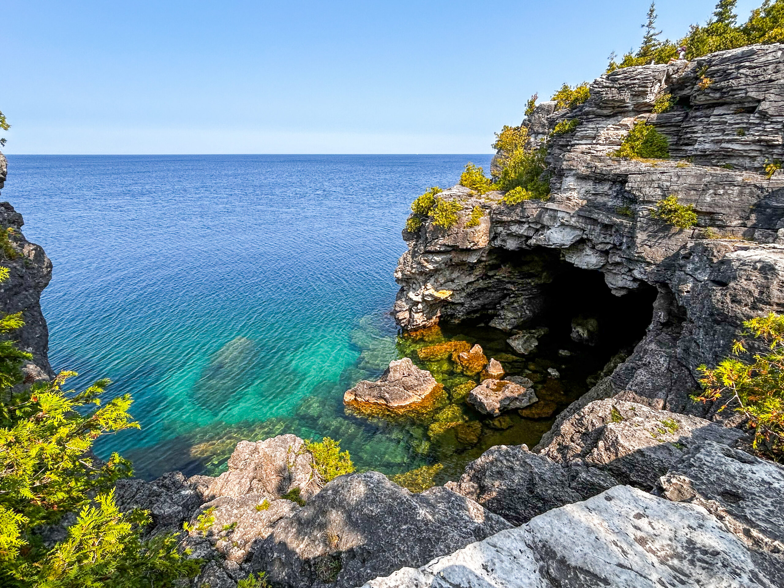
Peninsula Sunrise Series: The Grotto
https://hikes.brucetrail.org/event/peninsula-sunrise-series-the-grotto/Sorry, the registration cut-off time for this hike has been reached.Not a member? Click here to join today!Hosting Club: Peninsula
Category: Sunrise Hike
Location (Google Maps): Parking lot at Dyers Bay Rd & Hwy 6, Northern Bruce Peninsula, ON N0H 1Z0Hike Leader(s): Kathleen Stahlbaum
Pace: Leisurely (2.0 – 3.0 km/h): A relaxed pace with frequent breaks and a focus on enjoyment.
Terrain: Difficult: Steep ascents/descents, rocky scrambling, and some rugged escarpment paths., Easy: Flat forested sections or lowland trails., Moderate: Rolling hills, mild slopes and rocky paths.
Distance: ~4kmDescription
Experience the magic of dawn on the Bruce Trail with the Sunrise Hike Series offered by the Peninsula Bruce Trail Club. These early morning hikes provide a perfect opportunity to awaken your senses, boost your energy, and immerse yourself in the tranquility of nature as the sun paints the sky with breathtaking hues. As we make our way through scenic forest trails, we’ll pause to witness the first light shimmering on the turquoise waters of Georgian Bay – a sight that will surely leave you in awe!Beyond the beauty, morning light helps regulate your circadian rhythm, elevating your mood, boosting energy levels and improving sleep quality. Whether you’re looking to start your day with a sense of calm, capture stunning sunrise photos, or simply reconnect with nature, these hikes offer a unique and inspiring way to greet the day.
On Saturday August 9th, join us in hiking the Georgian Bay Trail to the Grotto at Indian Head Cove, where we’ll experience the sun rising over the Bay from the iconic shoreline before returning via the Marr Lake Trail. We’ll have the joy of taking in the stunning colours of the sky as the first light sparkles on the stunning turquoise waters. This peaceful sunrise hike is the perfect way to connect with nature, capture some incredible photos, and start the day with fresh air and inspiration. Whether you’re a morning person or just love a good adventure, come experience the magic of dawn from one of the best vantage points on the Bruce Peninsula!
Don’t forget to bring a headlamp or flashlight (preferably with a red light setting) as we begin our adventure in the pre-dawn quiet. Join us and discover how a sunrise hike can nourish your mind, body, and spirit—setting the tone for a brighter, more balanced day.
This hike is approximately 4 kms in length. Expect to be on the trail for 2.5-3 hours. Pace will be leisurely with ample time to enjoy the sunrise, take some photographs, and nourish yourself!
How to prepare
- Get a good night’s sleep
- Bring lots of water and a snack (breakfast and/or coffee are recommended if that’s your thing!)
- Bring a headlamp or flashlight (preferably with a red light setting)
- Wear waterproof hiking boots
- Hiking poles are recommended but not necessary
- Bring insect repellant or wear protective clothing
- Bring sunscreen
LIMITED SPACE AVAILABLE! We will be meeting at the parking lot at the corner of Highway 6 & Dyer’s Bay road and carpooling in 3 vehicles to Bruce Peninsula National Park. You will be required to pay for entry to the Park.

Bend. Breathe. Belong - Gentle yoga followed by an easy hike.
https://hikes.brucetrail.org/event/bend-breathe-belong-gentle-yoga-followed-by-an-easy-hike/Sorry, the registration cut-off time for this hike has been reached.Not a member? Click here to join today!Hosting Club: Iroquoia
Category: Special Event
Location (Google Maps): Under the trees at Cliffview Park 26 Upper Paradise Rd, HamiltonHike Leader(s): Ruth Moffatt Click here to contact Hike Leader(s)
Pace: Leisurely – 3km/hr or less
Terrain: Easy – Mostly flat and usually good footing
Distance: About and hour of yoga followed by an easy hikeDescription
Cost: By donation. All proceeds go to the Iroquoia Bruce Trail Club who will use the funds towards “Preserving a ribbon of Wilderness, for Everyone, Forever.”Join Certified Yoga Instructor Kristy and Certified Hike Leader Ruth, both Iroquoia Bruce Trail Club volunteers, for a morning of gentle yoga and an easy hike. Please bring your yoga mat and water and any props you like to have and afterwards you will need comfortable hiking shoes or running shoes for the hike as well as water and snacks if you need. Everyone is welcome but you must register.
Time: 8:00am to 10:00am
Date: August 9, 2025
Location: Cliffview Park 26 Upper Paradise Rd, Hamilton. (You may also park at the bottom of the Chedoke Stairs off of Beddoe Dr but you will have to walk up the staircase to join us).
Hike 6 Blue Mountain Series 6 Hikes
https://hikes.brucetrail.org/event/hike-6-blue-mountain-series-6-hikes/Sorry, the registration cut-off time for this hike has been reached.Not a member? Click here to join today!Hosting Club: Dufferin Hi-Land
Category: Cancelled
Location (Google Maps): Maple Lane Road Side ParkingHike Leader(s): Patrcia Foley and Tristan Goguen Click here to contact Hike Leader(s)
Pace: Medium
Terrain: Moderate
Distance: 10.1KmDescription
Hike 6: . We will car pool back to 3rd line south of New Mountain Rd. Today we will start with significant road walking, extreme caution should be exercised on New Mountain Rd. We will have the opportunity to catch some views of Georgian Bay and Collingwood from the top of the Blue Mountain Ski hills.We very likely encounter allot of pedestrian and bicycle traffic in the Swiss Meadows area as this is a popular short walk for many visitors to the area. Be prepared to share the trails in this area. Bug spray, sunblock and sturdy hiking shoes/boots are recommended. Bring sufficient water and lunch. Note this is a car pool hike, registration is limited and the hike leaders will have 2 dogs with them.
School Bus Hike: Elora Quarry Conservation Area/Elora & Fergus
https://hikes.brucetrail.org/event/school-bus-hike-elora-quarry-conservation-area-elora-fergus/Sorry, the registration cut-off time for this hike has been reached.Not a member? Click here to join today!Trip Information
Departure Time: 08:30
Return to City Time: 18:00
Departure Point: York Mills Bus PickupOptional Items
Hosting Club: Toronto
Category: Bus Hike
Location (Google Maps):Elora and Fergus, Ontario
Hike Leader(s): Celia Ho; Tom Swales Click here to contact Hike Leader(s)
Pace: Moderate (3-4 km/hr)
Terrain: Flat, Level 1 (Easy – mostly on flat, well maintained trails with hard-packed surface)
Distance: 8 kmDescription
Join us to visit the towns of Elora and Fergus of Wellington County, known as “Ontario’s most beautiful village”.We will walk into the town of Elora ample free time will be given to roam the streets of Elora or visit the Elora Quarry Conservation Area (you need to purchase your own tickets online before the trip for the 10AM – 2 PM slot).
After free time, we will walk on into the town of Fergus, where we will visit the Templin Gardens, Confederation Park, and downtown Fergus before stopping for refreshments.
Rockway extravaganza
https://hikes.brucetrail.org/event/rockway-extravaganza/Sorry, the registration cut-off time for this hike has been reached.Not a member? Click here to join today!Hosting Club: Niagara
Category: Hike
Location (Google Maps): Rockway conservation area. FREE ParkingPace: Brisk
Terrain: Moderate
Distance: 12kDescription
Hike the majestic trails from Rockway towards Louth including side trailsCar Hike: Boyne Valley Provincial Park!
https://hikes.brucetrail.org/event/car-hike-boyne-valley-provincial-park-4/Sorry, the registration cut-off time for this hike has been reached.Not a member? Click here to join today!Hosting Club: Caledon Hills
Category: General
Location (Google Maps): Boyne Valley Provincial Park, Map 20 of the BTC Trail Guide. County Rd. 19 (Prince of Wales Rd.) Parking Area – west of km 15.2 – approximately 80 metres south of the Prince of Wales Side Trail.Hike Leader(s): Dylan “Lana” Hubbard Click here to contact Hike Leader(s)
Pace: Brisk – 4 to 5 km/hour
Terrain: Strenuous – hilly with steep climbs and some poor footing
Distance: 17 kmDescription
Join us for an invigorating hike starting from the parking lot on Prince of Wales Rd. We’ll explore the Prince of Wales Side Trail, Primrose Loop Side Trail, main trail, and Boyne Valley Side Trail, looping back via the main trail and Prince of Wales Side Trail. Along the way, we’ll hike up the short side trail to Murphy’s Pinnacle, where you’ll be rewarded with a stunning view of the surrounding landscape – great for Instagram!Bring lunch, plenty of water, and hiking poles if you use them, as the trail is hilly. Dress for the weather.
PACE IS BRISK
This hike is a 2SLGBTQIA+ friendly space. Everyone is welcome to join us for this adventure and enjoy the beauty of the trails together.
Car Hike: Bethesda Trail Richmond Hill
https://hikes.brucetrail.org/event/car-hike-bethesda-trail-richmond-hill-34/Sorry, the registration cut-off time for this hike has been reached.Not a member? Click here to join today!Hosting Club: Toronto
Location (Google Maps): Meet at Bethesda Trail Head Parking on Bethesda Sideroad off Bayview Avenue, across from Lake Wilcox. This parking lot is free.
Hike Leader(s): Mohammad Aghamiri Click here to contact Hike Leader(s)
Pace: Moderate (3-4 km/hr)
Terrain: Hilly, Level 2 (Intermediate – some hills and uneven surfaces, rocks and roots underfoot)
Distance: 14-15 kmDescription
Join us to explore the trails of York Regional Forest and the Oak Ridges Corridor at Jefferson Forest and Bond lake,From parking lot we hike thought Jefferson forest and continue to Bond Lake and have snack beside the lake and return to parking around 13 to 13.15
For the day of hike phone number 289 588 6482

Hiking with Pride: Fern Hike at Hope Bay Nature Reserve
https://hikes.brucetrail.org/event/hiking-with-pride-fern-hike-at-hope-bay-nature-reserve/Sorry, the registration cut-off time for this hike has been reached.Not a member? Click here to join today!Hosting Club: Peninsula
Category: Rainbow Hike
Location (Google Maps): Hope Bay Nature Reserve. Meet at the south end of Cathedral Drive, at the entrance to Hope Bay Nature Reserve. Arrive a few minutes early, please.Hike Leader(s): Marg Glendon & Tainin Hopkinson Click here to contact Hike Leader(s)
Pace: Leisurely (2.0 – 3.0 km/h): A relaxed pace with frequent breaks and a focus on enjoyment., Medium (3.0 – 4.5 km/h): A comfortable pace for most hikers with steady progress.
Terrain: Easy: Flat forested sections or lowland trails., Moderate: Rolling hills, mild slopes and rocky paths.
Distance: ~4 kmDescription
Ferns can tell you a lot about the forest habitat. They are considered an “eco-indicator” – telling us about the type, moisture, nutrients and temperature of soil. The type of fern can also tell you about what kind of wildflowers to look for in the same area. Ferns are one of the oldest plants on earth. Did you know they existed at the time of dinosaurs, some growing to over 100 feet tall! While you won’t see ferns that tall, PBTC Conservation Ambassador Rhiannon Carruthers will help us to identify ferns on this hike. We like to learn from one another too – so please share your Nature knowledge throughout the hike, too. Ferns identified on this hike will contribute toward the PBTC Fern Badge. You can learn more about the Fern Badge here: https://pbtc.ca/badges/. If time allows, we will see the Hope Bay Glacial Potholes located here, too. This hike is a hike-stop-talk paced hike over uneven and at times more demanding terrain. Good balance is required.Bring a back pack for snacks and lunch, water bottle. Wear sturdy footwear with closed toes, hat, sun-protective clothing. Bring sunscreen. Hiking poles, binoculars, insect repellent (optional),
For those wishing to remain after the hike, consider staying for refreshments with us at a nearby farm or visit nearby Hope Bay Ice Cream Shop.
The closest public toilet is at the Hope Bay parking lot at 10 Hope Bay Road (about 10 minute drive).
Bruce Trail Reference Guide: Map 37 Edition 31.