Hosting Club: Caledon Hills Category: Nature Walks Location (Google Maps): Depart from Riverside Woods parking lot, Map 18, (BTC Ref Guide) off the 1st Line EHS. From Highway 10, take Hockley Valley Rd. East. Turn right onto the 5 Sideroad and then left or north on 1st Line EHS to the parking lot.
Pace: Leisurely – 3 km/hour or less Terrain: Moderate – some hills and/or some poor footing Distance: 6.5 km
Description We begin our walk on the Goodyear Memorial Side Trail, absorbing nature as we walk quietly under the forest cover. Then follow the Rushing River Side Trail down and back from the Nottawasaga River. The Goodyear Memorial Side Trail continues to lead us on through forest to the 2nd Line where we follow the main Bruce Trail to the Vineyard View Side Trail breathing in the view. Our return journey includes the vistas of the Upland Side Trail. On this Canada Day, we will share information and stories of the stone house built in 1857 – standing today, 167 years later – a house that received its historical designation in 2024!
Please bring water and carry a lunch. (Options may include a “picnic” lunch towards the end of the walk.)
Hosting Club: Dufferin Hi-Land Category: General Hike Location (Google Maps): Iroquoia Section, Map 8. Dundas Valley Conservation Area Parking Lot P3. Take DVCA Trail Centre Entrance off Governors Road, near km 51.8.
Description Oh Canada! Join us on a lovely loop hike in the Dundas Valley. We take in part of the Bruce Trail and several DVCA trails. Waterfalls like Sherman, Canterbury, and Cascade. Please bring bug spray, 3L water, snack for “elevensies”, lunch, hiking boots, poles and lots of smiles. Entrance fee to DVCA in effect at gate. Consider buying a Hamilton Conservation Area annual pass. It’s well worth it. Please arrive at 9:15 to be ready to hike at 9:30.
Pace: Moderate (3-4 km/hr) Terrain: Hilly Distance: 10 Km
Description Starting at Mississauga Road we will follow the Elora Cataract Trailway into the Forks of the Credit Park and complete a loop hike through the park, returning along the Trailway to the meeting point. There will be an opportunity to see the falls. After the hike those inclined are invited to join me for coffee or tea at the Higher Ground coffee shop in Belfountain.
To get to the meeting point go north on Mississauga Road through Belfountain. Continue about 2 km to where the Elora Cataract Trailway crosses Mississauga Road. There is parking on both sides of the road. Beware of no parking areas.
Description Hike the main and side trails in Shorthills Provincial Park. Bring hiking boots, water, sunscreen and bug spray. Please help prevent the spread of invasive species by cleaning your boots following the hike. Please check yourself for ticks following the hike.
Description We will follow the main trail, walk east along Ganaraska Trail, North on Concession Road 8 in Glen Huron. Just past Station Street, we turn west to follow the Mad River Side Trail, then join the main trail and return north to the parking lot.
Directions: From CR 124 and HW 89, north on CR 124 to Singhampton, continue east on CR124 to Devil’s Glen Provincial Parking entrance on the right.
This is Seven Rivers (aka Headwaters) series consists of 7 hikes: 3 North and 4 South. Hikers completing all 7 hikes in this series will be eligible to purchase a Seven Rivers Hike Series Badge from Dufferin Hi-Land BTC.
Hosting Club: Blue Mountains Category: Register in person the morning of hike. Location (Google Maps): Tim Hornton’s 281 First Street #4. Collingwood, ON L9Y 1B2
Pace: Medium – 3 to 4 km/hr Terrain: Moderate – Some hills and/or some poor footing Distance: 9 km
Description This is a loop trail located near Wasaga Beach. Lots of hills and options to take. This will be an exploration of some new trails to hike! Be prepared to explore the variety within this hike. Bring a snack or lunch and water.
Location (Google Maps): Our hike will begin from the parking lot of Old Baldy. km 43.9, Map 25, Edition 31. Any hike participants who do not have a parking pass for Grey Sauble CA can park on the shoulder of Sideroad 7B by the bend in the road and then be shuttled to the parking lot.
Pace: Medium Terrain: Moderate, Some rocky footing, Some steep sections Length of Hike: 5 km
Description Our hike takes us atop Old Baldy, the iconic outcrop. The Trail is well-used, the pathway often being “roots and rocks”. There will be a number of lookout spots to view into and across the Beaver Valley. We will hike along the main Trail and then turn back when we reach the road allowance part of the Trail. On the way back we will walk on the Mac Kirk Side Trail, under a canopy of deciduous trees.
COVID-19 Precautions Before, During and After your Hike
Each hiker joining a Bruce Trail Club organized hike must perform a self-screening check before hiking. Find Ontario’s self-assessment tool here: https://covid-19.ontario.ca/self-assessment/
If you are experiencing COVID-19 symptoms, stay home.
Other Guidelines
Arrive 15 minutes before the start of the hike.
Wear sturdy footwear and appropriate attire for the weather and the terrain. Hiking poles are a good idea in any season, especially if the terrain is rocky or slippery. In winter, snowshoes or icers/crampons are needed when conditions dictate. Wearing appropriate clothing and footwear prevents injuries and shows consideration for a safe and positive group hiking experience.
Always carry I.D. and your health card.
Bring sufficient water and snacks (or lunch if indicated). A minimum of 1L of water is recommended on all hikes, and 3L is recommended for long, challenging hikes in the heat of the summer.
Bring sunscreen and insect repellent (for spring and summer hikes).
Hosting Club: Sydenham Category: An evening walk. Location (Google Maps): First Avenue East Parking Lot between 8th St East and 7th St East. Owen Sound
Pace: Brisk: 4 to 5 km/h Terrain: Moderate: Some hills and/or poor footing Distance: Approx 5 km
Description Join us for an evening hike exploring Owen Sound trails and neighbourhoods, followed by an opportunity for refreshments. No need to show up 15 minutes early for this hike, but please be prepared to start promptly at 7:00 pm.
Description From Jordan Hollow Hike the main trail to Upper and Lower Balls Falls, Moyer Road or Louth and Return. You must register for each hike. Bring Poles, sunscreen, bug spray , snack and a drink and dress for the weather
Hosting Club: Caledon Hills Category: End-to-End Location (Google Maps): Meet at 9:15 am at the Hockley Road parking area, km 61.1. Shuttle to start at Mono Centre.
Pace: Medium – 3 to 4 km/hour Terrain: Moderate – some hills and/or some poor footing, Strenuous – hilly with steep climbs and some poor footing Distance: 72.4 – 61.1 + 0.750 and 0.250 side trails and road = 12.3 km total
Description This is the first hike in the series going from the north to the south of the Caledon Hills section. The trail will take us through the Whitetail Refuge Nature Reserve, up and down hills, over bridges, and through the Hockley Valley Provincial Nature Reserve.
Description Enjoy the benefits of pausing for a yoga practice as we tour through the trails, parkland and Historic Niagara-on-the-Lake. No mat required. Movement will focus on a flow of standing poses designed especially for hikers. Plan to stay for conversation and a warm cup of coffee or tea at Sweets & Swirls, Community Centre, Niagara Stone Road, NOTL.
Hosting Club: Niagara Category: Car Pool Location (Google Maps): Meet at Louth Conservation Area (Map 4) East of km 51.4. Enter from Staff Ave N43. 121706 W79.351235 Carpool back to Quarry Rd.
Hosting Club: Blue Mountains Category: Register online ONLY Location (Google Maps): Hike meets in the parking lot behind Tim Hortons on First St. in Collingwood.
Pace: Medium – 3 to 4 km/hr Terrain: Moderate – Some hills and/or some poor footing Distance: 18.5
Description Meet at Trailhead. About 18.5 km with almost 810 m elevation gain. Park your car in the small Bruce Trail Parking Lot [BTPL] on the Pretty River Road [44.428118, -80.276849]. If this small BTPL is filled, use the large Ontario Parks Lower Pretty River lot [44.430983, -80.275474]. Do not park along Pretty River Road as it is a strictly enforced no parking zone by the Town of Blue Mtns. The hike starts in the small BTPL. Proceed north on the white blazed trail until you come to the blue blazed side trail – John Haigh Side Trail. Proceed west past the highest point on the Bruce Trail. Continue until you reach the intersection of the 2nd line and 6th Sideroad. Retrace your steps to the BTPL. Have a break. Proceed east along the white blazed trail until you reach the Blue Mtns Clearview Townline. Head south and continue south past Osprey-The Blue Mountains Townline. Follow the white blazed trail until you reach the blue side trail – Standing Rock & Caves Side Trail. Turn west and take the blue blazed side trail through the Singhampton Caves until it rejoins the white blazed trail again. Turn east (left) and follow the white blazed trail which turns west and then north retracing your steps back to the parking lot. Bring lots of snacks, lunch and water. [gotohttps://www.alltrails.com/explore/map/map-march-8-2023-f875227 for a detailed map of the hike] Check the other schedules dates for associated hike description.
Description We will hike along the waterfront trail, watch birds signing and more
1-Hikers must stay between the leader and the sweep.
2-Hikers must advise the leader or the sweep if they wish to leave the group.
3- Hikers must follow the whistle instructions: 1 blast- stay where you are; 2 blasts come to the leader; 3 blasts – come to the leader quickly.
4-Hike leader may request volunteers to stop at trail intersections, they need to help hikers to the direction the group walk and wait till they see the sweep .
5-Hikers have to make sure they can see the persons behind and in front of them.
Hosting Club: Toronto Category: Cancelled Location (Google Maps): Meet at Terra Cotta’s off road parking located on a very short dirt road off Winston Churchill Blvd just south of the Main Trail. GPS N43.726474, W-79.958225. Map 14
Description On a moderate to brisk pace from Scotsdale Farm thru Silver Creek Conservation Area endingat Terra Cotta Conservation Area, we’ll make this strech a (Hike4Health-Hike4Fun). Aside from conditioning our physical and mental capacities we’ll have short fun activities and ample time for picture taking of the amazing sigths that the bruce trail offer. But, don’t be too complacent, you still have prepare for the trail surprises and challenges. Forget not your snacks and lunch, enough water for hydration. Please bring sunscreen, sun head protection and bug spray in the event we’re greeted by friendly mosquitoes. Comfortable and durable hiking shoe/boot and poles are highly recommended. Please have your personal medication and health card at your backpack. Please dress appropriately to weather forecast. Please arrive at 8:15 am (fifteen minutes) early to allow for car shuttling. Allowed no dropout.
Pace: Medium – 3 to 4 km/hr Terrain: Moderate – Some hills and/or some poor footing Distance: 12 Km
Description We will hike through the Mono Cliffs Provincial Park on the main Bruce Trail and several side trails. Bring water and snacks. Wear clothing and footwear appropriate to conditions. Insect repellent is recommended.
Park in the gravel lot at the Mono Community Centre, Mono Centre Road (County Road 8). Please arrive by 8:15 am as we will leave promptly at 8:30 am.
Pace: Moderate Terrain: Variable Distance: 13.9 Km
Description Maps 17-18, km 31.6 – km 44.3 (12.7 km) Starting Point: Roadside Parking – km 31.6 (on Innis Lake Rd, north of Finnerty Sideroad) (43.918917°N 79.909387°W) Drop-out Point: 7th Line Parking Area – km 42.2 (located off the 7th Line immediately east of Airport Rd.) (43.960477°N 79.979773°W) End Point: Parking Area – Mono 5 Sideroad – km 44.3 (on the north side of the road where the Trail crosses) (43.974055°N 79.984988°W)
Hosting Club: Blue Mountains Category: Register in person the morning of hike. Location (Google Maps): Hike meets in the parking lot behind Tim Hortons on First St. in Collingwood.
Pace: Leisurely – 3 km/hr. or less Terrain: Easy – Mostly flat and usually good footing, Strenuous – Hilly with steep climbs and some poor footing Distance: 5 km
Description We will drive via Grey Rd.119 to the end of the 6th Line in the Beaver Valley section. We will hike along the white blazed trail to km 11.3 where it joins up with the Margaret Paull Side Trail. We will follow the side trail back to the white blazed trail, then 6 Distance: 5km return to the cars. Bring water and a snack.
Description This hike will take participants to the place where Chloe Cooley’s brave act of resistance, changed the course of history in NOTL and Canada. 9 JUL 1793 saw the passing of an Act that set the stage for the great freedom movement of enslaved African Americans known as the Underground Railroad. This hike will take us along the General Brock Side Trail (GBST) and on then on the Niagara Parkway (NP). The GBST’s terrain is hilly/moderate, whereas the NP is flat/easy. On the return we will go through the Village Of Queenston and take the new sets of stairs up the escarpment, which some consider steep.
For more information about Chloe Cooley click on the link below.
PLEASE NOTE: Hikes are offered by volunteers who have committed to their own learning to be able to offer informative and contemplative hike experiences. These hikes are open to all and offered in a spirit of mutual leaning and inclusion.
This hike counts as 1 of 3 required hikes in the Summer 2024 series for the Black History badge. Look to the August schedule for more hikes in this series.
A parking fee applies or use your Niagara Falls Parking Pass. See below for information on how to order (allow at least 2 weeks for delivery by mail).
Pace: Brisk – 4 to 5 km/hr Terrain: Moderate – Some hills and/or some poor footing, Strenuous – Hilly with steep climbs and some poor footing Distance: 18 to 23 km per day
Description Hike weekends: July 6-7, July 20-21, August 24-25, September 28-29
Saturday start time: 9:30 AM (9:15 meet)
Sunday start time: 7:30 AM (7:15 meet)
This is a special series of 8 hikes to complete the entire Sydenham section of the Bruce Trail over four weekends. There will be a late start on Saturday and early start on Sunday to accommodate those travelling to the area.
There is an accomplishment badge, included in the registration fee – which was designed by Joe Borges and features the Hart’s-Tongue fern. It is easily identified by its wide, deep green leathery fronds and thought to resemble a deer’s tongue.
For this E2E in 8, we will be following the main trail southbound from Wiarton to Blantyre. Please note that you are signing up for the entire series of eight hikes as a Group Hike. The Sydenham in 8 series is geared to experienced long distance hikers with the expectation of a 3.5 to 4.5 km/hr pace maintained over an 18 to 23 km day. No dropout points have been established and therefore hikers who must drop out, will be responsible for their own transportation. Please be honest about your hiking abilities.
Hikers will be expected to wear proper hiking footwear with the expectation of hot and possibly wet weather, with trail conditions varying from dry to muddy. Please being bug spray/repellant and sunscreen if you use it. Sufficient food and min 2K of water for a full day of hiking is also required. Hiking poles and wet weather gear (if necessary) are recommended. A 10-15 minute on-trail lunch break will be scheduled.
The fee goes towards supporting the Sydenham Bruce Trail Club, which in turn supports the mission of the Bruce Trail Conservancy, which is: “Preserving a ribbon of wilderness, for everyone, forever.”
A maximum of 2 (of the 8) hikes can be self-completed as a result of scheduling challenges, but it is intended that this badge be earned while hiking as part of a group led by a certified hike leader. Car shuttles are shared amongst the hikers.
Please note there are no refunds!
The specifics for each day’s hike will be shared after registration or upon request.
TRANSPORTATION
This series will be through hikes and will require car shuttling, you must be willing to drive or to be a passenger.
Hosting Club: Toronto Category: Urban Walk Location (Google Maps):
Hike will start from McMaster University GO Bus Terminal. We will meet at Toronto’s Union Station 8:30 AM to take the 8:45 AM Train to Aldershot where we will transfer to the GO Bus for a short ride to McMaster University. On the return we take the GO Train to Toronto from West Harbour GO Train Station. If you have a smart phone then the return fare is just $10 with GO’s Weekend Pass. Seniors fare return from Union is $11.44. Hikers without a smartphone may purchase pass from Hike Leader at Union Station. If meeting us at McMaster you will have to make your way back to start by local transit or Uber and parking fee would apply.
Description This will be a one way hike through the trails of the RBG’s (Royal Botanical Gardens) South Shore Cootes Paradise Trails to Princess Point and then continuing on Hamilton’s Waterfront Trail along Burlington Bay to Bayfront Park which is a 7 minute walk to the West Harbour GO Station. Cootes Paradise is the largest and most diverse of RBG’s sanctuaries. Nestled between the Niagara Escarpment and Lake Ontario the picturesque area is significant as a migratory bird flyover zone and home to a wide variety of flora and fauna. There will be a few hills including one steeper one.
Pace: Leisurely: 3 km/h or less Terrain: Moderate: Some hills and/or poor footing Distance: 4 km
Description We will carpool to do a loop hike of 2 trails. This will be hikes 10 & 11 in the book Exploring Sydenham. There will be one secret to find. If you do not have a book and would like one ($30) let me know by using the “Contact hike leader” link.
Pace: Medium – 3 to 4 km/hr Terrain: Moderate – Some hills and/or some poor footing Distance: 15 km
Description
Starting at the Limehouse Parking Lot, the hike will follow the main trail, the Canada Goose Side Trail, the Ridge Side Trail and the Todd Bardes Meadowland Side Trail to form at 15 km loop. There will be regular breaks, including a lunch stop along the way. Bring snacks, a lunch and plenty of water. Insect repellent is recommended. Please arrive at 8:15 am as we will depart promptly at 8:30 am.
Hosting Club: Caledon Hills Category: Tuesday Hikers Location (Google Maps): Take Hwy 10 north of Orangeville about 4-5 km to Camilla, aka the Mono Centre Road, turn east and continue on this road until you reach Mono Centre. Start at Mono Community Centre parking Lot, west of km 72.2, 200 m south of Mono Centre.
Pace: Medium – 3 to 4 km/hour Terrain: Easy – mostly flat and usually good footing Distance: Approx. 8 km
Description Hike will start at Mono Community Centre on the main Bruce Trail south to the Turnbull, Springwater, and Whitetail Refuge Side Trails, then north on 3rd Line a short distance to South Outlier Loop Side Trail returning to Mono Community Centre on the main Bruce Trail. Bring water and snacks. No dogs please.
Hosting Club: Blue Mountains Category: Register in person the morning of hike. Location (Google Maps): Hike meets in the parking lot behind Tim Hortons on First St. in Collingwood.
Pace: Medium – 3 to 4 km/hr Terrain: Moderate – Some hills and/or some poor footing Distance: 7 km
Description This is one of our Friendship trails running along BTC trails and other conserved land north of Boyne Valley Provincial Park. We will park at km 29.4 on 1st Line E in the Dufferin Hi-Land section. The 7 km figure eight hike will follow the white blazed trail to km 25.4, looping back to the parking lot via the Oliver Creek Side Trail and the Moss Haven Side Trail. Bring a lunch or snack and water. *The Bibbulmun Track in Western Australia stretches 1,000 km from Kalamunda in the Perth Hills to the historic town of Albany on the south coast.
Hosting Club: Niagara Category: In and Out Location (Google Maps):
Dufferin Islands parking lot, off Burning Springs Hill, Niagara Falls. Note: a parking fee applies, as part of the Niagara Falls Parkway parking system.
Description Experience the flora in the Dufferin Islands Nature Area, Oakes Garden Theatre and in between along the Niagara Parkway. With luck the roses will be in full bloom in the Victoria Parks’ garden.
Pace: Medium Terrain: Moderate, Some steep sections Length of Hike: 5.8 km
Description This hike route quickly enters a wooded area on Valley slope. There will be plenty of up-and-down walking until we reach Eugenia Falls Conservation Area. This is a scenic section of Trail, walking along the side of the Beaver River, crossing the river and walking along more riverside. There are old structures still in place that show some of the early history of development in the area. Hikers will see a good view of the high Eugenia Falls. This hike is a there-and-back route.
COVID-19 Precautions Before, During and After your Hike
Each hiker joining a Bruce Trail Club organized hike must perform a self-screening check before hiking. Find Ontario’s self-assessment tool here: https://covid-19.ontario.ca/self-assessment/
If you are experiencing COVID-19 symptoms, stay home.
Other Guidelines
Arrive 15 minutes before the start of the hike.
Wear sturdy footwear and appropriate attire for the weather and the terrain. Hiking poles are a good idea in any season, especially if the terrain is rocky or slippery. In winter, snowshoes or icers/crampons are needed when conditions dictate. Wearing appropriate clothing and footwear prevents injuries and shows consideration for a safe and positive group hiking experience.
Always carry I.D. and your health card.
Bring sufficient water and snacks (or lunch if indicated). A minimum of 1L of water is recommended on all hikes, and 3L is recommended for long, challenging hikes in the heat of the summer.
Bring sunscreen and insect repellent (for spring and summer hikes).
Description From Jordan Hollow Hike the main trail to Upper and Lower Balls Falls, Moyer Road or Louth and Return. You must register for each hike. Bring Poles, sunscreen, bug spray , snack and a drink and dress for the weather
Hosting Club: Caledon Hills Category: End-to-End Location (Google Maps): Meet at Mono 5 Sideroad parking, km 45.4, where the trail crosses. Shuttle to start at Hockley Rd.
Pace: Medium – 3 to 4 km/hour Terrain: Moderate – some hills and/or some poor footing, Strenuous – hilly with steep climbs and some poor footing Distance: 61.1 – 45.4 + 0.250 from parking = 16 km total
Description This is the second hike in the series and takes us through the Hockley Valley Resort, pine plantations, hills and valleys. ***Please bring more than enough water for a long July hike!
Pace: Leisurely – 3km/hr or less Terrain: Moderate – Some hills and/or some poor footing Distance: Approx. 9 km.
Description Please join us as we hike this beautiful area with views from the top of the escarpment and from the bottom of Nassagaweya Canyon looking up to the escarpment. The forest will be lush and green and cool. Meet in the lower parking lot at 9:15 for a 9:30 am. start. Bring water, a snack, insect repellent and sunscreen. Hiking poles will be useful. Make a reservation with Halton Parks to enter the conservation. please contact hike leader via this form if you have any questions.
Pace: Medium – 3 to 4 km/hr Terrain: Moderate – Some hills and/or some poor footing Distance: 14 km
Description From Scotsdale Farm parking lot, we will hike the main trail and side trails in Silver Creek Conservation area for a 14k loop. Bring a snack and plenty of water. Wear sturdy footwear and clothing appropriate to conditions. Insect repellent is recommended.
Please arrive at 8:15 am as well will leave promptly at 8:30 am.
Hosting Club: Niagara Category: Urban Location (Google Maps): Park on King St near Center St, just outside of Veterans Memorial Park, Niagara-on-the-Lake
Description Each Friday we will explore different neighbourhoods, trails and parkland throughout Historic Niagara-on-the-Lake.
Moderate pace with some weeks entirely on sidewalks and roads while others may include a mix of trails and paved pathways. Great way to build up endurance for longer more strenuous hikes.
Prepare for cooler windy conditions on open parkland and along Lake Ontario and Niagara River trails.
Plan to stay for conversation and a warm cup of coffee or tea at Sweets & Swirls, Community Centre, Niagara Stone Road, NOTL
Hosting Club: Iroquoia Category: Afternoon/Evening Hikes Location (Google Maps): Meet roadside on 4th Line. Up Guelph Line from the 401, turn right on 10 Side Road and follow the curve as it becomes 4th Line.
Hosting Club: Niagara Category: Car Pool Location (Google Maps): Meet at Decew House Parking lot ( Map 3) N 43.107568 W79.249598 Carpool back to Louth Conservation Area
Description This is the longest hike in the series . Be sure to bring snacks and enough water and electrolytes. Poles are recommended. Be prepared for the weather.
Pace: Moderate Terrain: Hilly, Variable Distance: 14-17 km
Description Will explore Toronto part of Rouge park along Rouge river and Little Rouge Creek,
Some safety procedures during the hike:
1-Hikers must stay between the leader and the sweep.
2-Hikers must advise the leader or the sweep if they wish to leave the group.
3- Hikers must follow the whistle instructions: 1 blast- stay where you are; 2 blasts come to the leader; 3 blasts – come to the leader quickly.
4-Hike leader may request volunteers to stop at trail intersections, they need to help hikers to the direction the group walk and wait till they see the sweep .
5-Hikers have to make sure they can see the persons behind and in front of them.
Description We’ll hike the main trail for 10 km from Balls Falls Conservation Area to Rockway Conservation Area at a moderate pace (3.5 km/hour) while enjoying the beauty of the Niagara Escarpment (Hike4Heath-Hike4Fun). Don’t forget to bring snacks, a lunch, and sufficient water for hydration. Also bring sunscreen, sun protection, a full brimmed hat, and insect repellent in the event that we’re welcomed by friendly mosquitoes. Sturdy comfortable hiking boots/shoes and poles are highly recommended. Dress according to the expected weather conditions as per the weather forecast. There will be no dropouts. From the finish of our hike the bus will take us to Pillitteri Estates Winery where we’ll experience and enjoy a private structured wine tasting and tour hosted by one or more of the knowledgeable and friendly staff. The cost of the tasting and tour experience is $16.95 ($15.00 + HST) per person with four wines selected by the host. Please bring the fee for the tour/tasting in exact cash as it will be collected on the bus to simplify the payment to the winery estate upon our arrival. You may purchase a bottle of your favorite vino and souvenirs, if offered. If interested in attending this hike please register early (by July 7th) so the number of people expected in our group can be provided to the winery a few days in advance. Your cooperation would be appreciated.
Description Explore a lakeshore park, shoreline and cliff top trail in Niagara-on-the-Lake. This beachcombing hike involves uneven ground, clambouring over fallen trees, a pebbly beach, sandy, wet and exposed areas. Hat, sunscreen and poles are highly recommended. Please note: This is not a maintained trail and some areas may have overhanging grass and shrubs.
Pace: Moderate Terrain: Variable Distance: 15.7 Km
Description Maps 18, km 44.3 – km 60.1 (15.8 km) Starting Point: Parking Area – Mono 5 Sideroad – km 44.3 (on the north side of the road where the Trail crosses) (43.974055°N 79.984988°W) Drop-out Point: Roadside Parking – km 53.9 (on 4th Line EHS at the entrance to the Peter Beecham Side Trail) (43.976327°N 80.026621°W) End Point: Hockley Road Parking Area – km 60.1 (located on the north side of Hockley Rd at the Hockley Road Side Trail) (43.972857°N 80.056330°W)
Hosting Club: Blue Mountains Category: Register in person the morning of hike. Location (Google Maps): Hike meets in the parking lot behind Tim Hortons on First St. in Collingwood.
Pace: Leisurely – 3 km/hr. or less Terrain: Moderate – Some hills and/or some poor footing Distance: 7 km
Description We will drive to Kilgorie in the Dufferin Hi-Land section and park the cars at km 34.9 on Centre Road. From here, we will hike a figure eight loop utilizing the white blazed trail, the new Pine River Valley Side Trail and the Kilgorie Side Trail. This hike boasts a wonderful view from the Bell Tower Side Trail, ruins of an old powerhouse, the stunning Pine River, lake views, ponds, and more! The ruins of the old powerhouse along the Pine River are almost all that remain of the Dufferin Light and Power Company. Nearby is the old flume that brought water from a dam, which was constructed in 1909 and was the largest of its kind in Ontario. The plant provided power until 1923. Bring a snack or lunch and water.
Pace: Leisurely: 3 km/h or less Terrain: Easy: Mostly flat and good footing. Distance: 3km
Description Join the Sydenham and Peninsula Bruce Trail Clubs for a hike series focusing on fens. Fens are unique coastal wetlands occurring along the escarpment, meadow marshes that have conditions that are favourable for a variety of interesting species including orchids.
This easy hiking series will begin at Oliphant Fen, with a participant carpool to Petrel Point, returning to Oliphant thereafter. Observations count towards the PBTC Orchid Badge.
Come to one of the hikes or several to see how the fens change through the seasons. Carpooling encouraged – contact the hike leader if you are in need of a ride (no guarantees, but attempts will be made to help coordinate). Please plan to arrive 15 minutes in advance of the hike start time.
Please contact Jeannine, the hike leader, if you have any questions or concerns (link on this page).
Description Join us for a fun stroll through the forest as we search for turtles, dragonflies and butterflies. Finish the walk with a stop at the playground.
This hike is aimed at ages 2 to 10. Adults to accompany children and registration is to be completed for all attending. The trail is accessible for all to enjoy.
We will meet in front of the Nature Centre. Please bring bug spray, sunscreen, hats and water.
Description Earn the new E2E badge by completing the Niagara Section of the Bruce Trail in 5 hikes. This series will run each Tuesday morning for 5 consecutive weeks. If you are unable to attend all the hikes you can keep a log and complete the missed hikes at another time. You will still be able to earn the badge once all the sections are complete. Badges will be available for purchase at the end of the 5th hike. $10 for members, $15 for non members.
This is a carpool hike. Please arrive 15 minutes early so we can arrange carpooling. Driving is voluntary but we encourage all hikers to take their turn to help out. Bring water and a snack. The hikes go rain or shine. Poles, weather appropriate clothing, sturdy hiking shoes and bug spray are recommended.
We will carpool to Queenston Heights (paid parking) and hike back to the cars at Woodend Conservation.
Description Hike the main and side trails in Shorthills Provincial Park. Bring hiking boots, water, sunscreen and bug spray. Please help prevent the spread of invasive species by cleaning your boots following the hike. Please check yourself for ticks following the hike.
Pace: Medium – 3 to 4 km/hour Terrain: Moderate – some hills and/or some poor footing Distance: 11.5 km
Description We will hike the Bennett Heritage Trail, Main Trail, Maureen Smith and Irwin Quarry Side Trails from Scotsdale Farm to Silver Creek Conservation Area and back. The hike will start on the farm lane heading past the heritage buildings and barn at Scotsdale Farm. Most of the hike will be in the forest, at times following the edge of the escarpment with a few ups and downs and rocky sections.
There will be stops for water breaks along the way and a longer snack / lunch break later in the hike. Bring plenty of water, lunch, sunscreen, and bug repellent. Hiking boots required, poles recommended. Please dress appropriately for weather conditions.
Pace: Leisurely – 3 km/hour or less Terrain: Moderate – some hills and/or some poor footing Distance: approximately 3.3 km
Description From our meeting point, we will begin our exploration of the insects and arthropods that inhabit the Riverside Woods Nature Reserve following the Goodyear Memorial ST down towards Rushing River ST where we’ll highlight the importance of aquatic invertebrates to the food web and how they act as critical bioindicators for environmental health. As we ascend back up to the Goodyear ST, we’ll pass through forests and meadows and loop back via the Upland ST where a variety of important arthropod habitats exist. By then you will have learned what a true bug is and how they differ from other insects! Mosquito repellent and/or mosquito net is recommended even though we want to find and see as many other insects as possible.
Hosting Club: Blue Mountains Category: Register in person the morning of hike. Location (Google Maps): Hike meets in the parking lot behind Tim Hortons on First St. in Collingwood.
Pace: Medium – 3 to 4 km/hr Terrain: Moderate – Some hills and/or some poor footing Distance: 10-12 km
Description Standing Rock-Singhampton Caves Starting at the Franks Kiln Parking Lot on Hwy 91 we have an enjoyable hike along the white blazed trail. Following the upper escarpment, descending to the Standing Rock Side Trail where the trail turns into an obstacle course of rocks that we scramble up and maneuver around. Squeezing through cracks and crevices as we continue the ascent up through the “caves” we will arrive at the white blazed trail and loop back to parking lot.
Pace: Leisurely – 3km/hr or less Terrain: Moderate – Some hills and/or some poor footing Distance: Approx. 9 km.
Description Come out and enjoy the coolness of the forest in the summer. We will hike some of the trails of this impressive forest with its multiple hiking and biking trails. New Meeting point: northeast corner of the Mohawk/Woodbine Casino Racetrack on the west side of Guelph Line, just above the 401 at 9:15 for a 9:30 am. start. This spot is north of the 401. Bring water a snack, insect repellent and sunscreen. Poles might be helpful. Contact the leader via this form if you have any questions.
Location (Google Maps): We will meet in the parking lot of Hogg’s Falls, km 65.1, Map 26, Edition 31. From there we will take the number of vehicles necessary to go to the start of the hike. (Parking at Eugenia Falls CA is paid parking.)
Pace: Medium Terrain: Moderate, Some steep sections Length of Hike: 7 km
Description This hike begins with some views of Eugenia Falls, at the crest and through the trees. From there it’s on to the Cuckoo Valley. Beautiful views at the outstanding Cuckoo Valley lookout area. Passing through mature forest and by an upland meadow, we arrive at Hogg’s Falls, an always picturesque scene on the Boyne River.
COVID-19 Precautions Before, During and After your Hike
Each hiker joining a Bruce Trail Club organized hike must perform a self-screening check before hiking. Find Ontario’s self-assessment tool here: https://covid-19.ontario.ca/self-assessment/
If you are experiencing COVID-19 symptoms, stay home.
Other Guidelines
Arrive 15 minutes before the start of the hike.
Wear sturdy footwear and appropriate attire for the weather and the terrain. Hiking poles are a good idea in any season, especially if the terrain is rocky or slippery. In winter, snowshoes or icers/crampons are needed when conditions dictate. Wearing appropriate clothing and footwear prevents injuries and shows consideration for a safe and positive group hiking experience.
Always carry I.D. and your health card.
Bring sufficient water and snacks (or lunch if indicated). A minimum of 1L of water is recommended on all hikes, and 3L is recommended for long, challenging hikes in the heat of the summer.
Bring sunscreen and insect repellent (for spring and summer hikes).
Description From Jordan Hollow Hike the main trail to Upper and Lower Balls Falls, Moyer Road or Louth and Return. You must register for each hike. Bring Poles, sunscreen, bug spray , snack and a drink and dress for the weather
Hosting Club: Caledon Hills Category: End-to-End Location (Google Maps): Meet at Innis Lake Rd., north of Finnerty Sideroad, km 31.5. More parking is available on the south shoulder of Finnerty Sideroad east of Innis Lake Rd. Shuttle to start at Mono 5 Sideroad.
Pace: Medium – 3 to 4 km/hour Terrain: Moderate – some hills and/or some poor footing, Strenuous – hilly with steep climbs and some poor footing Distance: 45.4 – 31.5 = 13.9 km total
Description This is the third hike in the series and takes us along the Humber River, through Glen Haffy Conservation Area and into “the Dingle”.
Pace: Leisurely – 3 km/hour or less Terrain: Easy – mostly flat and usually good footing
Description This Nature Walk will take place on the Riverside Woods property off the 1st Line East of Mono. Before embarking on our walk, there will be a short instructional component on how to use the iNaturalist App to record your sightings of flora and fauna along the trail. Participants will also learn how to attach their observations to the Bruce Trail Project on iNaturalist. A short nature walk will follow where you will be encouraged to record 10 observations to iNaturalist. This session will start you on your way to earning the Caledon Hills BTC Citizen Scientist Badge. Members of all clubs are eligible to earn this badge. It would help if you downloaded the iNaturalist App and set up an account prior to joining this nature walk. If you are unable to do this, no worries, help will be available before embarking on the walk.
Description Enjoy the benefits of pausing for a yoga practice as we tour through the trails, parkland and Historic Niagara-on-the-Lake. No mat required. Movement will focus on a flow of standing poses designed especially for hikers. Plan to stay for conversation and a warm cup of coffee or tea at Sweets & Swirls, Community Centre, Niagara Stone Road, NOTL.
Join us for a fun summer day at beautiful Silent Lake Provincial Park in the heart of the Kawarthas. Hike the Silent Lake loop (15 km, 4 km/hr or more pace, no dropouts) with Martina, then cool off with a dip in Silent Lake. Or hike the Silent Lake loop at slightly slower pace with Andrew, Leila and Duro, with no time for swimming. Enjoy gorgeous views and some challenging rocks. Or join Tom for a shorter hike at a slightly slower pace and then enjoy the beach. Or come and enjoy a day on the water (self-guided) on a motorboat free lake. Canoes and kayaks can be rented at Silent Lake, or bring along your inflatable SUP.
Bring lunch, water, snacks, and your swimming gear.
No refreshment stop but there are washrooms and drinking water taps by the day use beach, and you can purchase ice cream and cold drinks in the park store.
Bus departs 10 York Mills Rd at 7:30 AM. Registration cost includes bus fare and park admission.
Pace: Moderate Terrain: Variable Distance: 14-17 km
Description
Some safety procedures during the hike:
1-Hikers must stay between the leader and the sweep.
2-Hikers must advise the leader or the sweep if they wish to leave the group.
3- Hikers must follow the whistle instructions: 1 blast- stay where you are; 2 blasts come to the leader; 3 blasts – come to the leader quickly.
4-Hike leader may request volunteers to stop at trail intersections, they need to help hikers to the direction the group walk and wait till they see the sweep .
5-Hikers have to make sure they can see the persons behind and in front of them.
Hosting Club: Caledon Hills Category: General Location (Google Maps): Hockley Valley Nature Preserve, Map 18. To reach the meeting point, drive north on Hwy 10 from Orangeville and turn right onto Hockley Road. Continue approximately 5 km east until you see the parking area on your left, directly across the road from the Black Birch restaurant.
Pace: Medium – 3 to 4 km/hour Terrain: Strenuous – hilly with steep climbs and some poor footing Distance: 14 km
Description THIS HIKE HAS BEEN CANCELLED DUE TO INCLEMENT WEATHER
Join us for a 14 km hike through the Nature Preserve, known for being one of the most challenging and hilly sections of the Bruce Trail. Get ready for a workout, After the hike, those interested are welcome to join me at the Hockley Valley Resort for refreshments.
We are committed to providing an inclusive and welcoming environment. This hike is an 2SLGBTQIA+ safe space, and everyone is welcome to join us!
Pace: Leisurely, Medium Terrain: Difficult, Moderate Distance: ~5-7 km
Description Ferns can tell you a lot about the forest habitat. They are considered an “eco-indicator” – telling us about the type, moisture, nutrients and temperature of soil. The type of fern can also tell you about what kind of wildflowers to look for in the same area. Ferns are one of the oldest plants on earth. Did you know they existed at the time of dinosaurs, some growing to over 100 feet tall! While you won’t see ferns that tall, PBTC Trail Ambassador Rhiannon Carruthers will help us learn how to identify ferns on this hike. Ferns identified on this hike will contribute toward the PBTC Fern Badge. If time allows, we will see the Hope Bay Glacial Potholes located here, too. This hike is a hike-stop-talk paced hike over uneven and at times more demanding terrain. Good balance is required.
Pace: Medium – 3 to 4 km/hr Terrain: Moderate – Some hills and/or some poor footing Distance: 5 km
Description We will drive to the parking lot on 15/16 Sideroad in Singhampton then commence a loop hike through the Nottawasaga Bluffs. There will be great views and varied terrain. Fun scrambling over and down rocks and crawling through the Keyhole! Bring a snack and water.
Hosting Club: Sydenham Category: General Hike Location (Google Maps): The Owen Sound Galaxy Cinema parking lot. Meet at the tall “Galaxy Centre” sign next to the traffic lights.
Pace: Medium: 3 to 4 km/h Terrain: Moderate: Some hills and/or poor footing, There might be muddy sections., There might be sections with water on the trail. Distance: 8 km
Description We will hike the Slough of Despond Side Trail looping via The President’s Path Side Trail returning to our starting point then taking the Main Trail to an outstanding viewing opportunity before returning via Chris Walker Side Trail. BTC Map # 34 – Edition 31.
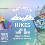
Pace: Leisurely: 3 km/h or less Terrain: Moderate: Some hills and/or poor footing, Strenuous: Hilly with steep climbs and some poor footing. Distance: 4.8 km
Description Join us on a Rainbow Hike for 2SLGBTQ+ folx and allies, while we explore the Woodford Escarpment.
This hike begins at the Woodford Community Hall in the hamlet of Woodford.
We will enter a mixed hardwood forest, passing the stone foundation of a Pioneer Church, then the remnants of an old limestone kiln ingeniously constructed from a glacial pothole. The trail continues through the forest, passing over a “disappearing waterfall” (dry at this time of year), then alongside the foundation of a settler’s barn and cabin, before reaching a narrow crevice.
Woodford crevices are exciting to explore slowly. It is a short, very narrow passage through the escarpment with strenuous terrain. In the summer the passage walls are cool. You’ll feel the air-conditioning emitting from the rocks of the crevice. At the same time, its a short but adventurous exploration! If anyone is claustrophobic or chooses not to follow the narrow crevice, there is a By-Pass trail to follow instead. At the end of the first section of crevices, the trail climbs up to the top of the escarpment where hikers can visual follow the passage from above. Once through both sections of crevices, the trail reaches the Woodford Escarpment Side Trail which will will follow to return to the parking area. Together with the main trail, this forms a 3 km loop hike.
Once back to Woodford Community Hall, we’ll continue south, crossing Hwy 26 and following the main trail for about 500 metres before reaching the Crevice Springs Side Trail. This trail descends the talus slope and continues northward through a mature cedar forest, crossing numerous springs before ascending through an interesting crevice, known locally as “the hole-in-the-wall”. Together with the main trail, this forms a 1.4 km hike.
What to Bring: Please carry a backpack with snacks and at least one litre of water and/or electrolytes. Sunscreen and insect repellent are recommended.
What to wear: Light sweat-wicking clothing is best in summer to keep you cool. Sturdy shoes with a good tread on rocky surfaces with socks. No open-toed shoes or “croc” style please.
Description We will hike a loop on the main trail from Malivoire Wine Co to the Margaret Reed Side Trail at Cave Springs Conservation Area and back to Malivoire Wine Co by 11:30. Upon return we will enjoy a private structured wine tasting led by one of the knowledgeable and friendly winery staff from 11:30 to 12:00 noon. The cost for the tasting experience is $12.00 per person. Please bring your $12.00 with you as I will collect it prior to the tasting to simplify the payment to Malivoire Wine Co. Thank you.
Hosting Club: Toronto, Dufferin Hi-Land Category: Car Hike Location (Google Maps): We will meet at roadside parking on Prince of Wales Road/County Road 19 south of 5 Sideroad – where the Primrose Loop ST crosses the road (Map 20 of the Bruce Trail Reference Guide, Edition 31).
Pace: Leisurely Terrain: Variable Distance: 6.6 km
Description Calling all families with children who love hiking and earning badges!!!
This is the seventh in a series of ten hikes that will be offered throughout 2024 on a roughly monthly basis so that children who are 15 years of age and younger can earn the Dufferin Hi-Land Adventurer Youth Badge and their parents/guardians can earn the Dufferin Hi-Land Side Trails Badge at the same time!!! Details regarding the requirements for each badge can be found here: https://dufferinbrucetrailclub.org/dufferin-bruce-trail-club-badges/ Each of the ten hikes will be a loop hike so no car shuttles will be needed, and each hike will cover a distance of approximately 6-9 km hiked at a leisurely pace (2-3 km/h) so children and adults alike can participate.
This seventh hike will be a summer hike to continue exploring some side trails within Boyne Valley Provincial Park, specifically the Primrose Loop Side Trail and the Prince of Wales Side Trail. Please dress appropriately for a summer hike by dressing in lightweight and breathable clothing, wearing a sunhat, and wearing comfortable footwear that has good traction. It is also advised that you bring sunscreen, bug spray, a light sweater, and suitable rain apparel in case conditions require their use. As well, make sure you bring enough water and food for a 2-3 hour hike since we’ll be covering a total distance of approximately 6.6 km.
Hopefully you’ll be able to join me on Sunday, July 21st! Until then, happy hiking, everyone!
Pace: Leisurely: 3 km/h or less Terrain: Moderate: Some hills and/or poor footing Distance: 4.5 km
Description We will carpool to do a loop hike in the Bayview Nature Reserve. This is hike 12 in the book Exploring Sydenham. If you do not have a book and would like one ($30) let me know by using the “Contact hike leader” link.
Description Meet down at Harbourfront and then join us on a lovely summer afternoon walk along the Toronto Waterfront Trail. We will end the walk at Woodbine Park. Please stick around after the walk to enjoy the free Bob Marley Tribute Concert beginning at 6:30 p.m. and that is part of the very popular Beaches Jazz Festival.
Pace: Brisk – 4 to 5 km/hr, Medium – 3 to 4 km/hr Terrain: Dependent on Conditions, Easy – Mostly flat and usually good footing, Moderate – Some hills and/or some poor footing Distance: About 10-12km
Description Occasionally hikes are put on the schedule for hikes outside of the Bruce Trail. This one is near Grand Bend, Ontario and involves a 2 hour drive there and a 2 hour drive back, possible closer to 3 depending on road construction and traffic.
This hike is limited to 6 participants in one vehicle. We will travel from Niagara making a pick up at the carpool parking lot in Grimsby (sw corner of the QEW/Casablanca) in the Go Bus parking lot and another stop at the carpool lot on Wilson St West, Ancaster
From there we will travel to Parkhill, as above. More hikers can come if someone else wishes to drive or you can meet us there. Just let me know through contact on this form. Registration is still necessary but the number of hikers can be increased if need be. We will hike the two required trails in the Ausable River Valley https://img1.wsimg.com/blobby/go/72882546-4158-474e-bfd0-32a9f78441a3/downloads/Ausable%20River%20Valley%20%26%20Mystery%20Falls.pdf?ver=1720533688263
The badge is free but donations would be gratefully accepted by the Lambton Shores Nature Trails. Please bring the printed log with you which will need to be completed and submitted to the club. Someone from the club will be meeting us with the badges at the turnaround spot. Gas expense will be shared amongst the passengers. Please bring enough supplies in your backpack for a full day of hiking – 2l of water, lunch, snacks, first aid kit etc.
Check for weather conditions and bring appropriate gear for the weather. If there is extreme weather forecast, the hike will be cancelled.
Description Earn the new E2E badge by completing the Niagara Section of the Bruce Trail in 5 hikes. This series will run each Tuesday morning for 5 consecutive weeks. If you are unable to attend all the hikes you can keep a log and complete the missed hikes at another time. You will still be able to earn the badge once all the sections are complete. Badges will be available for purchase at the end of the 5th hike. $10 for members, $15 for non members.
This is a carpool hike. Please arrive 15 minutes early so we can arrange carpooling. Driving is voluntary but we encourage all hikers to take their turn to help out. Bring water and a snack. The hikes go rain or shine. Poles, weather appropriate clothing, sturdy hiking shoes and bug spray are recommended.
We will carpool to Woodend Conservation and hike back to the cars at DeCew House.
Description Hike the main and side trails in Shorthills Provincial Park. Bring hiking boots, water, sunscreen and bug spray. Please help prevent the spread of invasive species by cleaning your boots following the hike. Please check yourself for ticks following the hike.
Description We will meet in the parking lot and walk a loop along the Island crossing over the tracks to return to main street. This is an easy hike with open areas. Please dress for weather and bring water, sun screen and bug spray.
We will have some social time for coffee at the end of hike for those that would like to join.
Hosting Club: Blue Mountains Category: Register online ONLY Location (Google Maps): Hike meets in the parking lot behind Tim Hortons on First St. in Collingwood.
Pace: Leisurely – 3 km/hr. or less Terrain: Easy – Mostly flat and usually good footing Distance: 4.3 km
Description Flower ports are created by water that exploits cracks and eventually removes the material between the flowerpot and the main rock face. The water smooths and round the rock of the flowerpot. The flowerpots at Indian Brook were created several thousands of years ago when lake levels were significantly higher than they are today.
Description From Jordan Hollow Hike the main trail to Upper and Lower Balls Falls, Moyer Road or Louth and Return. You must register for each hike. Bring Poles, sunscreen, bug spray , snack and a drink and dress for the weather
Hosting Club: Caledon Hills Category: End-to-End Location (Google Maps): Meet at Willoughby Rd. and Escarpment Sideroad, km 15.9. Shuttle to start at Innis Lake Rd.
Pace: Medium – 3 to 4 km/hour Terrain: Easy – mostly flat and usually good footing, Moderate – some hills and/or some poor footing Distance: 31.5 – 15.9 = 15.6 km total.
Description This is the fourth hike of the series and involves a lot of road walking but with good views toward Lake Ontario and the GTA. The trail takes us along the Paris Moraine, and through a tunnel under Hurontario Street.
Hosting Club: Dufferin Hi-Land Category: General Hike Location (Google Maps): Intersection of 10 Side Road and Fourth Line just east of Guelph Line and north of the 401.
Pace: Medium Terrain: Slippery Sections Likely, Moderate Distance: 17 kms
Description Join us for a hike at the top of the Sixteen Mile Creek watershed in the Halton Agreement Forest. We will take in a Hilton Falls engorged with the recent epic rain we just had. It was literally overflowing a week ago. Please be prepared for the heat and wet and possibly buggy conditions. We are starting early (8:30 am) to avoid the worst heat of the day. Please bring 3L of water, a snack, a lunch, bug spray, long sleeves and long pants, a hat, a bug net and a smile.
Hosting Club: Niagara Category: Urban Location (Google Maps): Park on King St near Centre St at the entrance to Veterans Memorial Park, Niagara-on-the-Lake
Description Each Friday we will explore different neighbourhoods, trails and parkland throughout Historic Niagara-on-the-Lake.
Moderate pace with some weeks entirely on sidewalks and roads while others may include a mix of trails and paved pathways. Great way to build up endurance for longer more strenuous hikes.
Prepare for cooler windy conditions on open parkland and along Lake Ontario and Niagara River trails.
Plan to stay for conversation and a warm cup of coffee or tea at Sweets & Swirls, Community Centre, Niagara Stone Road, NOTL
Hosting Club: Niagara Category: Car Pool Location (Google Maps): Meet at Queenston Heights Park, km 0.0. Park near the cairn. N43.157826 W79.052045 Carpool back to Woodend Conservation Area
Description Badge Day for those who have completed all 5 hikes! Bring snacks and plenty of water. Poles are recommended. Be prepared for the weather. Bring $10 for the new badge if you have completed all 5 hikes.
Pace: Medium – 3 to 4 km/hr Terrain: Moderate – Some hills and/or some poor footing Distance: 10 km
Description about 10 km with almost 400m elevation gain. Park your car in the Devil’s Glen Provincial Park Parking Lot [44.36161, -80.20824] The hike starts here. Follow the white blazed trail south and down to the Devil’s Glen Country Club Parking Lot. Proceed east on the blue blazed Mad River Side Trail. Continue parallel to the Mad River, through Glen Huron and south on Conc 8 S.CR #62 until you come to Sideroad 15-16 Nottawasaga. Here you will see both white and blue blazes. This is a shared Bruce Trail/ Ganaraska Trail section. Continue up the hill until you see the Ganaraska Trail End Marker – a large boulder close to the Devil’s Glen Country Club Gate. Turn around and head back to the cars. For a detailed map… [go to https://www.alltrails.com/explore/map/r2r-2-a666587
Description Originally known as Ashquasing (that which lies at the end), the Twelve Mile Creek has served all the locals well. The original name was provided by the Mississaugas, and they inhabited the area some 9500 to 2900 years ago. After becoming a waterway for transportation, industry, and electrical power, it is recognized as the only cold water stream in the Niagara Region. It has now become one of my favourite running routes, and along with the Downtown St. Catharines Business Association, we are determined to have more walkers, hikers and runners experience its natural beauty.
In 1829, the first Welland Canal began its operation and it used the waters and path of the Twelve-Mile Creek to connect Lake Ontario to Lake Erie. There is a lot to discover and to learn!
Please bring water, snacks, a hat and bug spray. There will be a block party immediately following the hike, so come and hang out with us.
Hosting Club: Caledon Hills Category: General Location (Google Maps): Scotsdale Farm, Map 13. Directions; from Highway 401, head north on Trafalgar Road past Georgetown. Trafalgar briefly merges with Highway 7 for about 3 km before separating to the right at the village of Silver Creek. At the stop light in Silver Creek, continue north on Trafalgar Road for about 1 km to the entrance of Scotsdale Farm on your right. Drive in about half a kilometre to reach the parking area.
Pace: Medium – 3 to 4 km/hour Terrain: Moderate – some hills and/or some poor footing Distance: 11 km
Description Description Join us for a loop hike along the main Bruce Trail and various side trails, including the scenic Great Esker Side Trail. After the hike, everyone is welcome to gather at the Shepard’s Crook in Georgetown for refreshments.
We are committed to providing an inclusive and welcoming environment. This hike is an LGBTQ+ safe space, and everyone is welcome to join us.
Hosting Club: Toronto, Blue Mountains Category: Car Hike Location (Google Maps): Where Pretty River Access Trail leaves Pretty River Rd. N44.424089, W80.288414
Description The beauty of hiking is about savouring the experience, cherishing the views and the chance to connect with nature and people. Join me in hiking the scenic Nottawasaga Lookout Nature Reserve and the Standing Rock and Caves Side Trail. Let’s enjoy the amazing beauty of it’s cliffs, crevices and ravine habitants along the forested slope that offers the cross section of the Escarpment flora, fauna and topography. We’ll be at moderate pace of 3-4 kph to enjoy the beautiful landscape. Bring snack, lunch and sufficient water to quinch your thirst. Bring sun screen, sun head protection and bug spray in the event our friendly mosquitoes welcome us. Hiking shoe and poles are strongly recommended. Please dress appropriately as to weather forecast. Have your personal medications and health card with you at all times. Please arrive fifteen minutes early.
Hosting Club: Blue Mountains Category: Register in person the morning of hike. Location (Google Maps): Hike meets in the parking lot behind Tim Hortons on First St. in Collingwood.
Pace: Leisurely – 3 km/hr. or less Terrain: Moderate – Some hills and/or some poor footing Distance: 6.5 km
Description This hike is through the 284 acres of Balsam Wetlands. We will park at km 34.2 on Concession 10 South and proceed hiking across a farmer’s field and continue through a pine forest. This hike has recently been realigned so that it no longer follows the Highlands Nordic cross country ski trail and now goes through woodlands and some 9 interesting rock formations to the Duntroon Quarry. We will then follow the white trail passing some deep crevices to the Bruce Trail parking lot off 91. Hikers will then be shuttled back to the cars. Bring a snack and water.
Pace: Moderate Terrain: Hilly, Rocky Distance: 10 km
Description Join us for a moderate paced hike with magnificent views along the Niagara Escarpment. A few short hills. One “mini canyon” accessible by wooden steps. We will take lots of stops for water breaks and to take in the views at the lookout points. Dropouts at 3 km and 6 km. Hiking boots are required. Refreshment stop at Tim Hortons and Longos on Highway 5. Bring lunch for a lunch break on the trail and plenty of drinking water (at least 2 Litres). Return to Toronto by 6:00 PM. Departing York Mills with an optional pick-up at Lisgar GO Station NW Mississauga (Winston Churchill Blvd/Hwy 401) – If you wish to be picked up at Lisgar GO Station select this option when registering.
Hosting Club: Sydenham Category: General Hike Location (Google Maps): Meet in the north-east corner of the parking lot at Home Depot on Highway 26 on the east side of Owen Sound.
Pace: Fast: more than 5 km/h, Medium: 3 to 4 km/h Terrain: Moderate: Some hills and/or poor footing, There might be muddy sections., There might be sections with water on the trail. Distance: 12 km
Description We will loop along the Main Trail through the Bayview Escarpment Provincial Nature Reserve starting at km 52.7 to 44.6 then follow the River Kwai Side Trail to return to our starting point via a short section again on the Main Trail – BTC Map # 30 edition. If you are interested in visiting Coffin Ridge for refreshments afterwards, please email the Hike Leader.
Description Support local conservation and stewardship! Baking for Conservation is a unique and intimate culinary experience and fundraiser. Combine your interest in baking with your love for the Bruce Trail. Learn how to make delicious baked scones with scone accompaniments of whipped ricotta with honey and compound butter with lemon in a beautiful, large home kitchen. This lovely home setting is nestled at the forest fringe near Cape Chin North with the sound of the gentle waves of Georgian Bay washing up on the nearby shore. You will make the scones and toppings and then enjoy a delightful scone-tea party. All supplies are provided. Take home recipes and tips are provided by our certified culinary host, Laura Tilly. Optional – join us for a short post-event hike for views of picturesque Georgian Bay and see examples of local conservation and stewardship projects. Free will donation. All proceeds will be dedicated to Bruce Trail Conservancy for local PBTC Conservation and Stewardship projects. Please consider donating generously. Tax receipt will be given upon registration for donations over $20.
Description Earn the new E2E badge by completing the Niagara Section of the Bruce Trail in 5 hikes. This series will run each Tuesday morning for 5 consecutive weeks. If you are unable to attend all the hikes you can keep a log and complete the missed hikes at another time. You will still be able to earn the badge once all the sections are complete. Badges will be available for purchase at the end of the 5th hike. $10 for members, $15 for non members.
This is a carpool hike. Please arrive 15 minutes early so we can arrange carpooling. Driving is voluntary but we encourage all hikers to take their turn to help out. Bring water and a snack. The hikes go rain or shine. Poles, weather appropriate clothing, sturdy hiking shoes and bug spray are recommended.
We will carpool to DeCew House and hike back to the cars at Louth Conservation.
Description Hike the main and side trails in Shorthills Provincial Park. Bring hiking boots, water, sunscreen and bug spray. Please help prevent the spread of invasive species by cleaning your boots following the hike. Please check yourself for ticks following the hike.
Hosting Club: Caledon Hills Category: General Location (Google Maps): Riverside Woods; parking area on the east side of 1st Line EHS, north of 5 Sideroad, Map 18.
Pace: Leisurely – 3 km/hour or less Terrain: Moderate – some hills and/or some poor footing Distance: 6 km
Description Join Joyce, Marilyn, and Louise on this 2 hour, 6 km hike which is the 6th in the series of hikes for the new “60 for the 60th Anniversary” badge. We will hike in a shaded area of Riverside Woods to the Nottawasaga River and back. Hike one, a few, or all 10 hikes. Join any hike and make up the rest on your own as long as a record is kept of their hikes to submit on completion to obtain their badge. Participants who complete all 10 hikes will be eligible to purchase the “60 for the 60th” badge. Bring poles, and hydration.
Hosting Club: Blue Mountains Category: Register in person the morning of hike. Location (Google Maps): Hike meets in the parking lot behind Tim Hortons on First St. in Collingwood.
Pace: Leisurely – 3 km/hr. or less Terrain: Easy – Mostly flat and usually good footing Distance: 5 km
Description Hike this 204 acre property featuring majestic mature sugar maple trees and a meandering cold water stream. This lush Niagara Escarpment forest is home to a variety of rare and at-risk species. The sounds of hairy and pileated woodpeckers echo through the trees. We will creatively combine Mingay, Maple Leaf and Trout trails to complete a loop-deloop. Bring a snack and water
Pace: Leisurely: 3 km/h or less Terrain: Easy: Mostly flat and good footing. Distance: 2km
Description Join the Sydenham and Peninsula Bruce Trail Clubs for a hike series focusing on fens. Fens are unique coastal wetlands occurring along the escarpment, meadow marshes that have conditions that are favourable for a variety of interesting species including orchids.
This easy hiking series will take place at Oliphant Fen, with a visit to Petrel Point on select other dates. Observations count towards the PBTC Orchid Badge.
Come to one of the hikes or several to see how the fens change through the seasons. Carpooling encouraged – contact the hike leader if you are in need of a ride (no guarantees, but attempts will be made to help coordinate). Please plan to arrive 15 minutes in advance of the hike start time.
Please contact Jeannine, the hike leader, if you have any questions or concerns (link on this page).
Hosting Club: Caledon Hills Category: Tuesday Hikers Location (Google Maps): Meet where the Trail crosses Twiss Rd. just north of Derry Rd. — Map 10, km 101.6. This is 7342 Twiss Rd., Campbellville.
Pace: Medium – 3 to 4 km/hour Terrain: Moderate – some hills and/or some poor footing Distance: 10 km
Description From Twiss Rd. we will hike south on the Main Trail to Kilbride where we can enjoy the new reroute that takes the trail off the road. Return by the same route.
Pace: Medium Terrain: Moderate, Some rocky footing, Some steep sections Length of Hike: 5 kms
Description
Our hike takes us along a route that showcases much of the new construction that has recently been completed in the Hogg’s Falls area. Multiple bridges across the Boyne River allow for hiking loops. We will walk southward from the parking lot along the Main Trail and then we will cross the Boyne River. The Trail rises well above the Boyne River meaning there’s some steep inclines. Another bridge is crossed to return to the other side of the Boyne and then we include a loop into uplands. A visit to see the Falls is a special view.