- HikeType Car Hike
- HikeIcon https://hikes.brucetrail.org/wp-content/uploads/formidable/7/marker_car-hikes.png
- PaceTypes Brisk
- TerrainTypes ,Hilly,Variable
- PaidOuting Yes
Hike open to BTC Members only.
This is a Multi-Day Hike
You are signing up for the following dates and times:
2024-06-14 at 08:30
2024-06-15 at 08:30
2024-06-16 at 08:30
2024-06-17 at 08:30
2024-06-21 at 08:30
2024-06-22 at 08:30
2024-06-23 at 08:30
2024-06-24 at 08:30
Registration Required:
Registration Cost
Members - $30.00
Child Members - $44.00
Hosting Club: Toronto, Beaver Valley
Category: Car Hike
Location (Google Maps): Hike 1- Maple Lane, km 67.3 Blue Mountain on map 24. It is also km 0.0 of the BV. Coordinates N 44504973,W 80.331780
Hike Leader(s): Smadar Junkin Click here to contact Hike Leader(s)
Pace: Brisk
Terrain: Hilly, Variable
Distance: 13.7 km
Description
This is a fundraiser hike to keep the pledge of “ ribbon of wilderness for everyone forever “. The funds will be collected by the Toronto Bruce Trail Club and will be transferred to the Beaver Valley Club to help continuing the gear maintenance work that the team of volunteers doing.
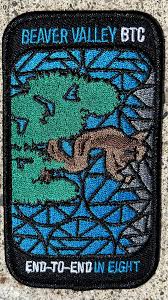
this hike will earn you the special stained glass badge of the BV.
you will be permitted to miss two of the organized hikes and make them up on your own to get the badge.
hike2- meet at km 27.9 parking- a 100 meters south of the main trail across the 10th line coordinates N 44.416209,W 80.443557 we will shuttle to 6th line. Map 25
hike 3- meet at at the same place as hike 2 and shuttle to km 43.5 map 25
hike 4- meet at km 43.6 side road 7B coordinates N 44.395310,W 80.518495 we will shuttle to km 56.1 north street. Map 26
hike 5- meet at km 71.7 Johnston side road parking. Coordinates N 44.315674,W 80.549984 we will shuttle to NorthStreet.
hike 6- we will meet at the same place as hike 5 and shuttle to km 86.9 side road 13A map27
hike 7- we will meet at km 86.9 side road 13A coordinates N 44.420867,W 80.562233 we will shuttle to km 99.9. Map 27
hike 8 badge day we will meet at Blantyre km 117,3 and shuttle to km 99.9. Please note that at this time the parking in Blantyre is closed. The resident across the street kindly offered us parking in an area in his property. At this time I’m not sure if the the parking will be open. More information to come at the later date.
after each hike I will be hiking a geology hike to to learn about the geology of the beaver valley and to earn the badge. If you wish to join me, let me know and I’ll send you information closer to the time of the hikes. These will not be official Bruce Trail hikes. If you are interested it might be a good idea to get Beth Gilhespy’s book “Walking Through Time” from. The conservancy office.
please bring two litres of water to each hike, bug prevalent and sun screen.