Join us for a hike! Registration required:
All hikes available to BTC members. Some hikes are open to non-members.
TIP: The calendar view displays up to 7 hikes on a day, but often there are more. Click “More events” to see them all.
Toronto Hike Schedule
Toronto Bruce Trail Club Registration Live Dates
Day Winter Coach Program
Registration begins two weeks in advance of the event departure (at 8:00 PM)
Day Bus Hikes
Registration begins two weeks in advance of the event departure (at 8:00 PM) with some exceptions of special event hikes
Day Coach Hikes
Registration begins 7 weeks in advance of the event departure
Day Car Hikes and Urban Hikes
Registration begins two weeks in advance of the event departure
Overnight and Weekend Trips
Registration begins 12 weeks in advance of the event departure
To view all Bruce Trail Conservancy Hikes click here
- 16May 16, 2026
Car Hike: Blue Mountains E2E #1/4
https://hikes.brucetrail.org/event/car-hike-blue-mountains-e2e-1-4/Sorry, the registration cut-off time for this hike has been reached.Not a member? Click here to join today!Hosting Club: Toronto, Blue Mountains
Category: Car Hike
Location (Google Maps): Meet up roadside parking on Mulmur-Nottawasaga Townline, 550 meters east of Lavender Hill Rd in front of the cemetery. GPS N44.268777, W80.156810.Hike Leader(s): Ross Estrella Click here to contact Hike Leader(s)
Pace: Brisk (4-5 km/hr), Moderate (3-4 km/hr)
Terrain: Challenging, Hilly, Level 2 (Intermediate – some hills and uneven surfaces, rocks and roots underfoot), Rocky
Distance (km): 22kmDescription
Day 1/4 of BMBTC E2E. Hikers must complete the entire Blue Mountain section to earn and receive their badge upon completion. Missed segment/s must be made up prior to the completion of the last segment to receive your badge. Hikers who are completing their missed section of BMBTC are welcome to join. This segment will pass thru the Noisy River Provincial Nature Reserve and Nottawasaga Bluffs Conservation Area. Expect some challenging rolling hills, rocks and underfoot trail but you’ll be rewarded with stunning beauty of the surrounding landscape. We’ll be on a moderate to brisk pace. Day hike essentials to bring; lunch/snacks, sufficient liquid hydration of your choice, sun screen, bug spray, head covering for sun protection and dress appropriately for the forecasted weather. As we are in the middle of spring season some section could be muddy/slippery therefore, hiking poles, waterproof hiking shoe and gaiter are strongly recommended. Fifteen minutes early arrival is expected and please make sure your car ready for shuttling.We’ll shuttle to small parking area off 15/16 Sideroad accessible only from Con 10 South. GPS N44.342784, W80.210628
Cost of badge is ten dollars for BTC members and fifteen dollars for non members.
Trillium hike Richmond Hill
https://hikes.brucetrail.org/event/car-hike-bethesda-trail-richmond-hill-38/Sorry, the registration cut-off time for this hike has been reached.Not a member? Click here to join today!Hosting Club: Toronto
Location (Google Maps): Oak Ridges Corridor, Bethesda Trail Head Parking Lot, Bethesda Side Road, Richmond Hill, Ontario
Hike Leader(s): Mohammad Aghamiri Click here to contact Hike Leader(s)
Pace: Moderate (3-4 km/hr)
Terrain: Hilly, Level 2 (Intermediate – some hills and uneven surfaces, rocks and roots underfoot), Variable
Distance (km): 14-15 kmDescription
Join us to explore the trails of York Regional Forest and the Oak Ridges Corridor at Jefferson Forest and Bond lake,Now is the trillium time come and view thousands of this beautiful flower.
The White Trillium became Ontario’s official flower in 1937. The Trillium blooms in early spring throughout the province, with its white blossom associated with peace and hope.
From parking lot we hike thought Jefferson forest and continue to Bond Lake and have snack beside the lake and return to parking around 13 to 13.30
Please bring lots of water and snacks ,hiking poles are recommended
phone number for the day of hike 289 588 6482
School Bus Hike: Louth Falls and Ball's Falls
https://hikes.brucetrail.org/event/school-bus-hike-louth-falls-and-balls-falls/Sorry, the registration cut-off time for this hike has been reached.Not a member? Click here to join today!Trip Information
Departure Time: 08:30
Return to City Time: 18:00
Departure Point: Kipling Departure PointOptional Items
Hosting Club: Toronto
Category: Bus Hike
Location (Google Maps): Balls Falls, Louth CAHike Leader(s): Felix Wan; Tim Wainwright Click here to contact Hike Leader(s)
Pace: Moderate (3-4 km/hr)
Terrain: Hilly, Level 2 (Intermediate – some hills and uneven surfaces, rocks and roots underfoot), Rocky, Variable
Distance (km): 11Description
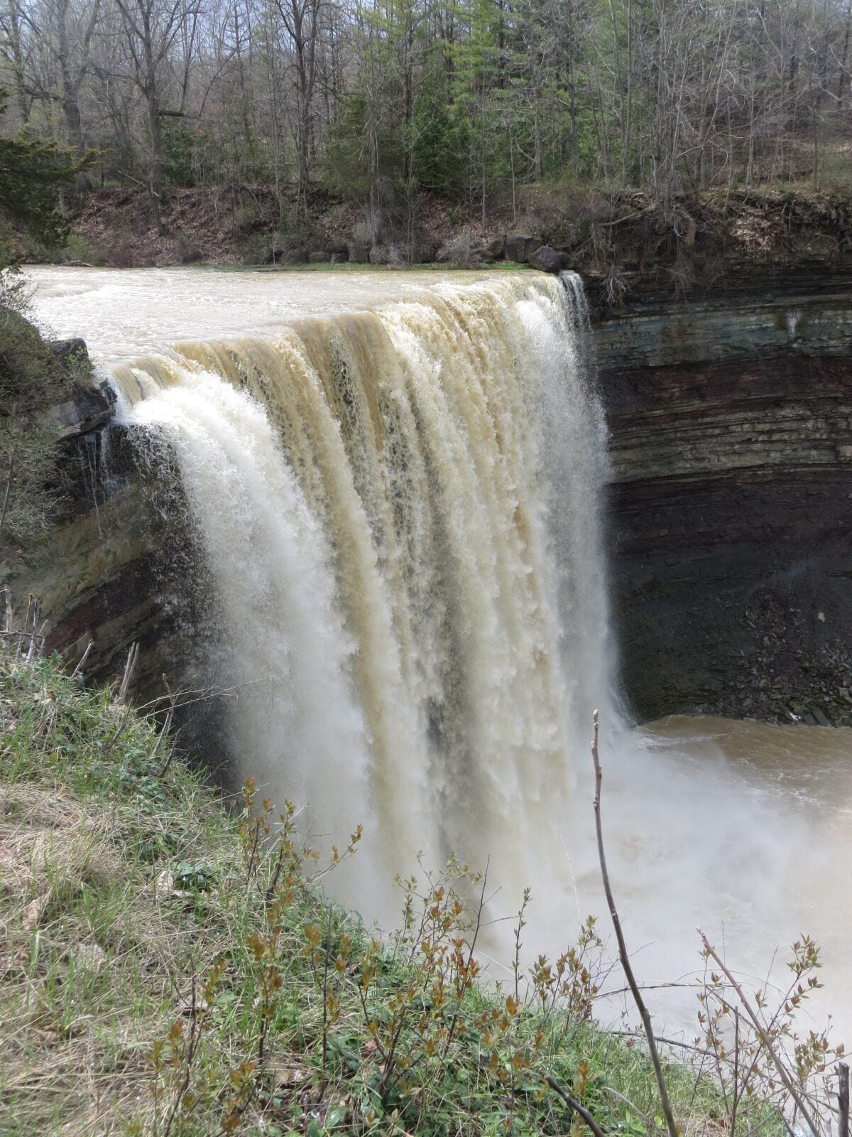
Join us for a hike and enjoy beautiful waterfalls in the Niagara region. We’ll start at Louth Conservation Area, looping around side trails and a falls along Sixteen Mile Creek. Next, we’ll pass by Louth Falls before we continue along the main Bruce Trail to Ball’s Falls. There, we’ll take in the spectacular sights of the lower falls (11 metres high) and upper falls (27 metres high). Our route is covered on Bruce Trail Maps #3 and 4.There are a few uphill climbs, including one up a 121-step staircase to reach Ball’s Falls. A 1.8-km stretch of road walking is also involved.
The total hike distance is approximately 11 km, and there will be a dropout point after approximately 8 km. Time permitting, we will have a refreshment stop in Grimsby.
It is springtime, so wet and muddy trail conditions are possible. Hiking boots, poles, and gaiters are recommended.
Sydenham E2E hike 6 of 7
https://hikes.brucetrail.org/event/car-hike-sydenham-e2e-hike-6-of-7/Sorry, the registration cut-off time for this hike has been reached.Not a member? Click here to join today!Hike open to BTC Members only.
Hosting Club: Toronto, Sydenham
Category: Car Hike
Location (Google Maps):Same location as day 5.
Hike Leader(s): Smadar Junkin Click here to contact Hike Leader(s)
Pace: Brisk (4-5 km/hr)
Terrain: Challenging, Level 3 (Advanced – steep hills and some scrambling over boulders), Variable
Distance (km): 23 kmDescription
We will shuttle to km 148.5 and walk back. We will walk about 22 kms. If you need to get in touch with me, use the “Contact Hike Leader” Dialogue Box to send a message. Bring 2 litres of water, food. Be in the meeting place 15 minutes early.Urban Walk: Leslie Street Spit Bird Watching
https://hikes.brucetrail.org/event/urban-walk-leslie-street-spit-bird-watching-3/Sorry, the registration cut-off time for this hike has been reached.Not a member? Click here to join today!Hosting Club: Toronto
Category: Urban Walk
Location (Google Maps):Entrance to Tommy Thompson Park at Leslie St and Unwin Ave.
Hike Leader(s): Ray Berzins Click here to contact Hike Leader(s)
Pace: Leisurely (2-3 km/hr)
Terrain: Flat
Distance (km): 7 kmDescription
Expect an email by 8AM on Day of Hike to check if hike is Cancelled due to bad weather.For first 3.5 km we will try to observe as much as possible along natural footpaths, so wear long pants, long stockings and whatever else will protect you from ticks. Bring binoculars. After lunch the nature walk will end and hikers can use the Multi-use Trail to continue walking to the end of the spit or return back to the park entrance by 2PM. It will be cooler and more windy than inland so bring warm clothing and a warm beverage with your lunch.