Join us for a hike! Registration required:
All hikes available to BTC members. Some hikes are open to non-members.
TIP: The calendar view displays up to 7 hikes on a day, but often there are more. Click “More events” to see them all.
Toronto Hike Schedule
Toronto Bruce Trail Club Registration Live Dates
Day Winter Coach Program
Registration begins two weeks in advance of the event departure (at 8:00 PM)
Day Bus Hikes
Registration begins two weeks in advance of the event departure (at 8:00 PM) with some exceptions of special event hikes
Day Coach Hikes
Registration begins 7 weeks in advance of the event departure
Day Car Hikes and Urban Hikes
Registration begins two weeks in advance of the event departure
Overnight and Weekend Trips
Registration begins 12 weeks in advance of the event departure
To view all Bruce Trail Conservancy Hikes click here
- 23June 23, 2024
TBTC Volunteer Appreciation Day Hike (For TBTC Volunteers Only)
https://hikes.brucetrail.org/event/tbtc-volunteer-appreciation-day-hike-for-tbtc-volunteers-only/Sorry, the registration cut-off time for this hike has been reached.Not a member? Click here to join today!Hosting Club: Toronto
Category: TBTC Special Events
Location (Google Maps): Terra Cotta Conservation Area. TBTC Volunteers who wish to join the hike please meet at our reserved Picnic Area (Picnic Area #1) for a 10:30 AM departure time.
There is no on-line registration for the hike – just meet us at Picnic Area #1 before 10:30 Am where we are having the Volunteer Appreciation Event and sign in.Hike Leader(s): Tom Swales Click here to contact Hike Leader(s)
Pace: Moderate
Terrain: Flat
Distance: 5 kmDescription
This is a short leisurely to moderate hike for Toronto Bruce Trail Club Volunteers attending our annual Volunteer Appreciation Day Event at Terra Cotta Conservation Area. Before lunch and group activities we will hike the McGregor Spring Trail, Vaughan Trail and Terra Cotta Lane trail in a circular route around Wolf Lake to return to our group picnc site for lunch, activites, and mix and mingle with fellow volunteers and TBTC Board Members.This hike is part of the TBTC’s Volunteer Appreciation Day Event to thank our dedicated volunteers for their service.
The TBTC hiking program will be paused this day so the board can thank our hike leaders. Our member’s understanding is appreciated.
- 24June 24, 2024No events
- 25June 25, 2024No events
- 26June 26, 2024No events
- 27June 27, 2024

Urban Walk: Toronto Islands Evening Walk
https://hikes.brucetrail.org/event/urban-walk-toronto-islands-evening-walk-9/Sorry, the registration cut-off time for this hike has been reached.Not a member? Click here to join today!Hosting Club: Toronto
Location (Google Maps): Jack Layton Ferry Terminal, near the gates to Wards Island Ferry. Arrive 20 minutes prior to departure to check in with hike leader.
From Union Station take the LRT and get off at the stop Ferry Docks.Walk up to the Ferry Docks on Queens Quay West, street level. at the foot of Bay Street.
Hike Leader(s): Miriam Stevens Click here to contact Hike Leader(s)
Pace: Leisurely
Terrain: Flat
Distance: 6-9 kmDescription
After a day’s work come and “cool off” on the Toronto Islands free of fumes and traffic. Enjoy the view of the city skyline and Toronto’s beautiful island parkland.
Pack a dinner for a sit down picnic. Food is not available for purchase on the Islands early in the season. Also bring a warm jacket and flashlight.
Return fare ticket for the ferry $9.11, $5.86 for seniors.
Hikes will take place rain or shine.
Toronto Island evening hikes will take place every THURSDAY in MAY and JUNE 2024.
Same time and same meeting place. No preregistration is required – just show up at the ferry docks at 5:40 PM and sign with the hike leader. - 28June 28, 2024
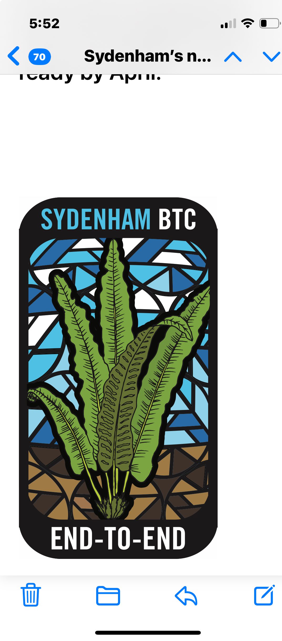
Sydenham Fundraising E2E in 8 hikes
https://hikes.brucetrail.org/event/sydenham-fundraising-e2e-in-8-hikes/Sorry, the registration cut-off time for this hike has been reached.Not a member? Click here to join today!Hike open to BTC Members only.
This is a Multi-Day Hike
You are signing up for the following dates and times:
2024-06-28 at 08:30
2024-06-29 at 08:30
2024-06-30 at 08:30
2024-07-01 at 08:30
2024-07-05 at 08:30
2024-07-06 at 08:30
2024-07-07 at 08:30
2024-07-08 at 08:30Hosting Club: Toronto, Sydenham
Category: Car Hike
Location (Google Maps): Km 20.7, shoulders of 6th concession S. coordinates N 44.507399, 80.810098 map 29Hike Leader(s): Smadar Junkin Click here to contact Hike Leader(s)
Pace: Brisk
Terrain: Challenging, Variable
Distance: 20.7kmDescription
Welcome to the Fundraising hike series of the Sydenham. These funds will be collected by the Toronto Bruce Trail Club and will be transferred to the Sydenham Club to help with the club’s expenses and the pledge of maintaining The Ribbon Of Wilderness For Everyone Forever.
the hike cost will earn the participants the Stained glass badge of the Hart Tongue Fern.
You are registering for all 8 hikes and expected to hike all 8. However, you will be allowed to miss two hikes and make it up on your own.we will shuttle to km 0.0 and walk back.
We will leave no trace of being on the trail and try to leave the trail in better shape then before we get there.
hikers will receive an email with the meeting locations for each hike.
the pace expectation is 4- 4.5 km per hour. Please arrive 15 minutes early so the shuttle can leave by 8:30. All participants are expected to take part in the shuttles during the 8 hiking days.bring two litres of water. Bug repellent.
- 29June 29, 2024

Mulmur and Boyne Valley Provincial Park
https://hikes.brucetrail.org/event/mulmur-and-boyne-valley-provincial-park/Sorry, the registration cut-off time for this hike has been reached.Not a member? Click here to join today!Trip Information
Departure Time: 08:00
Return to City Time: 18:00
Departure Point: York Mills Bus PickupOptional Items
Major Mackenzie and 400 Park and Ride Parking lot ($0.01)Hosting Club: Toronto, Dufferin Hi-Land
Category: Bus Hike
Location (Google Maps): Boyne Valley Provincial Park and Mulmur (map 20)Hike Leader(s): Amir Alemohammad, Mohammad Aghamiri, Mehrnoush Ahmadi Click here to contact Hike Leader(s)
Pace: Moderate (3-4 km/hr)
Terrain: Variable
Distance: 16-18 kmDescription
Bus departs 10 York Mills Rd at 8:00 AM and Major Mackenzie Dr and HWY 400 Park and Ride at 8:30 AM. If you wish to be picked up at the Major Mackenzie Dr and HWY 400 Park and Ride, type ‘yes’ in the additional information field. Please arrive 15 minutes before departure. The bus waits for no oneThis is a fantastic hike to explore Mulmur and the Boyne Valley provincial park. Entering from 10 Sideroad (Road 17) into the main trail (km 30.5, Map 20) we will go south to enter the Boyne Valley on km 20.6. Beautiful side trails, some lookouts and creeks are along the way including Murphy’s Pinnacle Lookout point and Mulmur Lookout side trail. The Boyne valley is always a piece of gem in the Bruce trail. We will end up in the Primrose Bruce Trail parking lot. Drop outs at Km 23.9, 20.6 and First Line E Rd. Please dress according to weather conditions. Boots mandatory poles recommended. Bring at least 4 lit of water, snacks/lunch and be prepared for bugs. Access to the bus is available on the drop out locations. We will have frequent stops to have water and bio breaks and also a 30 min stop for lunch. On the way back we will have a short stop at the nearby local burger shop for refreshments, if there is enough time. We will be back to the York Mills Bus stop by 6:00 pm. We love pets but they are not allowed in this hike.
Car Hike: Hike the Main Trail from Limehouse CA to Speyside Resource Management Area
https://hikes.brucetrail.org/event/car-hike-hike-the-main-trail-north-of-limehouse-ca-to-speyside-resource-management-area/Sorry, the registration cut-off time for this hike has been reached.Not a member? Click here to join today!Hosting Club: Toronto
Category: Car Hike
Location (Google Maps): Meeting Location: Roadside parking at Limehouse at the intersection of 22 Sideroad and Fifth Line. Please do not block driveway or access to the bridge. GPS N43.636859, W-79.979818. Map 12Hike Leader(s): Ross Estrella Click here to contact Hike Leader(s)
Pace: Brisk, Moderate
Terrain: Hilly, Rocky, Variable
Distance: 14 kmsDescription
We will hike the main trail from Limehouse Conservation Area to Speyside Resource Mangement Area. We’ll make this outing a (Hike4Health-Hike4Fun) which allowed us ample time for fun activities and photograhy of the sceneries that catches our eyes along the way. Please bring snacks, lunch and enough water for hydration. Make handy of sunscreen, sun head protection and bug spray as we may be greeted by our friendly mosquitoes. Comfortable/sturdy hiking shoe/boot and poles are strongly recommended. Check weather forecast and dress accordingly. Strongly suggest to bring your personal medication and health ID. Please arrive fifteen minutes early to allow for car shuttling. No drop out allowed.Car Hike: Happy Valley - CANCELLED
https://hikes.brucetrail.org/event/car-hike-happy-valley-3/Sorry, the registration cut-off time for this hike has been reached.Not a member? Click here to join today!Hosting Club: Toronto
Location (Google Maps): Happy Valley, Oak Ridges Trail 16th Sideroad and Weston Road
Hike Leader(s): Mohammad Aghamiri Click here to contact Hike Leader(s)
Pace: Moderate
Terrain: Variable
Distance: 14-17 kmDescription
Come and join the group to view nice sceneries and look out of Happy valleySome safety procedures during the hike:
1-Hikers must stay between the leader and the sweep.
2-Hikers must advise the leader or the sweep if they wish to leave the group.
3- Hikers must follow the whistle instructions: 1 blast- stay where you are; 2 blasts come to the leader; 3 blasts – come to the leader quickly.
4-Hike leader may request volunteers to stop at trail intersections, they need to help hikers to the direction the group walk and wait till they see the sweep .
5-Hikers have to make sure they can see the persons behind and in front of them.
Car Hike: Bethesda Trail Richmond Hill
https://hikes.brucetrail.org/event/car-hike-bethesda-trail-richmond-hill-28/Sorry, the registration cut-off time for this hike has been reached.Not a member? Click here to join today!Hosting Club: Toronto
Location (Google Maps): Free parking lot at the head of trail Bethesda Side Road off Bayview Ave. across Wilcox lake
Hike Leader(s): Mohammad Aghamiri Click here to contact Hike Leader(s)
Pace: Moderate (3-4 km/hr)
Terrain: Hilly, Level 2 (Intermediate – some hills and uneven surfaces, rocks and roots underfoot)
Distance: 14-15 kmDescription
Join us to explore the trails of York Regional Forest and the Oak Ridges Corridor at Jefferson Forest and Bond lake,From parking lot we hike thought Jefferson forest and continue to Bond Lake and have snack beside the lake and return to parking around 13 to 13.30