Categories
- 14June 14, 2026
Cancelled - Peninsula BT Makeup Hike (km 117.8 – km 139.5)
https://hikes.brucetrail.org/event/peninsula-bt-makeup-hike-km-117-8-km-139-5-2/Sorry, the registration cut-off time for this hike has been reached.Not a member? Click here to join today!Hosting Club: Peninsula
Category: Peninsula BT Makeup Hike
Location (Google Maps):Hike Leader(s): Kathleen Stahlbaum & Saabir Sohrab Click here to contact Hike Leader(s)
Pace: Medium (3.0 – 4.5 km/h): A comfortable pace for most hikers with steady progress.
Terrain: Difficult: Steep ascents/descents, rocky scrambling, and some rugged escarpment paths.
Distance: ~26.6Description
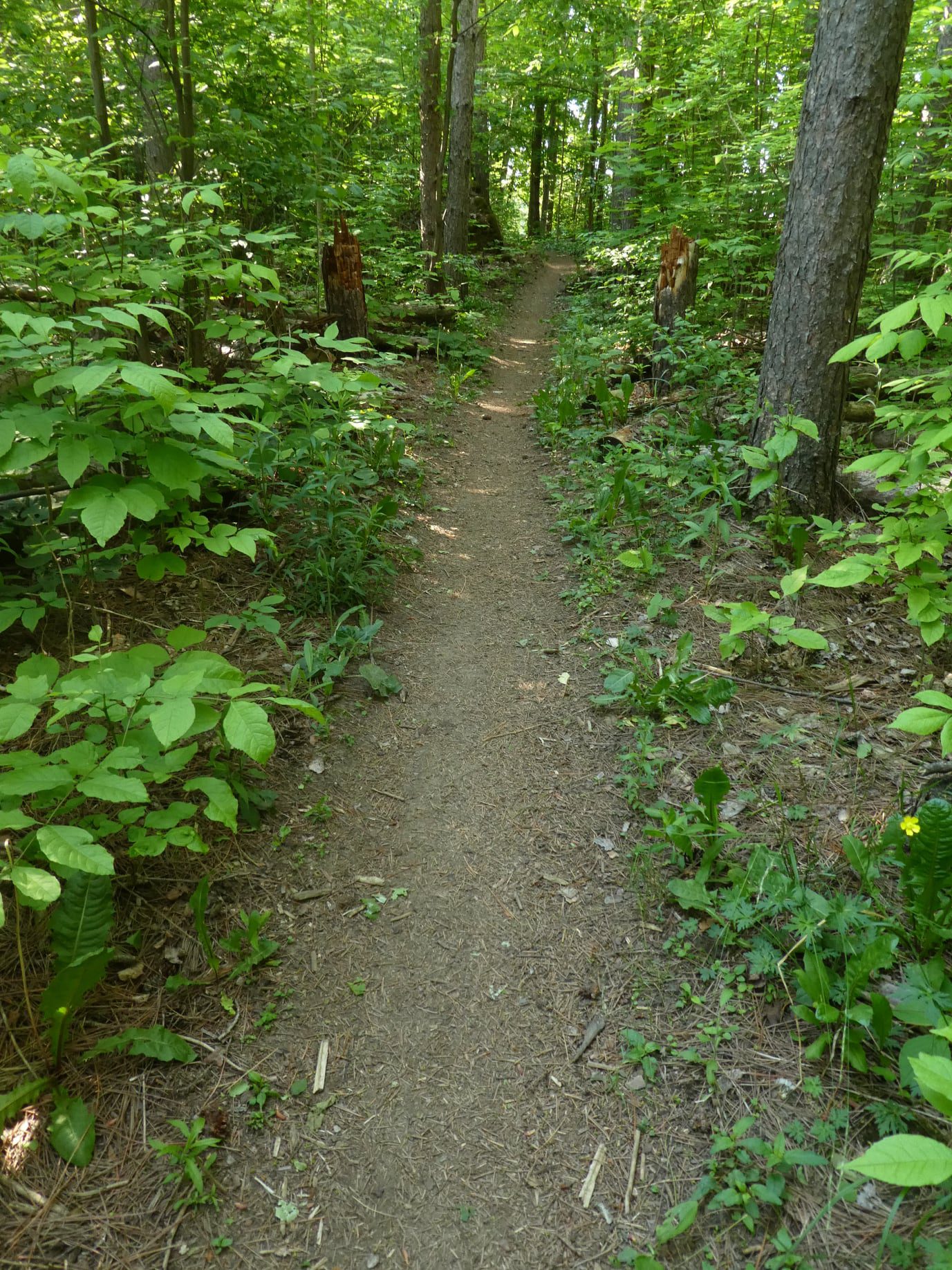
Lindsay Rd 40 to Halfway Log dumpThis hike is part of the Peninsula BT Makeup Hikes, intended for hikers completing missed sections of the Peninsula Bruce Trail. Each hike requires individual registration.
To hike the entire Peninsula Section, please register for the Full Peninsula End-to-End Series (single registration for all 10 hikes): https://hikes.brucetrail.org/event/peninsula-end2end-in-10-series/2026-05-01/
Hikers may register for all 10 Makeup Hikes if they wish.
Expectations: Expect ~9 hours on the trail, depending on the terrain, weather, and group pace. The hike leader sets the pace, aiming for 3–4 km/h, and may adjust as needed for group ability and trail conditions. Breaks will be taken throughout the day.
For safety, participants must remain between the hike leader and the hike sweep at all times.
Fees:
- Registration fee does not include Bruce Peninsula National Park entry fees and parking fees
- Fundraising: This hike is a fundraiser to support the Peninsula Bruce Trail Club’s volunteer-run hike program.
Participant Requirements
- Intermediate/experienced hikers with good fitness
- Proper hiking boots, layered clothing, wet weather gear
- Hiking poles recommended
- Bring: Lunch, snacks, water, bug spray
Transportation & Accommodations
- Car shuttle: Participants rotate as drivers; vehicles must be passenger-ready
- Accommodations: Book early; options include motels, campgrounds, hostels, and B&Bs
Note: Dogs are not permitted.

Car Hike: Jefferson Forest/Bond Lake
https://hikes.brucetrail.org/event/car-hike-jefferson-forest-bond-lake/Sorry, the registration cut-off time for this hike has been reached.Not a member? Click here to join today!Hosting Club: Toronto
Category: Car Hike
Location (Google Maps):1245 Bethesda Side Rd, Richmond Hill, ON L4E 1A2 ( Bethesda Trail Head Parking lot)
Hike Leader(s): Amir Alemohammad Click here to contact Hike Leader(s)
Pace: Moderate (3-4 km/hr)
Terrain: Flat, Hilly, Level 2 (Intermediate – some hills and uneven surfaces, rocks and roots underfoot), Variable
Distance (km): 15-16 kmDescription
Let’s roll the hills of the Jefferson Forest and around the Bond Lake. Every week we hike in Jefferson Forest, located in the heart of Richmond Hill, it boasts numerous hiking trails. This 3.5 hour hike can range from 14 to 15 kilometres, depending on the weather conditions. Remember to bring water, snacks, hiking boots, poles, and your camera. Not recommended for beginners. Park in the free Bethesda parking lot and avoid parking along the road. Dress appropriately for the weather. Difficulty Level: 2 (Moderate).Please arrive @7:45AM for start of 8:00AM.
This is a joint hike with the Oak Ridges Trail Association (ORTA).
what3words:
https://w3w.co/twisting.mailer.awakes
Sunny Sundays - Maple Lane to Loree Forest and return
https://hikes.brucetrail.org/event/sunny-sundays-maple-lane-to-loree-forest-and-return/Sorry, the registration cut-off time for this hike has been reached.Not a member? Click here to join today!Hosting Club: Beaver Valley
Location (Google Maps): Meet at the east end of Maple Lane, park on the north side of the street, Map 24, Edition 30, check Google Maps in hike listing for coordinates
Hike Leader(s): Mike Arkless Click here to contact the hike leader.
Pace: Medium
Terrain: Moderate, Some rocky footing, Some steep sections
Length of Hike: 14.3 kmDescription
We will hike from Maple Lane to reach the Loree Forest Loop, hike on to the Loree side Trail then return to our cars on the main trail. We’ll be above the ski hills, with views of Nottawasaga Bay before we head down to the Loree Forest Side Trail and over a lovely creek. Please ensure you arrive at 8:15 a.m for an 8:30 a.m. start. Bring water and snacks. We’ll have a couple of short breaks and a mid hike break for snacks. Dress appropriately for the weather and trail conditions. Bring sunscreen and insect repellent or protective covering like a bug hat and long sleeves. You can use the “Click here to contact the hike leader” option in the hike listing if you have any questions.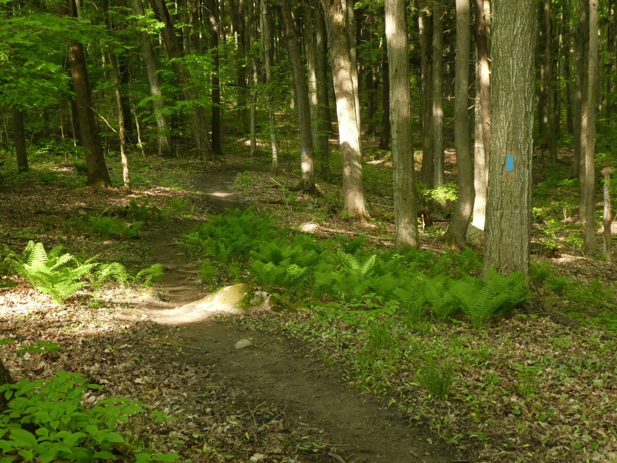
CANCELLED - Glen Cross to Riverside Woods
https://hikes.brucetrail.org/event/glen-cross-to-riverside-woods/Sorry, the registration cut-off time for this hike has been reached.Not a member? Click here to join today!Hosting Club: Iroquoia
Category: General Hike
Location (Google Maps): Meet roadside at 9:15 on Second Line, south of Hockley Valley.Hike Leader(s): Karen Bergmann Click here to contact Hike Leader(s)
Pace: Medium – 3 to 4 km/hr
Terrain: Moderate – Some hills and/or some poor footing
Distance: 9 kmsDescription
Meeting roadside at 9:15 on Second Line, we will carpool to Fourth Line and hike back. The trail takes us through the forest and the grounds of the Hockley Valley Resort, across a golf course and bike trails, down to Second Line. We will continue into Riverside Woods and hike a loop along the side trails there, back to the cars.Bring sufficient water and a snack, as needed, as well as bug spray/bug net.
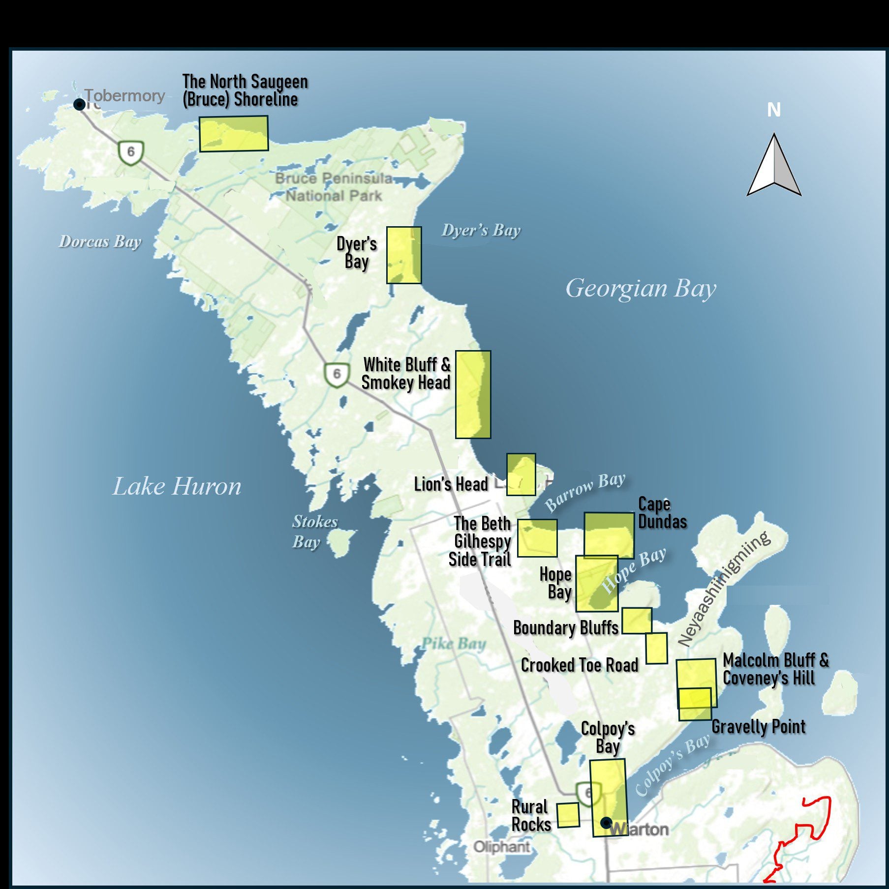
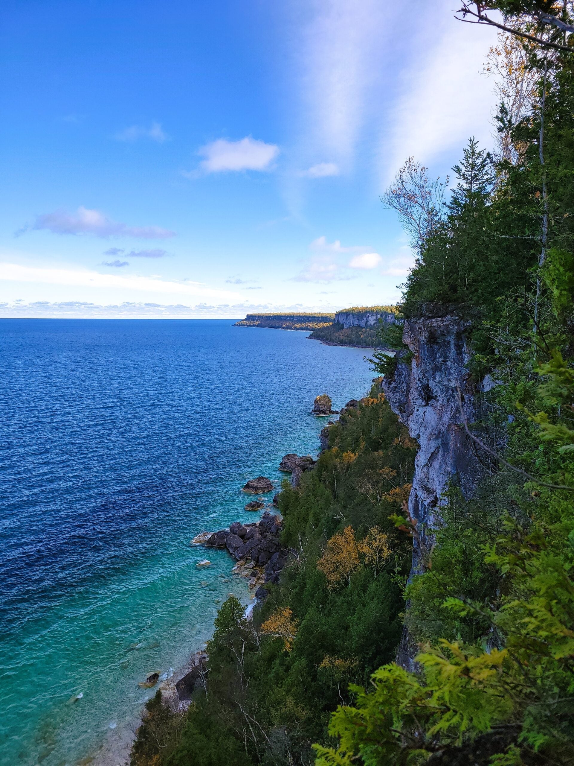
Geology Hike and Badge Series - Boundary Bluffs
https://hikes.brucetrail.org/event/geology-hike-and-badge-series-boundary-bluffs/Sorry, the registration cut-off time for this hike has been reached.Not a member? Click here to join today!Hosting Club: Peninsula
Category: Geology Hike
Location (Google Maps): Boundary BluffsHike Leader(s): Beth Gilhespy Click here to contact Hike Leader(s)
Pace: Leisurely (2.0 – 3.0 km/h): A relaxed pace with frequent breaks and a focus on enjoyment.
Terrain: Moderate: Rolling hills, mild slopes and rocky paths.
Distance: 5.2Description
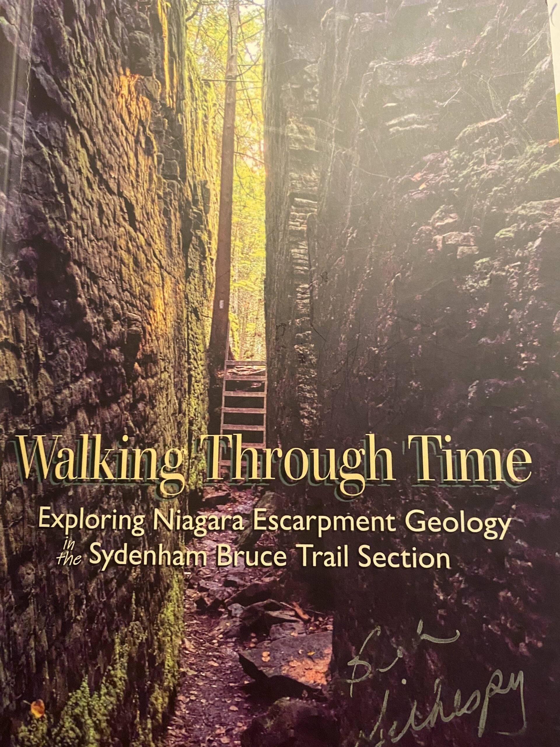
Join the adventure and earn the inaugural Peninsula Geology Badge! Over a stretch of 13 hikes and a couple of extra stops, we will explore the fascinating geology of the Peninsula to learn about the rocks, the shoreline features, glaciation, fossils and all things earthy. The 13 hikes are from the book “Walking Through Time – Exploring the Geology of the Saugeen (Bruce) Peninsula”. Having a copy will give you a lot of great information, but you do not have to purchase the book to attend and enjoy the hikes. Just bring your curiosity! We will make sure to hit all the locations that qualify for the beautiful new Walking Through Time – Saugeen (Bruce) Peninsula geology hike badge. If you would like to purchase a book I will have some available on the hikes, or you can pick one up from the BTC Head Office, at Ginger Press in Owen Sound, Suntrail Source for Adventure in Hepworth, the Shop at 84 Main in Lion’s Head and at Reader’s Haven in Tobermory.You are welcome to come on just a few of the hikes or on all of them, and the dates and hikes are as follows:
Date Geology Hike km
Saturday May 2, 2026 Colpoy’s Bay 9.0
Saturday May 9, 2026 Gravelly Point (am) and Rural Rocks (pm) 8.6
Saturday May 16, 2026 Malcolm Bluff 7.3
Sunday May 17, 2026 White Bluff/Smokey Head 11.8
Sunday May 24, 2026 Crooked Toe Road 5.5
Sunday May 31, 2026 Hope Bay 8.1
Sunday June 14, 2026 Boundary Bluffs 5.2
Saturday July 4, 2026 Cape Dundas 6.2
Saturday July 11, 2026 Beth Gilhespy Side Trail 7.6
Saturday August 8, 2026 Lion’s Head 11.0
Saturday August 15, 2026 Dyer’s Bay Loops 7.5
Saturday August 22, 2026 North Saugeen (Bruce) Shoreline 8.0
Meeting times will vary depending on the hike, but will generally be some time between 9 am and 10 am. Information on exact meeting times and locations will be sent out a few days prior to the hike.
Pre-Film Fundraiser Hike
https://hikes.brucetrail.org/event/pre-film-fundraiser-hike/Sorry, the registration cut-off time for this hike has been reached.Not a member? Click here to join today!Hosting Club: Caledon Hills
Category: General
Location (Google Maps): Parking Lot beside the Guelph Lawn Bowling Club.
Loop hike around the Eramosa River, mostly flat, shaded, with some interesting points of interest.Hike Leader(s): Ralph Shapiro Click here to contact Hike Leader(s)
Pace: Leisurely – 3 km/hour or less
Terrain: Moderate – some hills and/or some poor footing
Distance: 5 kilometers more or lessDescription
Side trail Challenge # 6
https://hikes.brucetrail.org/event/side-trail-challenge-6/Sorry, the registration cut-off time for this hike has been reached.Not a member? Click here to join today!Hosting Club: Niagara
Category: Loop
Location (Google Maps): Shorthills Wiley RdHike Leader(s): Heather Howkins Click here to contact Hike Leader(s)
Pace: Brisk
Terrain: Moderate
Distance: 12.2Description
#6 of the side trail Challenge –We will meet at Wiley Rd parking lot and hike 3 side trails to complete this leg of the challenge :
Morning Star, Black Walnut and Rim of Africa.
photos needed Morning Star Mill, Decew Falls and Terrace Falls
Please bring water, snacks and poles.
Toronto Urban Badge Hike - 7/7
https://hikes.brucetrail.org/event/urban-walk-toronto-urban-badge-hike-7-of-7-4/Sorry, the registration cut-off time for this hike has been reached.Not a member? Click here to join today!Hosting Club: Toronto
Category: Urban Walk
Location (Google Maps): East Don TrailHike Leader(s): Brian Rideout Click here to contact Hike Leader(s)
Pace: Moderate (3-4 km/hr)
Terrain: Flat
Distance (km): 9 kmDescription
Please join me at the south east corner of Overlea Blvd and Don Mills Rd by 10 AM. We will hike south on the Don Trail to the Distillery District (km 62.4 to km 71.4). Here is an online map with km markings of our route for all 7 hikes for the Toronto Urban Badge: https://onthegomap.com/s/c2c1hf3nPlease make sure you bring at least 2 liters of water, a lunch, bug spray and sunscreen.
Urban Walk: Bluffers Park
https://hikes.brucetrail.org/event/urban-walk-bluffers-park-4/Sorry, the registration cut-off time for this hike has been reached.Not a member? Click here to join today!Hosting Club: Toronto
Category: Urban Walk
Location (Google Maps):Bluffer’s Park, Scarborough
Hike Leader(s): Tom Swales Click here to contact Hike Leader(s)
Pace: Moderate (3-4 km/hr)
Terrain: Flat, Level 1 (Easy – mostly on flat, well maintained trails with hard-packed surface)
Distance (km): 7 kmDescription
Enjoy the scenic views of the cliffs at Scarborough’s Bluffers Park and hike along the beach to the east. Meet at Kennedy Station on the bus platform for Route #201 Bluffers Park at 10:00 to take the bus scheduled to depart at 10:15 AM to arrive at the park approximately 20 minutes later. Taking transit is strongly recommended as the park gets very busy on the weekends. (free parking is available at Kennedy Station).
POSTPONED: GeoHike - Ball's Falls Conservation Area
https://hikes.brucetrail.org/event/geohike-balls-falls-conservation-area/Sorry, the registration cut-off time for this hike has been reached.Not a member? Click here to join today!Hike open to BTC Members only.
Hosting Club: Niagara
Category: Geology
Location (Google Maps): 3292 Sixth Avenue, Lincoln, ONHike Leader(s): Kristin Hanson Click here to contact Hike Leader(s)
Pace: Leisurely <3 km/hr
Terrain: Easy: mostly flat, good footing
Distance: 2.0Description
POSTPONED DUE TO WEATHER. Look at 438 million years of geologic history and discover why early settlers chose Balls Falls to establish their industrial base. Learn about the formation of the Niagara Escarpment, how glaciation contributed to formation of the valleys and waterfalls, and how the landscape continues to change. We will depart from the Ball’s Falls visitor center – meet at the GeoPoint sign just east of the main doors. We will then follow the short Switchback Trail down into the valley and take the Cataract Trail to the Upper Falls. We will hike along Twenty Mile Creek as it makes its way over the Niagara Escarpment into the Village and get a great view of the Lower Falls. We will use a slow pace and stop and discuss geology along the way. It will only take us 1 hour to cover the distance. When we arrive at the Lower Falls we will stop to enjoy it, so bring a snack. There are washrooms near the village. We will return to the parking lot and visitor center, where there are washrooms and water fountains.Note there is an entrance/parking fee of $15per car but a NPCA parking pass covers this fee; passes may be available to checkout from local libraries
Exploring Sydenham Hike #41 Maple Cross Ridge
https://hikes.brucetrail.org/event/exploring-sydenham-hike-41-maple-cross-ridge/Sorry, the registration cut-off time for this hike has been reached.Not a member? Click here to join today!Hosting Club: Sydenham
Category: General Hike
Location (Google Maps):We will carpool from 2888 3rd Ave. W., Owen Sound
Hike Leader(s): Bill Snel Click here to contact Hike Leader(s)
Pace: Leisurely: 3 km/h or less
Terrain: Moderate: Some hills and/or poor footing, There might be muddy sections., There might be sections with water on the trail.
Distance: 6 kmDescription
We will carpool from Owen Sound to do a loop hike of the Maple Cross Ridge side trail. This is hike 41 in the book Exploring Sydenham. There will be one secret to find. If you do not have a book and would like one ($30) let me know by using the “Contact hike leader” link. - 15June 15, 2026

Fabulous Fen Flora!
https://hikes.brucetrail.org/event/fabulous-fen-flora/Sorry, the registration cut-off time for this hike has been reached.Not a member? Click here to join today!Hosting Club: Peninsula
Category: Botany Hike
Location (Google Maps): Petrel Point Nature ReserveHike Leader(s): Marg Glendon Click here to contact Hike Leader(s)
Pace: Leisurely (2.0 – 3.0 km/h): A relaxed pace with frequent breaks and a focus on enjoyment.
Terrain: Easy: Flat forested sections or lowland trails.
Distance: ~2 kmDescription
Explore Nature’s Garden of Wildflowers and Orchids with Nature Conservancy Canada’s (NCC) Jacob Kloeze, Acting Program Director Midwestern Ontario and Alex Duszczyszyn, Assistant Conservation Biologist at Ontario Nature’s Petrel Point Nature Reserve on Monday, June 15th. Rain date – Tuesday, June 16th.This pretty nature reserve managed by Ontario Nature is home to many native wildflowers, orchids, ferns and carnivorous plants. Due to the unique conditions in this Great Lakes Coastal Meadow Marsh, special plants have adapted to live in this environment. Learn about the characteristics of this ecosystem and how these plants depend on it for survival.
Several orchid and fern species thrive here. During this hike you will learn about orchid viewing etiquette, definition of an orchid and our responsibility to protect them. Observations on this hike, will qualify toward earning the PBTC Orchid and Fern badges: https://pbtc.ca/badges/
John Grandy, neighbour and local conservationist will also join us to share historical highlights of this unique property.
This “walk-and-talk” hike is a loop hike meandering through the nature reserve on terrain which is generally flat, mostly boardwalk with some natural, uneven forest hiking trail. Boardwalks can be slippery when wet. Be prepared to walk approximately 2 km. Hike duration will be about 1 ½ -2 hours.
Please bring a light back pack with snacks and water. Wear a hat, long-sleeved sun protective clothing, and sturdy hiking boots. Be prepared for flying insects. Bring a net hat and insect repellent.
Bring binoculars and/or a camera. If planning to post photos or using your I-Naturalist app, please turn off your location identifiers.
If you have reference sheets or books – bring them along. Excellent local references include the Orchids of Bruce Grey and Ferns of Bruce Grey County, available through Owen Sound Field Naturalists. You may also want to view the BTC webinar Spring Ephemerals: https://brucetrail.org/events/#webinars .
If you wish to linger longer, there are a few benches placed along the boardwalk.
Thank you to Ontario Nature for protecting this beautiful nature reserve
EASY DOES IT HIKE, St Catharines Museum & Welland Canals Centre
https://hikes.brucetrail.org/event/easy-does-it-hike-st-catharines-museum-welland-canals-centre/Sorry, the registration cut-off time for this hike has been reached.Not a member? Click here to join today!Hosting Club: Niagara
Category: Leisurely
Location (Google Maps): 1932 Welland Canals Parkway, Lock 3, St. CatharinesHike Leader(s): Diane Marlatt Click here to contact Hike Leader(s)
Pace: Leisurely <3 km/hr
Terrain: Easy: mostly flat, good footing
Distance: 4 KmDescription

GeoHike - Ball's Falls Conservation Area
https://hikes.brucetrail.org/event/geohike-balls-falls-conservation-area-2/Sorry, the registration cut-off time for this hike has been reached.Not a member? Click here to join today!Hosting Club: Niagara
Category: Geology
Location (Google Maps):3292 Sixth Avenue, Lincoln, ON
Hike Leader(s): Kristin Hanson Click here to contact Hike Leader(s)
Pace: Leisurely <3 km/hr
Terrain: Easy: mostly flat, good footing
Distance: 2.0Description
Look at 438 million years of geologic history and discover why early settlers chose Balls Falls to establish their industrial base. Learn about the formation of the Niagara Escarpment, how glaciation contributed to formation of the valleys and waterfalls, and how the landscape continues to change. We will depart from the Ball’s Falls visitor center – meet at the GeoPoint sign just east of the main doors. We will then follow the short Switchback Trail down into the valley and take the Cataract Trail to the Upper Falls. We will hike along Twenty Mile Creek as it makes its way over the Niagara Escarpment into the Village and get a great view of the Lower Falls. We will use a slow pace and stop and discuss geology along the way. It will only take us 1 hour to cover the distance. When we arrive at the Lower Falls we will stop to enjoy it, so bring a snack. There are washrooms near the village. We will return to the parking lot and visitor center, where there are washrooms and water fountains.Note there is an entrance/parking fee of $15per car but a NPCA parking pass covers this fee; passes may be available to checkout from local libraries
- 16June 16, 2026
Long Haulers Hike NEW TIME NEW LOCATION
https://hikes.brucetrail.org/event/long-haulers-hike-new-time-new-location-5/Sorry, the registration cut-off time for this hike has been reached.Not a member? Click here to join today!Hosting Club: Niagara
Location (Google Maps): Short Hills Wiley Road, Thorold
Pace: Fast 5+ km/hr
Terrain: Moderate: some hills and some poor footing
: 10k+Description
Back to our regular Spot for the Tuesday Long Hike. Note the new location. We will hike the trails around Short Hills Dress for the weather and bring sunscreen bug spray, poles snack and drinkSilver Creek- 10h line
https://hikes.brucetrail.org/event/silver-creek-10h-line/Sorry, the registration cut-off time for this hike has been reached.Not a member? Click here to join today!Hosting Club: Dufferin Hi-Land
Category: Tuesday Hike
Location (Google Maps):Toronto Section, Map 13, Meet at Km 38. 8 on 10th line , 2.2 km south of 32 sideroad
Hike Leader(s): Inge Eckerich, Les Babbage, Julie Daley, Tony Evangelista Click here to contact Hike Leader(s)
Pace: Leisurely
Terrain: Moderate
Distance: 5.5 kmDescription
We will hike the main trail to km 36.2 and return by the Roberts side trail and main trail9:15 Short hike, Short Hills Park, Pelham Road
https://hikes.brucetrail.org/event/915-short-hike-short-hills-park-pelham-road-3/Sorry, the registration cut-off time for this hike has been reached.Not a member? Click here to join today!Hike open to BTC Members only.
Hosting Club: Niagara
Category: In and Out
Location (Google Maps): Short Hills Provincial Park, Pelham Road entranceHike Leader(s): janet davey Click here to contact Hike Leader(s)
Pace: Medium 3- 4 km/hr
Terrain: Moderate: some hills and some poor footing
Distance: 6 kmsDescription
Hike the main and side trails of Short Hills Provincial Park. Please bring water and hiking poles. Ticks are active right now so remember to check yourself after the hike.Limehouse Loop
https://hikes.brucetrail.org/event/limehouse-loop-3/Sorry, the registration cut-off time for this hike has been reached.Not a member? Click here to join today!Hosting Club: Caledon Hills
Category: Tuesday Hikers
Location (Google Maps): Meet at Limehouse Conservation Area, west of km 20.3 at the baseball diamonds. Access from 5th Line, just southeast of the village of Limehouse.Hike Leader(s): Ralph Shapiro Click here to contact Hike Leader(s)
Pace: Medium – 3 to 4 km/hour
Terrain: Moderate – some hills and/or some poor footing
Distance: 9 kilometresDescription
Lovely loop hike using main trail and a couple of side trails.Island Lake - Orangeville
https://hikes.brucetrail.org/event/island-lake-orangeville-6/Sorry, the registration cut-off time for this hike has been reached.Not a member? Click here to join today!Hosting Club: Caledon Hills
Category: Tuesday Hikers
Location (Google Maps): Meet at Vicki Barron Lakeside Trail Parking.
After driving through Orangeville traffic lights on Highway 10, turn right on Hockley Rd., keep straight onto Sideroad 5, turn right on Hurontario Street to the car parking close to the lake.Hike Leader(s): Mohammad Shafiq Click here to contact Hike Leader(s)
Pace: Medium – 3 to 4 km/hour
Terrain: Easy – mostly flat and usually good footing
Distance: 9 – 10 kmDescription
Will hike around Island Lake, may take diversion into the side trails for a total of 9-10 km completing a loop around the lake.
Bring hydration drink and snack.
Keep sunscreen and bugs spray in your bag.Urban Walk: Valley View Park
https://hikes.brucetrail.org/event/urban-walk-valley-view-park-thornhill-177/Sorry, the registration cut-off time for this hike has been reached.Not a member? Click here to join today!Hosting Club: Toronto
Location (Google Maps): Parking lot is off Sycamore Drive, East of Bayview , across Starbucks plaza
Bus 91 from Finch East station stops at Sycamore station.Hike Leader(s): MOHAMMAD AGHAMIRI Click here to contact Hike Leader(s)
Pace: Moderate (3-4 km/hr)
Terrain: Hilly, Level 2 (Intermediate – some hills and uneven surfaces, rocks and roots underfoot)
Distance (km): 6-7 kmDescription
We will explore Valleyview and Maple View parks, and walk along German Mill Creak, in return we stop in Huntington park and have snack under beautiful shed.Although this is considered an “Urban Walk”, you can expect some hills up and down and uneven surfaces with tree roots. Please bring hiking poles, water and snacks.
Walk In Nature Series (WINS) Tuesday Summer Evenings - Pines and Clearview trails
https://hikes.brucetrail.org/event/walk-in-nature-series-wins-tuesday-summer-evenings-pines-and-clearview-trails/Sorry, the registration cut-off time for this hike has been reached.Not a member? Click here to join today!Hosting Club: Sydenham
Category: General Hike
Location (Google Maps): Click the Google Maps link to take you there. Meet and park roadside on the west side of the road on 8th Concession North, 1 km north of Hwy 26 in the former Sydenham Township. In the Bruce Trail Reference, Edition 31, meet at km 71.1 on Map 31Hike Leader(s): Stewart Brown Click here to contact Hike Leader(s)
Pace: Medium: 3 to 4 km/h
Terrain: Moderate: Some hills and/or poor footing
Distance: 5 kmDescription
Tuesday evening WINS summer hikes begin at 6:30 p.m. as a way to enjoy the daylight and nice weather of summer evenings. Join us as we loop aroung 2 adjacent side trails- the Pines Side Trail and the Clearview Side Trail. The Pines trail is level and passes through an intersting reforested pine plantation and past an old barn foundation. Clearview follows the slope of a hill to a sparkling creek and back up the hill to track along the base of the escarpment. Our hike includes a stop at the special and historic Polish Solier Tree. - 17June 17, 2026
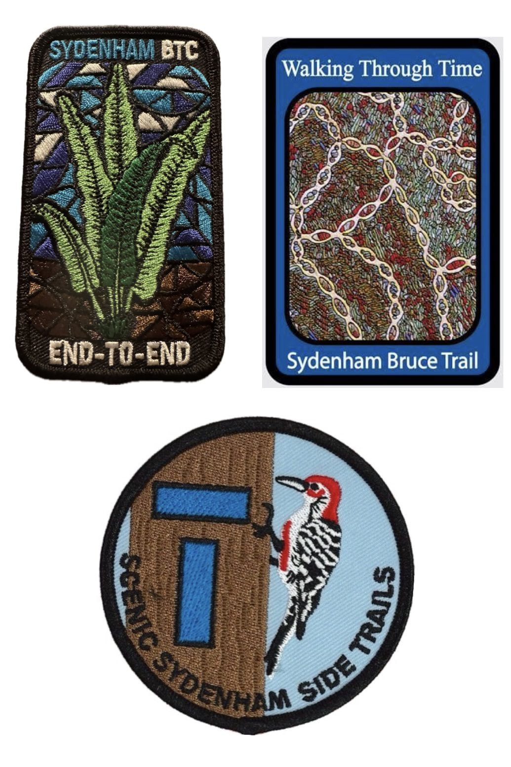
Sydenham END to END Stained Glass Fundraiser Badge plus Sydenham Side Trail Badge plus Sydenham Walking Through Time Badge - June 17, 18, 19, 20, 21, 22, and 25, 26, 27, 28, 29, 30.
https://hikes.brucetrail.org/event/sydenham-stained-glass-badge-fundraiser-sydenham-side-trail-badge-tba-and-sydenham-walking-through-time-badge-june-17-18-19-20-21-24-25-26-27-28-29-30/Sorry, the registration cut-off time for this hike has been reached.Not a member? Click here to join today!This is a Multi-Day Hike
You are signing up for the following dates and times:
2026-06-17 at 07:00
2026-06-18 at
2026-06-19 at
2026-06-20 at
2026-06-21 at
2026-06-22 at
2026-06-25 at
2026-06-26 at
2026-06-27 at
2026-06-28 at
2026-06-29 at
2026-06-30 atHosting Club: Iroquoia, Sydenham
Category: Stained Glass Badge End to End Fundraiser Hike
Location (Google Maps): Sydenham Bruce Trail Club – Stained Glass Badge; Side Trails Badge and Walking Through Time Badge – 12 day hike – (2x6days).
We are meeting in the parking lot at Blantyre on the first morning. East side of Grey Rd 12
Registered participants will receive a WhatsApp invitation (optional)which can be used for photo share and other pertinent information.Hike Leader(s): Ruth Moffatt Click here to contact Hike Leader(s)
Pace: Brisk – 4 to 5 km/hr, Medium – 3 to 4 km/hr
Terrain: Dependent on Conditions, Moderate – Some hills and/or some poor footing
Distance: Main trail is about 170km; Side Trails are 117km. Some parts will have to be hiked twice. The total will be divided across the 12 days of hiking as equitably as possible.Description
Please read all information contained in this hike description before registering for this series of hikes. You cannot show up to participate without first registering. There will be a WhatsApp invitation to join for this multi day/series hike. This 2×6 day hiking series is for endurance hikers. Please know your physical limit before signing up. If you are unable to finish a days’ hike, you will need to find your way back to your vehicle and resources are limited in this section of trail.You will earn your 1 – Sydenham Stained-glass fundraiser badge, 2 – Side Trail badge and 3 – Walking Through Time badge (the 3rd badge will be earned simultaneously with permission from the Sydenham Hike Director), and if you are collecting the secret codes, we can assist with that too since some of them are on the side trails and we will be covering all of the side trails.
This is a car shuttle hike series – everyone will be asked to volunteer to participate fairly and in rotation. If you come to the hike with 2 people in your car, your vehicle goes into rotation twice. Please ensure your vehicle has at least 4 useable seatbelts including the driver’s. Please, no food or drink in other people’s vehicles unless you have permission.
The hikes are early to start and will move at a steady pace. A clothing adjustment, morning break, lunch break and an afternoon break will all be built into the day’s hike. Bio-breaks are as you need them, please let the sweep know who will wait for you. We hike as a group so it is important to keep pace with the person in front of you. If there are any health concerns, please communicate them to the hike leader ahead of time, privately. Please sign up with the intention of being present on each day. If your schedule means you absolutely must miss a couple of days, please let the Hike Leader know a week in advance of our start date through the link on this form.
Please bring at least 2l of water, snacks, lunch, sunscreen, hat, bug spray, first aid kit and poles if you use them and anything else you need for a long day-hike.
If your schedule changes and you cannot make it, please remove yourself from registration to allow someone else to join.
To cancel your registration, here is a step by step:
– Sign into your account on the BTC website
– Click on My Hikes under your account
– This will take you to a list of hikes you have registered for
– Scroll down to the appropriate hike and cursor over to the far right hand column under the Action column.
– Click Cancel under the hike you wish to cancelOptional, but recommended is purchasing the book associated with the Walking Through Time badge which is available through the BTC store or other retailers listed here. https://walkingthroughtime.ca/home/how-to-buy
A specific schedule will be provided to all registered participants via email in May about a month before we start. It will incorporate all the side trails that are required as well as all geology stops. Some side trail hiking will take place after we finish hiking the main trail. Please note, it might be possible that we will need one or two more days to complete these shorter pieces. Daily distances might be up to 30km occasionally.
Members $50 Non-members $70 – Proceeds go the Sydenham Bruce Trail Club to maintain the trail infrastructure. The costs include your badges, the guidance and all logistics.
There are no refunds within 30 days of the hike start date.
If you have any questions, please click the link on this form for the Hike Leader.
Refunds: https://brucetrail.org/paid-hike-refund-policy/
Radial lines, waterfalls and lattes - RESCHEDULED FROM JUNE 10
https://hikes.brucetrail.org/event/radial-lines-waterfalls-and-lattes/Sorry, the registration cut-off time for this hike has been reached.Not a member? Click here to join today!Hike open to BTC Members only.
Hosting Club: Iroquoia
Category: Good Companions
Location (Google Maps): Parking lot behind St. John’s Anglican Church. 272 Wilson Street East. Enter off Halson Street and park by the entrance to the trail.Hike Leader(s): Kathy Rymal Click here to contact Hike Leader(s)
Pace: Medium – 3 to 4 km/hr
Terrain: Easy – Mostly flat and usually good footing, Moderate – Some hills and/or some poor footing, Strenuous – Hilly with steep climbs and some poor footing
Distance: 9.5 kmDescription
We will begin our hike behind the St. John’s Anglican Church graveyard at the entrance to the Ancaster Radial Line Trail. After a smooth, flat, 3 km walk along the trail and Filman Road we meet up with the Bruce Trail (rugged and steep) which takes us down into Tiffany Falls (poles recommended!) over to Sherman and Canterbury Falls and back along the Heritage Trail to Wilson Street. Heading back up Wilson we will pass both the Trails Cafe and the Caniche French Bakery for optional croissants, treats, sandwiches etc.Water, snacks and bug spray recommended.
2026 CAKE WALK HIKE
https://hikes.brucetrail.org/event/2026-cake-walk-hike/Sorry, the registration cut-off time for this hike has been reached.Not a member? Click here to join today!Hosting Club: Blue Mountains
Category: Organized Hike
Location (Google Maps): Tim Horton’s, First Street, CollingwoodHike Leader(s): Hart Fisher Click here to contact Hike Leader(s)
Pace: Leisurely – 3 km/hr. or less
Terrain: Easy – Mostly flat and usually good footing
Distance: See hike descriptionDescription
2026 CAKE WALK HIKE
A decade ago, our club initiated an annual hike to remember members who have passed on and to celebrate the summer hiking season. Join us for this year’s picnic party.
Two groups will meet at the picnic table for celebratory cake and fellowship.
LONGER HIKE 8 KM Depart 9:00 . We will drive to km 11.9 on con 10 and hike to the picnic table at km 16 for cake before returning to the cars. Bring lunch and water. We supply the cake.
Leader Hart Fischer Pace – medium , Terrain – easy , Distance – 8 km
Silver Creek
https://hikes.brucetrail.org/event/silver-creek/Sorry, the registration cut-off time for this hike has been reached.Not a member? Click here to join today!Hosting Club: Iroquoia
Category: General Hike
Location (Google Maps): Meet roadside on Fallbrook Trail at 9:15 amHike Leader(s): Karen Bergmann Click here to contact Hike Leader(s)
Pace: Medium – 3 to 4 km/hr
Terrain: Moderate – Some hills and/or some poor footing
Distance: 7 kmsDescription
Meeting roadside on Fallbrook Trail at Silver Creek Conservation Area, we will hike the Roberts Side Trail to the main trail almost to Tenth Line. Turning back along the main trail to the Irwin Quarry Side Trail and to the cars. This hike has some rocky spots and a few hilly bits. Come with sufficient water as well as bug spray/bug net.
WEDNESDAY WALKERS - Duncan Crevice and Pinnacle Rock
https://hikes.brucetrail.org/event/wednesday-walkers-duncan-crevice-and-pinnacle-rock-4/Sorry, the registration cut-off time for this hike has been reached.Not a member? Click here to join today!Hosting Club: Beaver Valley
Location (Google Maps): Meet in the small parking lot of Duncan Crevice Caves Provincial Nature Reserve on the 9th Sideroad near Duncan. km 33.3, map 25, Edition 31
Hike Leader(s): Margaret Yaraskavitch Click here to contact the hike leader.
Pace: Medium
Terrain: Moderate, Some rocky footing
Length of Hike: 4.4 kmDescription
This hike takes us along a pleasant flat forest pathway to the impressive Duncan Crevices. There’s a walk along a field and then it’s on to the massive Pinnacle Rock. We then return to our original parking lot. Please bring water.
Rosie's Cakewalk
https://hikes.brucetrail.org/event/rosies-cakewalk/Sorry, the registration cut-off time for this hike has been reached.Not a member? Click here to join today!Hosting Club: Blue Mountains
Category: Organized Hike
Location (Google Maps): Tim Horton’s, First Street, CollingwoodHike Leader(s): Flo Kusiak Click here to contact Hike Leader(s)
Pace: Medium – 3 to 4 km/hr
Terrain: Moderate – Some hills and/or some poor footing
Distance: 4kmDescription
This is a 2-hike day. You can choose between the two hikes. This is the easier, shorter hike. We will drive to km 14.1 to park on the 9/10 Sideroad and begin hiking. We will hike north to km 16 and meet the faster, longer hikers at the picnic table. After Cake and a visit, we will retrace our steps and return to our cars. Please bring water and a snack. The Club provides the cake!
Hike registration is preferred but all are welcome to meet at Tim’s.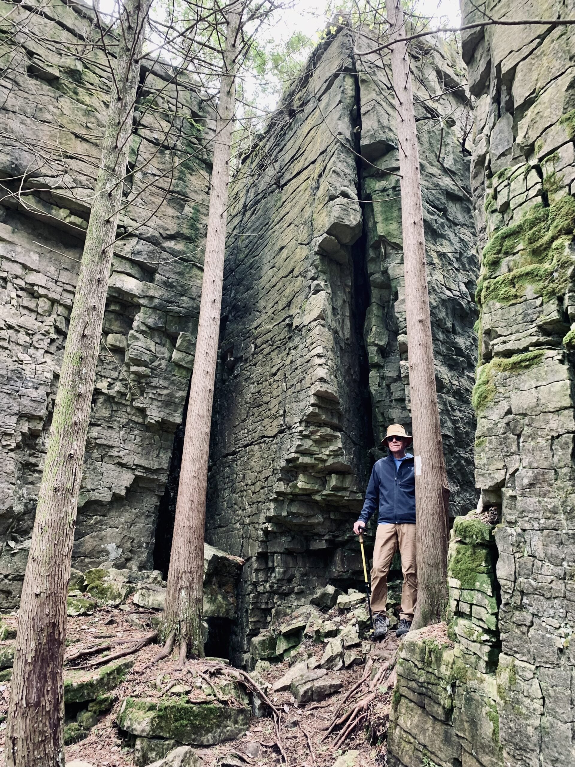
Boyd’s Crevices
https://hikes.brucetrail.org/event/boyds-crevices/Sorry, the registration cut-off time for this hike has been reached.Not a member? Click here to join today!Hosting Club: Sydenham
Category: General Hike
Location (Google Maps): 11th Concession – north of 83.9 km where the road intersects the Owen Sound Rail Trail. BTC Map #32.Hike Leader(s): Ian Mills
Pace: Medium: 3 to 4 km/h
Terrain: Moderate: Some hills and/or poor footing, There might be muddy sections., There might be sections with water on the trail.
Distance: 5+ kmDescription
In and out hike to the giant dolostone blocks where we will have a quick break for snacks. Proper hiking footwear required and a walking stick may be helpful. BTC Map #32. - 18June 18, 2026
NEW TIME 8:00 Long Hike, Glen Road Jordan
https://hikes.brucetrail.org/event/new-time-800-long-hike-glen-road-jordan-5/Sorry, the registration cut-off time for this hike has been reached.Not a member? Click here to join today!Hosting Club: Niagara
Location (Google Maps):
3640 Glen Road Jordan
Pace: Fast 5+ km/hr
Terrain: Strenuous: hilly, with steep climbs, poor footing
: 10 kmDescription
Hike in and around Ball’s Falls and Jordan. Dress for the weather: bring bug spray, sunscreen drink and poles.Hiking around Jordan
https://hikes.brucetrail.org/event/hiking-around-jordan-59/Sorry, the registration cut-off time for this hike has been reached.Not a member? Click here to join today!Hosting Club: Niagara
Location (Google Maps): Sho’arishon Park (Jordan Hollow)
Hike Leader(s): Bill Russell Click here to contact Hike Leader(s)
Pace: Medium 3- 4 km/hr
Terrain: Moderate: some hills and some poor footing
Distance: 7 kmDescription
Hiking in and around Jordan, Jim Rainforth Trail and Balls Falls (alternating every 3 weeks)Urban Walk: Valley View/Huntington Park
https://hikes.brucetrail.org/event/urban-walk-valley-view-huntington-park/Sorry, the registration cut-off time for this hike has been reached.Not a member? Click here to join today!Hosting Club: Toronto
Category: Urban Walk
Location (Google Maps): Parking lot is off Sycamore Drive, East of Bayview , across Starbucks plaza
Bus 91 from Finch East station stops at Sycamore station.Hike Leader(s): Mohammad Aghamiri
Pace: Moderate (3-4 km/hr)
Terrain: Hilly, Level 2 (Intermediate – some hills and uneven surfaces, rocks and roots underfoot)
Distance (km): 6-7 kmDescription
We will explore Valleyview and Maple View parks, and walk along German Mill Creak, in return we stop in Huntington park and have snack under beautiful shed.Although this is considered an “Urban Walk”, you can expect some hills up and down and uneven surfaces with tree roots. Please bring hiking poles, water and snacks.
CANCELLED - Halton Agreement Forest - using All Trails to navigate your hike
https://hikes.brucetrail.org/event/halton-agreement-forest-using-all-trails-to-navigate-your-hike-2/Sorry, the registration cut-off time for this hike has been reached.Not a member? Click here to join today!Hosting Club: Iroquoia
Category: General Hike
Location (Google Maps): Meet at the corner of 10 Side Road and 4th Line at 9:15 am.Hike Leader(s): Karen Bergmann Click here to contact Hike Leader(s)
Pace: Medium – 3 to 4 km/hr
Terrain: Moderate – Some hills and/or some poor footing
Distance: 8 kmsDescription
You’d like to explore new trails but aren’t sure of where you’re going? This hike will provide experience and tips on how to navigate hikes using the All Trails app. Be sure to download it and come prepared to participate in navigating the unmarked trails of the Halton Agreement Forest.
Cancelled - Toronto Islands Evening Walk
https://hikes.brucetrail.org/event/urban-walk-toronto-islands-evening-walk-25/Sorry, the registration cut-off time for this hike has been reached.Not a member? Click here to join today!Hosting Club: Toronto
Location (Google Maps):
Jack Layton Ferry Terminal, by the gate to the Wards Island Ferry. Please arrive 20 minutes prior to departure to check in with hike leader.
From Union Station take the LRT and get off at the stop Ferry Docks.Walk up to the Ferry Docks on Queens Quay West, street level. at the foot of Bay Street.
Hike Leader(s): Miriam Stevens Click here to contact Hike Leader(s)
Pace: Leisurely (2-3 km/hr)
Terrain: Flat, Level 1 (Easy – mostly on flat, well maintained trails with hard-packed surface)
Distance (km): 6-9 kmDescription
** Cancelled due to unsettled weather **This evening’s walk is cancelled due to the unsettled weather conditions.
After a day’s work come and “cool off” on the Toronto Islands free of fumes and traffic. Enjoy the view of the city skyline and Toronto’s beautiful island parkland.
Pack a dinner for a sit down picnic. Also bring a warm jacket and flashlight.
Return fare ticket for the ferry is $9.57 for adults, $6.15 for seniors
Please check the hike schedule for weather related cancellations (hike will be updated by 11:00 AM day of the hike if any changes)
Toronto Island evening hikes will take place every Thursday in May and June 2026.
Same time and same meeting place. No preregistration is required – just show up at the ferry docks at 5:40 PM and sign in with the hike leader.
WEEKNIGHT RAINBOW HIKE: Escarpment Rail Trail - Japanese Interval Walking
https://hikes.brucetrail.org/event/weeknight-rainbow-hike-escarpment-rail-trail-japanese-interval-walking/Sorry, the registration cut-off time for this hike has been reached.Not a member? Click here to join today!Hosting Club: Iroquoia
Category: Rainbow Hike
Location (Google Maps): Top of Wentworth Stairs at Mountain Brow West Park, HamiltonHike Leader(s): Doug O’Neill Click here to contact Hike Leader(s)
Pace: Brisk – 4 to 5 km/hr, Leisurely – 3km/hr or less
Terrain: Easy – Mostly flat and usually good footing, Strenuous – Hilly with steep climbs and some poor footing
Distance: 8 KM APPROXDescription
Everyone is welcome on this uber-friendly, all-inclusive 2SLGBTQAI+ Rainbow Hike.
Tonight’s hike, mostly along the Bruce Trail Rail Trail (close to downtown), includes an (optional) intro to Japanese interval walking (Nihon-shiki)—which we’ll try for at east one 30-minute segment. The rest of the evening you simply walk at your regular pace.Trail description: It’s 90% flat. The steep bit, you ask? Climbing Margate Stairs and descending Wentworth Stairs.
How it works:
• Alternate 3 minutes of brisk walking (enough to raise your heart rate and make talking difficult) with 3 minutes of slower, recovery walking
• One cycle = 6 minutes; we’ll repeat it five times for a total of 30 minutes
• If everyone agrees, we’ll try another 30-minute interval toward the end of our evening hike.
• No one gets left behind 🙂Meeting point & route:
•We’ll meet at the TOP of Wentworth Stairs (one block below Concession Street) at Mountain Park, along Mountain Brow. From there, we’ll:
• Walk down Wentworth Stairs
• Join the Bruce Trail Rail Trail at Charlton Avenue
• Follow the flat trail east to Margate Stairs
• Up the stairs to Mountain Brow, hike west along top of escarpment back to where we started.What to bring:
Bring water (750 ml) and energizing snacks—especially if you don’t eat beforehand. Insect repellent and sunblock also recommended. Sturdy shoes or runners are recommended.Parking details:
Some parking on Mountain Park Avenue near Juravinski Hospital in a few designated areas. Or try the Shoppers DrugMart Parking lot at Concession & Wentworth, or along Concession.Coming by transit: From downtown, take Route 23, 24 or 25 up the mountain and get off at Shoppers DrugMart at the corner of Concession and Wentworth. The meeting spot is a 4-minute walk from there.
Everyone gets a Bruce Trail Rainbow Badge! Again, this is NOT a high-intensive evening. The Japanese interval walking is 30-minutes of the hike.
“Click here to contact Hike Leader” on this form.
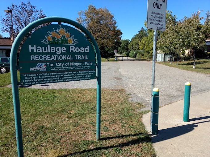
Haulage Trail with Fireman's Park
https://hikes.brucetrail.org/event/haulage-trail-with-firemans-park/Sorry, the registration cut-off time for this hike has been reached.Not a member? Click here to join today!Hosting Club: Niagara
Category: Urban
Location (Google Maps): Meet in the upper parking lot of Fireman’s Park, Dorchester and Mountain Rds, Niagara FallsHike Leader(s): Margaret Northfield Click here to contact Hike Leader(s)
Pace: Medium 3- 4 km/hr
Terrain: Easy: mostly flat, good footing
Distance: 5-6kmDescription
This urban walk with take us along the Haulage Trail, along St Paul and through Caliguiro Estates back to Fireman’s Park. - 19June 19, 2026
Dog-Friendly Hike: Hockley Valley
https://hikes.brucetrail.org/event/car-hike-dog-friendly-caledon-side-trail-hikes-2/Sorry, the registration cut-off time for this hike has been reached.Not a member? Click here to join today!Hosting Club: Toronto, Caledon Hills
Category: Car Hike
Location (Google Maps):Hockley Valley South
Hike Leader(s): Lindita Kalo Click here to contact Hike Leader(s)
Pace: Moderate (3-4 km/hr)
Terrain: Challenging, Level 2 (Intermediate – some hills and uneven surfaces, rocks and roots underfoot), Variable
Distance (km): 10kmDescription
Join me on the series of dog friendly to complete Caledon side trail challenge. Hockley Valley main Bruce trail and side trail.
Those hikes have some hills. We will keep moderate speed. For those joining both hikes be true to your abilities of hiking long distance.An email will be send to register hikers before the day.
9:00 am Niagara on the Lake Tour & Some Yoga + Summer Solstice Garden Party!
https://hikes.brucetrail.org/event/900-am-niagara-on-the-lake-tour-some-yoga-24/Sorry, the registration cut-off time for this hike has been reached.Not a member? Click here to join today!Hike open to BTC Members only.
Hosting Club: Niagara
Category: Urban
Location (Google Maps):Veteran’s Memorial Park, park just outside the park on King St.
Hike Leader(s): Robin Garrett Click here to contact Hike Leader(s)
Pace: Leisurely <3 km/hr
Distance: 5 km
Description
Enjoy the benefits of pausing for a yoga practice as we tour through the trails, parkland and Historic Niagara-on-the-Lake. No mat required. Movement will focus on a flow of standing poses designed especially for hikers. Following our hike, you are invited to Robin’s garden for a summer solstice celebration (location will be emailed to registrants the day before). Please bring a mug and a chair, and you are welcome to bring finger food. This will be a zero-waste gathering!Niagara E2E #4: Short Hills to Welland Canal
https://hikes.brucetrail.org/event/niagara-e2e-4-short-hills-to-welland-canal/Sorry, the registration cut-off time for this hike has been reached.Not a member? Click here to join today!Hike open to BTC Members only.
Hosting Club: Dufferin Hi-Land
Category: General Hike
Location (Google Maps): Parking lot located at the end of Wiley Road in Short Hills Provincial Park. See Google Map links for GPS.Hike Leader(s): Stuart Law Click here to contact Hike Leader(s)
Pace: Medium
Terrain: Moderate, Slippery and Steep Sections
Distance: 18.5 kmsDescription
Join us on this shuttle hike in a series of Friday hikes across the beautiful Niagara Section. Mud, rocks and slippery slopes guaranteed. Please bring a garbage bag and an extra pair of footwear for the drive back. Boots mandatory. Hiking poles recommended. Please wear a hat, long sleeves and long pants and bring a head net for the bugs (just in case), 2.5L of water, a snack, a lunch, bug spray and sunscreen.
Afternoon Hike - Rattlesnake Conservation Area
https://hikes.brucetrail.org/event/afternoon-hike-rattlesnake-conservation-area/Sorry, the registration cut-off time for this hike has been reached.Not a member? Click here to join today!Hosting Club: Iroquoia
Category: Afternoon/Evening Hikes
Location (Google Maps): Meet at 4:15 at Rattlesnake Conservation Area in the first (upper) parking lot (reserve your time at conservationhalton.ca).Hike Leader(s): Karen Bergmann Click here to contact Hike Leader(s)
Pace: Medium – 3 to 4 km/hr
Terrain: Easy – Mostly flat and usually good footing
Distance: 6 kmsDescription
Meet at 4:15 at Rattlesnake Conservation Area in the first (upper) parking lot (reserve your time at conservationhalton.ca). We will hike along the side trails for about 6 kms. This is a fairly easy hike. - 20June 20, 2026
Kimberly Forest S.T. / Bill's Creek
https://hikes.brucetrail.org/event/kimberly-forest-s-t-bills-creek/Sorry, the registration cut-off time for this hike has been reached.Not a member? Click here to join today!Hosting Club: Beaver Valley
Location (Google Maps): Meet on the deck of the Beaver Valley Ski Club clubhouse. The address is 100 Pioneer Drive, Markdale. Enter the ski club property at the gates on Grey Road 30. Coordinates 44.357747 -80.544822
Hike Leader(s): Marg Parkin Click here to contact the hike leader.
Pace: Leisurely
Terrain: Moderate
Length of Hike: Short hike of 45 minutes, longer option is 1 hr 20 minDescription
Our hike offers two distances: a short 45-minute hike (2.5km) into the forest, and a longer 1.5 hour (5km) hike, going farther along the trail which will include the always-interesting karst Bill’s Creek. Have you ever wondered what goes on behind the scenes of trail-making for our hiking pleasure? Come out to the Beaver Valley club’s post-AGM hike, and learn about trail-making partnerships, coordination and construction as you stroll the trail from the Beaver Valley ski club into the Kimberly Forest. We will be accompanied by Cathy Little, who has facilitated the sharing of trails for hiking, skiing, biking and snowshoeing. Cathy will share some interesting stories from her 10+ years of partnership-building and will encourage discussion.Awenda Provincial Park and Sainte-Marie among the Hurons/Wye Marsh
https://hikes.brucetrail.org/event/awenda-provincial-park-and-sainte-marie-among-the-hurons-wye-marsh/Sorry, the registration cut-off time for this hike has been reached.Not a member? Click here to join today!Trip Information
Departure Time: 08:00
Return to City Time: 18:30
Departure Point: York Mills Bus PickupOptional Items
Hosting Club: Toronto
Category: Bus Hike
Location (Google Maps): Awenda Provincial ParkHike Leader(s): Robin Crombie and Ted Moriarty Click here to contact Hike Leader(s)
Pace: Moderate (3-4 km/hr)
Terrain: Level 2 (Intermediate – some hills and uneven surfaces, rocks and roots underfoot)
Distance (km): About 10 kmDescription
Join us on this trip to beautiful Awenda Provincial Park, on the shores of Georgian Bay, where we’ll enjoy a lovely circular route, the Bluff Trail, and take a detour down the staircase to the beach for lunch. Afterwards, we’ll make the short drive to Highway 12, where you’ll have the opportunity to visit one of two local gems:- Saint-Marie among the Hurons, an historic site and Huronia education centre
OR
- Wye Marsh Wildlife Centre,
Please note that while there will not be time for a refreshment stop, Sainte-Marie has an onsite restaurant and patio.
From June 19 to 30, Saint-Marie is also offering free online Indigenous-led learning resources here.
Car Hike: Exploring Uxbridge Trails (Wilder Forest, Walker Woods, and Glen Major Forest)
https://hikes.brucetrail.org/event/car-hike-exploring-uxbridge-trails-wilder-forest-walker-woods-and-glen-major-forest-20/Sorry, the registration cut-off time for this hike has been reached.Not a member? Click here to join today!Hosting Club: Toronto
Category: Car Hike
Location (Google Maps):2499 Brock Rd, Uxbridge, ON L9P 1R4. We will meet at the East Duffins Headwaters parking lot at the WILDER FOREST trail head. As soon as you got off the Brock Road, passing the horse back riding facility, there is a free designated parking lot 70 meters down the lane to your right. It includes a sign board for East Duffins Headwaters with a map of the trails. Please do not park on the lane or in the horse back riding property.
Hike Leader(s): Amir Alemohammad Click here to contact Hike Leader(s)
Pace: Moderate (3-4 km/hr)
Terrain: Flat, Hilly, Level 2 (Intermediate – some hills and uneven surfaces, rocks and roots underfoot)
Distance (km): Approx.15-16 KmDescription
Join us for a delightful hike in Uxbridge, as we explore Wilder Forest, Walker Woods, and Glen Major Forest on a scenic loop starting from Brock Road. We’ll pass Concession Road 6, heading east and back, while also venturing onto several side trails for even more stunning views.What to Expect:
•Beautiful scenic views and lookouts facing south
•A mix of hilly and flat terrain
•Frequent 2-minute breaks for hydration and photos, with a 10 minute snack stop
•Stay on designated trails at all time
What to Bring and Wear:
•Hiking Boots and poles (recommended) and be prepared for the ticks on the trail, keep your bug spray handy.
•At least 2 liters of water
•Your favorite snacks (pack your own refreshments for an outdoor meal)
•Dress according to variable weather conditions!
Important Details:
•Stay on the designated trails
•Be prepared for the elements and enjoy the adventure!
Looking forward to seeing you on the trail!
Don’t forget your camera and a smile as we explore the beauty of the Uxbridge trails!
This is a joint hike with the Oak Ridges Trail Association (ORTA).
Six Pack at Blue - Lavender to Nottawasaga 9/10 Sideroad
https://hikes.brucetrail.org/event/six-pack-at-blue-lavender-to-nottawasaga-9-10-sideroad/Sorry, the registration cut-off time for this hike has been reached.Not a member? Click here to join today!Hosting Club: Blue Mountains
Category: Organized Hike
Location (Google Maps): Tim Hortons, First street, Collingwood, or 8667 Nottawasaga Sideroad 9, Glen HuronHike Leader(s): Murray Morrison Click here to contact Hike Leader(s)
Pace: Medium – 3 to 4 km/hr
Terrain: Moderate – Some hills and/or some poor footing
Distance: 14.7 kilometersDescription
We will be hiking the Bruce Trail from Lavender Cemetery to Nottawasaga 9/10 Sideroad. At the moderate pace of 3 to 4 Km per hour the 14.7-kilometer hike should take about 5 hours with nutrition breaks. There are two strenuous climbs out of valleys, varied terrain, rolling escarpment views and peaceful meadows on this hike. Please bring lunch or snacks for a nutritional break. Bug protection is advised.
We will need to car jockey from 9/10 Sideroad to Lavender. We can carpool from Tim Horton’s at 8:00 a.m. or meet at Concession 9/10 Sideroad at 8:30 a.m.
Dates for six-pack hikes are as follows;
20 June 2026
27 June 2026
12 Sept 2026
19 Sept 2026
26 Sept 2026
17 Oct 2026Boyd Conservation Park Vaughan
https://hikes.brucetrail.org/event/car-hike-boyd-conservation-park-vaughan-14/Sorry, the registration cut-off time for this hike has been reached.Not a member? Click here to join today!Hosting Club: Toronto
Location (Google Maps): Free Parking lot before entrance of park on Islington Ave.
Hike Leader(s): Mohammad Aghamiri Click here to contact Hike Leader(s)
Pace: Moderate (3-4 km/hr)
Terrain: Hilly, Level 2 (Intermediate – some hills and uneven surfaces, rocks and roots underfoot), Variable
Distance (km): 12-14 kmDescription
Let’s hike Boyd conservation park trails through beautiful valleys.Please bring lots of water and snacks ,hiking poles are recommended
phone number for the day of hike 289 588 6482
8:30 a.m. Dog Pack Walk
https://hikes.brucetrail.org/event/830-a-m-dog-pack-walk/Sorry, the registration cut-off time for this hike has been reached.Not a member? Click here to join today!Hosting Club: Niagara
Category: Dog Pack Walk
Location (Google Maps): Woodend Conservation Area- Park at Taylor Road entranceHike Leader(s): Sam Rutherford Click here to contact Hike Leader(s)
Pace: Leisurely <3 km/hr
Terrain: Moderate: some hills and some poor footing
Distance: 4 kmsDescription
This dog pack walk is a structured group walk where dogs and their handlers walk together on-lead in a natural environment. It promotes exercise, calm socialization and exposure to other dogs and people in a safe, controlled setting. We will meet at the Taylor Road parking area and follow the Wetland Ridge Side Trail out to the main trail and follow the main trail back to the parking area. Dogs must be kept on-lead and under control at all times. Please bring water and treats for you and your dog.Seven Rivers Hike Badge Series - Hike 4
https://hikes.brucetrail.org/event/seven-rivers-hike-badge-series-hike-4/Sorry, the registration cut-off time for this hike has been reached.Not a member? Click here to join today!Hosting Club: Dufferin Hi-Land
Category: General Hike
Location (Google Maps): Pine River Dufferin Hi Land Section Map 20
Parking: new BT parking lot on 15th side Rd just west of Prince of Wales Rd.Hike Leader(s): Tristan Goguen and Pat Foley Click here to contact Hike Leader(s)
Pace: Medium
Terrain: Moderate
Distance: Short Hike 8.63 Longer hike 12.45Description
Today we will hike south bound on the main trail from the parking are to where the main trail intersects with the Pine River Valley Side Trail. We will hike the Pine River Valley side trail to the second intersection with the Carl Alexander Side Trail. Take the Carl Alexander Side Trail back to the Pine River Valley Side trail then proceed back to the main trail. From there we will hike south bound to the Bell Look out side Trail, enjoy the view then return to the main trail to continue hiking south bound past the Pine River Fishing area and then along the river . We will the cross River Road and pick up the Kilgore side Trail on the north side and return to the main trail and the parking lot. Total distance to this point is approximately 8.63 Km. For enthusiasts we can continue north bound on Prince of Wales Rd from the parking are to the intersection with the Melodonna Side Trail. From there we will follow the side trail back to the main trail and return to the cars. With the added distance the total would be 12.45 km.Please be prepared for the weather, we will hike rain or shine. Ensure you have enough water,lunch and snacks, sunscreen and bug repellent. Hats and sunglasses are recommended as are poles and sturdy shoes.
For those wishing to earn their 7 Rivers – complete all 7 hikes, badges will be available on the last day from the hike leaders at a cost of $10 for members and $15 for non members.
Anyone completing make-up hikes may log their hikes and apply directly to the Dufferin Highlands BT Club for the badge.
🇨🇦 HISTORIC HIKE - LYNN VALLEY TRAIL - SIMCOE TO PORT DOVER - 15 KM OR 24 KM
https://hikes.brucetrail.org/event/%f0%9f%87%a8%f0%9f%87%a6-historic-hike-lynn-valley-trail-simcoe-to-port-dover-15-km-or-24-km/Sorry, the registration cut-off time for this hike has been reached.Not a member? Click here to join today!Hosting Club: Toronto
Category: Car Hike
Location (Google Maps): Coordinates: 42.829197, -80.298343
Parking and departure: Meet for a 9:30 am departure from Simcoe Memorial Park parking lot, 273 Owen St. Simcoe, ON, N3Y 2V3 Norfolk County. (Simcoe ON Hwy 24 south)
If you want the shorter hike of 15 km arrive at 8:50 am to do a car shuttle to drop off your car and return to the start.Hike Leader(s): Jeanette Vincent Click here to contact Hike Leader(s)
Pace: Moderate (3-4 km/hr)
Terrain: Flat, Level 1 (Easy – mostly on flat, well maintained trails with hard-packed surface), Level 2 (Intermediate – some hills and uneven surfaces, rocks and roots underfoot)
Distance (km): 15km or 24kmDescription
🇨🇦 HISTORIC HIKE – LYNN VALLEY TRAIL – SIMCOE TO PORT DOVER – 15 KM OR 24 KMAbout the historic hike: The rail trail in Carolinian Canada is one of Canada’s best, following the Lynn River to Lake Erie, We will hike the trail to Dover approximately 3 1/2 – 4 km per hour, flat easy terrain. The Historic talk by Bob Rennie will begin at noon once we are at the parking lot on Prospect St. in Dover and we will hike for an hour throughout the town approximately 3 km hearing Dover’s history. Lunch stop will be approximately at 1pm, you can purchase your “fish” lunch at a local restaurant or bring your lunch and sit on benches at the lighthouse pier and enjoy the view. After lunch those of us hiking back to Simcoe will continue on with the hike and those with their cars on Prospect St. can enjoy the ambience of Dover a little longer.
Originally part of the Grand Trunk Railway line, the rail line was still very much operational when Bob lived there (until his 20s). It became the former CNR rail line which was established along the pioneer river trail in 1873 as the Lake Huron and Port Dover Railway. The rail line was abandoned in 1988.
Bob, guest of this hike, will share Dover’s early “discovery” by French priests in 1669 previously inhabited by Algonquins and Neutrals. – Dover’s founding by his ancestor and early development of Dover Mills. – War of 1812 Brock’s attack on Detroit out of Dover, and the burning/redevelopment as Port Dover. – Rum running days in the prohibition era. – The importance of the largest fresh water fishing fleet in the world.
Car Hike: Scotsdale Farm
https://hikes.brucetrail.org/event/car-hike-scotsdale-farm-21/Sorry, the registration cut-off time for this hike has been reached.Not a member? Click here to join today!Hosting Club: Caledon Hills
Category: General
Location (Google Maps): Scotsdale Farm, Map 13. Directions; from Highway 401, head north on Trafalgar Road past Georgetown. Trafalgar briefly merges with Highway 7 for about 3 km before separating to the right at the village of Silver Creek. At the stop light in Silver Creek, continue north on Trafalgar Road for about 1 km to the entrance of Scotsdale Farm on your right. Drive in about half a kilometre to reach the parking area.Hike Leader(s): Lana Hubbard Click here to contact Hike Leader(s)
Pace: Medium – 3 to 4 km/hour
Terrain: Moderate – some hills and/or some poor footing
Distance: 14 kmDescription
🌈 Join us for a queer/trans-led, 2SLGBTQIA+ inclusive loop hike along the main Bruce Trail and its scenic side trails, including the stunning Great Esker Side Trail.This hike is welcoming to LGBTQ+ hikers, and anyone interested in connecting with community while enjoying a beautiful day on the trail.
We’ll be hiking approximately 14 km at a medium pace. Please dress appropriately for the weather, bring plenty of water, and pack snacks or a light lunch. Some sections of the trail are rocky, so hiking poles are highly recommended.
Weather permitting, I’ll be heading to the Copper Kettle after the hike for refreshments, and everyone is welcome to join. ^_^
Geology Hike #8 (Indian Falls) & #11 (Lindenwood)
https://hikes.brucetrail.org/event/geology-hike-8-indian-falls-11-lindenwood-2/Sorry, the registration cut-off time for this hike has been reached.Not a member? Click here to join today!Hosting Club: Sydenham
Category: Geology Hike
Location (Google Maps):Indian Falls Conservation Area parking lot accessed from Grey Road 1.
Hike Leader(s): Jeannine Kralt Click here to contact Hike Leader(s)
Pace: Leisurely: 3 km/h or less
Terrain: Easy: Mostly flat and good footing., Moderate: Some hills and/or poor footing, Strenuous: Hilly with steep climbs and some poor footing., There might be muddy sections., There might be sections with water on the trail.
Distance: 4.2 km combinedDescription
This is a combination of 2 hikes as described in “Walking Through Time” , Beth Gilhespy’s book that explores the geology of the Niagara Escarpment in the Sydenham Bruce Trail section. We will park and meet at the first hike (1.6 km loop): Indian Falls, accessed from the Grey Sauble Conservation Area parking lot. This trail features a magnificent example of the falls tumbling over layers of rock from the Manitoulin dolostone layer down to Queenston shale. (This is not on the Bruce Trail, but is part of the GSCA trails.) At times this trail is closed due to slippery conditions, so this part of our hike will be decided at the parking lot on the day of the hike.We will then carpool from this location a short distance north to our second hike of the day, # 11 Lindenwood Nature Reserve. The parking lot ( 44.685276 -80.995970 ) is located on Lindenwood Road between Grey Road 17 and Grey Road 1. This is a loop hike of 2.6 km featuring impressive erratic boulders, a prime example of an alvar and a newly constructed donor arch recognizing the generosity of our Bruce Trail supporters.
Bring water and a pack lunch to enjoy between the hikes . Beth’s Sydenham geology book and others will be available for purchase (cash, or etransfer). A Sydenham Bruce Trail Geology Badge has been developed. Details can be shared from hike leader during hike.
Car Hike: Hockley Valley, Map 18
https://hikes.brucetrail.org/event/car-hike-hockley-valley-map-18-5/Sorry, the registration cut-off time for this hike has been reached.Not a member? Click here to join today!Hosting Club: Toronto, Caledon Hills
Category: Car Hike
Location (Google Maps):Hockley Valley Provincial Nature Reserve
Hike Leader(s): Al Brown Click here to contact Hike Leader(s)
Pace: Moderate (3-4 km/hr)
Terrain: Challenging, Hilly, Level 2 (Intermediate – some hills and uneven surfaces, rocks and roots underfoot)
Distance (km): 14 kmDescription
We will complete a loop hike through the nature preserve along one of the hilliest sections of the Trail.After the hike those interested can meet for refreshments in the local area.
To get to the meeting point drive north on Hwy 10 past Orangeville to Hockley Road. Turn right and go about 6 km to the parking area. It is across the road from the Black Birch restaurant.
Ferns on the Trail - Part of Iroquoia Bruce Trail Club’s Discovering Nature Series
https://hikes.brucetrail.org/event/ferns-on-the-trail-part-of-iroquoia-bruce-trail-clubs-discovering-nature-series/Sorry, the registration cut-off time for this hike has been reached.Not a member? Click here to join today!Hosting Club: Iroquoia
Category: Iroquoia BTC Naturalist Hike Series : Discovering Nature, One Hike at a Time.
Location (Google Maps): Meet at 10:15 am at the Pear Tree parking lot on 15 Side Road at Speyside.Hike Leader(s): Karen Bergmann Click here to contact Hike Leader(s)
Pace: Leisurely – 3km/hr or less
Terrain: Moderate – Some hills and/or some poor footing
Distance: 6 kmsDescription
Would you like to learn more about the Ferns you see along the trail? This is the hike for you! Rhiannon Carruthers, Bruce Trail Conservancy Volunteer Coordinator, is our BTC knowledge expert on Ferns (and other plants). On this hike, Rhiannon will identify various Ferns and tell us how to identify them and how they reproduce.
If you’d like to brush up on your ferns prior to the hike, you may wish to view The Fascinating World of Ferns BTC YouTube Webinar Rhiannon hosted. Here is a link: https://youtu.be/flKIyVdbyWQ?si=9c06TbNdo8glbxroWe will meet in the Pear Tree parking lot on 15 Side Road at Speyside and hike the main trail, Al Shaw Side Trail and into the St. Helena Forest, back to the cars. Although the hike is just under 6 kms, we will be stopping along the way, so the hike will take about 2 hours. Bring bug spray and bug net as this area can be buggy.
Stargazing and Evening Hike
https://hikes.brucetrail.org/event/stargazing-and-evening-hike/Sorry, the registration cut-off time for this hike has been reached.Not a member? Click here to join today!Hosting Club: Blue Mountains
Category: Organized Hike
Location (Google Maps): Hike meets in the parking lot behind Tim Hortons on First St. in Collingwood.Hike Leader(s): Robert Johnston Click here to contact Hike Leader(s)
Pace: Leisurely – 3 km/hr. or less
Terrain: Moderate – Some hills and/or some poor footing
Distance: 5KmDescription
RESCHEDULED FROM 28 MARCH 2026. Join us this spring for our first Blue Mountains Bruce Trail Club Stargazing hike event. This is a evening hike followed by viewing of night sky features at the E.C. Carr Astronomical Observatory. We will meet behind Tim Hortons on First Street in Collingwood and carpool to the Observatory off Blue Mountains 6th Sideroad in Loree. LEAVING TIM’S AT 7:45PM. Should get us to observatory by 8:15. There we will hike a loop around the Margaret Paull Sidetrail returning to the observatory approximately 9:30 for light refreshments and viewing of night sky objects. There will be a host astronomer on site from the Royal Astronomical Society of Canada to direct this activity. Note sunset is at 9:10 PM so our hike will be in low light conditions. There is a $25 fee ($30 for non-members) to cover the observatory rental cost and refreshments. This hike is weather dependent and in overcast or rainy conditions may be cancelled and rescheduled for a future date.