Categories
- 23May 23, 2026
Blue Mountains Annual End to End-TWO DAY EVENT.
https://hikes.brucetrail.org/event/blue-mountains-annual-end-to-end-two-day-event-3/Sorry, the registration cut-off time for this hike has been reached.Not a member? Click here to join today!This is a Multi-Day Hike
You are signing up for the following dates and times:
2026-05-23 at 06:30
2026-05-24 at 06:30Hosting Club: Blue Mountains
Category: End-to-End
Location (Google Maps):Meet/park at Highlands Nordic Duntroon Ontario
Hike Leader(s): Paul Swindall Click here to contact Hike Leader(s)
Pace: Brisk – 4 to 5 km/hr, Medium – 3 to 4 km/hr
Terrain: Moderate – Some hills and/or some poor footing
Distance: 69 km -Day 1: 37km Day 2: 32kmDescription
Join us this spring for the Blue Mountains Bruce Trail Club annual End-to-End hike event. This 2 Day Hike is for those hikers keen on a great big challenge You will wind your way through the beautiful and varied terrain of the Blue Mountains Club trails. Enjoy the early signs of nature awakening at this time of the year, the beautiful vistas and the rugged escarpment. You will cover the 69 km distance of our section which runs from Lavender to Swiss Meadows. Checkpoint stations will be offered approximately every 10 kms offering snacks, water refill and assistance along the way. A BBQ at Highlands Nordic is included at the end of Saturday Hike commencing at 1:00 pm. Hike details will be emailed to participants shortly after registration is received. Note, this event consists of longer distances and is generally not suitable for beginning hikers. REGISTRATION FOR NON-MEMBERS WILL OPEN 10 MARCH 2026Blue Mountains THREE DAY End to End - THREE DAY EVENT
https://hikes.brucetrail.org/event/blue-mountains-three-day-end-to-end-three-day-event-3/Sorry, the registration cut-off time for this hike has been reached.Not a member? Click here to join today!This is a Multi-Day Hike
You are signing up for the following dates and times:
2026-05-23 at 07:00
2026-05-24 at 07:00
2026-05-25 at 07:00Hosting Club: Blue Mountains
Category: End-to-End
Location (Google Maps):Day 1 Parking/Meeting location is at Nottawasaga Bluffs Conservation Area. Day 2 & 3 parking will be near Pretty River Valley Provincial Park. Details will follow after registration
Hike Leader(s): Robert Johnston Click here to contact Hike Leader(s)
Pace: Brisk – 4 to 5 km/hr
Terrain: Moderate – Some hills and/or some poor footing
Distance: 67 kmDescription
Join us this spring for the Blue Mountains Bruce Trail Club THREE DAY End-to-End hike event. This 3 Day hike is for those hikers wanting to complete our section over three days. Approximate Daily Hike Lengths: Day 1–22Km, Day 2–20Km, Day 3–25Km. You will wind your way through the beautiful and varied terrain of the Blue Mountains Club trails. Enjoy the early signs of nature awakening at this time of the year, the beautiful vistas and the rugged escarpment. You will cover the 67 km distance of our section which runs from Lavender to Swiss Meadows. Checkpoint stations will be offered approximately every 10 kms with snacks, water refill and assistance. A BBQ is included on the Saturday at the end of the hike day, at Highlands Nordic, and will commence at 1:00 pm. Details will be emailed to participants shortly after registration is received. Note, this event consists of longer distances and is generally not suitable for beginning hikers. REGISTRATION FOR NON-MEMBERS WILL OPEN 10 MARCH 2026Sydenham Bruce Trail E2E Run - Day 5 of 8 Only
https://hikes.brucetrail.org/event/sydenham-bruce-trail-e2e-run-day-5-of-8-only/Sorry, the registration cut-off time for this hike has been reached.Not a member? Click here to join today!Hike open to BTC Members only.
Hosting Club: Sydenham, Peninsula
Category: Sydenham E2E Trail Run
Location (Google Maps): Day 5 of the E2E Trail Run of the Sydenham Bruce Trail section. Meeting at Irish Block Road BTC parking.Hike Leader(s): Margie Gloade; Natalie Mechalko Click here to contact Hike Leader(s)
Pace: Fast (5.5 – 7.0 km/h+): A quick pace maintained by experienced hikers or trail runners.
Terrain: Difficult: Steep ascents/descents, rocky scrambling, and some rugged escarpment paths.
Distance: About 19kmDescription
This is a single-day registration – Day 5 of 8.The Sydenham Bruce Trail Club (SBTC), in partnership with the Peninsula Bruce Trail Club (PBTC), is excited to offer its first-ever trail running Sydenham End-to-End series in 2026. Join the fun for one of the eight days in this trail running series! The trail running Sydenham E2E series will take place over 4 weekends and 8 days, starting at 7:30am. Below is the start and end location and estimated distance for this day (subject to change slightly). The group will meet at the end location, and carpool to the start of each day’s route. You are expected to participate in shuttling vehicles.
Please carefully read the details below to understand the logistics, costs, important notes, and fitness required for this challenge.
Saturday, May 23, 2026: Centennial Tower Parking Lot to Irish Block Rd BTC Parking; ~19km.
- When you register here, you are registering for only one day in the series. (You also have the option of registering for the whole series for $60 even if you aren’t able to make all eight days).
- These are group trail runs. It is not a race. It is not a hike. There may be a couple different pace groups that naturally form, but you will be expected to stay with a group and wait to regroup at key locations. Runners are expected to remain between the lead runner and the sweep at all times. Anticipate each day to be running for about 3+/- hours, at a pace ranging from 7-9 min./km.
- Participants are expected to have some experience trail running as this is difficult terrain. There are also some roads, and some active farm fields. In some locations throughout Sydenham, trail running will not be permitted near livestock. On roads, runners are expected to follow standard Highway Traffic Act regulations, crossing safely and running on the shoulder, in single file, facing oncoming traffic.
- Mandatory gear includes a whistle and minimum 250ml of water carrying capacity. Trail runners will need to carry their own water and fuel.
- At approximate mid-way points each day, there will be volunteer support arranged so you can fill up water bottles. Some snacks (e.g. oranges, bananas, pretzels, cookies, water) will be provided but please plan to be self-sufficient.
- Exercise care and caution and common sense on trails, especially when passing other trail users. Let others know you are coming and that you intend to pass. Headphones/earbuds are not permitted while participating in this group run.
- Participants must be age 16 years or older.
- Dogs are not permitted.
- This trail run is for BTC members only. To become a member, click here: https://brucetrail.org/.
- The designated meeting points will not incur any personal parking fees but parking space is limited. Participants are encouraged to car pool whenever possible.
The single day fee is $20. This fee covers snacks, vehicle shuttle, volunteer support, and a donation to the PBTC hike program. There is also an option to register for the whole series ($60).
As per BTC policy, no refunds will be considered 30 days before the series starts (not after April 1, 2026).
The trail run will go ahead rain or shine, however, in extremely inclement weather, a date may be cancelled and rescheduled, ideally prior to the May 31st finish date.
Falling Waters in Two (badge hike)
https://hikes.brucetrail.org/event/falling-waters-in-two-badge-hike/Sorry, the registration cut-off time for this hike has been reached.Not a member? Click here to join today!This is a Multi-Day Hike
You are signing up for the following dates and times:
2026-05-23 at 08:00
2026-05-24 at 08:00Hosting Club: Beaver Valley
Location (Google Maps): We will meet at the Beaver Valley Ski Club lower parking lot, arrive by 7:45 a.m. for an 8:00 a.m. hike start. The ski club address is 100 Pioneer Drive, Markdale (off Grey Road 30). Coordinates are 44.357382, -80.543331 . Follow the driveway past the front entrance, and park at the far end of the parking lot, past the tennis courts. From this parking lot we will use our hikers’ cars to shuttle to the Hogg’s Falls Parking lot to begin our hike.
Hike Leader(s): Marg Parkin Click here to contact the hike leader.
Terrain: Some rocky footing, Some steep sections, Strenuous
Length of Hike: 16 KM + 14 KM (2 hikes)Description
We expect carpets of Trillium, Trout Lily and other spring ephemerals on the forest floors of Beaver Valley for this 2-day spring hike. The Falling Waters hike is known for its waterfalls and streams. This is a challenging hike with lots of elevation up and down the valley slopes, passing Hogg’s Fall and Eugenia Falls. We will break the loop into two days’ hikes, doing approximately 16 km on Saturday, and 14 on Sunday. Participants should self evaluate their ability t0 maintain a pace of 4km/hr on this hike. We expect to hike about 5-6 hours per day, including a short lunch break. A badge awaits you after completing both hikes, as well as bragging rights to having completed approximately 1,500 metres of elevation over the total 30-kilometer hike. Hikers should carry ample water, snacks and lunch. Hiking poles are recommended. May’s weather is variable, so hikers should dress accordingly and bring sunscreen and insect repellent.Car Hike: Hockley Crest, Airport Rd to Hockley Rd
https://hikes.brucetrail.org/event/car-hike-hockley-crest-airport-rd-to-hockley-rd/Sorry, the registration cut-off time for this hike has been reached.Not a member? Click here to join today!Hosting Club: Toronto, Caledon Hills
Category: Cancelled
Location (Google Maps): Meet at the Bruce Trail Parking Lot on Mono 5 Sideroad on the north side of the 5th Sideroad.Hike Leader(s): Amir Alemohammad Click here to contact Hike Leader(s)
Pace: Moderate (3-4 km/hr)
Terrain: Flat, Hilly, Level 2 (Intermediate – some hills and uneven surfaces, rocks and roots underfoot), Variable
Distance (km): 12-14 kmDescription
Join us for a out and back hike in Hockley Crest. The route explores a diverse landscape of dense sugar maple and beech hardwood forests, open grassy meadows, active pine plantations, and steep ravines. We will explore the main and side trails of the Bruce Trail. Bring at least two liters of water and your favorite snacks. Boots mandatory, poles recommended. Be prepared for the ticks and bugs. This is a joint hike with the ORTA.
Sunday Side Trails / Sydney Bay Bluff and Hart's Tongue Ferns
https://hikes.brucetrail.org/event/sydney-bay-bluff-and-harts-tongue-ferns/Sorry, the registration cut-off time for this hike has been reached.Not a member? Click here to join today!Hosting Club: Peninsula
Category: Peninsula Blue Series
Location (Google Maps): Cape Croker Park, Park Road ParkingHike Leader(s): Jamie McDermid Click here to contact Hike Leader(s)
Pace: Medium (3.0 – 4.5 km/h): A comfortable pace for most hikers with steady progress.
Terrain: Moderate: Rolling hills, mild slopes and rocky paths.
Distance: 8 kmDescription
Peninsula BTC is offering a series of hikes covering all of the side trails on the Peninsula section of the Bruce Trail. These hikes are a great opportunity for those who want to do some hiking but don’t want to commit to a full end-to-end; for those who have completed an end-to-end and want to explore more of the beautiful trails on the Peninsula and for locals and visitors who want to get out on the trail on the weekend.The series will include 27 hikes on Sundays (and maybe the odd Saturday) over 2026 and 2027, covering more than 150 km of side trails or 78 trails! We will be offering hikes on a roughly biweekly basis, with hikes posted approximately two months in advance. The hikes will generally be loop hikes, although car shuttling may be required for a few hikes. Register for each hike individually, no need to commit to all 27 hikes!
For those who would like to earn the Peninsula Side Trails badge, these hikes provide a chance to join a group for some or all of the side trail hikes.
This hike uses the Hart’s Tongue Side Trail to make an 8km loop around Sydney Bay Bluff. The hike features views of Sydney Bay, some interesting rock features and lots of ferns and other plants in the lush, late spring forest.
Hikers should be prepared for cool weather and possible wet trails. Bring a lunch, water and snacks. Hike leader will contact registered hikers one week before the hike.
If you would like to be notified when the side trail hikes are posted, go to the bottom of the Hikes page on the PBTC website to sign-up for hike notifications.
School Bus Hike: Iroquoia E2E #8/8 Crawford Lake/Kelso
https://hikes.brucetrail.org/event/school-bus-hike-iroquoia-8-8/Sorry, the registration cut-off time for this hike has been reached.Not a member? Click here to join today!Trip Information
Departure Time: 08:30
Return to City Time: 18:30
Departure Point: Kipling Departure PointOptional Items
Hiking ($.01)Hosting Club: Toronto
Category: Bus Hike
Location (Google Maps): Crawford Lake/KelsoHike Leader(s): Tom Swales, Felix Wan Click here to contact Hike Leader(s)
Pace: Moderate (3-4 km/hr)
Terrain: Hilly, Level 2 (Intermediate – some hills and uneven surfaces, rocks and roots underfoot), Variable
Distance (km): 14 km/17 kmDescription
The final stage of our Iroquoia E2E will take us through Crawford Lake and Kelso Conservation Areas to the border between the Iroquoia and Toronto sections. For those not doing the E2E and prefer a shorter distance there will be an option to reduce the total distance by 3 km. Expect a later return (approx. 6:30 PM). We will have a stop in Milton before returning to Kipling for refreshments, socializing, and celebrating the accomplishment of finishing the Iroquoia section over the eight hikes this Spring and last Fall. Anyone is welcome regardless of doing the E2E.Trillium hike Richmond hill 240
https://hikes.brucetrail.org/event/car-hike-bethesda-trail-richmond-hill-37/Sorry, the registration cut-off time for this hike has been reached.Not a member? Click here to join today!Hosting Club: Toronto
Location (Google Maps): Oak Ridges Corridor, Bethesda Trail Head Parking Lot, Bethesda Side Road, Richmond Hill, Ontario
Hike Leader(s): Mohammad Aghamiri Click here to contact Hike Leader(s)
Pace: Moderate (3-4 km/hr)
Terrain: Hilly, Level 2 (Intermediate – some hills and uneven surfaces, rocks and roots underfoot), Variable
Distance (km): 14-15 kmDescription
Join us to explore the trails of York Regional Forest and the Oak Ridges Corridor at Jefferson Forest and Bond lake,From parking lot we hike thought Jefferson forest and continue to Bond Lake and have snack beside the lake and return to parking around 13 to 13.30
Please bring lots of water and snacks ,hiking poles are recommended
phone number for the day of hike 289 588 6482
CANCELLED 9:00 am Walker Creek 5 4 3 2 1 Grounding Hike
https://hikes.brucetrail.org/event/900-am-walker-creek-54321-grounding-hike/Sorry, the registration cut-off time for this hike has been reached.Not a member? Click here to join today!Hike open to BTC Members only.
Hosting Club: Niagara
Category: Cancelled
Location (Google Maps): Welland Canal parking area at Lock 1 on Lakeshore RoadHike Leader(s): Suzanne Gourluck Click here to contact Hike Leader(s)
Pace: Leisurely <3 km/hr
Terrain: Easy: mostly flat, good footing
Distance: 9 kmDescription
*This hike is one of our new MINDFULNESS seriesJoin me on this 5 4 3 2 1 grounding hike and learn a simple strategy for managing anxious racing thoughts. We will hike through Malcomson Eco Park along Sunshine beach, up Walker Creek and back, stopping a couple of times along the way to ground ourselves using the 5 4 3 2 1 technique.
*If the parking lot at the canal is full please park in Malcolmson Eco Park (accessed at the Niagara/Lakeshore intersection) and walk up to the canal.🇨🇦 HISTORIC HIKE - LAURA SECORD LEGACY TRAIL PART 1 - QUEENSTON TO NIAGARA COLLEGE - 15 KM
https://hikes.brucetrail.org/event/%f0%9f%87%a8%f0%9f%87%a6-historic-hike-laura-secord-legacy-trail-part-1-queenston-to-niagara-college-15-km/Sorry, the registration cut-off time for this hike has been reached.Not a member? Click here to join today!Hosting Club: Toronto
Category: Car Hike
Location (Google Maps): Parking and departure: Meet at 9:30 am, parking at Niagara College – Daniel J. Patterson Campus, 135 Taylor road, Niagara-on-the-Lake, L0S 1J0. Parking is paid, day parking fee is $6.35. Parking Lot 1A coordinates 43.152026, -79.166394. We will car shuttle from there to the start of the hike.Hike Leader(s): Jeanette Vincent Click here to contact Hike Leader(s)
Pace: Moderate (3-4 km/hr)
Terrain: Flat, Level 2 (Intermediate – some hills and uneven surfaces, rocks and roots underfoot)
Distance (km): 15kmDescription
About the historic hike (part 1): This hike is part 1 of the series of 2 hikes. We will hike Laura Secord Legacy Trail, a modern day approximation of Laura’s actual route from her homestead in Queenston to DeCew House in Thorold where she delivered her fateful message to Lt. Fitzgibbon on June 22, 1813. Divided into five distinct stages and starts at the historic Laura Secord Homestead in picturesque Queenston, and travels along secluded Dee Road, across the Niagara Parkway, and through tranquil vineyards featuring wonderful views of the Escarpment and Brock’s Monument. Encompassing everything from ancient forested trails, open spaces of Firemen’s Park, Niagara Falls, to the edge of the Escarpment, a foot bridge, and the trail passes through the famed Screaming Tunnel, featured in Halloween ghost stories and at least one David Cronenberg horror film, to modern city sidewalks and urban parks.The 32km trail route was developed based on historical authenticity, safety, and natural ambiance.After the hike you may want to visit: Laura Secord Homestead: 29 Queenston St. Queenston, ON. Hours 10-5pm. Admission: Adult -13+ $10.50, Children 3-7 $7.00
“Laura Secord – Walk Into History” – background on Laura to outline Laura’s remarkable effort to warn a British officer about an impending attack by the invading American forces. – the impact that this one person had on the War of 1812. – the effort to commemorate Laura’s 32 km “walk” 200 years later (2013) and Bob Rennie’s involvement in the Secord Walk commemoration and unveiling of the related First Nations memorial near the DeCew house.
Bob will deliver the talk in a War of 1812 uniform similar to that of Lt James Ftitzgibbon (the officer Laura went to warn).
About the guest: Bob Rennie UE is an amateur historian and historical living history reenactor. Bob has given many presentations on various aspects of Canada’s early history and spends much of his time at War of 1812 enactments and commemorations. He is a quest speaker at the GVTA (Grand Valley Trails Association) AGM, Tuesday May, 12, 6:30 to 8:30 pm at the Forest Heights branch of the Kitchener Public Library. Bob will speak from 7:30 to 8:30pm.
CANCELLED Geology Hike # 5 Boyd Crevice linear hike (extended)
https://hikes.brucetrail.org/event/geology-hike-5-boyd-crevice-linear-hike-extended/Sorry, the registration cut-off time for this hike has been reached.Not a member? Click here to join today!Hosting Club: Sydenham
Category: Geology Hike
Location (Google Maps):Dead end of Concession Road 11 south of Superior Street, Owen Sound. Roadside parking. Please park on the east side of the road. NOTE: ROAD CONSTRUCTION at Superior Street and 9th Avenue East (Hwy 6 & 10) . No access from west end of Superior Street. If you are coming from the south on Hwy 6 & 10, turn east (right) at Story brook Park Road. At Concession 10 turn left (north). At Superior Street turn left.(west) then turn left (south) on Concession Rd 11 to the trailhead. If coming from the north on 9th Avenue East, turn east at 8th Street East. Continue past the hospital to 28th Ave E/Concession Rd 10. turn right (south). At Superior Street turn west (right). At Concession Rd 11 turn left (south) to dead end parking. See map photo attached below.
Hike Leader(s): Sheri Hatcher Click here to contact Hike Leader(s)
Pace: Leisurely: 3 km/h or less
Terrain: Easy: Mostly flat and good footing., Moderate: Some hills and/or poor footing, Strenuous: Hilly with steep climbs and some poor footing., There might be muddy sections., There might be sections with water on the trail.
Distance: 5.5 km approx.Description
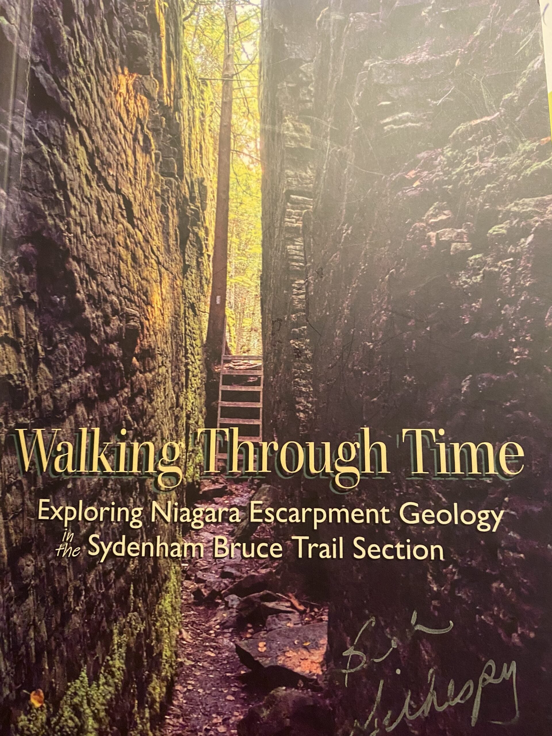
This is an extended version of Geology Hike # 5, following Beth Gilhespy’s book “Walking Through Time” in the Sydenham Bruce Trail Section. Please note the starting point for this hike. It is not the same as the trailhead in Beth’s Geology Book. This is a linear hike, starting on a rail trail and then entering the main trail and hiking east to the amazing karst geology, towering cliffs and cambering features of this iconic crevice system. We will return the same way.
Copies of Beth’s book will be available for purchase. Special member’s only price of $37.00 . Cash or etransfer. If paying with cash, please bring exact change. I am expecting a SPECIAL GUEST to join us ! Please bring water and a snack if you wish. Proper hiking footwear and hiking poles are recommended.
Rainbow Hike: Sho’aríshon Park to Ball's Falls
https://hikes.brucetrail.org/event/rainbow-hike-shoarishon-park-to-balls-falls/Sorry, the registration cut-off time for this hike has been reached.Not a member? Click here to join today!Hosting Club: Niagara
Category: Loop
Location (Google Maps): Sho’aríshon Park, 3039 King St, Jordan, ONHike Leader(s): Angela Lytle Click here to contact Hike Leader(s)
Pace: Leisurely <3 km/hr
Terrain: Strenuous: hilly, with steep climbs, poor footing
Distance: 4-5 kmDescription
Join the Niagara Bruce Trail Club, Bridges Niagara Immigrant and Refugee Services and PFLAG Niagara for a Rainbow Hike from Sho’aríshon Park to Ball’s Falls.What is a Rainbow Hike?
These hikes aim to bring 2S-LGBTQIA+ folks and newcomers together with other newcomers and community members, friends and allies to enjoy nature and connect to the land and enjoy nature in all seasons. It is an intentionally affirming space for people of diverse backgrounds and identities with a focus on 2S-LGBTQIA+ inclusion. Everyone is welcome. Pride badges and stickers are free for all hikers!
Hike Details
Route: This hike loops from the parking lot at Sho’aríshon Park (Neutral Nation Legacy Cultural Park) along the Bruce Trail into Ball’s Falls Conservation Area and back.
Read more about the park and Indigenous history of this area here: https://www.lincoln.ca/council-and-administration/news-updates/media-release-town-lincoln-celebrates-opening-shoarishon
Terrain: The path goes along the creek and then up a tall, steep set of stairs to get to the conservation area at the top of the escarpment. Once up top the path is fairly even, looping around the conservation area. We will visit the main waterfall and take a break – feel free to bring snacks to share! We will then descend the steps and steep pathway back down.
We will adjust the pace to the group but be prepared for some rocky or uneven footing and climbing up and down. The terrain is not suitable for folks with mobility challenges.
We strongly recommend using hiking poles. Wearing good hiking shoes is a must. Carry water and dress in layers for changeable weather and carry insect repellent.
The hike goes ahead rain or shine unless there are dangerous weather conditions – the hike leader will contact you if anything changes.
***Please arrive by 9:50 to check in with the hike leaders for departure at 10.
Google map link to the parking lot location: https://maps.app.goo.gl/2s9CMz32y5gqt2A86
Car Hike: Mono Cliffs CANCELLED
https://hikes.brucetrail.org/event/car-hike-mono-cliffs-8/Sorry, the registration cut-off time for this hike has been reached.Not a member? Click here to join today!Hosting Club: Toronto, Dufferin Hi-Land
Category: Car Hike
Location (Google Maps):Mono Cliffs Provincial Park, Map 19
Hike Leader(s): Al Brown Click here to contact Hike Leader(s)
Pace: Moderate (3-4 km/hr)
Terrain: Level 2 (Intermediate – some hills and uneven surfaces, rocks and roots underfoot), Variable
Distance (km): 14 kmDescription
We will complete a loop hike through Mono Cliffs PP and the North Outlier. The trail is mostly flat and under forest cover. We will stop at several viewpoints and natural features along the way.After the hike those interested may gather at a local establishment for refreshments.
To get to the meeting point go north on Hwy 10 past Orangeville to County Rd 8 (Mono Centre Road). Proceed east about 6 km to Mono Centre. The parking area for the community centre is 200 meters south of the T-intersection if you go too far. The entrance to the parking area is on your right just before a tennis court.
Urban Walk: Toronto Urban Badge Hike - 7 of 7
https://hikes.brucetrail.org/event/urban-walk-toronto-urban-badge-hike-7-of-7-3/Sorry, the registration cut-off time for this hike has been reached.Not a member? Click here to join today!Hosting Club: Toronto
Category: Urban Walk
Location (Google Maps): South Don River TrailHike Leader(s): Brian Rideout Click here to contact Hike Leader(s)
Pace: Moderate (3-4 km/hr)
Terrain: Flat
Distance (km): 9 kmDescription
Please join me at the south east corner of Overlea Blvd and Don Mills Rd by 10 AM. We will hike south on the Don Trail to the Distillery District (km 62.4 to km 71.4). Here is an online map with km markings of our route for all 7 hikes for the Toronto Urban Badge: https://onthegomap.com/s/c2c1hf3nPlease make sure you bring at least 2 liters of water, a lunch, bug spray and sunscreen.
Habitat Restoration Planting at Riverside Woods
https://hikes.brucetrail.org/event/habitat-restoration-planting-at-riverside-woods/Sorry, the registration cut-off time for this hike has been reached.Not a member? Click here to join today!Hosting Club: Caledon Hills
Category: Habitat Restoration Project
Location (Google Maps): Akela & Scouters Heather and Ross Hamlin Nature Reserve at Riverside WoodsHike Leader(s): Sandra Green Click here to contact Hike Leader(s)
Pace: Leisurely – 3 km/hour or less
Terrain: Easy – mostly flat and usually good footing
Distance: Less than 1 kmDescription
This is a family friendly event. Volunteers will help restore the habitat for the Red Headed Woodpecker! Come join the CHBTC Biodiversity Team as we add to the biodiversity of our Riverside Woods property. We will be installing a variety of trees and shrubs in an area that was previously infested with Japanese Knotweed.The event will begin at 10:30 a.m. out of the main parking lot at Riverside Woods. We will hike down to the planting location and discuss the work that has been undertaken by BTC Staff and CHBTC Volunteers to remove invasive species along the way. Participants are asked to wear pants and sturdy footwear. Please bring water for drinking, as well as gardening or work gloves. Shovels and extra gloves will be provided.
Blue Mountains Annual End to End-BBQ Only
https://hikes.brucetrail.org/event/blue-mountains-annual-end-to-end-bbq-only-2/Sorry, the registration cut-off time for this hike has been reached.Not a member? Click here to join today!Hosting Club: Blue Mountains
Category: Organized Hike
Location (Google Maps):Hike Leader(s): Robert Johnston Click here to contact Hike Leader(s)
Pace: Leisurely – 3 km/hr. or less
Terrain: Easy – Mostly flat and usually good footing
Distance: 0Description
We’re firing up the Grill with hot dogs and hamburgers! Blue Mountain Club Members and friends are invited to join in at the E2E BBQ. Come on out to socialize and welcome our hikers in after their first day.Please note if you are registered for either the 2 Day or 3 Day E2E your BBQ is included. No need to register and pay for this.
If you are a Volunteer for this event your BBQ cost FREE. No need to register and pay for this.
There is no badge for this event other than the coveted mustard and ketchup stain!
Registration will be open until Friday, May 22.
BBQ will be held Saturday 24 May 1 pm to 5 pm at Highlands Nordic