Categories
- 22May 22, 2026
Otter Lake and Maple Cross Nature Reserve at Cape Chin Birding Hike
https://hikes.brucetrail.org/event/otter-lake-and-maple-cross-nature-reserve-at-cape-chin-birding-hike/Sorry, the registration cut-off time for this hike has been reached.Not a member? Click here to join today!Hosting Club: Peninsula
Category: Birding
Location (Google Maps): 388 Cape Chin Road NorthHike Leader(s): Marg Glendon Click here to contact Hike Leader(s)
Pace: Leisurely (2.0 – 3.0 km/h): A relaxed pace with frequent breaks and a focus on enjoyment.
Terrain: Easy: Flat forested sections or lowland trails.
Distance: ~3.5 kmDescription
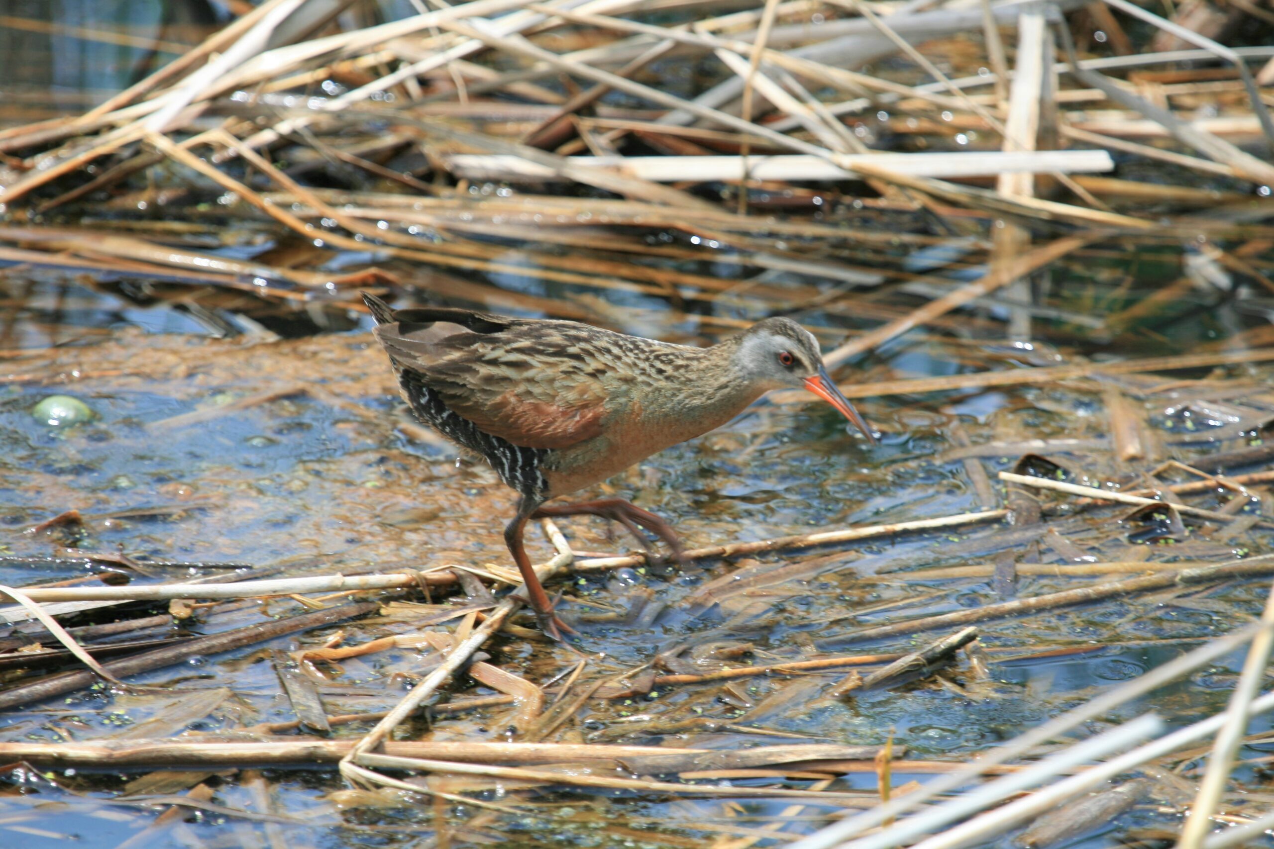
This is a “tandem” birding hike – Otter Lake Nature Reserve and nearby Maple Cross Nature Reserve at Cape Chin. Brian Popelier, BTC Ecologist, will introduce us to the wonders of Otter Lake’s Spring birding season, then at MCNRCC for more birding and to learn about habitat restoration here.The Otter Lake property is part of a larger provincially significant wetland complex. It is comprised of a variety of wetland habitats including meadow marsh, thicket swamp, deciduous treed swamp, Graminoid fen and the properties namesake, the shallow calcareous Otter Lake. The wetlands support water loving plants and host a variety of wetland and marsh birds, fish, amphibians and reptiles. introduce you to the wonders of Otter Lake’s spring birding season.
With 523 acres of iconic Saugeen (Bruce) Peninsula landscape, a breathtaking 270-degree view of Georgian Bay, and 1.8 kilometers of the Bruce Trail’s Optimum Route, the Maple Cross Nature Reserve at Cape Chin is a natural masterpiece and a true conservation gem.
Consider extending your day to enjoy more birding and hiking along the Bruce Trail.
In total, this hike will take about 2 1/2 – 3 hours. Bring binoculars, insect repellent, lunch, water and snacks. Wear sunscreen, hat, and sun protective clothing. We may encounter some wet spots, so wear water proof hiking boots and gators.
This is a perfect opportunity to work on your PBTC Birding Badge: https://peninsula.brucetrail.org/badges/
9:00 am Niagara-on-the-Lake Tour
https://hikes.brucetrail.org/event/900-am-niagara-on-the-lake-tour-62/Sorry, the registration cut-off time for this hike has been reached.Not a member? Click here to join today!Hike open to BTC Members only.
Hosting Club: Niagara
Category: Urban
Location (Google Maps):Veterans Memorial Park, park just outside the park on King Street
Hike Leader(s): Robin Garrett Click here to contact Hike Leader(s)
Pace: Leisurely <3 km/hr
Distance: 6-7 km
Description
Each Friday we will explore different neighbourhoods, trails and parkland throughout Historic Niagara-on-the-Lake.Moderate pace with some weeks entirely on sidewalks and roads while others may include a mix of trails and paved pathways. Great way to build up endurance for longer more strenuous hikes.
Prepare for cooler windy conditions on open parkland and along Lake Ontario and Niagara River trails.
Plan to stay for conversation and a warm cup of coffee or tea at Sweets & Swirls, Community Centre, Niagara Stone Road, NOTL
Niagara E2E #1: Quarry Road to Grimsby
https://hikes.brucetrail.org/event/niagara-e2e-1-quarry-road-to-grimsby/Sorry, the registration cut-off time for this hike has been reached.Not a member? Click here to join today!Hike open to BTC Members only.
Hosting Club: Dufferin Hi-Land
Category: General Hike
Location (Google Maps): Grimsby Lions Community Pool. Enter at 1 Elm Street at south end of Coronation Park. Just north of km 83.3 BTC Map 5. See Google Maps link for GPS.Hike Leader(s): Stuart Law Click here to contact Hike Leader(s)
Pace: Medium
Terrain: Slippery and Steep Sections, Moderate
Distance: 16 kmsDescription
Join us on this shuttle hike to begin our Friday treks across the beautiful Niagara Section. Mud, rocks and slippery slopes guaranteed. Please bring a garbage bag and an extra pair of footwear for the drive back. Boots mandatory. Hiking poles recommended. Please wear a hat, long sleeves and long pants and bring a head net for the bugs (just in case), 2.5L of water, a snack, a lunch, bug spray and sunscreen.Beaver Valley km 39.3-52.2 Ed 30
https://hikes.brucetrail.org/event/beaver-valley-km-39-3-52-2/Sorry, the registration cut-off time for this hike has been reached.Not a member? Click here to join today!Hosting Club: Beaver Valley
Category: Car Pool
Location (Google Maps): Fox Ridge RoadHike Leader(s): Erin Lyttle Click here to contact Hike Leader(s)
Pace: Brisk 4-5 km/hr
Terrain: Strenuous: hilly, with steep climbs, poor footing
Distance: 10Description
This hike is for those working on their Beaver Valley section end to end. We will meet at the parking on Fox Ridge Road where it meets the 3rd line road allowance (enter 597000 Fox Ridge Rd, Clarksburg, ON to get close) and carpool to the Beaver Valley Lookout parking (use 235082 Grey County Rd 13, Flesherton, ON N0C 1E0 in GPS). We will then hike back to our cars at Fox Ridge Road.This hike is for experienced hikers. We will be hiking in spring conditions (mud, ice, snow) so be prepared for it all. Please have your icers and poles at the ready and dress in layers including a waterproof outer layer. Hiking boots/shoes are mandatory. Please bring water/electrolytes and snacks, though we do not plan a meal break as this hike is scheduled between lunch and dinner time.
We will be shuttling to our starting point so please be prepared to participate in the shuttle.
Afternoon hike - Mount Nemo (reservation required)
https://hikes.brucetrail.org/event/afternoon-hike-mount-nemo-reservation-required-2/Sorry, the registration cut-off time for this hike has been reached.Not a member? Click here to join today!Hosting Club: Iroquoia
Category: Afternoon/Evening Hikes
Location (Google Maps): Meet at 4:15 pm in the main parking lot at Mount Nemo on Guelph Line.Hike Leader(s): Karen Bergmann Click here to contact Hike Leader(s)
Pace: Medium – 3 to 4 km/hr
Terrain: Moderate – Some hills and/or some poor footing
Distance: 7 kmsDescription
Meet in the main parking lot at 4:15 and we will hike around the main loop and into the forest for a bit. Reserve your time at conservationhalton.caBurlington Waterfront Sculpture Trail Evening Hike
https://hikes.brucetrail.org/event/burlington-waterfront-sculpture-trail-evening-hike/Sorry, the registration cut-off time for this hike has been reached.Not a member? Click here to join today!Hosting Club: Iroquoia
Category: Afternoon/Evening Hikes
Location (Google Maps): Burlington Public Library – Central BranchHike Leader(s): Cathie Green, Colleen Mabalay Click here to contact Hike Leader(s)
Pace: Medium – 3 to 4 km/hr
Terrain: Easy – Mostly flat and usually good footing
Distance: Approx 6kmDescription
We will be meeting in the front parking lot of the Burlington Central Library. Bring a flashlight or headlamp. We will be hiking along the bike path to Spencer Smith Park to view the sculptures in the park. Starting at dusk, the major installations will be brought to life with theatrical lighting and music. Don’t forget your camera 📸