Categories
- 04April 4, 2026
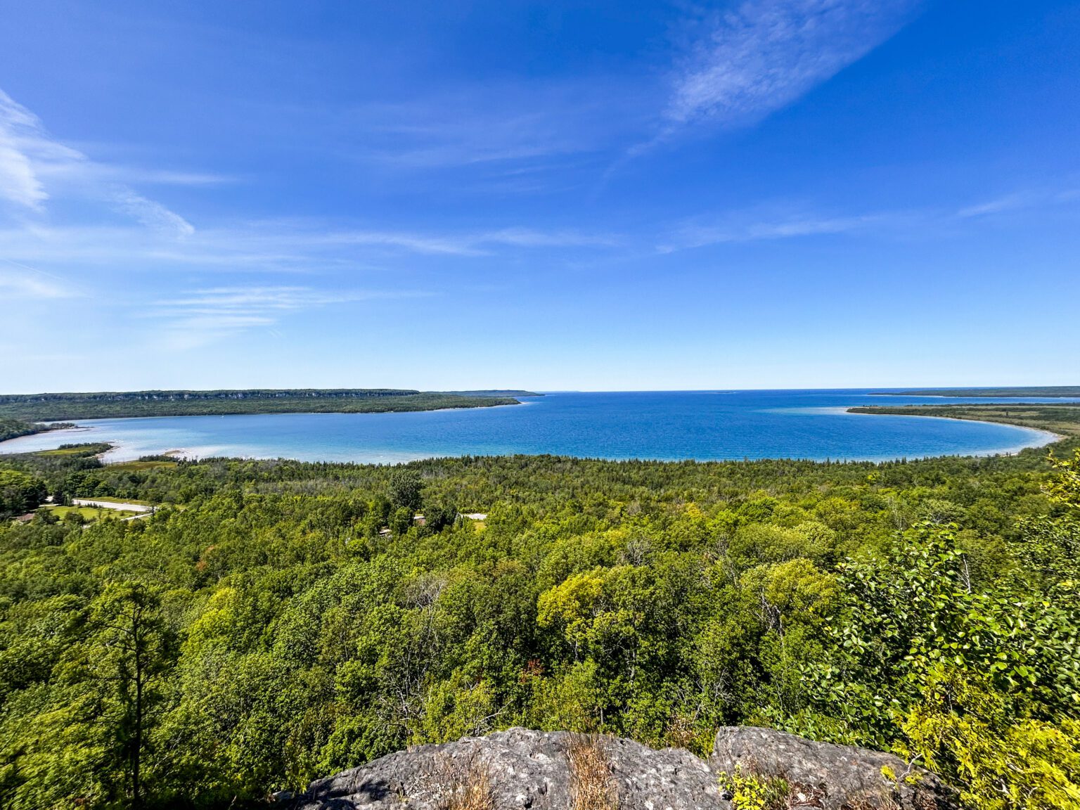
Peninsula BT Makeup Hike (km 15.6 – km 33.3)
https://hikes.brucetrail.org/event/peninsula-bt-makeup-hike-km-15-6-km-33-3/Sorry, the registration cut-off time for this hike has been reached.Not a member? Click here to join today!Hosting Club: Peninsula
Category: Peninsula BT Makeup Hike
Location (Google Maps):Hike Leader(s): Saabir Sohrab Click here to contact Hike Leader(s)
Pace: Medium (3.0 – 4.5 km/h): A comfortable pace for most hikers with steady progress.
Terrain: Difficult: Steep ascents/descents, rocky scrambling, and some rugged escarpment paths., Moderate: Rolling hills, mild slopes and rocky paths.
Distance: ~17.8Description
Wright’s Crescent to Cape Croker Park GateThis hike is part of the Peninsula BT Makeup Hikes, intended for hikers completing missed sections of the Peninsula Bruce Trail. Each hike requires individual registration.
To hike the entire Peninsula Section, please register for the Full Peninsula End-to-End Series (single registration for all 10 hikes): https://hikes.brucetrail.org/event/peninsula-end2end-in-10-series/2026-05-01/
Hikers may register for all 10 Makeup Hikes if they wish.
Expectations: Expect ~7 hours on the trail, depending on the terrain, weather, and group pace. The hike leader sets the pace, aiming for 3–4 km/h, and may adjust as needed for group ability and trail conditions. Breaks will be taken throughout the day.
For safety, participants must remain between the hike leader and the hike sweep at all times.
Meeting Time: 7:15 AM
Fees:
- Registration fee does Cape Croker Park’s parking fees
- Parking costs will be shared
- Fundraising: This hike is a fundraiser to support the Peninsula Bruce Trail Club’s volunteer-run hike program.
Participant Requirements
- Intermediate/experienced hikers with good fitness
- Proper hiking boots, layered clothing, wet weather gear
- Hiking poles recommended
- Bring: Lunch, snacks, water, bug spray
Transportation & Accommodations
- Car shuttle: Participants rotate as drivers; vehicles must be passenger-ready
- Accommodations: Book early; options include motels, campgrounds, hostels, and B&Bs
Note: Dogs are not permitted.
Quadzilla 3 series training hikes
https://hikes.brucetrail.org/event/quadzilla-3-series-training-hikes/Sorry, the registration cut-off time for this hike has been reached.Not a member? Click here to join today!Hike open to BTC Members only.
Hosting Club: Dufferin Hi-Land
Category: Cancelled
Location (Google Maps): Hockley Road and 5th line parking lotHike Leader(s): Tristan Goguen and Pat Foley Click here to contact Hike Leader(s)
Pace: Medium
Terrain: Slippery and Steep Sections
Distance: Approximately 25 KmDescription
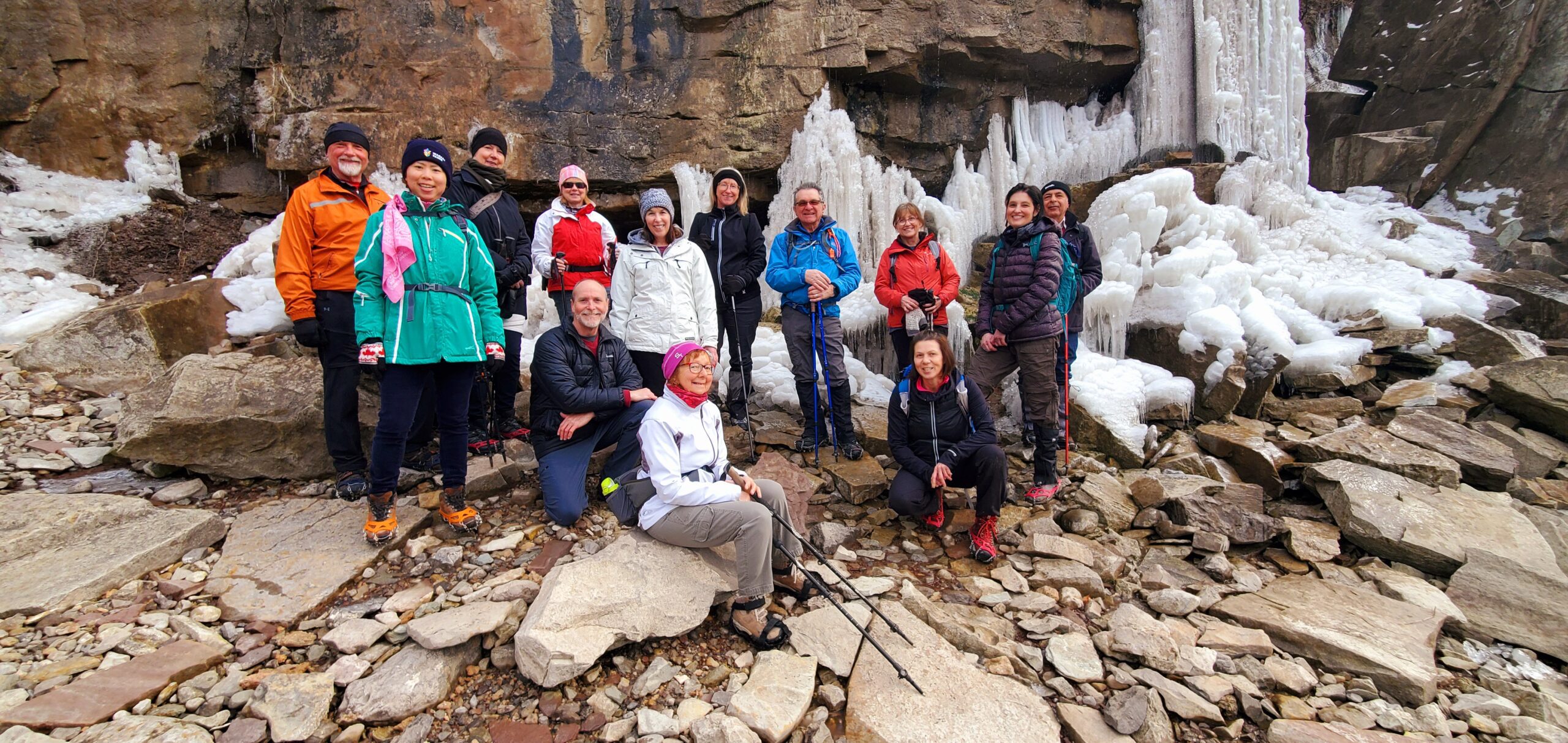
This series of hikes is designed to be for those who are familiar with hiking and want to start training for their summer hiking. The hike starts northbound up 5th line on the Hockley Heights side trail – a steep climb then into the woods – out along 15th side road down 3rd line to Dunby Rd and into the Hockley Valley Provincial Nature Reserve on the main trail. Once through the park we continue on the main trail up 2nd line then back along the main trail to the 5th line parking lot. For those not familiar with this series or section of the Caledon Hills… there are hills – plenty of them. At the beginning of April we can expect any of the following: ice, snow, mud and more mud… Come prepared for these conditions. Proper foot wear is a must, hiking poles are beneficial, rain/mud gear maybe necessary. There are no support stops for this hike so be sure to bring enough water, snacks and lunch. We will start out as a group but we fully expect hikers will divide up and go at their own pace. Everyone of course is welcome to stay in the main group with the hike leaders. If you cannot finish this distance you are encouraged not to attempt this hike it is a serious challenge. If you sign up for this hike please be respectful and if you have to drop out do so on line 2 days before the hike. Others maybe waiting for your spot and the hike leaders need to know you will be coming. We will provide a sign out sheet on the hike leader vehicle so you can sign out and note your time. This not only provides the hike leaders a safety check if you are a faster hiker but you can track your progress over the 3 hikes if you choose to do so.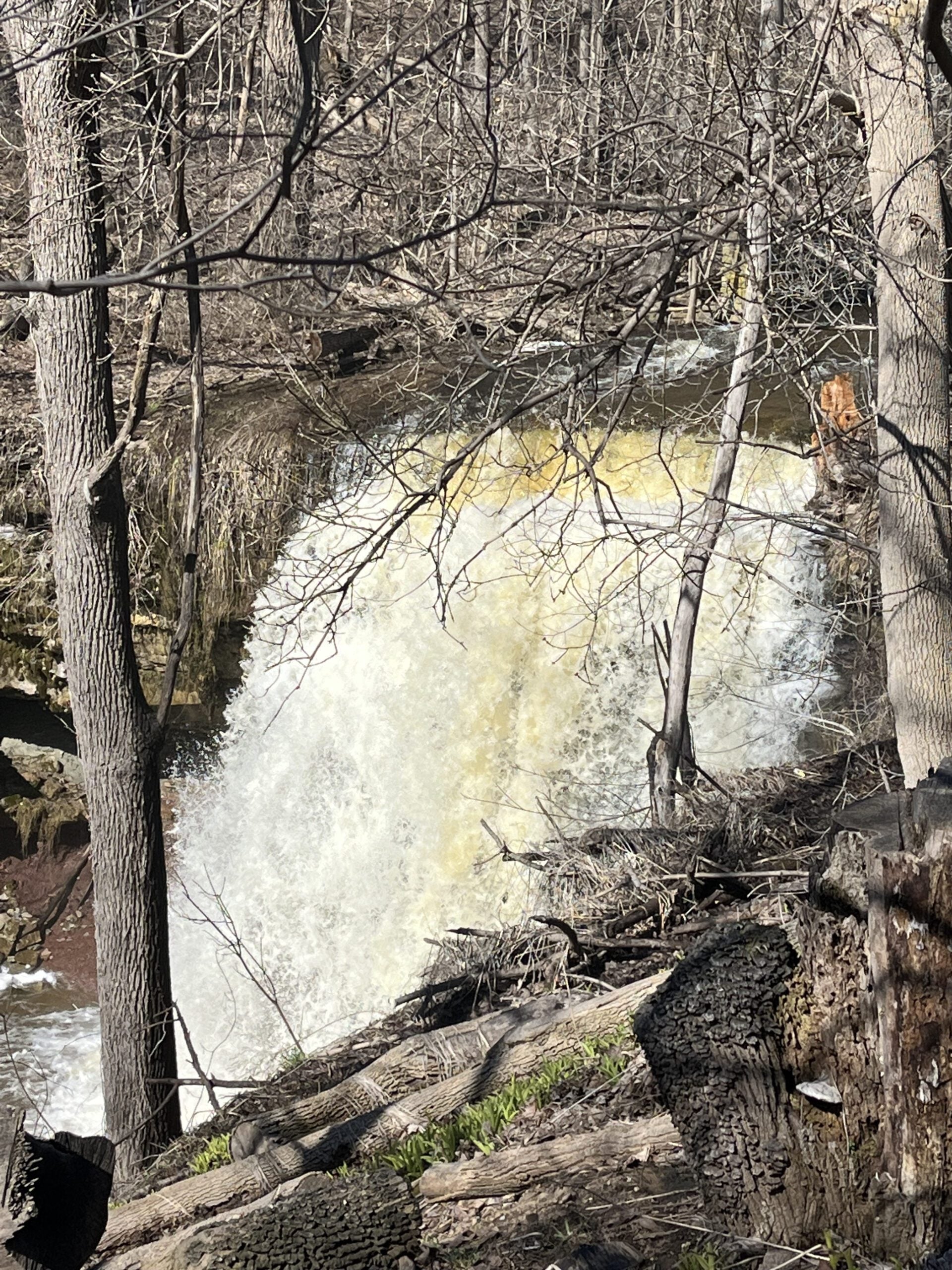
School Bus Hike: Iroquoia E2E #5 of 8
https://hikes.brucetrail.org/event/bus-hike-iroquoia-e2e-5-of-8/Sorry, the registration cut-off time for this hike has been reached.Not a member? Click here to join today!Trip Information
Departure Time: 08:30
Return to City Time: 18:00
Departure Point: Kipling Departure PointOptional Items
Hiking ($.01)Hosting Club: Toronto
Category: Bus Hike
Location (Google Maps): Dundas, ON to Waterdown, ONHike Leader(s): Tom Swales, David Royle Click here to contact Hike Leader(s)
Pace: Moderate (3-4 km/hr)
Terrain: Hilly, Level 2 (Intermediate – some hills and uneven surfaces, rocks and roots underfoot), Rocky, Variable
Distance (km): 14 kmDescription
We continue our Iroquoia section End-2-End series which we began in the Fall of 2025. Any capable hikers are welcome regardless if completing the End-2-End for one of the badges or not. Hikers can expect rocky portions and hills as the trail goes up and down the Niagara escarpment. The trail may be wet and muddy. We hope to maintain a steady pace of 4 km/hr. We resume whre we left off at Sydenham Lookout in Dundas. After 2,1/2 km we pass Rock Chapel Sanctuary and Borer’s Falls. We descend to Valey Road (4 km). After an asecent we continue along the escarpment to Old Guelph Rd/Hwy 6 (6 km). We continue through the Hwy 6 tunnel through Clappison Woods. and the steep ascent through Smokey Hollow to the Great Falls Lookout Point (12 km) where there will be an optional dropout. We continue another 2 km to King Road (14 km). We will reward our efforts with a refreshment stop in Waterdown, home of the Copper Kettle’s apple fritters. The distance may be modified according to our progress during the day.Car Hike: Bethesda Trail Richmond Hill 233
https://hikes.brucetrail.org/event/car-hike-bethesda-trail-richmond-hill-39/Sorry, the registration cut-off time for this hike has been reached.Not a member? Click here to join today!Hosting Club: Toronto
Location (Google Maps): Oak Ridges Corridor, Bethesda Trail Head Parking Lot, Bethesda Side Road, Richmond Hill, Ontario
Hike Leader(s): Mohammad Aghamiri Click here to contact Hike Leader(s)
Pace: Moderate (3-4 km/hr)
Terrain: Hilly, Level 2 (Intermediate – some hills and uneven surfaces, rocks and roots underfoot), Variable
Distance (km): 14-15 kmDescription
Join us to explore the trails of York Regional Forest and the Oak Ridges Corridor at Jefferson Forest and Bond lake,From parking lot we hike thought Jefferson forest and continue to Bond Lake and have snack beside the lake and return to parking around 13 to 13.30
Please bring lots of water and snacks ,hiking poles are recommended
phone number for the day of hike 289 588 6482

9:00 In & Around Port Weller East on Several Lakefront Trails
https://hikes.brucetrail.org/event/900-in-around-port-weller-east-on-several-lakefront-trails/Sorry, the registration cut-off time for this hike has been reached.Not a member? Click here to join today!Hosting Club: Niagara
Category: Loop
Location (Google Maps):Happy Rolph’s Animal Farm; 650 Read Rd., St Catharines
Hike Leader(s): Karen Couch Click here to contact Hike Leader(s)
Pace: Medium
Terrain: Easy
Distance: 7-8 kmsDescription
Starting at Happy Rolph’s Animal Farm, we will follow the 9/11 Memorial Walkway, then meander our way to trails maintained by the City of St. Catharines through open parkland, along Lake Ontario. We will then loop our way back through Happy Rolph’s. Birders may want to bring their binoculars.Please note: The animal viewing area is only open mid-May to Labour Day.
Niagara Glen Hike
https://hikes.brucetrail.org/event/niagara-glen-hike-7/Sorry, the registration cut-off time for this hike has been reached.Not a member? Click here to join today!Hosting Club: Niagara
Category: Loop
Location (Google Maps):Meet at the Niagara Glen Nature Centre parking lot, 3050 Niagara Parkway, Niagara Falls. This is located between the Whirlpool Golf Course and the Niagara Botanical Gardens, on the river side of the Niagara Parkway. Parking fees may apply.
Hike Leader(s): Dan Wilson Click here to contact Hike Leader(s)
Pace: Medium
Terrain: Strenuous
Distance: 10kmDescription
Hike deep in the Niagara Gorge, along stairways cut into the rock and rugged paths that wind through this pristine pocket of Carolinian Forest. View ancient geological formations and fossils dating back millions of years, while hiking along the turbulent rapids of the Niagara River. This is a strenuous hike and there is a chance hikers could get wet. Bring water, a snack, gaiters, hiking poles and icers, if necessary. Weather conditions at this time of year can change suddenly. Dress in layers. 🙂Car Hike: Caledon Rail Trail
https://hikes.brucetrail.org/event/car-hike-caledon-rail-trail-4/Sorry, the registration cut-off time for this hike has been reached.Not a member? Click here to join today!Hosting Club: Toronto
Category: Car Hike
Location (Google Maps):Caledon Rail Trail from Inglewood to Caledon East.
Hike Leader(s): Al Brown Click here to contact Hike Leader(s)
Pace: Moderate (3-4 km/hr)
Terrain: Flat, Level 1 (Easy – mostly on flat, well maintained trails with hard-packed surface)
Distance (km): 12 kmDescription
This is a hike for those who have been cooped up all winter and want to get back to hiking. We will meet in Caledon East and car pool to Inglewood to start the hike. We will have a refreshment stop after in local area.The meeting place will be in the parking lot west of the Caledon Town Hall, east of the community centre. Go north on Airport Road from King Road to Caledon East. Turn east onto Old Church Road. Proceed about 1 km to the meeting spot on your right.