Categories
- 12July 12, 2025
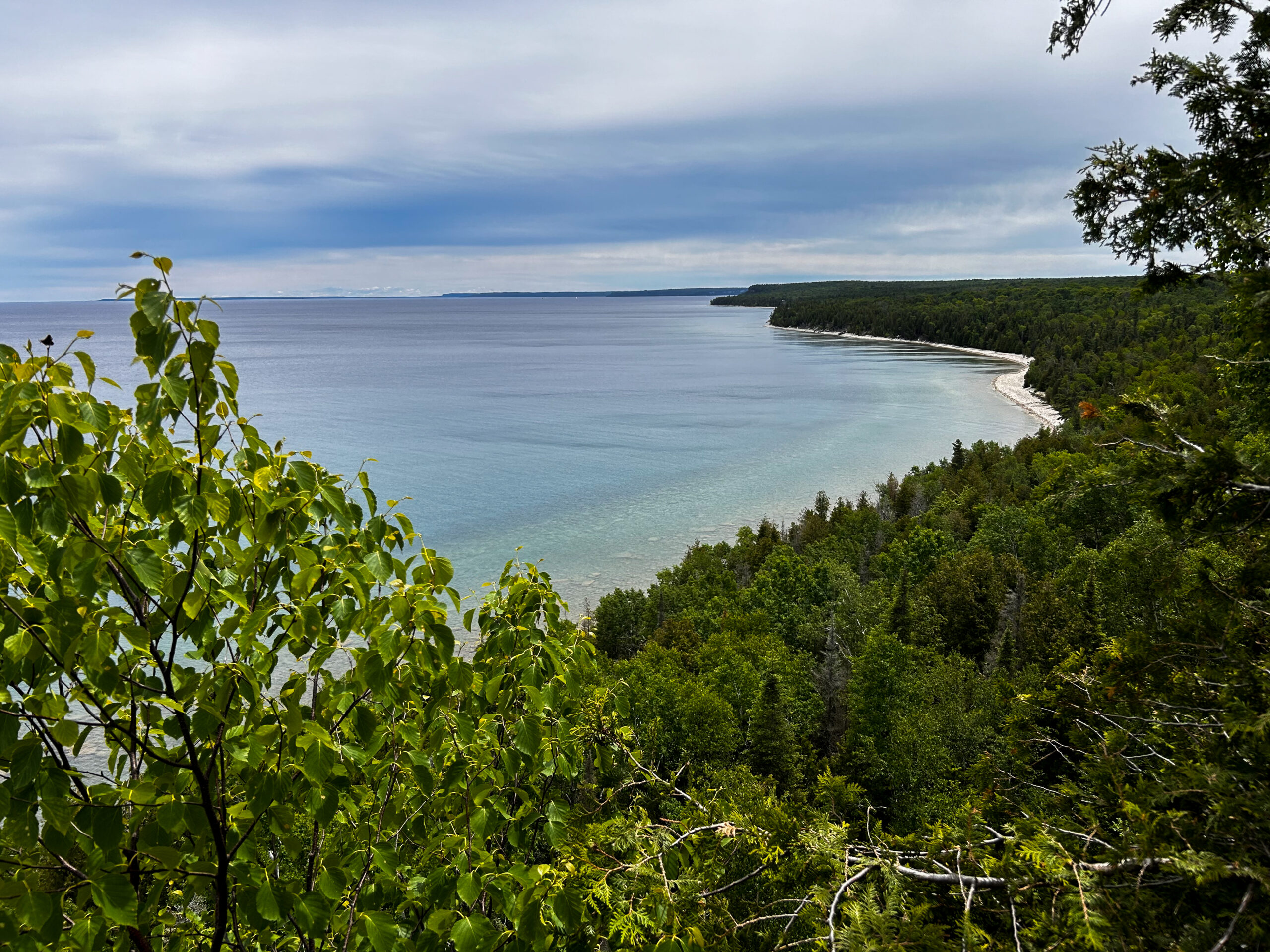
Peninsula Sunrise Series: Cape Chin South Shoreline
https://hikes.brucetrail.org/event/peninsula-sunrise-series-cape-chin-south-shoreline/Sorry, the registration cut-off time for this hike has been reached.Not a member? Click here to join today!Hosting Club: Peninsula
Category: Sunrise Hike
Location (Google Maps): Parking at South end of Carter Rd in Cape ChinHike Leader(s): Kathleen Stahlbaum Click here to contact Hike Leader(s)
Pace: Leisurely (2.0 – 3.0 km/h): A relaxed pace with frequent breaks and a focus on enjoyment.
Terrain: Moderate: Rolling hills, mild slopes and rocky paths.
Distance: 4kmDescription
Experience the magic of dawn on the Bruce Trail with the Sunrise Hike Series offered by the Peninsula Bruce Trail Club. These early morning hikes provide a perfect opportunity to awaken your senses, boost your energy, and immerse yourself in the tranquility of nature as the sun paints the sky with breathtaking hues. As we make our way through scenic forest trails, we’ll pause to witness the first light shimmering on the turquoise waters of Georgian Bay – a sight that will surely leave you in awe!Beyond the beauty, morning light helps regulate your circadian rhythm, elevating your mood, boosting energy levels and improving sleep quality. Whether you’re looking to start your day with a sense of calm, capture stunning sunrise photos, or simply reconnect with nature, these hikes offer a unique and inspiring way to greet the day.
On Saturday July 12th, join us in hiking along the Cape Chin Side Trail and Main Trail along the Cape Chin shoreline where we’ll experience the sun rising over the Bay from the shoreline. We’ll have the joy of taking in the stunning colours of the sky as the first light sparkles on the stunning turquoise waters. This peaceful sunrise hike is the perfect way to connect with nature, capture some incredible photos, and start the day with fresh air and inspiration. Whether you’re a morning person or just love a good adventure, come experience the magic of dawn from one of the best vantage points on the Bruce Peninsula!
Don’t forget to bring a headlamp or flashlight (preferably with a red light setting) as we begin our adventure in the pre-dawn quiet. Join us and discover how a sunrise hike can nourish your mind, body, and spirit—setting the tone for a brighter, more balanced day.
This hike is approximately 4 kms in length. Expect to be on the trail for ~2 hours. Pace will be leisurely with ample time to enjoy the sunrise, take some photographs, and nourish yourself!
How to prepare
- Get a good night’s sleep
- Bring lots of water and a snack (breakfast and/or coffee are recommended if that’s your thing!)
- Bring a headlamp or flashlight (preferably with a red light setting)
- Wear comfortable and supportive hiking boots
- Hiking poles are recommended but not necessary
- Bring insect repellant or wear protective clothing
Car Hike: Scotsdale Farm
https://hikes.brucetrail.org/event/car-hike-scotsdale-farm-13/Sorry, the registration cut-off time for this hike has been reached.Not a member? Click here to join today!Hosting Club: Caledon Hills
Category: General
Location (Google Maps): Scotsdale Farm, Map 13. Directions; from Highway 401, head north on Trafalgar Road past Georgetown. Trafalgar briefly merges with Highway 7 for about 3 km before separating to the right at the village of Silver Creek. At the stop light in Silver Creek, continue north on Trafalgar Road for about 1 km to the entrance of Scotsdale Farm on your right. Drive in about half a kilometre to reach the parking area.Hike Leader(s): Dylan “Lana” Hubbard Click here to contact Hike Leader(s)
Pace: Medium – 3 to 4 km/hour
Terrain: Moderate – some hills and/or some poor footing
Distance: 14 kmDescription
Join us for a loop hike along the main Bruce Trail and its scenic side trails, including the stunning Great Esker Side Trail. After the hike, if enough people are interested, we’ll gather at The Shepherd’s Crook in Georgetown for refreshments and good company.Please dress appropriately for the weather, bring plenty of water, and pack some snacks. Note that parts of the trail are rocky, so poles are highly recommended.
HIGHLY RECOMMEND BRINGING BUG SPRAY!
We are committed to fostering an inclusive and welcoming environment. This hike is an LGBTQ+ safe space, and everyone is encouraged to join us!
Hike 2 Blue Mountain Series in 6 Hikes
https://hikes.brucetrail.org/event/hike-2-blue-mountain-series-in-6-hikes/Sorry, the registration cut-off time for this hike has been reached.Not a member? Click here to join today!Hosting Club: Dufferin Hi-Land
Category: General Hike
Location (Google Maps): Meeting at Nottawasaga Bluffs Conservation Area Parking approx Km 21.9 NOTE THIS IS A PAID PARKING LOTHike Leader(s): Patricia Foley and Tristan Goguen Click here to contact Hike Leader(s)
Pace: Medium
Terrain: Moderate
Distance: 13.25 approximatelyDescription
Hike 2. We will car pool back to the start at Nottawasaga side Rd 9/10. Today we will hike from km 14.1 to km 26 on the unopened Nottawasaga Side Rd 15/16. We will hike back along the unopened road to the parking area adding approximately 1.25 Km.We will have the opportunity to explore the Keyhole side trail and Nottawasaga Bluffs lookout side trail.
We may encounter some muddy sections and will definitely be in open fields/roads for some time. Bug spray, sunblock and sturdy hiking shoes/boots are recommended. Bring sufficient water and lunch. Note this is a car pool hike, registration is limited and the hike leaders will have 2 dogs with them.
Car Hike: Rouge National park Scarborough195
https://hikes.brucetrail.org/event/car-hike-rouge-national-park-scarborough-6/Sorry, the registration cut-off time for this hike has been reached.Not a member? Click here to join today!Hosting Club: Toronto
Location (Google Maps): Free parking in mast trail parking Lot off Kingston Road
Hike Leader(s): Mohammad Aghamiri Click here to contact Hike Leader(s)
Pace: Moderate (3-4 km/hr)
Terrain: Hilly, Level 2 (Intermediate – some hills and uneven surfaces, rocks and roots underfoot), Variable
Distance: 14-15 kmDescription
We will hike Vista trail and part of orchard trail, will enjoy look outs between Rouge river and Little Rouge creek
• Please dress appropriately for the weather.
• We will have short water ,picture and a 15 minute snack break. Everyone is welcome!Beaver valley E2E hike #1/5
https://hikes.brucetrail.org/event/beaver-valley-e2e-hike-1-5/Sorry, the registration cut-off time for this hike has been reached.Not a member? Click here to join today!Hike open to BTC Members only.
Hosting Club: Toronto
Category: Car Hike
Location (Google Maps): Meet at Kolapore parking, south of km 23.8, Grey Rd 2. Coordinates N 44.422919,W 80.405597 map 25Hike Leader(s): Smadar Junkin Click here to contact Hike Leader(s)
Pace: Brisk (4-5 km/hr)
Terrain: Challenging, Hilly, Level 3 (Advanced – steep hills and some scrambling over boulders)
Distance: About 24kms. A little longer then the map shows because of a reroute.Description
This is the first of 5 consecutive days to complete the Beaver Valley section. Beaver Valley is beautiful and challenging section. Please note that these hikes are long and are at the height of summer. Please assess your ability to keep up with the pace and distance of these hikes series before registering.
we will shuttle to km 0.0 and hike back. Bring at least 2 litres of water, snacks and lunch. Bug repellent and sun screen.make sure to arrive at 8:15 for each hike so we can be in the cars and ready to go by 8:30. All participants need to drive car shuttles as many times as needed at the duration of these hikes. Please note that you need to register to each hike individually.
this is a no reply email. If you need to get in touch with me, please use my personal email address above.
School Bus Hike: Pathways To Port Dover Lynn Valley Trail
https://hikes.brucetrail.org/event/bus-hike-pathways-to-port-dover-lynn-valley-trail-3/Sorry, the registration cut-off time for this hike has been reached.Not a member? Click here to join today!Trip Information
Departure Time: 08:30
Return to City Time: 19:00
Departure Point: Kipling Departure PointOptional Items
Hosting Club: Toronto
Category: Bus Hike
Location (Google Maps):Lynn Valley Trail
Hike Leader(s): Tom Swales, Felix Wan Click here to contact Hike Leader(s)
Pace: Moderate (3-4 km/hr)
Terrain: Flat, Level 1 (Easy – mostly on flat, well maintained trails with hard-packed surface)
Distance: 12 kmDescription
Join us for a scenic and easy paced walk, a regular summer favorite along the trails running through Norfolk County from downtown Simcoe ending at historic Port Dover. The route is primarily on rail trails so is ideal for those who favor a flatter and easier route in the summer heat. Dropout at 8km. We will stop at the Simcoe Recreation Centre before the hike to use the facilities. After the hike there will be the opportunity to indulge in the local perch fish and chips or hang out at the beach which together make Port Dover famous. Long Distance Bus Fare applies and there will be a late return (after 6:00 Pm).Glen Huron to the keyhole
https://hikes.brucetrail.org/event/glen-huron-to-the-keyhole/Sorry, the registration cut-off time for this hike has been reached.Not a member? Click here to join today!Hosting Club: Blue Mountains
Category: Organized Hike
Location (Google Maps): Tim Horton’s First Street, CollingwoodHike Leader(s): David Little Click here to contact Hike Leader(s)
Pace: Medium – 3 to 4 km/hr
Terrain: Moderate – Some hills and/or some poor footing
Distance: 10kmDescription
We will park in Glen Huron near Station St and begin hiking west on the Ganaraska Trail to meet up with the white blazed trail at km 26.0. From here we head south heading towards the Nottawasaga Bluffs Conservation Area. After exploring the Keyhole Side Trail, we will loop around and back to the cars via the white blazed trail and
the Betty Carter Side Trail. Bring a snack or lunch and water. Parking: Concession 8 South and Station St.