Categories
- 31December 31, 2023
Urban Walk: Valley View Park Thornhill
https://hikes.brucetrail.org/event/urban-walk-valley-view-park-thornhill-9/Sorry, the registration cut-off time for this hike has been reached.Not a member? Click here to join today!Hosting Club: Toronto
Location (Google Maps): Parking lot at the corner of Bayview Ave, and Sycamore Dr. South of Highway 7
Hike Leader(s): Mohammad Aghamiri Click here to contact Hike Leader(s)
Pace: Moderate
Terrain: Variable
Distance: 7-8 KMDescription
We will explore Valleyview and Huntington park and walk along German Mill Creek,It is winter time and trail is hilly bring proper clothing, hiking boots and ice cleats.
Car Hike: Scotsdale Farm, New Year's Eve Hike
https://hikes.brucetrail.org/event/car-hike-scotsdale-farm-new-years-eve-hike/Sorry, the registration cut-off time for this hike has been reached.Not a member? Click here to join today!Hosting Club: Toronto
Category: Car Hike
Location (Google Maps): Scotsdale Farm, Map 13Hike Leader(s): Al Brown Click here to contact Hike Leader(s)
Pace: Moderate
Terrain: Variable
Distance: 8 KmDescription
This is a short end of year hike of about 2-3 hours after which all are invited to come to the Sheppard’s Crook in Georgetown for refreshments and to toast the end of the year and beginning of the new one.Trail conditions will be variable with muddy and frozen ground likely. Bring your icers just in case.
New Year's Eve potluck, hike and socialize
https://hikes.brucetrail.org/event/new-years-eve-potluck-hike-and-socialize/Sorry, the registration cut-off time for this hike has been reached.Not a member? Click here to join today!Hosting Club: Sydenham
Category: Hike & Potluck
Location (Google Maps): SNELs, 2888 3rd Ave. W., Owen SoundHike Leader(s): Bill & Audrey Snel Click here to contact Hike Leader(s)
Pace: Leisurely: 3 km/h or less
Terrain: Easy: Mostly flat and good footing.
Distance: 3 kmDescription
Meet at the SNELs starting at 5:30 pm. We will eat (potluck) at 6 pm. Supplied will be chili, coffee and tea. After stuffing ourselves we will go out for a 1-2 hour walk to aid digestion. A flashlight would be a good idea. On return we will socialize and enjoy some games while waiting for midnight. If unable to register or for information phone Bill or Audrey at (519) 470-0584. - 01January 1, 2024
Dunedin Nature Reserve
https://hikes.brucetrail.org/event/dunedin-nature-reserve/Sorry, the registration cut-off time for this hike has been reached.Not a member? Click here to join today!Hike open to BTC Members only.
Hosting Club: Blue Mountains
Category: Register in person the morning of hike.
Location (Google Maps): Hike meets in the parking lot behind Tim Hortons on First St. in Collingwood.Hike Leader(s): Hart Fischer Click here to contact Hike Leader(s)
Pace: Medium – 3 to 4 km/hr
Terrain: Moderate – Some hills and/or some poor footing
Distance: 8 kmDescription
We will drive to Dunedin Valley Nature Preserve parking on 6/7 Sideroad at Concession 10. Following the white blazed trail south on Concession 10, we enter the nature preserve on the east side. We will loop through the Dunedin Nature Reserve. This area covers mixed terrain and habitats. The trail follows along the banks of a tributary of the Noisy River in a loop back to Concession 10. After crossing Concession 10, we proceed through some farmers fields to a great view at the bench. Continuing across the field and down a hill to County Road 9, we will turn around and retrace our steps back to the cars. Bring a snack or lunch and water.Dufferin New Years Day Hike #1
https://hikes.brucetrail.org/event/dufferin-new-years-day-hike-1/Sorry, the registration cut-off time for this hike has been reached.Not a member? Click here to join today!Hosting Club: Dufferin Hi-Land
Category: General Hike
Location (Google Maps): Mono Centre Community Centre.Hike Leader(s): Stuart Law Click here to contact Hike Leader(s)
Pace: Medium
Terrain: Moderate
Distance: 10 kmsDescription
Walter Tovell ST there and back.10:30 New Years Day Long President’s Hike @ Fireman’s Park
https://hikes.brucetrail.org/event/1030-new-years-day-long-presidents-hike-firemans-park-2/Sorry, the registration cut-off time for this hike has been reached.Not a member? Click here to join today!Hosting Club: Niagara
Category: Loop
Location (Google Maps): Fireman’s Park – Upper Parking LotHike Leader(s): Sam Rutherford Click here to contact Hike Leader(s)
Pace: Medium
Terrain: Moderate
Distance: ~10kmsDescription
Join us for our annual New Year’s Day President’s Hike Celebration!This is the longer of two hikes available to register for – we will hike a loop around Fireman’s Park ~ 2.5 hours- 10:30am start. Pot luck New Years Celebration to follow under the gazebo @ 1:00pm- bring your favorite pot luck item to share!
Members who don’t want to hike can meet at 1:00pm at the gazebo for the Happy New Year celebration.
First Day (Brisk Pace) Hike - Hike Leaders – Karen Capindale-Smith, Joel Smith and Dave Salt
https://hikes.brucetrail.org/event/first-day-brisk-pace-hike-hike-leaders-karen-capindale-smith-joel-smith-and-dave-smart/Sorry, the registration cut-off time for this hike has been reached.Not a member? Click here to join today!Hosting Club: Iroquoia
Category: New Year’s Day Hike
Location (Google Maps): Dundas Valley Conservation Area (DVCA) at the Trail Centre 650 Governors Road, Dundas. The trail centre is the big red building which was the former train station about 200m from the parking lot.Hike Leader(s): Karen Capindale-Smith Click here to contact Hike Leader(s)
Pace: Brisk – 4 to 5 km/hr
Terrain: Dependent on Conditions, Moderate – Some hills and/or some poor footing, Strenuous – Hilly with steep climbs and some poor footing
Distance: 7-9kmDescription
Welcome to our annual Volunteer Appreciation Event! We welcome all volunteers, members and anyone who needs to start the new year off right – with a hike!Meet at the Dundas Valley Conservation Area (DVCA) at the Trail Centre by 10:45am for a 11am departure. Your hike leader(s) will lead you on an approximately 7-9km brisk-paced hike within the DVCA trails.
Iroquoia Bruce Trail Club Volunteer Appreciation Event will be taking place in the Trail Centre (big red building) at 1pm. All are welcome to join in the refreshments as we toast our incredible volunteers. There will be badges and other Iroquoia Bruce Trail swag available for purchase until it runs out (please bring small bills/toonies/loonies). We will have door prizes, as well.
Please dress for the weather forecast and bring your icers just in case.
Pay parking is in effect $11 per vehicle and driver unless you have a HCA Pass.
In the event of dangerous driving or trail conditions, this event will be postponed to January 6, 2024. It is important that everyone register.
Urban Walk: Leslie Spit (Tommy Thompson Park)
https://hikes.brucetrail.org/event/urban-walk-leslie-spit-tommy-thompson-park-2/Sorry, the registration cut-off time for this hike has been reached.Not a member? Click here to join today!Hosting Club: Toronto
Category: Urban Walk
Location (Google Maps): Tommy Thompson Park parking lot at the intersection of Leslie St and Unwin Ave (by park pavillion)Hike Leader(s): Andrew Proczek Click here to contact Hike Leader(s)
Pace: Leisurely
Terrain: Flat
Distance: 10-12 kmsDescription
Tommy Thompson Park ( Leslie Spit) is located at the intersection of Leslie St and Unwin Ave in Toronto. It is winter and the start of the new year so please dress accordingly. As we will be hiking near the lake it might be a little colder so dress for it. ICERS are advisable. The trail might be covered in a sheet of ICE, ( if you have them bring them with you ). Bring a snack, a hot drink, Water and any other essentials you will need for this outing.We will walk up to the light house and back. We meet in the sheltered area by the washrooms in the parking lot. Parking is FREE. Please arrive by about 15 minutes prior to the departure time of 11:00 AM as we will be leaving on time.

New Year’s Day Hike
https://hikes.brucetrail.org/event/new-years-day-hike/Sorry, the registration cut-off time for this hike has been reached.Not a member? Click here to join today!Hosting Club: Caledon Hills
Category: General
Location (Google Maps): Meet at the Bruce Trail Parking Lot on Mono 5 Sideroad on the north side of the road where the Trail crosses. Google GPS Coordinates: 43.974055, -79.984988Directions: From Airport Road turn east onto 5 Sideroad and drive for 600 metres. The parking lot is on the left hand side.
Hike Leader(s): Sandy Green Click here to contact Hike Leader(s)
Pace: Leisurely – 3 km/hour or less
Terrain: Easy – mostly flat and usually good footing
Distance: 1.5 or 3.5 or 5.5 kilometresDescription
Start 2024 on the right foot by joining our Club’s New Year’s Day Hike. Spend time with family and friends in nature. There is a distance for everyone’s enjoyment – 1.5, 3.5, or 5.5 kilometres. Hot chocolate and cookies will be served. Please bring your own cup. Hope to see you there!
First Day Children's Hike (Free Winter Junior Hiker Badge) Hike Leaders - Victoria Best and Cathie Green
https://hikes.brucetrail.org/event/first-day-childrens-hike-free-winter-junior-hiker-badge-hike-leaders-victoria-best-and-cathie-green/Sorry, the registration cut-off time for this hike has been reached.Not a member? Click here to join today!Hike open to BTC Members only.
Hosting Club: Iroquoia
Category: New Year’s Day Hike
Location (Google Maps): Dundas Valley Conservation Area (DVCA) at the Trail Centre 650 Governors Road, Dundas. The trail centre is the big red building which was the former train station about 200m from the parking lot.Hike Leader(s): Victoria Best Click here to contact Hike Leader(s)
Pace: Leisurely – 3km/hr or less
Terrain: Dependent on Conditions, Easy – Mostly flat and usually good footing
Distance: Approx 3-4kmDescription
Welcome to our annual Volunteer Appreciation Event! We welcome all volunteers, members and anyone who needs to start the new year off right – with a hike!Meet at the Dundas Valley Conservation Area (DVCA) at the Trail Centre by 11:15am for a 11:30am departure. Your hike leader(s) will lead you on an approximately 3-4km hike for families with children within the DVCA trails. Children under 13 participating in this hike will earn the Winter Junior Hiker Badge free of charge. https://www.iroquoia.on.ca/index.php/hiking/junior-hiker-program/
Iroquoia Bruce Trail Club Volunteer Appreciation Event will be taking place in the Trail Centre (big red building) at 1pm. All are welcome to join in the refreshments as we toast our incredible volunteers. There will be badges and other Iroquoia Bruce Trail swag available for purchase until it runs out (please bring small bills/toonies/loonies). We will have door prizes, as well.
Please dress for the weather forecast and bring your icers just in case.
Pay parking is in effect $11 per vehicle and driver unless you have a HCA Pass.
In the event of dangerous driving or trail conditions, this event will be postponed to January 6, 2024. It is important that everyone register.
One parent or guardian may register on behalf of everyone in your party. All children are expected to be accompanied by at least one parent or guardian.
New Year's Day Short President's Hike @ Firemen's Park
https://hikes.brucetrail.org/event/new-years-day-short-presidents-hike-firemens-park/Sorry, the registration cut-off time for this hike has been reached.Not a member? Click here to join today!Hosting Club: Niagara
Category: Loop
Location (Google Maps): Upper Parking Lot, Firemen’s Park, Niagara FallsHike Leader(s): janet davey Click here to contact Hike Leader(s)
Pace: Medium
Terrain: Moderate
Distance: 6 kmsDescription
Join us for our annual New Year’s Day President’s Hike Celebration!This is the shorter of two hikes available to register for – we will hike a loop around Firemen’s Park – 90 minutes – 11:30 am start. Pot luck New Year’s celebration to follow under the gazebo @ 1:00 pm – bring your favourite pot luck item to share!
Members who don’t want to hike can meet at 1:00 pm at the gazebo for the New Year’s celebration.

First Day (Medium Pace) Hike - Hike Leaders – Asia Shin and Colleen Mabalay
https://hikes.brucetrail.org/event/first-day-medium-pace-hike-hike-leaders-asia-shin-and-colleen-mabalay/Sorry, the registration cut-off time for this hike has been reached.Not a member? Click here to join today!Hosting Club: Iroquoia
Category: New Year’s Day Hike
Location (Google Maps): Dundas Valley Conservation Area (DVCA) at the Trail Centre 650 Governors Road, Dundas. The trail centre is the big red building which was the former train station about 200m from the parking lot.Hike Leader(s): Asia Shin Click here to contact Hike Leader(s)
Pace: Medium – 3 to 4 km/hr
Terrain: Dependent on Conditions, Moderate – Some hills and/or some poor footing
Distance: 4-6kmDescription
Welcome to our annual Volunteer Appreciation Event! We welcome all volunteers, members and anyone who needs to start the new year off right – with a hike!Meet at the Dundas Valley Conservation Area (DVCA) at the Trail Centre by 11:30am for a 11:45pm departure. Your hike leader(s) will lead you on an approximately 4-6k, medium-paced hike within the DVCA trails.
Iroquoia Bruce Trail Club Volunteer Appreciation Event will be taking place in the Trail Centre (big red building) at 1pm. All are welcome to join in the refreshments as we toast our incredible volunteers. There will be badges and other Iroquoia Bruce Trail swag available for purchase until it runs out (please bring small bills/toonies/loonies). We will have door prizes, as well.
Please dress for the weather forecast and bring your icers just in case.
Pay parking is in effect $11 per vehicle and driver unless you have a HCA Pass.
In the event of dangerous driving or trail conditions, this event will be postponed to January 6, 2024. It is important that everyone register.

Annual New Year's Day Loree Hike
https://hikes.brucetrail.org/event/annual-new-years-day-loree-hike/Sorry, the registration cut-off time for this hike has been reached.Not a member? Click here to join today!Hosting Club: Beaver Valley
Location (Google Maps): Meet at the municipal roadside parking on the 21st Sideroad by the road allowance entrance to Loree Forest, east of km 8.3, Map 24, Edition 31. (We will shuttle cars which don’t have a Town of Blue Mountains Municipal parking pass from 21st Sideroad & 4th Line to the hike start. Please contact the hike leader in advance to let her know if this is the case for you.)
Hike Leader(s): Margaret Yaraskavitch Click here to contact the hike leader.
Pace: Medium
Terrain: Easy, Moderate
Length of Hike: 6 kmDescription
Start the new year with a great walk in the woods with other Bruce Trail hikers. If there is a lot of snow, we will snowshoe up the road allowance and then loop the flat section of Loree Forest. If the conditions are better for icers or just boots, we’re add another small loop that is picturesque and has elevation change. Bring sufficient water and dress according to the weather.COVID-19 Precautions Before, During and After your Hike
- Each hiker joining a Bruce Trail Club organized hike must perform a self-screening check before hiking.
Find Ontario’s self-assessment tool here: https://covid-19.ontario.ca/self-assessment/ - If you are experiencing COVID-19 symptoms, stay home.
Other Guidelines
- Arrive 15 minutes before the start of the hike.
- Wear sturdy footwear and appropriate attire for the weather and the terrain.
Hiking poles are a good idea in any season, especially if the terrain is rocky or slippery. In winter, snowshoes or icers/crampons are needed when conditions dictate.
Wearing appropriate clothing and footwear prevents injuries and shows consideration for a safe and positive group hiking experience. - Always carry I.D. and your health card.
- Bring sufficient water and snacks (or lunch if indicated). A minimum of 1L of water is recommended on all hikes, and 3L is recommended for long, challenging hikes in the heat of the summer.
- Bring sunscreen and insect repellent (for spring and summer hikes).
- Bring your own first aid kit.
- Please leave dogs at home.

First Day (Leisurely Pace) Hike - Hike Leaders –Janina Vanderpost and Ruth Moffatt
https://hikes.brucetrail.org/event/first-day-leisurely-pace-hike-hike-leaders-janina-vanderpost-and-ruth-moffatt/Sorry, the registration cut-off time for this hike has been reached.Not a member? Click here to join today!Hosting Club: Iroquoia
Category: New Year’s Day Hike
Location (Google Maps): Dundas Valley Conservation Area (DVCA) at the Trail Centre 650 Governors Road, Dundas. The trail centre is the big red building which was the former train station about 200m from the parking lot.Hike Leader(s): Janina Vanderpost Click here to contact Hike Leader(s)
Pace: Leisurely – 3km/hr or less
Terrain: Dependent on Conditions, Easy – Mostly flat and usually good footing
Distance: Approximately 3-4kmDescription
Welcome to our annual Volunteer Appreciation Event! We welcome all volunteers, members and anyone who needs to start the new year off right – with a hike!Meet at the Dundas Valley Conservation Area (DVCA) at the Trail Centre by 11:45am for a 12pm departure. Your hike leader(s) will lead you on an approximately 3-4km hike within the DVCA trails.
Iroquoia Bruce Trail Club Volunteer Appreciation Event will be taking place in the Trail Centre (big red building) at 1pm. All are welcome to join in the refreshments as we toast our incredible volunteers. There will be badges and other Iroquoia Bruce Trail swag available for purchase until it runs out (please bring small bills/toonies/loonies). We will have door prizes, as well.
Please dress for the weather forecast and bring your icers just in case.
Pay parking is in effect $11 per vehicle and driver unless you have a HCA Pass.
In the event of dangerous driving or trail conditions, this event will be postponed to January 6, 2024. It is important that everyone register.
Dufferin Hi-Land Annual New Years Day Hike
https://hikes.brucetrail.org/event/dufferin-hi-land-annual-new-years-day-hike-5/Sorry, the registration cut-off time for this hike has been reached.Not a member? Click here to join today!Hosting Club: Dufferin Hi-Land
Category: General Hike
Location (Google Maps):Dufferin Hi-Land, Map 19. Meet at the Mono Community Centre parking lot. Take Mono Centre Road east from Hwy 10 and look for the Community Centre on your right as you approach the stop sign in Mono Centre.
Hike Leader(s): Tom Thayer;Les Babbage Click here to contact Hike Leader(s)
Pace: Leisurely
Terrain: Dependent on Conditions, Slippery Sections Likely
Distance: 4.8 or 7.5 kmDescription
Join us for a “day after the night before” hike to clear your head with a little exercise, fresh air and great company. Hot beverages and snacks available after the hike. Contributions to the snack table welcome!
Snow shoes or icers may be required, depending on conditions. Contact the hike leader if in doubt.
New Year’s Day Hike & Potluck
https://hikes.brucetrail.org/event/new-years-day-hike-potluck/Sorry, the registration cut-off time for this hike has been reached.Not a member? Click here to join today!Hosting Club: Sydenham
Category: Hike & Potluck
Location (Google Maps):294 Park Street, Georgian Bluffs
Hike Leader(s): Robert Knapp Click here to contact Hike Leader(s)
Pace: Medium: 3 to 4 km/h
Terrain: Moderate: Some hills and/or poor footing
Distance: 6 kmDescription
Start the year off correctly by enjoying a 6 km snowshoe/hike followed by a potluck supper at the Knapps. If it is stormy, then we will hike closer to the meeting place. Approx. 2.5 hour hike.Due to limited space, the potluck is open to Sydenham Bruce Trail Club members only, limit 20 people. Please call or email Bob and Marie Knapp at 519-371-1255 or rmknapp@yahoo.com to confirm your attendance at the potluck.
- Each hiker joining a Bruce Trail Club organized hike must perform a self-screening check before hiking.
- 02January 2, 2024
9:00 Long Hike Wiley Road Short Hills
https://hikes.brucetrail.org/event/900-long-hike-wiley-road-short-hills-19/Sorry, the registration cut-off time for this hike has been reached.Not a member? Click here to join today!Hosting Club: Niagara
Category: Loop
Location (Google Maps):Short Hills Wiley Road Entrance
Hike Leader(s): Alan Laver Click here to contact Hike Leader(s)
Pace: Medium
Terrain: Moderate
Distance: 10kmDescription
Explore Short Hills and the majestic side trails of Scarlett Tanager, Hemlock. Swayze Falls and Terrace. Register for each hike
Bring Poles water, snack, Icers and dress for the weather
9:15 Short hike, Pelham Road, Short Hills
https://hikes.brucetrail.org/event/915-short-hike-pelham-road-short-hills-70/Sorry, the registration cut-off time for this hike has been reached.Not a member? Click here to join today!Hosting Club: Niagara
Category: Loop
Location (Google Maps): Pelham Road entrance, Short Hills Provincial ParkHike Leader(s): janet davey Click here to contact Hike Leader(s)
Pace: Medium
Terrain: Moderate
Distance: 6 kmsDescription
Hike the main and side trails of Short Hills Provincial Park. Bring hiking boots, icers and water.
Beaver Valley Winter E2E (New Badge)
https://hikes.brucetrail.org/event/beaver-valley-winter-e2e-new-badge/Sorry, the registration cut-off time for this hike has been reached.Not a member? Click here to join today!This is a Multi-Day Hike
You are signing up for the following dates:
2024-01-02, 2024-01-09, 2024-01-23, 2024-01-30, 2024-02-13, 2024-02-20, 2024-03-05, 2024-03-12Hosting Club: Beaver Valley
Location (Google Maps): First hike will meet at km 13.7 on Sixth Line (please do not block farmers gates or laneways when parking)
Map 24, ED 31
We will car pool to km 0 on Maple Lane and hike back to our cars at 13.7Hike Leader(s): Kristina Rettie Click here to contact the hike leader.
Pace: Brisk, Medium
Terrain: Some rocky footing, Some steep sections, Strenuous
Length of Hike: hikes range between 13km-19km (conditions will determine pace, be prepared for anything between 3-5km/hr)Description
Welcome to our first ever Beaver Valley Winter End 2 End!In this series of 8 hikes you will get a chance to test your strength, endurance and perseverance! You will be rewarded with the breathtaking views of winter in the valley, good company and of coarse a NEW BADGE!!!
This E2E is intended for strong hikers/experienced snowshoers only. We will be hiking at a steady pace with very few short breaks to be sure we keep warm. As we need to be prepared for variable weather conditions, you will be required to carry icers and snowshoes with you on each hike. It will be tough hiking so be sure of your physical ability before signing up for this hike. If the snow is deep, please be prepared to take a turn blazing trail.
This will be a team effort from start to finish! Who wants to join the team?
As we all know Mother Nature can throw us curve balls at times. I will ask each hiker to please respect the decisions of the leader in case of inclement weather/road & parking conditions. We may need to adjust our meeting location and possibly postpone the hike.
Make sure to dress accordingly with the weather conditions presented on hike day.
A hike schedule will be sent to registered participants.
Due to parking restrictions we will only be accepting 12 hikers including the hike leader.
The Beaver Valley Winter E2E is a club lead series that can only be completed with a club leader.
All hikes in this series will include a car shuttle and everyone will take a turn as a shuttle driver. Please have your vehicle passenger ready.
If you have any questions please text me (Kristina) @ 519-410-9077 (this is the most efficient way)
Please bring plenty of water and snacks/lunch
No dogs
Please text Kristina @ 519-410-9077 for morning of cancelations
COVID-19 Precautions Before, During and After your Hike
- Each hiker joining a Bruce Trail Club organized hike must perform a self-screening check before hiking.
Find Ontario’s self-assessment tool here: https://covid-19.ontario.ca/self-assessment/ - If you are experiencing COVID-19 symptoms, stay home.
Transportation
It is the Bruce Trail Conservancy’s current policy that car shuttles are allowed. It is at the discrepancy of individual hike leaders to make that decision.
Other Guidelines
- Arrive 15 minutes before the start of the hike.
- Wear sturdy footwear and appropriate attire for the weather and the terrain.
Hiking poles are a good idea in any season, especially if the terrain is rocky or slippery. In winter, snowshoes or icers/crampons are needed when conditions dictate.
Wearing appropriate clothing and footwear prevents injuries and shows consideration for a safe and positive group hiking experience. - Always carry I.D. and your health card.
- Bring sufficient water and snacks (or lunch if indicated). A minimum of 1L of water is recommended on all hikes, and 3L is recommended for long, challenging hikes in the heat of the summer.
- Bring sunscreen and insect repellent (for spring and summer hikes).
- Bring your own first aid kit.
- Please leave dogs at home.
Rock Hill/Oliver Creek Loop
https://hikes.brucetrail.org/event/rock-hill-oliver-creek-loop/Sorry, the registration cut-off time for this hike has been reached.Not a member? Click here to join today!Hosting Club: Dufferin Hi-Land
Category: Tuesday Hike
Location (Google Maps):Dufferin Hi-Land, Map 20. Meet at Rock Hill parking lot on 1st Line Mulmur, just south of 10 Sideroad (Km 29.4).
Hike Leader(s): Les Babbage, Inge Eckerich, Julie Daley, Tony Evangelista Click here to contact Hike Leader(s)
Pace: Leisurely
Terrain: Slippery and Steep Sections, Moderate
Distance: 7.0 km; Short Hike: 2.4 kmDescription
We will hike the Main Trail, returning by way of the Oliver Creek and Moss Haven Side Trails. The short hike will return to parking from just past the top of the Enchanted Forest Side Trail, before the Main Trail descends into the Boyne Valley. Snowshoes or icers will likely be required, depending on conditions. Bring water and snacks.Culham Trail - Streetsville
https://hikes.brucetrail.org/event/culham-trail-streetsville-3/Sorry, the registration cut-off time for this hike has been reached.Not a member? Click here to join today!Hosting Club: Caledon Hills
Category: Car Hike
Location (Google Maps):Vic Johnston Community Centre – Church St., Streetsville (Park in the lower lot near ball diamond).
From Hwy 401 come south on Mississauga Rd. Pass Argentia Rd. and, at the next lights, turn left to stay on Mississauga Rd. Follow 3 km into Streetsville (where Mississauga Rd. becomes Queen St.) and turn left on Church St. OR,
From QEW or Hwy 403 come north on Erin Mills Pkwy, then – just south of Erin Mills Town Centre Mall – turn right on Eglinton, then left at lights on to Mississauga Rd. Follow for 2 km to right turn at Church St.
If you get lost phone Peter’s cell 905-301-4091Hike Leader(s): Peter Leeney
GPS Location: 43.5800, -79.70878Hike Leader(s): Peter Leeney Click here to contact Hike Leader(s)
Pace: Moderate
Terrain: Flat
Distance: 10 kmDescription
We will walk north along the Credit River for 4 km and then continue into the Credit Meadows Park for a 2 km loop. We will then return by the same route to our starting point in Streetsville. - Each hiker joining a Bruce Trail Club organized hike must perform a self-screening check before hiking.
- 03January 3, 2024
8:30 Niagara Winter End to End #1 Grimsby to Kinsman Park
https://hikes.brucetrail.org/event/830-niagara-winter-end-to-end-1-grimsby-to-kinsman-park-3/Sorry, the registration cut-off time for this hike has been reached.Not a member? Click here to join today!Hosting Club: Niagara
Category: Car Pool
Location (Google Maps): Meet Kinsmen Park Frost Rd Beamsville. Carpool to Lions Pool Grimsby 43.193201 79.565301Hike Leader(s): Sam Rutherford Click here to contact Hike Leader(s)
Pace: Medium
Terrain: Moderate
Distance: 13.5kmsDescription
We will be car pooling, Bring Icers and poles. No dogs. To earn your Niagara Winter End to End badge, it must be completed between December 21, 2022 to March 21, 2023.
Because of the potential for bad winter trail conditions we have broken this e2e into 6 hikes rather than 5Black Ash Creek ST Fern Crevice loop
https://hikes.brucetrail.org/event/balsam-side-trail-loop/Sorry, the registration cut-off time for this hike has been reached.Not a member? Click here to join today!Hosting Club: Blue Mountains
Category: Register in person the morning of hike.
Location (Google Maps): Hike meets in the parking lot behind Tim Hortons on First St. in Collingwood.Hike Leader(s): Kelly-Leigh Thomas Click here to contact Hike Leader(s)
Pace: Medium – 3 to 4 km/hr
Terrain: Moderate – Some hills and/or some poor footing
Distance: 8.5 kmDescription
We will drive to the Black Ash Creek Side Trail parking lot on the 2nd Line (Parking fee: $10). This will be a hike to recognize and celebrate our Indigenous peoples. We will start on this new side trail and then pick up the white blazed trail in the Petun Conservation Area. We will continue along until we cross the road at the Russ McConnell Side Trail. Following the side trail we reconnect with the white blazed trail taking us around the escarpment to take in all the views. We will continue on to the John Haigh Side Trail.There will be a little hiking on the road to get back to the cars. Bring a snack and water.
9:00 am NBTC Side Trail Challenge #8 - Margaret Reed
https://hikes.brucetrail.org/event/900-am-nbtc-side-trail-challenge-8-margaret-reed/Sorry, the registration cut-off time for this hike has been reached.Not a member? Click here to join today!Hosting Club: Niagara
Category: In and Out
Location (Google Maps): Cave Springs Conservation Area parking lotHike Leader(s): Robin Garrett Click here to contact Hike Leader(s)
Pace: Brisk
Terrain: Moderate
Distance: 9 kDescription
Take Margaret Reed side trail to main trail and hike to Mountain Road and back. Required photo: Margaret Reed side trail sign. Participate in all 9 scheduled hikes in the NBTC Side Trail Challenge or hike the side trails on your own. Submit your photos to collect the NBTC Side Trail badge.Burlington Beachfront
https://hikes.brucetrail.org/event/burlington-beachfront-3/Sorry, the registration cut-off time for this hike has been reached.Not a member? Click here to join today!Hosting Club: Iroquoia
Category: Good Companions
Location (Google Maps):Burlington Public Library, Central Branch, off New Street. Parking lot directly behind the library.
Hike Leader(s): Gayle Laws Click here to contact Hike Leader(s)
Pace: Medium – 3 to 4 km/hr
Terrain: Easy – Mostly flat and usually good footing
Distance: 8 kmDescription
Meeting at 9:15 am for a 9:30 am start, in the parking lot directly behind the Central Branch, Burlington Public Library. An urban hike. We will take the footpath towards the lake front, through Spencer Park and along the lake towards the canal lift bridge. The temperature and weather will determine how far we will go as winds from the lake can be cold and strong. Bring fluids and a snack.Winter Wednesday Walkers - Margaret Paull Loop
https://hikes.brucetrail.org/event/winter-wednesday-walkers-margaret-paull-loop/Sorry, the registration cut-off time for this hike has been reached.Not a member? Click here to join today!Hosting Club: Beaver Valley
Location (Google Maps): Meet on 6th Line, north of Grey Road 119 (also called Sideroad 15), km 13.7, Map 24, Edition 31. Do not block driveway, gate or farm entrance.
Hike Leader(s): Glenda Collings Click here to contact the hike leader.
Pace: Medium
Terrain: Moderate, Some steep sections
Length of Hike: Approx. 4 kmDescription
This will be a fairly short, but lovely loop, as we hike into the woods, past a flowerpot created by the waves of an ancient glacial lake, along Indian Creek and through fields with views. On winter hikes we may encounter bare ground, light snow, deep snow, or ice. Please bring snowshoes and icers to our Winter Wednesday Walkers outings. Wear appropriate clothing for the weather plus water and a snack.COVID-19 Precautions Before, During and After your Hike
- Each hiker joining a Bruce Trail Club organized hike must perform a self-screening check before hiking.
Find Ontario’s self-assessment tool here: https://covid-19.ontario.ca/self-assessment/ - If you are experiencing COVID-19 symptoms, stay home.
Other Guidelines
- Arrive 15 minutes before the start of the hike.
- Wear sturdy footwear and appropriate attire for the weather and the terrain.
Hiking poles are a good idea in any season, especially if the terrain is rocky or slippery. In winter, snowshoes or icers/crampons are needed when conditions dictate.
Wearing appropriate clothing and footwear prevents injuries and shows consideration for a safe and positive group hiking experience. - Always carry I.D. and your health card.
- Bring sufficient water and snacks (or lunch if indicated). A minimum of 1L of water is recommended on all hikes, and 3L is recommended for long, challenging hikes in the heat of the summer.
- Bring sunscreen and insect repellent (for spring and summer hikes).
- Bring your own first aid kit.
- Please leave dogs at home.
Discovery Hike - GSCA to Inglis Falls
https://hikes.brucetrail.org/event/discovery-hike-gsca-to-inglis-falls/Sorry, the registration cut-off time for this hike has been reached.Not a member? Click here to join today!Hosting Club: Sydenham
Category: General Hike
Location (Google Maps): Meet in the parking lot behind the Grey-Sauble Conservation Authority head office.
237897 Inglis Falls Road, Owen SoundHike Leader(s): Jeannine Kralt Click here to contact Hike Leader(s)
Pace: Leisurely: 3 km/h or less
Terrain: Moderate: Some hills and/or poor footing
Distance: 4 kmDescription
Enjoy an outing during the winter break. This hike is suitable for families, and new hikers or individuals looking for a more leisurely pace. This hike will generally follow the main trail from the GSCA to Inglis Falls and back. Map 32.On Discovery Hikes, we see what we can find along the way. Topics may include geology, history, or flora and fauna depending on interest. Participants can feel free to point things out or ask questions as we explore along the trail. We’ll check out how this stretch of trail differs now as compared to other seasons.
This trail generally has enough use that, unless there is notable snowfall in the preceding 24 hours, I don’t anticipate the need for snowshoes. Should you want to try out snowshoes or hiking poles, the Owen Sound library has some available to borrow. There are some uphill portions along this hike (we’ll take our time), and there may be some slippery or mucky patches depending on conditions. Suitable winter footwear is a must. Unfortunately dogs can not attend these guided hikes.
Bring a snack, and look forward to checking out the Sydenham River Valley in winter!
Carpooling may be available, upon request.
Please click the link to get in touch if you have any questions, or are having difficulty with registration.
Evening Owen Sound Hike to view the Festival of Northern Lights followed by an Opportunity for Refreshments
https://hikes.brucetrail.org/event/evening-owen-sound-hike-to-view-the-festival-of-northern-lights-followed-by-an-opportunity-for-refreshments/Sorry, the registration cut-off time for this hike has been reached.Not a member? Click here to join today!Hosting Club: Sydenham
Category: An evening walk.
Location (Google Maps): Meet in the municipal parking lot by the river on the west side of 1st Ave. E between 7th St. E and 8th St. E in Owen Sound.Hike Leader(s): Harriet Nixon Click here to contact Hike Leader(s)
Pace: Brisk: 4 to 5 km/h
Terrain: Easy: Mostly flat and good footing., There might be icy and slippery sections.
Distance: Approx 5 kmDescription
Join us in Owen Sound to view the Festival of Northern Lights in the River District and Harrison Park followed by an opportunity for refreshments. Bring icers in case of icy conditions. There is no need to arrive at 6:45 pm, but this hike will start at 7:00 pm. For further information call Hike Leader Harriet Nixon at 519-373-6598 or harrietnixon@bmts.com - Each hiker joining a Bruce Trail Club organized hike must perform a self-screening check before hiking.
- 04January 4, 2024
Urban Walk: Valley View Park Thornhill
https://hikes.brucetrail.org/event/urban-walk-valley-view-park-thornhill/Sorry, the registration cut-off time for this hike has been reached.Not a member? Click here to join today!Hosting Club: Toronto
Category: Urban Walk
Location (Google Maps): Parking lot at the corner of Bayview Ave, and Sycamore Dr. South of Highway 7Hike Leader(s): Mohammad Aghamiri Click here to contact Hike Leader(s)
Pace: Moderate
Terrain: Variable
Distance: 7-8 KMDescription
We will explore Valleyview and Huntington park and walk along German Mill Creek,It is winter time and trail is hilly bring proper clothing, hiking boot sand ice cleats.
9:00 am Long Hike Jordan to Moyer / Louth
https://hikes.brucetrail.org/event/900-am-long-hike-jordan-to-moyer-louth-51/Sorry, the registration cut-off time for this hike has been reached.Not a member? Click here to join today!Hosting Club: Niagara
Location (Google Maps):
Jordan Hollow Park 3039 King St Jordan
Pace: Medium
Terrain: Moderate
: 10kDescription
From Jordan Hollow Hike the main trail to Upper and Lower Balls Falls, Moyer Road or Louth and Return. You must register for each hike. Bring Poles, sunscreen, bug spray , snack and a drink and dress for the weather
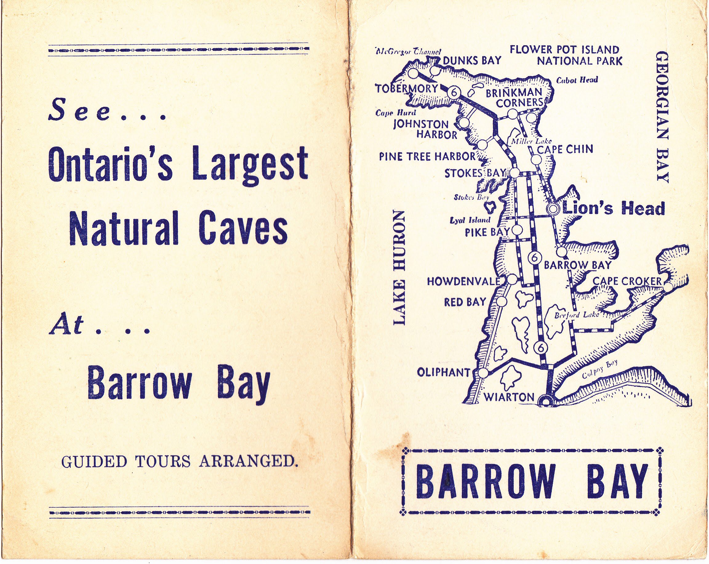
History & Hot Chocolate in Barrow Bay
https://hikes.brucetrail.org/event/history-hot-chocolate-in-barrow-bay/Sorry, the registration cut-off time for this hike has been reached.Not a member? Click here to join today!Hosting Club: Peninsula
Location (Google Maps): Bruce Trail Parking lot in Barrow Bay (the old one, just south of West Shore Road)
Hike Leader(s): Leslie McBeth Click here to contact Hike Leader(s)
Pace: Leisurely
Terrain: Moderate
Distance: ~5kmDescription
On this hike, you’ll learn a little about the history of the storied hamlet of Barrow Bay. The traditional keepers of this land are the Anishinabek Nation: The People of the Three Fires known as Ojibway, Odawa, and Pottawatomie Nations. In the late 19th century, Barrow Bay because the hub of the lumber industry, and then eventually was settled by cottagers. We’ll tell stories about the old hotel that once stood on the Bruce Trail Palmer Property, and look out over Little Lake to learn of the mysterious serpent once told to inhabit the dark waters below. Then we’ll see if we can spot the old dam on Judges Creek and learn about the sawmill that once stood here. Then after the hike, hikers are invited to enjoy some hot chocolate (provided) by the campfire and share your own stories of adventures on the Saugeen (Bruce) Peninsula.Note that we’ll be walking a short distance on the road, as well as covering rocky terrain, which can be slippery, especially in the winter. Icers or crampons are recommended. Dress in layers appropriate for the weather. Rain date TBD.
9:15 Short Hike - Jordan Hollow
https://hikes.brucetrail.org/event/915-short-hike-jordan-hollow-90/Sorry, the registration cut-off time for this hike has been reached.Not a member? Click here to join today!Hosting Club: Niagara
Category: Loop
Location (Google Maps): Jordan Hollow Park, Jordan StationHike Leader(s): Bill Russell Click here to contact Hike Leader(s)
Pace: Medium
Terrain: Moderate
Distance: 6kDescription
Hike the main and side trails around Jordan and Ball’s Falls. Bring hiking boots, water and icers. - 05January 5, 2024

Queenston Heights Tour
https://hikes.brucetrail.org/event/queenston-heights-tour/Sorry, the registration cut-off time for this hike has been reached.Not a member? Click here to join today!Hosting Club: Niagara
Category: Loop
Location (Google Maps): Meet near the Queenston Heights Restaurant, Niagara ParkwayHike Leader(s): Margaret Northfield Click here to contact Hike Leader(s)
Pace: Medium
Terrain: Easy
Distance: 5-7kmDescription
Hike around Queenston Heights park and the beginning of the Bruce Trail.Margaret & Robin
- 06January 6, 2024
CANCELLED: Winter Coach Trip, Arrowhead Provincial Park
https://hikes.brucetrail.org/event/winter-coach-trip-arrowhead-provincial-park-2/Sorry, the registration cut-off time for this hike has been reached.Not a member? Click here to join today!Hosting Club: Toronto
Category: Cancelled
Location (Google Maps): Arrowhead Provincial ParkHike Leader(s): Martina Furrer, Roland Mark, Celia Ho Click here to contact Hike Leader(s)
Description
Cancelled due to lack of snow and a low number of registrants.No trail fees at Arrowhead! Bus cost includes park admission.
Bus departs 10 York Mills Rd at 8:00 AM and Major Mackenzie Dr and HWY 400 Park and Ride at 8:20 AM. If you wish to be picked up at the Major Mackenzie Dr and HWY 400 Park and Ride, select that option when you register. Please arrive 15 minutes before departure. The bus waits for no one.
Join us for an awesome day of winter fun at Arrowhead Provincial Park. For information about trail conditions visit: https://www.ontarioparks.com/skireport. For information about the park visit: https://www.ontarioparks.com/park/arrowhead. Join Roland and Celia for a guided snowshoe hike, or enjoy self-guided skiing on trails groomed for classic and skate skiing. After skiing or snowshoeing spend some time ice skating (if open) in the forest.
There are no food services in the park. Pack water/tea and lunch.
Ski and snowshoe rentals available.
Coach fares and park admission must be paid online when you register. Masks are mandatory on the bus.

A Winter Toronto E2E - Fundraiser Hike for the Limehouse Arch Stained Glass Badge
https://hikes.brucetrail.org/event/a-winter-toronto-e2e-fundraiser-hike-for-the-limehouse-arch-stained-glass-badge/Sorry, the registration cut-off time for this hike has been reached.Not a member? Click here to join today!This is a Multi-Day Hike
You are signing up for the following dates and times:
2024-01-06 at 08:15
2024-01-13 at 08:15
2024-01-20 at 08:15Hosting Club: Iroquoia, Toronto
Category: Special Event
Location (Google Maps): Toronto section E2E Led by Dave SaltHike Leader(s): Dave Salt Click here to contact Hike Leader(s)
Pace: Brisk – 4 to 5 km/hr
Terrain: Dependent on Conditions, Moderate – Some hills and/or some poor footing, Slippery Sections Likely
Distance: Varies each day – section is just under 50km in totalDescription
This is a fundraiser hike and end to end of the Toronto section in 3 outings. There are no refunds. After the finish, you will earn the special Toronto stained glass badge. You are registering for 3 days, January 6, 13 and 20th.
Hikers will need to complete the three hikes with the leader but are allowed to miss one hike and make it up on their own before the last scheduled hike. Please keep a log of the missed hike and give it to the leader on the last day.The fee goes towards supporting the Toronto Bruce Trail Club, which in turn supports the mission of the Bruce Trail Conservancy “preserving a ribbon of wilderness, for everyone, forever”.
Registration for this hike is limited to members of the Bruce Trail Conservancy.
This hike is intended to be Moderate (4k per hour). Register only if you are capable of sustaining this pace for the day over a varied rocky & snowy terrain.Hikers are expected to follow the COVID 19 guideline and stay home if they have symptoms.
Hikers may choose to wear masks.
Arrive 15 minutes early, wear sturdy footwear, ice cleats, proper layers for winter weather, always carry ID cards, bring 2 litres of water, bring your own first aid kit.
Something warm to drink at our lunch break would be a good idea!
Hikers should anticipate winter conditions – boots, icers, poles, gators, layered clothing, water, snacks, lunch, first aid kit. We will take turns shuttling from meeting place to trailhead each day and a driver will need to take the shuttle drivers back to their car at the end of the hike. We will meet each day at 8:15 and shuttle to trailhead – hikers should arrive 15 minutes early to ensure ready to leave at 8:30. Anticipate most hikes will take approx 5-6 hours including lunch and snack breaks.
Please ensure you are physically able to manage the pace, distance and potential wintery conditions & temperatures of this hike before registering. Refunds are not allowed. Your fee includes the badge.
The hike leader may change a hike date due to inclement winter conditions.Location:Day-1: (Google Maps): Km 17.4, Fourth Line. East side of the road. Coordinates N 43.615163,W 79.975157
Distance:17.4
Day-2: km 32.2 east side of 8th 8th line, at 27th sideroad intersection. Coordinates N 43.686276, W 79.975578
Day-3: km 48.3 on Boston Mills Rd, west of Mississauga Rd intersection. Coordinates N 43.750866 W 79.951452
Great Niagara Circle Route #5 Miller to Niagara Falls
https://hikes.brucetrail.org/event/great-niagara-circle-route-5-miller-to-niagara-falls/Sorry, the registration cut-off time for this hike has been reached.Not a member? Click here to join today!Hosting Club: Niagara
Category: Car Pool
Location (Google Maps):Meet at Aerocar Parking Lot Niagara Falls. Car Pool to Niagara Boulevard and Miller Road,
Hike Leader(s): Alan Laver Click here to contact Hike Leader(s)
Pace: Brisk
Terrain: Easy
Distance: 14.3Description
The Greater Niagara Circle Route badge is awarded to walkers who independently complete the Circle Route Trail i.e. Lock 1 Port Weller, along the Welland Canal to Port Colborne , following the Friendship Trail to Fort Erie, following the Niagara Recreational Parkway Trail to Niagara-on-the-Lake and following the Waterfront Trail to Port Weller.
Car Hike: Hike of 2 lakes King city 116
https://hikes.brucetrail.org/event/car-hike-hike-of-2-lakes-king-city-10/Sorry, the registration cut-off time for this hike has been reached.Not a member? Click here to join today!Hosting Club: Toronto, Dufferin Hi-Land
Location (Google Maps): Park along Fairfield Dr. or Dufferin Street. Gather at trail head on Dufferin Street.
Hike Leader(s): Mohammad Aghamiri Click here to contact Hike Leader(s)
Pace: Moderate
Terrain: Variable
Distance: 14-17KMDescription
We will hike in trails around Seneca lake and Mary Lake, pass by Eaton Hall and visit Pine farm where you can enjoy coffee, tea and apple pie during our snack time.Some safety procedures during the hike:
1-Hikers must stay between the leader and the sweep,
2-Hikers must advise the leader or the sweep if they wish to leave the group.
3- Hikers must follow the whistle instructions: 1 blast- stay where you are; 2 blasts come to the leader; 3 blasts – come to the leader quickly.
4-Hike leader may request volunteers to stop at trail intersections, they need to help hikers to the direction the group walk and wait till they see the sweep .
5-Hikers have to make sure they can see the persons behind and in front of them.
Standing Rock-Singhampton Caves
https://hikes.brucetrail.org/event/metcalfe/Sorry, the registration cut-off time for this hike has been reached.Not a member? Click here to join today!Hosting Club: Blue Mountains
Category: Register in person the morning of hike.
Location (Google Maps): Hike meets in the parking lot behind Tim Hortons on First St. in Collingwood.Hike Leader(s): Allison Thomas Click here to contact Hike Leader(s)
Pace: Medium – 3 to 4 km/hr
Terrain: Strenuous – Hilly with steep climbs and some poor footing
Distance: 8.5Description
Oarking at the Lower Pretty Ver parking lot, we will head out along the new reroute trail that will take us over to the Pretty River where we ill follow it to the Clearview Townline. We will ascend this very steep road to the 30/31 sideroad. Entering here we will have another significant climb weaving our way up to Standing Rock Side Trail where the trail becomes challenging up and over icy rock faces and through icy cracks and crevices. Be prepared for a difficult wet or icy climb dependent on the most recent weather conditions. Crampons a must. Snowshoes if weather permits. Once at the top we will close the loop. Bring a snack or lunch and water.
Map: 22/23 Edition 30 Pace: MediumCar Hike; Awenda Provincial Park
https://hikes.brucetrail.org/event/car-hike-awenda-provincial-park/Sorry, the registration cut-off time for this hike has been reached.Not a member? Click here to join today!Hike open to BTC Members only.
Hosting Club: Toronto
Category: Car Hike
Location (Google Maps): Meet in front of Trail and Activity CenterHike Leader(s): Roland Mark Click here to contact Hike Leader(s)
Pace: Moderate
Terrain: Variable
Distance: 14 to 16 kmDescription
Hike will begin at 9:30 am. We’ll be staying mainly on the Bluff and Wendat Trails. We’ll head north on Brule Trail from the Trail Center to the Bluff Trail and turn eastward and hike to and around Kettle Lake and back to the Bluff Trail. Th hike will continue south alongtheu Bluff Trail and back to the Trail Center.It will be cold and possibly windy this Saturday so please dress warmly and in layers. Bring a lunch, snacks and 2L of liquid for hydration.
Niagara Gorge, American side
https://hikes.brucetrail.org/event/niagara-gorge-american-side/Sorry, the registration cut-off time for this hike has been reached.Not a member? Click here to join today!Hosting Club: Niagara
Category: Loop
Location (Google Maps): Whirlpool State Park, Niagara Falls, NYHike Leader(s): Marion Hanover Click here to contact Hike Leader(s)
Pace: Medium
Terrain: Moderate
Distance: 10kmDescription
Let’s explore the Niagara gorge from the American side. Proper documentation needed to cross into the United States. I will arrange a car pool from St Catharines Glendale Carpool lot at 9:00am if there is an interested.Woodford Escarpment Loop
https://hikes.brucetrail.org/event/woodford-escarpment-loop-7/Sorry, the registration cut-off time for this hike has been reached.Not a member? Click here to join today!Hosting Club: Sydenham
Category: Snowshoe Hike
Location (Google Maps): Meet in the north-east corner of the parking lot at Home Depot on Highway 26 on the east side of Owen Sound.Hike Leader(s): Franziska Edney Click here to contact Hike Leader(s)
Pace: Medium: 3 to 4 km/h
Terrain: Moderate: Some hills and/or poor footing, There might be icy and slippery sections.
Distance: 3 kmsDescription
This is a 3 km loop, taking us by an old lime kiln, through a forested area, over a creek, up and down a few hills and through crevices (which can be avoided). If interested, we can add another 1.5 kms and hike or snowshoe the crevice Springs Loop across the road. Poles are advised. Please remember that Woodford often has more snow than Owen Sound. It is a good idea to bring both, snow shoes and grippers. Map 30. Please contact the Leader, if you have questions or are not car pooling at 519 379 2573.