Categories
- 11December 11, 2022
Sunday Rambles
https://hikes.brucetrail.org/event/sunday-rambles-2/Sorry, the registration cut-off time for this hike has been reached.Not a member? Click here to join today!Hike open to BTC Members only.
Hosting Club: Iroquoia
Category: General Hike
Location (Google Maps): Ancaster Little League Park – 286 Jerseyville Rd W Ancaster (across from the Ancaster Lions Outdoor Pool)Hike Leader(s): Colleen Mabalay Click here to contact Hike Leader(s)
Pace: Medium – 3 to 4 km/hr
Terrain: Strenuous – Hilly with steep climbs and some poor footing
Distance: Approx. 10kDescription
We will follow the Spring Valley Trail, Martins Road, Headwaters Trail etc. in the western part of the Dundas Valley. Bring water and a snack (poles would also be useful).2:00pm Glenridge Quarry Loop
https://hikes.brucetrail.org/event/200pm-glenridge-quarry-loop/Sorry, the registration cut-off time for this hike has been reached.Not a member? Click here to join today!Hike open to BTC Members only.
Hosting Club: Niagara
Category: Loop
Location (Google Maps): Glenridge Quarry parking lot, St. David’s Rd., Map 3Hike Leader(s): Larry Lloyd Click here to contact Hike Leader(s)
Pace: Leisurely
Terrain: Easy
Distance: 6 kmDescription
A combination of open trails with spectacular views across Lake Ontario and wooded trails including the main trail. - 12December 12, 2022
9:00 Hiking in and around Rotary Park
https://hikes.brucetrail.org/event/900-hiking-in-and-around-rotary-park-9/Sorry, the registration cut-off time for this hike has been reached.Not a member? Click here to join today!Hosting Club: Niagara
Location (Google Maps): 395 Pelham Road, regional Road 69, St. Catharines
Hike Leader(s): Sheila Massey Click here to contact Hike Leader(s)
Pace: Medium
Terrain: Moderate
Distance: 6-7 kmDescription
Hiking various trails in and around Rotary Park and along 12 Mile CreekEasy Monday Hikes
https://hikes.brucetrail.org/event/easy-monday-hikes-3/Sorry, the registration cut-off time for this hike has been reached.Not a member? Click here to join today!Hosting Club: Peninsula
Location (Google Maps): Cape Hurd Alvar Bay Nature Reserve – located at 745 Cape Hurd Road about 20 minutes south of Tobermory. Follow Cape Hurd Road west, past MacArthur Road. After the curve on the road, travel about 1 km. Cape Hurd Alvar Bay Nature Reserve is located on the west side of the road. Roadside parking.
Hike Leader(s): Marg Glendon
Pace: Leisurely
Terrain: Easy
Distance: ~2 kmDescription
Easy hikes are short hikes (<3 KM) that are generally flat with little elevation change and mostly clear of tree roots and rocks. Hikes are adjusted according to weather conditions. Footwear with good tread and ankle support are recommended. Hiking poles are recommended, but not required. Bring a small backpack to carry water and light snacks.We will begin our hike at the roadside and walk along the Cape Hurd Reserves Nature Trail to the shoreline. The shoreline is rocky, explore the shoreline at your comfort level. The Cape Hurd Alvar Nature Reserve is home to rare species such as the Massasauga Rattlesnake, Little Brown Myotis Bat and the Eastern Wood-Pewee. We will have a nutrition break at the shoreline and retrace our steps to the beginning of our hiie.
Learn more about Cape Hurd Alvar Nature Reserve here: https://escarpment.ca/see-our-reserves/bruce-county-and-huron-shore/cape-hurd-alvar-bay
Minimum group size- 4
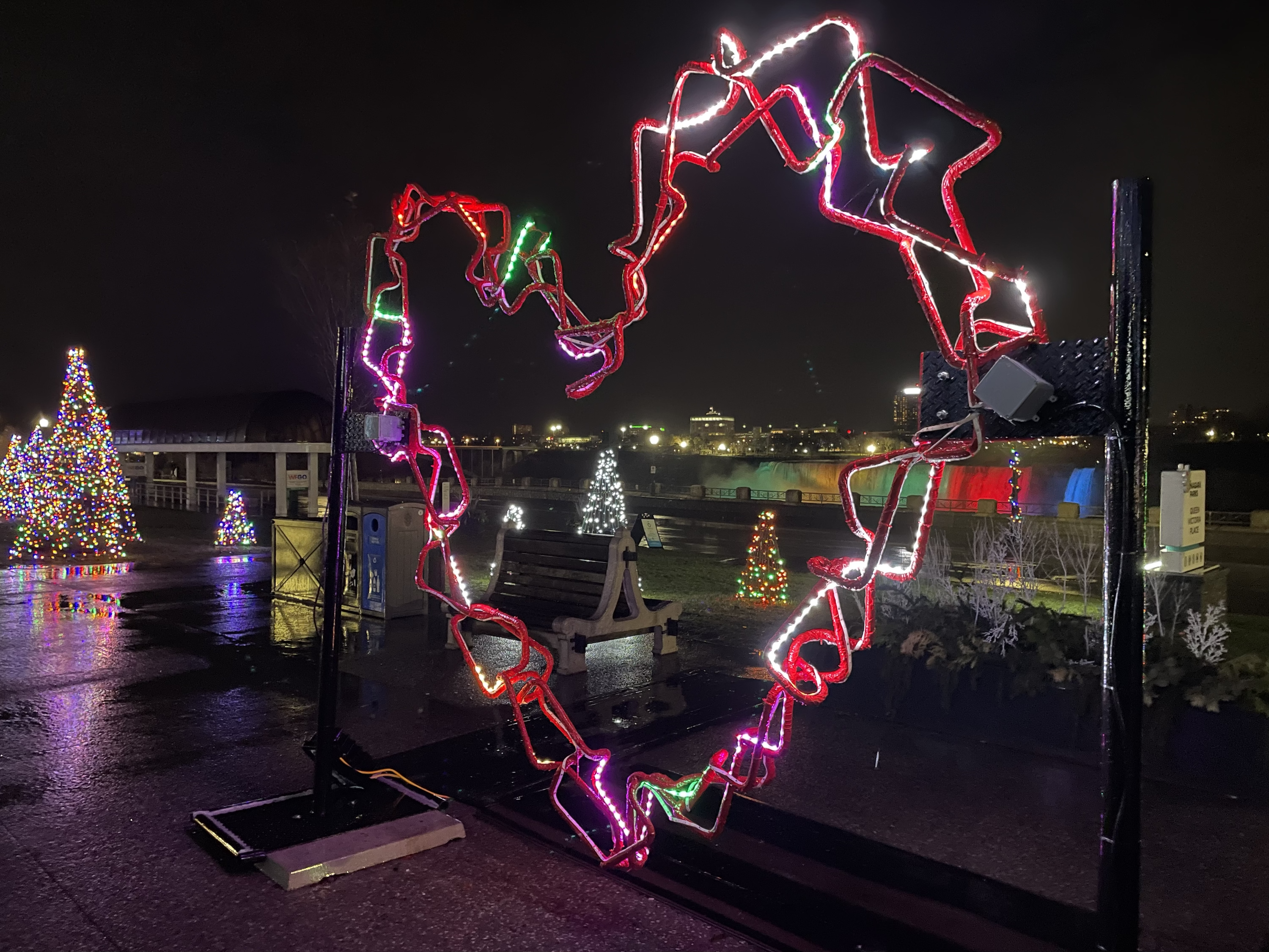
19:00 Winter Festival of Lights
https://hikes.brucetrail.org/event/1900-winter-festival-of-lights/Sorry, the registration cut-off time for this hike has been reached.Not a member? Click here to join today!Hosting Club: Niagara
Category: Night
Location (Google Maps): Floral Showhouse, Niagara Parkway, just south of the FallsHike Leader(s): Margaret Northfield Click here to contact Hike Leader(s)
Pace: Leisurely
Terrain: Easy
Distance: 5-6kmDescription
Get your cameras ready for the Annual Winter Festival of Lights hike. Get into a festive mood with a walk around the Falls for this annual event. Stay afterwards for hot apple cider and festive treats. Feel free to share your favourite treats. - 13December 13, 2022
9:00 NEW VENUE Rockway Conservation
https://hikes.brucetrail.org/event/900-new-venue-rockway-conservation-2/Sorry, the registration cut-off time for this hike has been reached.Not a member? Click here to join today!Hosting Club: Niagara
Location (Google Maps): Rockway Conservation Area
Pelham Road, St CatherinesPace: Medium
Terrain: Moderate
: 10kmDescription
Changing it up for December only.Hike the trails in and around Rockway towards Louth or effingham
9:15 Short hike, Pelham Road, Short Hills
https://hikes.brucetrail.org/event/915-short-hike-pelham-road-short-hills-29/Sorry, the registration cut-off time for this hike has been reached.Not a member? Click here to join today!Hosting Club: Niagara
Location (Google Maps): Pelham Road entrance, Short Hills Provincial Park
Hike Leader(s): janet davey Click here to contact Hike Leader(s)
Pace: Medium
Terrain: Moderate
Distance: 6 kmsDescription
Hike the main and side trails in Short Hills. Bring hiking boots and water.Maple Lane into Loree
https://hikes.brucetrail.org/event/maple-lane-into-loree/Sorry, the registration cut-off time for this hike has been reached.Not a member? Click here to join today!Hosting Club: Beaver Valley
Location (Google Maps): Park at km 0 of the Beaver Valley section on Maple Lane (please do not block driveways)
Hike Leader(s): Kristina Rettie Click here to contact the hike leader.
Pace: Brisk
Terrain: Moderate, Some steep sections
Length of Hike: 8.5kmDescription
This is an in and out hike that will take us up along the top of the ski hill and into Loree forest. It will start off fairly easy to get our legs warmed up then some steep climbs to the top of Loree. We will take a much deserved break before retracing our step back to our cars.Please be prepared with icer’s and/or snowshoes (depending on conditions we may shorten hike)
Bring snack and water. Please no dogs.
COVID-19 Precautions Before, During and After your Hike
- Each hiker joining a Bruce Trail Club organized hike must perform a self-screening check before hiking.
Find Ontario’s self-assessment tool here: https://covid-19.ontario.ca/self-assessment/ - If you are experiencing COVID-19 symptoms, stay home.
- Personal Protective Equipment:
- Hikers may choose to wear masks
Transportation
It is the Bruce Trail Conservancy’s current policy that car shuttles are allowed. It is at the discrepancy of individual hike leaders to make that decision.
Other Guidelines
- Arrive 15 minutes before the start of the hike.
- Wear sturdy footwear and appropriate attire for the weather and the terrain.
Hiking poles are a good idea in any season, especially if the terrain is rocky or slippery. In winter, snowshoes or icers/crampons are needed when conditions dictate.
Wearing appropriate clothing and footwear prevents injuries and shows consideration for a safe and positive group hiking experience. - Always carry I.D. and your health card.
- Bring sufficient water and snacks (or lunch if indicated). A minimum of 1L of water is recommended on all hikes, and 3L is recommended for long, challenging hikes in the heat of the summer.
- Bring sunscreen and insect repellent (for spring and summer hikes).
- Bring your own first aid kit.
- Please leave dogs at home.
Culham Trail - Streetsville
https://hikes.brucetrail.org/event/culham-trail-streetsville-2/Sorry, the registration cut-off time for this hike has been reached.Not a member? Click here to join today!Hosting Club: Caledon Hills
Category: Car Hike
Location (Google Maps): Vic Johnston Community Centre – Church St., Streetsville (Park in the lower lot near ball diamond).
From Hwy 401 come south on Mississauga Rd. Pass Argentia Rd. and, at the next lights, turn left to stay on Mississauga Rd. Follow 3 km into Streetsville (where Mississauga Rd. becomes Queen St.) and turn left on Church St. OR,
From QEW or Hwy 403 come north on Erin Mills Pkwy, then – just south of Erin Mills Town Centre Mall – turn right on Eglinton, then left at lights on to Mississauga Rd. Follow for 2 km to right turn at Church St.
If you get lost phone Peter’s cell 905-301-4091Hike Leader(s): Peter Leeney Date: November 16, 2021
GPS Location: 43.5800, -79.70878Hike Leader(s): Peter Leeney Click here to contact Hike Leader(s)
Pace: Moderate
Terrain: Flat
Distance: 8 kmDescription
We will walk north along the Credit River for 4 km and then return by the same route. - Each hiker joining a Bruce Trail Club organized hike must perform a self-screening check before hiking.
- 14December 14, 2022
Blue Mountains Section E2E #2 in a series of 6 hikes
https://hikes.brucetrail.org/event/blue-mountains-section-e2e-2-in-a-series-of-6-hikes/Sorry, the registration cut-off time for this hike has been reached.Not a member? Click here to join today!Hosting Club: Blue Mountains
Category: Register on-line or sign-in morning of hike
Location (Google Maps): Hike meets in the parking lot behind Tim Hortons on First St. in Collingwood.Hike Leader(s): Hart Fischer Click here to contact Hike Leader(s)
Pace: Medium – 3 to 4 km/hr
Terrain: Moderate – Some hills and/or some poor footing
Distance: 10kmDescription
Hike starts at Km 11.9-km 21.9 (10km) We will park the cars at km 21.9 and car shuttle to km 11.9 to begin the hike. Drumlins, spoon-shaped mounds of glacial sand and gravel, can be seen to the right of the trail (snow permitting). The trail follows several rocky crevices and passes through forests and fields. It meets an old logging road, which it follows across a field and through some wet areas and enters a mature cedar forest with Escarpment cliffs. Bring a snack or lunch and water. Map 22 Ed. 30Burlington Beachfront
https://hikes.brucetrail.org/event/burlington-beachfront-2/Sorry, the registration cut-off time for this hike has been reached.Not a member? Click here to join today!Hosting Club: Iroquoia
Category: Good Companions
Location (Google Maps): Burlington Public Library, Central Branch, off New Street. Parking lot directly behind the library.Hike Leader(s): Gayle Laws Click here to contact Hike Leader(s)
Pace: Medium – 3 to 4 km/hr
Terrain: Easy – Mostly flat and usually good footing
Distance: 8 kmDescription
Meeting at 9:15 am for a 9:30 am start, in the parking lot directly behind the Central Branch, Burlington Public Library. An urban hike. We will take the footpath towards the lake front, through Spencer Park and along the lake towards the canal lift bridge. The temperature and weather will determine how far we will go as winds from the lake can be cold and strong. Bring fluids and a snack.The Glen to the Ron Savage Side Trail
https://hikes.brucetrail.org/event/the-glen-to-the-ron-savage-side-trail/Sorry, the registration cut-off time for this hike has been reached.Not a member? Click here to join today!Hosting Club: Sydenham
Category: General Hike
Location (Google Maps): The Galaxy Theatre parking lot. Meet in the parking lot at the tall “Galaxy Centre” sign next to the traffic lights.
1020 10th St. W., Owen SoundHike Leader(s): Maureen McFarland Click here to contact Hike Leader(s)
Pace: Medium: 3 to 4 km/h
Terrain: Moderate: Some hills and/or poor footing, There might be icy and slippery sections.
Distance: 5.5 kmsDescription
We will hike in on the Glen Side Trail to the main trail, then take the Ron Savage Trail to loop around to the main trail. We follow the main trail to the side trail back to the parking area. Map 33. Depending upon the conditions, icers or snowshoes may be needed. Poles can also be helpful.Because parking at the Glen Sude Trail is very limited, carpooling from Owen Sound is recommended. Please contact the leader if you do not wish to carpool.
- 15December 15, 2022
9:00 am NEW TIME Long Hike Jordan to Moyer / Louth
https://hikes.brucetrail.org/event/900-am-new-time-long-hike-jordan-to-moyer-louth-6/Sorry, the registration cut-off time for this hike has been reached.Not a member? Click here to join today!Hosting Club: Niagara
Location (Google Maps):
Jordan Hollow Park 3039 King St Jordan
Pace: Medium
Terrain: Moderate
: 10kDescription
From Jordan Hollow Hike the main trail to Upper and Lower Balls Falls, Moyer Road or Louth and Return. You must register for each hike. Dress for the weatherBring Poles, snack a drink and ices
Into the Canyon CANCELLED
https://hikes.brucetrail.org/event/into-the-canyon-3/Sorry, the registration cut-off time for this hike has been reached.Not a member? Click here to join today!Hosting Club: Iroquoia
Category: Thursday Group
Location (Google Maps): Rattlesnake Point Conservation AreaHike Leader(s): Anne Armstrong Click here to contact Hike Leader(s)
Pace: Leisurely – 3km/hr or less
Terrain: Moderate – Some hills and/or some poor footing
Distance: Approx. 9 km.Description
Join us for a pleasant circuit of the Rattlesnake Point and Nassagaweya trails. Using a combination of blue and white Bruce Trail and Conservation Area trails we will hike north and descend down into Nassagaweya Canyon and then south to ascend up out of the canyon and return to our start point. We should get good views across the canyon towards Crawford Lake. Please meet in the lower parking lot of Rattlesnake Point CA. If it is closed we will meet in the upper parking lot. Meet at 9:45 am. for a 10:00 am. start. Bring water, a snack and icers. Poles will be useful. You must make a reservation with Halton Conservation Authority.
Kimberley Forest Side Trail FREEZING RAIN CANCELLATION
https://hikes.brucetrail.org/event/kimberley-forest-side-trail/Sorry, the registration cut-off time for this hike has been reached.Not a member? Click here to join today!Hosting Club: Beaver Valley
Location (Google Maps): The lower parking lot of the Beaver Valley Ski Club
Hike Leader(s): Margaret Yaraskavitch Click here to contact the hike leader.
Pace: Medium
Terrain: Moderate
Length of Hike: 9 kmsDescription
Kimberley Side Trail is one of the trails within the large Kimberley Forest. We will begin at the base of the Beaver Valley Ski Club and then take the snowshoeing trail upwards, meeting the Bruce Trail. We will travel as far as Bill’s Creek and then return. Be prepared for an upward, but gradual climb. We’ll take a few breaks en route. Please bring snowshoes and icers and we’ll decide on the day which is more appropriate. If there is heavy snow, we may turn back before reaching Bill’s Creek. - 16December 16, 2022
9:00 am Niagara-on-the-Lake Tour
https://hikes.brucetrail.org/event/900-am-niagara-on-the-lake-tour-7/Sorry, the registration cut-off time for this hike has been reached.Not a member? Click here to join today!Hosting Club: Niagara
Location (Google Maps): Veterans Memorial Park, park just outside the park on King Street
Hike Leader(s): Robin Garrett Click here to contact Hike Leader(s)
Pace: Medium
Terrain: Easy
Distance: 6-7 kmDescription
Each Friday we will explore different neighbourhoods, trails and parkland throughout Historic Niagara-on-the-Lake.Moderate pace with some weeks entirely on sidewalks and roads while others may include a mix of trails and paved pathways. Great way to build up endurance for longer more strenuous hikes.
Prepare for cooler windy conditions on open parkland and along Lake Ontario and Niagara River trails.
Plan to stay for conversation and a warm cup of coffee or tea at Sweets & Swirls, Community Centre, Niagara Stone Road, NOTL
Crawford Lake/Rattlesnake Point CA's
https://hikes.brucetrail.org/event/crawford-lake-rattlesnake-point-cas-2/Sorry, the registration cut-off time for this hike has been reached.Not a member? Click here to join today!Hike open to BTC Members only.
Hosting Club: Iroquoia
Category: General Hike
Location (Google Maps):Crawford Lake CA: enter from Conservation Rd (formerly Steeles Ave), just east of Guelph Line; parking area closest to gatehouse.
Hike Leader(s): Victoria Best Click here to contact Hike Leader(s)
Pace: Medium – 3 to 4 km/hr
Terrain: Moderate – Some hills and/or some poor footing, Slippery Sections Likely
Distance: 14 kmDescription
Meet at Crawford Lake Conservation Area parking area nearest to the gatehouse. Conservation Authority reservation fee system is in effect. Make two consecutive Crawford Lake CA reservations beginning at 9:00 one week before the hike.We will take the Crawford Lake Side Trial to the Main Trail and hike past the lookout and then down into the Nassagaweya Canyon and up to the top of the Rattlesnake Point CA ridge. We will return to our cars via blue and white trails. This hike includes steep inclines in and out of the Nassagaweya Canyon. Ice and snow could make the trail treacherous.
Dress appropriately for the weather and for icy or snow-covered trails. Icers/micro spikes or snowshoes may be required. Bring food and water, hiking boots, cold weather outerwear, personal first aid kit. No dogs please.
Direct inquiries to Victoria at victoriaahb@yahoo.ca at least 12 hours prior to the hike.
Please arrive 15 minutes before the hike start time of 9:30 AM. Register using the hiking schedule. Cancellations the morning of the hike please call 905-257-6815.
10:00 End to End #5 of 9 Rockway to Wiley Road Short Hills - Make-up hike
https://hikes.brucetrail.org/event/1000-end-to-end-5-of-9-rockway-to-wiley-road-short-hills-make-up-hike/Sorry, the registration cut-off time for this hike has been reached.Not a member? Click here to join today!Hosting Club: Niagara
Category: Car Pool
Location (Google Maps): Short Hills Wiley Road Parking Lot Car Pool To RockwayHike Leader(s): Sam Rutherford Click here to contact Hike Leader(s)
Pace: Medium
Terrain: Moderate
Distance: 9 kmsDescription
This is the 5th of a series of 9 hikes to complete the End to End of the Niagara Section. Dress for the weather and bring drink and snack.Make-up hike for those who could not join on Nov. 30 due to the inclement weather but open for anyone who wants to join.
Car Hike; Crawford Lake Loop
https://hikes.brucetrail.org/event/car-hike-crawford-lake-loop/Sorry, the registration cut-off time for this hike has been reached.Not a member? Click here to join today!Hosting Club: Toronto
Category: Car Hike
Location (Google Maps): 3115 Conservation Rd. Milton, just east of Guelph Line.Hike Leader(s): Jeanette Vincent Click here to contact Hike Leader(s)
Pace: Moderate
Terrain: Variable
Distance: 8kmDescription
Meeting point is at the parking lot next to the Visitor Centre. Today we will walk around Crawford Lake, a rare example of a meromictic lake, enjoying views and a different outdoor feeling the wooded area gives when the leaves are off the trees and are dormant; essentially they sleep over the winter. On our way to the Nassagaweya Canyon with great views and looping back to the Longhouse Village is well worth a visit. No dogs. Hiking boots, snacks, water and be prepared for the weather forecast of the day.Entry fee to the park is $9.75 and registration is required – please make your reservation at https://www.conservatio
- 17December 17, 2022
Car Hike: Glasgow Village Whitchurch-Stouffville
https://hikes.brucetrail.org/event/car-hike-glasgow-village-whitchurch-stouffville-3/Sorry, the registration cut-off time for this hike has been reached.Not a member? Click here to join today!Hosting Club: Toronto
Category: Car Hike
Location (Google Maps): Glasgow Trail, Concession Road 2Park in parking lot or along the road
Hike Leader(s): Mohammad Aghamiri Click here to contact Hike Leader(s)
Pace: Moderate
Terrain: Variable
Distance: 15-16KMDescription
Approximately 5-hour hike, mostly flat, in the Uxbridge areaIt is wintertime, please bring your icers, hiking poles, warm layers of clothing, boots, and hot drinks.
8:30 Iroquoia E2E #4
https://hikes.brucetrail.org/event/830-iroquoia-e2e-4/Sorry, the registration cut-off time for this hike has been reached.Not a member? Click here to join today!Hosting Club: Niagara
Category: Car Pool
Location (Google Maps): 68.8 to 50.6 Gate house Museum . Enter from 621 Sulphur Springs Road. N43.236833 W79.998578 Car Pool to 1826 Snake Road. Roadside Parking N43.317174 W79.892363 Paid ParkingHike Leader(s): Alan Laver Click here to contact Hike Leader(s)
Pace: Medium
Terrain: Moderate
Distance: 18.2kDescription
This is the 4th of 7 hikes to complete the Iroquoia section of the Bruce Trail. Dress for the weather and bring icers, gators, snacks and water

9:00 AM Rim of Africa
https://hikes.brucetrail.org/event/900-am-rim-of-africa/Sorry, the registration cut-off time for this hike has been reached.Not a member? Click here to join today!Hike open to BTC Members only.
Hosting Club: Niagara
Category: Loop
Location (Google Maps): Beginning at the Short Hills Provincial Park parking lot on Pelham Rd. Map 3 – north of km 40.9Hike Leader(s): Karen Couch Click here to contact Hike Leader(s)
Pace: Medium
Terrain: Moderate
Distance: 5.3 kmDescription
This hike features gently rolling terrain, a majestic Carolinian forest, Terrace Falls and numerous streams. This section of the Bruce Trail is twinned with a section of the Rim of Africa Trail in South Africa. During this hike information about the BTC’s International Friendships Trails will be shared.Limehouse Loops
https://hikes.brucetrail.org/event/limehouse-loops-4/Sorry, the registration cut-off time for this hike has been reached.Not a member? Click here to join today!Hosting Club: Iroquoia
Category: General Hike
Location (Google Maps): Limehouse Conservation Area parking lot at the baseball diamonds. Just southwest of km 20.4 on BTC Map 12 (30th Ed.).Hike Leader(s): Stuart Law Click here to contact Hike Leader(s)
Pace: Medium – 3 to 4 km/hr
Terrain: Moderate – Some hills and/or some poor footing
Distance: 18 kmDescription
Take a break from the Holiday craziness with a 18km stroll taking in a series of loops that will include the Hole in the Wall, the Black Creek Side Trail, the 17 Sideroad Side Trail, part of the Vanderleck Side Trail, the Canada Goose Side Trail and the Main Trail connecting them all. Please bring lunch, warm drink, water, a snack for elevensies, a smile and an appreciation of nature.
CANCELLED - Clara's Climb - 8km
https://hikes.brucetrail.org/event/claras-climb-10km/Sorry, the registration cut-off time for this hike has been reached.Not a member? Click here to join today!Hosting Club: Iroquoia
Category: General Hike
Location (Google Maps): Livingstone Dr, Dundas at Cascades ParkHike Leader(s): Mike Gill Click here to contact Hike Leader(s)
Pace: Medium – 3 to 4 km/hr
Terrain: Strenuous – Hilly with steep climbs and some poor footing
Distance: 8kmDescription
A hike to prepare you for the next Olympics! Follow in the footsteps of Olympian Clara Hughes as we walk along the Bruce Trail to the top of Sydenham Hill. We’ll continue on to take in the view of Boer’s Falls and then return along the same route.There is a steep climb / descent along the Sydenham Hill and some narrow, single file sections to be careful of.
Icers are mandatory during winter months.
Park along Livingstone Dr.
Festive Transcarioca Trail
https://hikes.brucetrail.org/event/festive-transcarioca-trail/Sorry, the registration cut-off time for this hike has been reached.Not a member? Click here to join today!Hosting Club: Blue Mountains
Category: Register on-line or sign-in morning of hike
Location (Google Maps): Hike meets in the parking lot behind Tim Hortons on First St. in Collingwood.Hike Leader(s): Dick Edwards Click here to contact Hike Leader(s)
Pace: Medium – 3 to 4 km/hr
Terrain: Moderate – Some hills and/or some poor footing
Distance: 7kmDescription
We will park at km 10.6 on 6/7 Sideroad Nottawasaga. This is a lovely snowshoe hike with rolling hills, pretty woods, and fields. We head to km 17.2. Bring a snack or lunch and water.
*The 180 km Transcarioca Trail crosses Rio de Janeiro from Barra de Guaratiba to Morro da Urca, at the foot of the Sugar Loaf Mountain. Map 22 Edition 30Bayview Escarpment Loop Hike
https://hikes.brucetrail.org/event/bayview-escarpment-loop-hike/Sorry, the registration cut-off time for this hike has been reached.Not a member? Click here to join today!Hosting Club: Sydenham
Category: Snowshoe Hike
Location (Google Maps): Roadside parking along St. Vincent-Sydenham Townline where the road turns left, at km 55.2 (Map 30)
or 9:30 at HD in Owen Sound to carpoolHike Leader(s): Danuta Valleau Click here to contact Hike Leader(s)
Pace: Leisurely: 3 km/h or less
Terrain: Moderate: Some hills and/or poor footing
Distance: 4.5 kmDescription
We start from km 55.2 to follow main trail through forest and along escarpment edge and return on the side trail through mixed hardwood forest.Urban Walk: Humber River/Black Creek Trail
https://hikes.brucetrail.org/event/urban-walk-humber-river-black-creek-trail/Sorry, the registration cut-off time for this hike has been reached.Not a member? Click here to join today!Hosting Club: Toronto
Category: Urban Walk
Location (Google Maps): Meet Jane Subway Station outside the Station Attendant’s BoothHike Leader(s): Tom Swales Click here to contact Hike Leader(s)
Pace: Moderate
Terrain: Variable
Distance: 9 kmDescription
Join us for a morning hike north on the Humber Trail to Dundas Street and eastbound on the Black Creek and Lavender Creek Trail to the Junction Craft Brewery in the rennovated “Destructor” Incinerator building. Light snacks available for purchase, a variety of rotating non-alcoholic beverages are available.Urban Walk: Toronto Beach Walk
https://hikes.brucetrail.org/event/urban-walk-toronto-beach-walk/Sorry, the registration cut-off time for this hike has been reached.Not a member? Click here to join today!Hosting Club: Toronto
Category: Urban Walk
Location (Google Maps): Meet at the Toronto Public Library, Beaches Branch, 2161 Queen Street East, Toronto, M4L 1JHike Leader(s): Jeanette Vincent; David Royle; Brenda Menezes Click here to contact Hike Leader(s)
Pace: Leisurely
Terrain: Flat
Distance: 8kmDescription
Meet at the Toronto Public Library, Beaches Branch. We will walk the boardwalk and easy pathways that wind along the variety of beaches from Silver Birch Avenue to Ashbridges Bay Park. It will be an out and back route, with lots of views into Lake Ontario, you will see many points of interest, parks, Kew gardens, including the historic Leuty Lifesaving Station and the historic architecture of the Ashbridges Bay Wastewater Treatment Plant, the R.C. Harris Filtration Plant. I’ve had frequent visits to this area as Greg, my late husband, grew up in the beach with many fond memories. A pleasing area that offers a little something for everyone!No dogs. Good footwear, snacks and water.