|
Sun | Mon | Tue | Wed | Thu | Fri | Sat |
|---|
April | April | April | April | April | 1 | 2 - Saturday Shorts
10:00 AM-12:00 PM 05/02/2026 https://hikes.brucetrail.org/event/saturday-shorts-3/2026-05-02/ Click here for more information or to register Hosting Club: Caledon Hills
Category: Nature Walks
Location (Google Maps): BTC Reference Guide Map 13, parking lot at Scotsdale Farm. Enter Scotsdale Farm from Trafalgar Rd., 1.7 km northwest of Highway 7. Hike Leader(s): Janice McClelland Click here to contact Hike Leader(s) Pace: Leisurely – 3 km/hour or less
Terrain: Moderate – some hills and/or some poor footing
Distance: 5.8 km Description
This hike begins on the Bennett Heritage Trail at Scotsdale Farm. We cross Snows Creek pond and subsequently Owl Creek, close to the site of an Indigenous (Attiwonderonk) village from 1550-1580. We will share information about the village and then quietly follow the west side of Owl Creek to a scenic spot for a short break before we return to our departure point. Please bring water & a snack and inquisitiveness re the wildflowers that will be emerging!
|
3 | 4 - Seven Rivers Series – Hike 1 of 7
9:15 AM-2:00 AM 05/04/2026 https://hikes.brucetrail.org/event/seven-rivers-series-hike-1-of-7/2026-05-04/ Click here for more information or to register Hosting Club: Caledon Hills
Category: General
Location (Google Maps): Nottawasaga River, Caledon Hills Section.
Meet at Hockley Road parking, east of km 61.1 Hike Leader(s): Nancy Mooney Click here to contact Hike Leader(s) Pace: Medium – 3 to 4 km/hour
Terrain: Moderate – some hills and/or some poor footing, Strenuous – hilly with steep climbs and some poor footing
Distance: 13 km Description
This is the first hike in the series and will loop through Hockley Valley Provincial Nature Reserve, following the Jeju Olle Friendship trail and three side trails.
| 5 - Celebrating Spring Flowers and Cinco de Mayo Hike
10:00 AM-1:30 AM 05/05/2026 https://hikes.brucetrail.org/event/celebrating-spring-flowers-and-cinco-de-mayo-hike/2026-05-05/ Click here for more information or to register Hosting Club: Caledon Hills
Category: Tuesday Hikers
Location (Google Maps): Parking Area – north of km 46.8, found 380 m north of the Main Trail crossing on Pretty River Road. Hike Leader(s): Doris Harper Click here to contact Hike Leader(s) Pace: Medium – 3 to 4 km/hour
Terrain: Moderate – some hills and/or some poor footing
Distance: 12 km Description
From the parking lot on Pretty River Rd., we will hike the trail into Pretty River Valley. There is a climb up the valley and from there we will hike the Pretty River Side Trail, Main Trail and other side trails. We will hike to the highest point of the Bruce Trail where we will stop for a snack and then return to the cars. Bring water and snacks, and a ‘sit-upon’. The trails may be muddy in spots, poles, and First Aid Kit recommended .
| 6 - Waterloo Region Wednesday Walks
8:15 AM-11:30 AM 05/06/2026 https://hikes.brucetrail.org/event/waterloo-region-wednesday-walks/2026-05-06/ 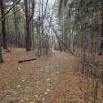 Click here for more information or to register Hosting Club: Caledon Hills, Peninsula
Category: Nature Walks
Location (Google Maps): The Beer Store, 875 Highland Rd. W, Kitchener, ON. What3Words: dozen.takover.says Hike Leader(s): Daniel J Patterson Click here to contact Hike Leader(s) Pace: Medium – 3 to 4 km/hour
Terrain: Easy – mostly flat and usually good footing
Distance: 10 km Description
Interested in hiking the Bruce Trail? Looking for a place to start? How about checking out Wednesday Waterloo Wayfarers? We will explore the urban, suburban and rural trails in the Waterloo Region including parts of the Avon, Guelph to Goderich, and Grand River trails. Speed: 3-3.5 km/hr. Distance 8-12 km. Most will be fairly flat, but some will involve hills. Bring at least 1 liter of water, sturdy hiking boots, snacks and a positive attitude! And hiking poles if you like.
| 7 - Seven Rivers Series – Hike 2 of 7
9:15 AM-2:00 PM 05/07/2026 https://hikes.brucetrail.org/event/seven-rivers-series-hike-2-of-7/2026-05-07/ Click here for more information or to register Hosting Club: Caledon Hills
Category: General
Location (Google Maps): Boyne River – Dufferin Hi-Land Section.
Meet at the parking lot south of 5 Sideroad, at the end of Centre Road. (km 17.6) Hike Leader(s): Nancy Mooney Click here to contact Hike Leader(s) Pace: Medium – 3 to 4 km/hour
Terrain: Moderate – some hills and/or some poor footing, Strenuous – hilly with steep climbs and some poor footing
Distance: 13.3 km Description
This is the second hike of the series and will take us through Boyne Valley Provincial Park including Mulmur Lookout and Murphy’s Pinnacle.
| 8 | 9  Loop Hike Hockley Rd 5th Line EHS to 3rd Line EHS Loop Hike Hockley Rd 5th Line EHS to 3rd Line EHS 8:30 AM-12:15 PM 05/09/2026 https://hikes.brucetrail.org/event/car-hike-loop-hike-hockley-rd-5th-ehs-to-3rd-ehs/2026-05-09/  Click here for more information or to register Hosting Club: Toronto, Caledon Hills
Category: Car Hike
Location (Google Maps): Bruce Trail parking lot on the east side of 5th Line EHS, just south of Hockley Rd. (873603 5 EHS LINE, Mono, ON L9W 6N3) Hike Leader(s): Amir Alemohammad Pace: Moderate (3-4 km/hr)
Terrain: Hilly, Level 2 (Intermediate – some hills and uneven surfaces, rocks and roots underfoot), Variable
Distance (km): 12-14 Description
Join us for a loop hike along the trails of the Hockley Rd region, one of the most beautiful hiking areas in Caledon. Known for its rolling hills, forested trails, and ever-changing seasonal scenery, this hike takes you through a mixed hardwood forest, providing ample shade—perfect for this time of year. You’ll also encounter moderate elevation changes, with some sections following ridge lines and valleys that offer occasional breathtaking scenic viewpoints. We will hike main and side trails between 5th and 3rd Line EHS. Boots mandatory, poles recommended, bring two litres of water, your snack and dress according to weather conditions.
|
10 - Sydenham
8:30 AM-2:30 PM 05/10/2026 https://hikes.brucetrail.org/event/sydenham/2026-05-10/ 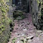 Click here for more information or to register Hosting Club: Caledon Hills, Blue Mountains
Category: General
Location (Google Maps): Meet at Irish Block Line parking north of HWY 26. We will shuttle to Pioneer Tower, HWY 6 at Owen Sound and hike back. Hike Leader(s): Dan Patterson Click here to contact Hike Leader(s) Pace: Medium – 3 to 4 km/hour
Terrain: Moderate – some hills and/or some poor footing
Distance: 18.9 km Description
Sydenham has many hidden gems. This section features amazing crevices. Come prepared for an adventure! Bring sufficient water, lunch, snacks, bug repellent and a smile! We will meet at Irish Block Line and shuttle to Pioneer Tower on HWY 6 at Owen Sound. This is the first of 3 Sydenham Section hikes I am leading. If you are working on the Sydenham section these hikes may help you. I can also provide a plan for the rest of the section. The other hikes are Saturday June 13 and Saturdy June 27. These cover the last 2 stages into Wiarton.
| 11 - *Caledon Hills Sideways Badge – Hike #3
9:00 AM-3:00 PM 05/11/2026 https://hikes.brucetrail.org/event/caledon-hills-sideways-badge-hike-3/2026-05-11/ 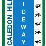 Click here for more information or to register Hosting Club: Iroquoia, Caledon Hills
Category: Special Event
Location (Google Maps): Caledon Hills – Location will be advised Hike Leader(s): Heather Zrini Click here to contact Hike Leader(s) Pace: Medium – 3 to 4 km/hr
Terrain: Dependent on Conditions, Moderate – Some hills and/or some poor footing, Strenuous – Hilly with steep climbs and some poor footing
Distance: 20 km Description
On this series of three hiking days, we will complete the five loop hikes that are required to earn the Caledon Hills Sideways Badge. If you are not interested in earning the badge, please join us for some great hiking. Hikers can sign up for individual hikes as you do not need to complete all three to participate. The dates of the three hiking days will be April 13, April 27 and May 11. We will meet at the starting point at 9am each week. Our finishing time is an approximation. On each of the first two hiking days, we will be completing two of the loops. On May 11, there will be one loop hike and if there is interest, we will hike another loop in Mono Cliffs Provincial Park. Each loop is approximately 10 km in length. For more information about the hikes, please see the link below: Sideways Badge Loop .PDF Download Our schedule will be as follows: April 13 – Hike One and Hike Five April 27 – Hike Two and Hike Three May 11 – Hike Four and a hike in Mono Cliffs Provincial Park Carpooling is encouraged. Since these are loop hikes, we will not need to shuttle. On the first day, a Provincial Park Daily Vehicle Permit Reservation will be required. We will be parking and hiking in the Forks of the Credit Provincial Park on Day 1. Passes that can be used when making the reservation can be purchased through the Ontario Provincial Park website or borrowed from your local library. If a car does not have a pass, the cost of the Daily Vehicle Permit reservation will be split between those people in that car. More information, including specific details about the meeting points, will be provided to those who sign up for the hikes. If there are any questions, please don’t hesitate to ask.
- Seven Rivers Series – Hike 3 of 7
9:15 AM-2:00 PM 05/11/2026 https://hikes.brucetrail.org/event/seven-rivers-series-hike-3-of-7/2026-05-11/ Click here for more information or to register Hosting Club: Caledon Hills
Category: General
Location (Google Maps): Pine River – Dufferin Hi-Land Section.
Meet at Whitfield Church parking, km 30.4 located 40 metres north of 10 Sideroad, at Centre Road and 10 Sideroad. (County Road 17) Hike Leader(s): Nancy Mooney Click here to contact Hike Leader(s) Pace: Medium – 3 to 4 km/hour
Terrain: Moderate – some hills and/or some poor footing, Strenuous – hilly with steep climbs and some poor footing
Distance: 13 km Description
This is the third hike in the series and will explore the trails around the Pine River including the Bell Lookout and the Pine River Side Trail.
| 12 - Hiking Lavender to Black Bank, Dufferin Hi-Land Section
9:45 AM-1:45 AM 05/12/2026 https://hikes.brucetrail.org/event/hiking-lavender-to-black-bank-dufferin-hi-land-section/2026-05-12/ Hike open to BTC Members only. Click here for more information or to register Hosting Club: Caledon Hills
Category: Tuesday Hikers
Location (Google Maps): Dufferin Hi-Land Section Lavender. Park in the Bruce Trail Parking lot, corner of 1st Line EHS and 30 Sideroad. Hike Leader(s): Doris Harper Click here to contact Hike Leader(s) Pace: Medium – 3 to 4 km/hour
Terrain: Moderate – some hills and/or some poor footing
Distance: approximately 10 km Description
Meet 9:45 AM in the Bruce Trail Parking lot on 1st Line EHS and 30 Sideroad. From the parking lot we will shuttle to Prince of Wales Rd., km 44.7, and hike back to our cars. About 10 km.The trail crosses creeks and there are some steep climbs but great scenery at the top. Bring water, snacks, dress for the weather. First Aid kit and poles recommended. Please reply all only if you plan to hike. Invite a friend if you like.
| 13 | 14 - Seven Rivers Series – Hike 4 of 7
9:15 AM-2:00 PM 05/14/2026 https://hikes.brucetrail.org/event/seven-rivers-series-hike-4-of-7/2026-05-14/ Click here for more information or to register Hosting Club: Caledon Hills
Category: General
Location (Google Maps): Noisy River – Blue Mountains Section.
Meet at roadside parking south side of County Road 9 at km 6.1 Hike Leader(s): Nancy Mooney Click here to contact Hike Leader(s) Pace: Medium – 3 to 4 km/hour
Terrain: Moderate – some hills and/or some poor footing
Distance: 13.4 km Description
This is the fourth hike in the series and will take us through the Noisy River Provincial Nature Reserve.
| 15 - Car Hike: Fitness hike in the Hockley Valley (spring flowers hike)
10:30 AM-3:30 PM 05/15/2026 https://hikes.brucetrail.org/event/car-hike-midweek-fitness-hike-in-the-hockley-valley-spring-flowers-hike-2/2026-05-15/ Click here for more information or to register Hosting Club: Toronto, Caledon Hills
Category: Car Hike
Location (Google Maps): Hockley Valley Provincial Nature Reserve Hike Leader(s): Natalia Svechnikova Click here to contact Hike Leader(s) Pace: Moderate (3-4 km/hr) Distance (km): about 14 km Description
Please join me for an enjoyable spring flowers hike on the Bruce Trail (main and side trails). We will be following a loop of ca 14 km and try to keep a moderate pace of about 3 km/h. The trail is a bit hilly with a few uphill sections after which we will stop for short water breaks. There will be a lunch break for about 20 min. We should be back to the parking lot around 3:30 pm. Please be dressed for the weather, wear hiking shoes/boots and pack your rain gear (just in case), at least 2 L of water, light lunch and snacks, your sunglasses and/or hut. We will meet on the dedicated Hockley Valley PNR / Bruce Trail parking lot on the Hockley Road (opposit side of the Hockley Valley Resort and the Black Birch Restaurant (exact map location 43.9728974807774, -80.05570691699788) just before 10:30 am and start hiking at 10:30 am. Please note that this hike will be cancelled in case of inclement weather.
| 16 - Beaver Valley Blantyre
8:30 AM-2:00 PM 05/16/2026 https://hikes.brucetrail.org/event/beaver-valley-blantyre/2026-05-16/  Click here for more information or to register Hosting Club: Caledon Hills
Category: General
Location (Google Maps): We will meet at Blantyre, and then shuttle to Side Road 22 C & 3rd Line C, 99.9 km point on BT Reference Guide Edition 31, and hike to the end of the Beaver Valley section. Hike Leader(s): Dan Patterson Click here to contact Hike Leader(s) Pace: Brisk – 4 to 5 km/hour, Medium – 3 to 4 km/hour
Terrain: Moderate – some hills and/or some poor footing
Distance: 17.9 km Description
Bring sufficient water, lunch, snacks, bug repellent and great attitude! Hiking poles are useful in this area.
- Car Hike: Scotsdale Farm
9:00 AM-2:30 PM 05/16/2026 https://hikes.brucetrail.org/event/car-hike-scotsdale-farm-20/2026-05-16/ Click here for more information or to register Hosting Club: Caledon Hills
Category: General
Location (Google Maps): Scotsdale Farm, Map 13. Directions; from Highway 401, head north on Trafalgar Road past Georgetown. Trafalgar briefly merges with Highway 7 for about 3 km before separating to the right at the village of Silver Creek. At the stop light in Silver Creek, continue north on Trafalgar Road for about 1 km to the entrance of Scotsdale Farm on your right. Drive in about half a kilometre to reach the parking area. Hike Leader(s): Lana Hubbard Click here to contact Hike Leader(s) Pace: Medium – 3 to 4 km/hour
Terrain: Moderate – some hills and/or some poor footing
Distance: 12 km Description
Join us for a loop hike along the main Bruce Trail and its scenic side trails, including the stunning Great Esker Side Trail. Please dress appropriately for the weather, bring plenty of water, and pack some snacks. Note that parts of the trail are rocky, so poles are highly recommended. We are committed to fostering an inclusive and welcoming environment. This hike is an LGBTQ+ safe space, and everyone is encouraged to join us!
- Saturday Shorts
10:00 AM-12:00 PM 05/16/2026 https://hikes.brucetrail.org/event/saturday-shorts-4/2026-05-16/ Click here for more information or to register Hosting Club: Caledon Hills
Category: Nature Walks
Location (Google Maps): BTC Reference Guide, Map 12. Meet at parking lot on the south side of 22nd Sideroad, across from the school, and north of km 21.6. Hike Leader(s): Janice McClelland Click here to contact Hike Leader(s) Pace: Leisurely – 3 km/hour or less
Terrain: Moderate – some hills and/or some poor footing
Distance: 5.8 km Description
We will hike north on the main Bruce Trail, quietly follow the Ridge Side Trail, include the Ancient Maple Side Trail, returning via main Trail, pausing south of the village of LImehouse on the bridge to take in the tumbling waters of Black Creek and the stones that speak of Limehouse’s industrial history. Then return to our departure spot. Please bring water, a snack and inquisitiveness re the emerging wildflowers & life-renewing trees!
|
17 - Caledon Hills E2E in 4 – Hike #1
8:45 AM-3:30 PM 05/17/2026 https://hikes.brucetrail.org/event/caledon-hills-e2e-in-4-hike-1/2026-05-17/  This is a Multi-Day HikeYou are signing up for the following dates and times:
2026-05-17 at 08:45 Click here for more information or to register Hosting Club: Caledon Hills
Category: End-to-End
Location (Google Maps): Meet at Mono Community Centre, 754463 Mono Centre Rd., Mono, ON L9W 5W9, Canada Hike Leader(s): Dan Patterson Click here to contact Hike Leader(s) Pace: Medium – 3 to 4 km/hour
Terrain: Strenuous – hilly with steep climbs and some poor footing
Distance: 20.94 km Description
Meet at Mono Community Center at 8:45 a.m. Look for tennis courts and park in the gravel parking lot. We will shuttle to 5th Line/Hockley Road parking lot at 9:00 a.m. This is an End-to-End hike series to complete the Caledon section of the Bruce Trail in 4 hikes. We will be hiking from the north end to the south end. Join for all or as many hikes as desired – you will need to register for each hike in the series which will take place on the following dates: May 17, 24, June 7, 21. Since this is a group hike, please consider your fitness level before registering. We will be walking at a pace of 3 km – 4 km per hour and hikers will need to keep up with the person in front of them for the duration of the hike. The hike series will also involve car shuttles and every hiker is expected to participate as drivers. Weather conditions can be variable, dressing in layers is recommended. Hiking boots are required and hiking poles are strongly recommended. Bring plenty of fluids, electrolytes and a snack. This section is challenging with many hills.
| 18 - Car HIke: Dog-Friendly Caledon side trail hikes
8:45 AM-3:00 PM 05/18/2026 https://hikes.brucetrail.org/event/car-hike-dog-friendly-caledon-side-trail-hikes/2026-05-18/ Click here for more information or to register Hosting Club: Toronto, Caledon Hills
Category: Car Hike
Location (Google Maps): Hockley Valley South Hike Leader(s): Lindita Kalo Click here to contact Hike Leader(s) Pace: Mixed (See Hike Description), Moderate (3-4 km/hr)
Terrain: Challenging, Level 3 (Advanced – steep hills and some scrambling over boulders), Variable
Distance (km): 20km, Optional dropout at 10km Description
Join me on the series of dog friendly to complete Caledon side trail challenge. You have the option to hike 10km, or 20km. Both hikes Hockley Valley main Bruce trail and side trail.
Those hikes have some hills. We will keep moderate speed. For those joining both hikes be true to your abilities of hiking long distance.
| 19 | 20 - Waterloo Region Wednesday Wayfairers
8:45 AM-12:00 PM 05/20/2026 https://hikes.brucetrail.org/event/waterloo-region-wednesday-wayfairers/2026-05-20/ 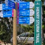 Click here for more information or to register Hosting Club: Caledon Hills
Category: General
Location (Google Maps): Meet at The Beer Store, 875 Highland Rd. W., (Highland Rd. and Fischer-Hallman Rd.) Hike Leader(s): Dan Patterson Click here to contact Hike Leader(s) Pace: Medium – 3 to 4 km/hour
Terrain: Easy – mostly flat and usually good footing
Distance: 10 km Description
Meet at 8:45 a.m. and walk on the Henry Strum Trail connecting with the Hearth Green Trail to Lakeshore Park, then take the Conestoga Parkway overpass to Strasburg & Ottawa Streets for coffee. We will return on the same route back to the cars. Study boots, sufficient water, snacks and a good attitude are required. Poles are optional. This is a very flat trail.
| 21 - Seven Rivers Series – Hike 5 of 7
9:15 AM-2:00 PM 05/21/2026 https://hikes.brucetrail.org/event/seven-rivers-series-hike-5-of-7/2026-05-21/ Click here for more information or to register Hosting Club: Caledon Hills
Category: General
Location (Google Maps): Mad River – Blue Mountains Section.
Meet at Devil’s Glen parking lot off County Road 124, km 29.5. Hike Leader(s): Nancy Mooney Click here to contact Hike Leader(s) Pace: Medium – 3 to 4 km/hour
Terrain: Moderate – some hills and/or some poor footing, Strenuous – hilly with steep climbs and some poor footing
Distance: 11 km Description
This is the fifth hike of the series and will take us along the Mad River including the Devil’s Glen viewing platform.
| 22 | 23 - Car Hike: Hockley Crest, Airport Rd to Hockley Rd
8:30 AM-12:00 PM 05/23/2026 https://hikes.brucetrail.org/event/car-hike-hockley-crest-airport-rd-to-hockley-rd/2026-05-23/ Click here for more information or to register Hosting Club: Toronto, Caledon Hills
Category: Cancelled
Location (Google Maps): Meet at the Bruce Trail Parking Lot on Mono 5 Sideroad on the north side of the 5th Sideroad. Hike Leader(s): Amir Alemohammad Click here to contact Hike Leader(s) Pace: Moderate (3-4 km/hr)
Terrain: Flat, Hilly, Level 2 (Intermediate – some hills and uneven surfaces, rocks and roots underfoot), Variable
Distance (km): 12-14 km Description
Join us for a out and back hike in Hockley Crest. The route explores a diverse landscape of dense sugar maple and beech hardwood forests, open grassy meadows, active pine plantations, and steep ravines. We will explore the main and side trails of the Bruce Trail. Bring at least two liters of water and your favorite snacks. Boots mandatory, poles recommended. Be prepared for the ticks and bugs. This is a joint hike with the ORTA.
- Habitat Restoration Planting at Riverside Woods
10:30 AM-12:30 PM 05/23/2026 https://hikes.brucetrail.org/event/habitat-restoration-planting-at-riverside-woods/2026-05-23/ Click here for more information or to register Hosting Club: Caledon Hills
Category: Habitat Restoration Project
Location (Google Maps): Akela & Scouters Heather and Ross Hamlin Nature Reserve at Riverside Woods Hike Leader(s): Sandra Green Click here to contact Hike Leader(s) Pace: Leisurely – 3 km/hour or less
Terrain: Easy – mostly flat and usually good footing
Distance: Less than 1 km Description
This is a family friendly event. Volunteers will help restore the habitat for the Red Headed Woodpecker! Come join the CHBTC Biodiversity Team as we add to the biodiversity of our Riverside Woods property. We will be installing a variety of trees and shrubs in an area that was previously infested with Japanese Knotweed. The event will begin at 10:30 a.m. out of the main parking lot at Riverside Woods. We will hike down to the planting location and discuss the work that has been undertaken by BTC Staff and CHBTC Volunteers to remove invasive species along the way. Participants are asked to wear pants and sturdy footwear. Please bring water for drinking, as well as gardening or work gloves. Shovels and extra gloves will be provided.
|
24 - Caledon Hills E2E in 4 – Hike #2
8:30 AM-3:00 PM 05/24/2026 https://hikes.brucetrail.org/event/caledon-hills-e2e-in-4-hike-2/2026-05-24/  This is a Multi-Day HikeYou are signing up for the following dates and times:
2026-05-24 at 08:30 Click here for more information or to register Hosting Club: Caledon Hills
Category: End-to-End
Location (Google Maps): Roadside parking on Coolihans Sideroad, east of where the trail crosses the road – km 35.0
6485 Coolihans Side Rd, Caledon, ON L7K 0P8, Canada Hike Leader(s): Dan Patterson Click here to contact Hike Leader(s) Pace: Medium – 3 to 4 km/hour
Terrain: Moderate – some hills and/or some poor footing
Distance: 16.3 km Description
We will meet at Coolihans Side Road at 8:30 a.m. and shuttle to 5th Line EHS parking at Hockley Road at 9:00 sharp. This is an End-to-End hike series to complete the Caledon section of the Bruce Trail in 4 hikes. We will be hiking from the north end to the south end. Join for all or as many hikes as desired – you will need to register for each hike in the series which will take place on the following dates: May 17, 24, June 7, 21 Since this is a group hike, please consider your fitness level before registering. We will be walking at a pace of 3 km – 4 km per hour and hikers will need to keep up with the person in front of them for the duration of the hike. The hike series will also involve car shuttles and every hiker is expected to participate as drivers. Weather conditions can be variable, dressing in layers is recommended. Hiking boots are required and hiking poles are strongly recommended. Bring plenty of fluids, electrolytes and a snack. This section is challenging with many hills.
| 25 - Seven Rivers Series – Hike 6 of 7
9:15 AM-2:00 PM 05/25/2026 https://hikes.brucetrail.org/event/seven-rivers-series-hike-6-of-7/2026-05-25/ Click here for more information or to register Hosting Club: Caledon Hills
Category: General
Location (Google Maps): Pretty River – Blue Mountains Section.
Meet at the parking lot on Pretty River Road north of km 46.8. Hike Leader(s): Nancy Mooney Click here to contact Hike Leader(s) Pace: Medium – 3 to 4 km/hour
Terrain: Moderate – some hills and/or some poor footing, Strenuous – hilly with steep climbs and some poor footing
Distance: 12 km Description
This is the sixth hike in the series and goes through Pretty River Valley Provincial Park including the Highest Point on the Bruce Trail.
| 26 - Habitat Restoration Project – Controlling the Spread of Garlic Mustard
9:00 AM-11:00 AM 05/26/2026 https://hikes.brucetrail.org/event/habitat-restoration-project-controlling-the-spread-of-garlic-mustard-2/2026-05-26/  Click here for more information or to register Hosting Club: Caledon Hills
Category: Habitat Restoration Project
Location (Google Maps): Meet at the parking lot on the east side of 3rd Line EHS, 43.992646, -80.047917. Directions: From ON-10 head east on Hockley Rd./Dufferin County Rd. 7 for 6.5 km. Turn left onto 3rd Line EHS and drive for 1.0 km. Parking is on the right. Hike Leader(s): Sandy Green Click here to contact Hike Leader(s) Pace: Leisurely – 3 km/hour or less
Terrain: Moderate – some hills and/or some poor footing
Distance: 2 kilometres Description
Volunteers are needed to help control the spread of garlic mustard at the Hockley Valley Provincial Nature Reserve. Join Ron and Sandy to pull the invasive species by hand or if you prefer, bring a small trowel or dandelion weeder. Wear long sleeves and long pants. Pack gloves, sunscreen, insect repellent, a beverage, and a snack. The work is satisfying, and the camaraderie is always fun. All are welcome to help enhance biodiversity.
| 27 - Habitat Restoration Project – Controlling the Spread of Garlic Mustard
12:00 PM-3:00 PM 05/27/2026 https://hikes.brucetrail.org/event/habitat-restoration-project-controlling-the-spread-of-garlic-mustard-3/2026-05-27/  Click here for more information or to register Hosting Club: Caledon Hills
Category: Habitat Restoration Project
Location (Google Maps): Meet at Hockley Valley Provincial Nature Reserve Parking Lot on Hockley Road, 43.972857, -80.056330. Directions: From ON-10 turn east onto Hockley Rd./Dufferin County Rd. 7. Drive for 5.1 kilometres. Hike Leader(s): Sandy Green Click here to contact Hike Leader(s) Pace: Leisurely – 3 km/hour or less
Terrain: Moderate – some hills and/or some poor footing
Distance: 2 kilometres Description
Volunteers are needed to help control the spread of garlic mustard at the Hockley Valley Provincial Nature Reserve. Join Ron and Sandy to pull the invasive species by hand or if you prefer, bring a small trowel or dandelion weeder. Wear long sleeves and long pants. Pack gloves, sunscreen, insect repellent, a beverage, and a snack. The work is satisfying, and the camaraderie is always fun. All are welcome to help enhance biodiversity.
| 28 - Seven Rivers Series – Hike 7 of 7
9:15 AM-2:00 PM 05/28/2026 https://hikes.brucetrail.org/event/seven-rivers-series-hike-7-of-7/2026-05-28/ Click here for more information or to register Hosting Club: Caledon Hills
Category: General
Location (Google Maps): Humber River – Caledon hills Section.
Meet at the parking on Mono 5 Sideroad. Hike Leader(s): Nancy Mooney Click here to contact Hike Leader(s) Pace: Medium – 3 to 4 km/hour
Terrain: Moderate – some hills and/or some poor footing, Strenuous – hilly with steep climbs and some poor footing
Distance: 12 km Description
This is the last hike in the series and takes us through the Humber Valley. Yay, another badge earned!
| 29 - Car Hike: Fitness Hike in the Forks of the Credit Provincial Park (ca 10 km) Apple Trees Blossom
10:30 AM-2:30 PM 05/29/2026 https://hikes.brucetrail.org/event/car-hike-midweek-fitness-hike-in-the-forks-of-the-credit-provincial-park-ca-10-km-apple-trees-blossom-2/2026-05-29/ Click here for more information or to register Hosting Club: Toronto, Caledon Hills
Category: Car Hike
Location (Google Maps): Forks of the Credit Provincial Park (McLaren Road entrance) Hike Leader(s): Natalia Svechnikova Click here to contact Hike Leader(s) Pace: Moderate (3-4 km/hr)
Terrain: Level 2 (Intermediate – some hills and uneven surfaces, rocks and roots underfoot)
Distance (km): 10 km Description
Please join me for an enjoyable fitness hike on a hilly part of the park and, hopefully with views of apple tress blossom. We will hike a 10 km loop with one section going up hill. The trail has mostly treed sections as well as a few open areas. There will be a lunch stop near the Credit River. Be prepared wearing comfortable cloths, hiking shoes/boots. Please bring at least 2 L of water, a light lunch/snacks, sun screen and bug spray optional. We will on the parking lot at the trail head and map poster to the right of the washroom facilities. You have to drive to the main entrance on the McLaren Road and pay for the parking. This car hike will be cancelled if the there is a heavy rain, storm etc in the forecast.
| 30 - Car Hike: Hockley Crest, Airport Rd to Hockley Rd
8:30 AM-12:00 PM 05/30/2026 https://hikes.brucetrail.org/event/car-hike-hockley-crest-airport-rd-to-hockley-rd-2/2026-05-30/ Click here for more information or to register Hosting Club: Toronto, Caledon Hills
Category: Car Hike
Location (Google Maps): Meet at the Bruce Trail Parking Lot on Mono 5 Sideroad on the north side of the 5th Sideroad. Hike Leader(s): Amir Alemohammad Click here to contact Hike Leader(s) Pace: Moderate (3-4 km/hr)
Terrain: Flat, Hilly, Level 2 (Intermediate – some hills and uneven surfaces, rocks and roots underfoot), Variable
Distance (km): 12-14 km Description
Join us for a out and back hike in Hockley Crest. The route explores a diverse landscape of dense sugar maple and beech hardwood forests, open grassy meadows, active pine plantations, and steep ravines. We will explore the main and side trails of the Bruce Trail. Bring at least two liters of water and your favorite snacks. Boots mandatory, poles recommended. Be prepared for the ticks and bugs. This is a joint hike with the ORTA.
- Escarpment Sideroad Trail Reroute
9:00 AM-12:30 PM 05/30/2026 https://hikes.brucetrail.org/event/escarpment-sideroad-trail-reroute/2026-05-30/ Click here for more information or to register Hosting Club: Caledon Hills
Category: Trail Development Project
Location (Google Maps): Just west of Highway 10 at the corner of Escarpment Side road and Willoughby Road Hike Leader(s): Lynn Dobson Click here to contact Hike Leader(s) Terrain: Strenuous – hilly with steep climbs and some poor footing Description
The work to be done will be moving materials to a variety of work sites to build boardwalks and bridges. There will also be some benching along a steep slope to make an easier hiking trail. If all goes well the team can also blaze the new trail on the same day.
- Habitat Restoration Project – Controlling the Spread of Garlic Mustard
1:00 PM-3:30 PM 05/30/2026 https://hikes.brucetrail.org/event/habitat-restoration-project-controlling-the-spread-of-garlic-mustard/2026-05-30/ 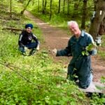 Click here for more information or to register Hosting Club: Caledon Hills
Category: Habitat Restoration Project
Location (Google Maps): Meet at Mono 5 Sideroad Parking lot east of Airport Road 43.974055 – 79.984988 From Airport Road, head east on Mono 5 Sideroad for approximately 1 kilometre. The parking lot is on the left side. Hike Leader(s): Sandy Green Click here to contact Hike Leader(s) Pace: Leisurely – 3 km/hour or less
Terrain: Easy – mostly flat and usually good footing
Distance: 2 kilometres Description
Volunteers are needed to help control the spread of garlic mustard on two BTC Protected Natural Areas in the Hockley Valley East area. Join Land Stewards Bill and Sandy to pull the invasive species by hand or if you prefer bring a small trowel or dandelion weeder. Wear long sleeves and long pants. Pack gloves, sunscreen, insect repellent, a beverage, and a snack. The work is satisfying, and the camaraderie is always fun. All are welcome to help enhance biodiversity.
|
31  Yoga + Hike Fundraiser Yoga + Hike Fundraiser 9:30 AM-12:45 PM 05/31/2026 https://hikes.brucetrail.org/event/yoga-hike-fundraiser-2/2026-05-31/  Click here for more information or to register Hosting Club: Caledon Hills
Category: General
Location (Google Maps): Meet at the BTC parking lot, 713377 1st Line EHS, Mono. It is easier to go north on 1st Line from Side Road 5 than it is to go south on 1st Line from Hockley Road. 1st Line is not maintained between the parking lot and Hockley Road. It is best to aim for arriving around 9:15 am, so we can start our yoga session as close to 9:30 as possible. Thanks! Hike Leader(s): Elizabeth Ganong and Janice McLelland Click here to contact Hike Leader(s) Pace: Leisurely – 3 km/hour or less
Terrain: Easy – mostly flat and usually good footing, Moderate – some hills and/or some poor footing
Distance: Approximately 4 km Description
Join us for the CHBTC’s Yoga + Hike Fundraiser happening at Riverside Woods. Led by Elaine Vallevand, we’ll start with an outdoor yoga session at 9:30 am. Bring your mat! Light refreshments will be provided following our yoga session. During this break, you will have time to put your mat in your vehicle and get ready to hike. By 11 am, we should be on the trails. The large group will be divided into two smaller groups to enable hikers to better enjoy our forest bathing inspired hike, approximately 4 km. The Marsh Marigolds are in bloom! Plan to be finished just after 12:30 pm. 100% of the proceeds will support maintaining and preserving the Bruce Trail. Our kind and giving yoga instructor is donating her time, the refreshments are donated by our generous organizing team, and of course, our hike leaders are donating their time. Thank you for your generosity in being part of this event! There is no separate program for participating children, but all those who aspire to connect with nature in a meaningful way are welcome. While there are no refunds for this fundraiser, you may name a person who will take your spot. Please message the hike leaders to name the person attending in your place. Thanks! Things to consider bringing: a water bottle, a mat, a blanket (if you want a larger area on the grass covered), insect repellent, sunscreen, a hat, hiking shoes/boots, poles, a snack/lunch.
| June | June | June | June | June | June |