|
Sun | Mon | Tue | Wed | Thu | Fri | Sat |
|---|
1 | 2 | 3  Sydenham E2E (includes small parts of South Peninsula & North Beaver Valley) Sydenham E2E (includes small parts of South Peninsula & North Beaver Valley) 7:30 AM-2:00 PM 09/03/2024 https://hikes.brucetrail.org/event/sydenham-e2e-includes-small-parts-of-south-peninsula-north-beaver-valley/2024-09-03/ Hike open to BTC Members only. This is a Multi-Day HikeYou are signing up for the following dates and times:
2024-09-03 at 07:30
2024-09-04 at 07:30
2024-09-16 at 07:30
2024-09-17 at 07:30
2024-09-18 at 07:30
2024-09-23 at 07:30
2024-09-24 at 07:30
2024-09-25 at 07:30
2024-10-10 at 07:30 Click here for more information or to register Hosting Club: Iroquoia, Caledon Hills, Sydenham
Category: End-to-End
Location (Google Maps): Bruce’s Caves parking lot – fee by Conservation Authority; capacity: 10 Hike Leader(s): Heather Murch Click here to contact Hike Leader(s) Pace: Brisk – 4 to 5 km/hour
Terrain: Moderate – some hills and/or some poor footing
Distance: 21.1 km Description
Hikes are co-led by Heather Murch (Caledon Hills) & Steven White (Iroquoia) This is an opportunity to achieve a Sydenham E2E, donate to the Bruce Trail and earn a beautiful ‘stained glass’ badge. We are a group of friends who are hiking Cairn to Cairn starting after Labour Day and finishing before Christmas. We’ve decided this year to hike right through Club Boundaries. It helps us to maintain a more consistent number of km’s for each hike and it reduces the complexity of having to end at a certain spot (Club Boundary); which quite often don’t have parking right there. So, the schedule is a bit odd; but you are welcome to join us for the Sydenham section. We will generally be starting 10.7km in from the north end of Sydenham finishing those km’s a few weeks later as part of a hike through the trail-south boundary of the Peninsula Club (Wiarton). Study the calendar carefully as you won’t see an obvious pattern to the dates selected. 3-Sep-24
Sydenham
21.1 km 4-Sep-24
Sydenham
23.7 16-Sep-24
Sydenham
20.6 17-Sep-24
Sydenham
25.8 18-Sep-24
Sydenham
19.8 23-Sep-24
Sydenham
20.9 24-Sep-24
Sydenham
24.4 25-Sep-24
Sydenham
24.8 25-Sep-24
Beaver Valley
17.4 10-Oct-24
South Peninsula
12.9 10-Oct-24
North Sydenham
10.7
- Terra Cotta
9:30 AM-2:00 PM 09/03/2024 https://hikes.brucetrail.org/event/terra-cotta-13/2024-09-03/ Click here for more information or to register Hosting Club: Caledon Hills
Category: Tuesday Hikers
Location (Google Maps): Meet at Winston Churchill Blvd., intersection with Caledon Trailway.
Driving direction: North on Highway 410, continue north on Highway 10, left on King Street, right on Winston Churchill Blvd; drive 1 kilometre to roadside parking close to Caledon Trailway. Hike Leader(s): Mohammad Shafiq Click here to contact Hike Leader(s) Pace: Medium – 3 to 4 km/hour
Terrain: Moderate – some hills and/or some poor footing
Distance: 12 km Description
Will hike Terra Cotta Side Trail and main Bruce Trail. Bring water, snack, poles and bug spray.
Hike Leaders phone contact for the day of hike: 416-566-0503.
| 4 | 5 - Niagara End-to-End Hike 1 of 6
9:30 AM-2:30 PM 09/05/2024 https://hikes.brucetrail.org/event/niagara-end-to-end-hike-1-of-6/2024-09-05/ Click here for more information or to register Hosting Club: Caledon Hills
Category: End-to-End
Location (Google Maps): Meet at 9:30 am at Kinsmen Park, km 68.5 (Map 4). Shuttle to start at Grimsby Lions Community Pool. Hike Leader(s): Nancy Mooney Click here to contact Hike Leader(s) Pace: Medium – 3 to 4 km/hour
Terrain: Moderate – some hills and/or some poor footing, Strenuous – hilly with steep climbs and some poor footing
Distance: 81.7 – 68.5 + trail to parking = 13.5 km total Description
This is the first hike of the series going from the north to the south. The trail will take us past the Mike Weir Estate Winery, Thirty Mile Creek and waterfall, and views of Beamsville Bench vineyard.
| 6 | 7 - Saturday Shorts: Hockley
9:00 AM-10:30 AM 09/07/2024 https://hikes.brucetrail.org/event/saturday-shorts-2/2024-09-07/  Hike open to BTC Members only. Click here for more information or to register Hosting Club: Caledon Hills
Category: General
Location (Google Maps): Meet at 9 am at the Parking Area, east of km 65.3, on 3rd Line, north of Hockley Road (10 cars). (Note: We are not meeting at the main parking area on Hockley Road. Go north on 3rd Line. The parking area is on the east side of the road.) Hike Leader(s): Elizabeth Ganong Click here to contact Hike Leader(s) Pace: Medium – 3 to 4 km/hour
Terrain: Moderate – some hills and/or some poor footing, Strenuous – hilly with steep climbs and some poor footing
Distance: 4 km Description
Looking to get out on a Saturday but not give up your whole day? Saturday Shorts, a hiking series, will get you out in a small group on a short hike. This Saturday’s hike is a hilly challenge as we use side trails and the main trail to make a 4 km loop in the Hockley Valley Provincial Nature Reserve. Bring water and a snack, if desired. There will be a short break. No dogs please.
|
8 | 9 - 60th Anniversary Vintage Badge End-to-End
8:00 AM-4:00 PM 09/09/2024 https://hikes.brucetrail.org/event/60th-anniversary-vintage-badge-end-to-end/2024-09-09/  This is a Multi-Day HikeYou are signing up for the following dates:
2024-09-09, 2024-09-10, 2024-09-11 Click here for more information or to register Hosting Club: Caledon Hills
Category: End-to-End
Location (Google Maps): Meet at km 45.4, parking lot on Mono 5 Sideroad on the north side of the road, 43.974055, -79.984988. Directions: From Airport Road turn east onto 5 Sideroad and drive for 600 metres. The parking lot is on the left hand side. Shuttle to Mono Community Centre, 200 metres south of Mono Centre (County Road 8), 44.026195, -80.071516. Hike Leader(s): Sandy Green Click here to contact Hike Leader(s) Pace: Brisk – 4 to 5 km/hour
Terrain: Strenuous – hilly with steep climbs and some poor footing
Distance: 27.5 kilometres Description
Earn the CHBTC 60th Anniversary vintage E2E badge in three hikes. Pack sufficient water and snacks to boost your energy. Sturdy footwear is highly recommended. Participants can simultaneously earn the “60 for the 60th” badge as well. Badges will be available for purchase, $10.00 for BTC members and $15.00 for non-members. Hike 1 – Hike from Mono Community Centre south to km 45.4/Mono 5 Sideroad. Distance 27.5. Hike 2 – Hike from km 0.0/Creditview Road north to km 20.8/Escarpment Sideroad and Heartlake Road. Distance 20. 8. Hike 3 – Hike from km 20.8/Escarpment Sideroad and Heartlake Road north to 45.4/Mono 5 Sideroad. Distance 24.6. Note: Participants meet at the end locations and shuttle together to the starting points.
- Hike 1 of 7 – Caledon Hills E2E
9:15 AM-2:00 PM 09/09/2024 https://hikes.brucetrail.org/event/hike-1-of-7-caledon-hills-e2e/2024-09-09/  Click here for more information or to register Hosting Club: Caledon Hills
Category: End-to-End
Location (Google Maps): Meet at 9:15 am at Creditview Rd. and The Grange Side Road.
Shuttle to start at Boston Mills Rd. Hike Leader(s): Jennie Greenfield Click here to contact Hike Leader(s) Pace: Medium – 3 to 4 km/hour
Terrain: Moderate – some hills and/or some poor footing
Distance: 9.65 km Description
Hike 1 of 7 – Caledon Hills E2E. Hike includes the last 3 km of Toronto Section, through the Cheltenham Badlands, then north along a road allowance to the Grange Sideroad. Includes almost 5 km of road walking including 1 km along a busy road. 2.9 of Toronto + 0 to 5.2 of Caledon + 1.45 side trails = 9.55 km total (Edition 31) 6.65 km of this hike can be logged towards the “60 for 60th Anniversary” badge
| 10 | 11 - The World of Butterflies and Dragonflies
9:30 AM-12:00 PM 09/11/2024 https://hikes.brucetrail.org/event/the-world-of-butterflies-and-dragonflies/2024-09-11/  Click here for more information or to register Hosting Club: Caledon Hills
Category: Nature Walks
Location (Google Maps): Riverside Woods Nature Reserve Hike Leader(s): Gary Hall Click here to contact Hike Leader(s) Pace: Leisurely – 3 km/hour or less
Terrain: Easy – mostly flat and usually good footing
Distance: 3 – 4 km Description
Discover the fascinating world of Butterflies, Dragonflies and Damselflies on this leisurely tour of the Riverside Woods Nature Reserve. We’ll try to find as many species as we can and learn all about the various families, their host plants, where they overwinter, etc. Dress for the weather, bring water, snacks, binoculars and camera.
| 12 - Niagara End-to-End Hike 2 of 6
9:30 AM-2:00 PM 09/12/2024 https://hikes.brucetrail.org/event/niagara-end-to-end-hike-2-of-6/2024-09-12/ Click here for more information or to register Hosting Club: Caledon Hills
Category: End-to-End
Location (Google Maps): Meet at parking area north of km 55.5 (Map 4), on the north side of King Rd. Shuttle to start at Kinsmen Park. Hike Leader(s): Nancy Mooney Click here to contact Hike Leader(s) Pace: Medium – 3 to 4 km/hour
Terrain: Moderate – some hills and/or some poor footing, Strenuous – hilly with steep climbs and some poor footing
Distance: 68.5 – 55.5 + 0.5 to parking = 13.5 km total Description
This is the second hike of the series and offers Cave Springs vineyard views, Balls Falls Conservation Area, Twenty Mile Creek valley.
| 13 | 14 - Saturday Shorts: Riverside Woods
9:00 AM-11:00 AM 09/14/2024 https://hikes.brucetrail.org/event/saturday-shorts-riverside-woods/2024-09-14/  Hike open to BTC Members only. Click here for more information or to register Hosting Club: Caledon Hills
Category: General
Location (Google Maps): Meet at 9 am at the BTC parking lot, 713377 1st Line EHS, Mono. It is easier to go north on 1st Line from Side Road 5 than it is to go south on 1st Line from Hockley Road. Hike Leader(s): Elizabeth Ganong Click here to contact Hike Leader(s) Pace: Medium – 3 to 4 km/hour
Terrain: Moderate – some hills and/or some poor footing, Strenuous – hilly with steep climbs and some poor footing
Distance: Approximately 6.5 km Description
Looking to get out on a Saturday but not give up your whole day? Saturday Shorts, a hiking series, will get you out in a small group on a short hike. This Saturday’s hike is another hilly one as we use all side trails to explore Riverside Woods (just south of Hockley Valley Nature Reserve). We’ll hike for about 6.5 km, including walking out to 2nd Line to take a closer look at the heritage house currently owned by the Bruce Trail. Bring water and a snack, if desired. There will be a short break. No dogs please.
|
15 | 16 - Hike 2 of 7 – Caledon Hills E2E
9:15 AM-2:30 PM 09/16/2024 https://hikes.brucetrail.org/event/hike-2-of-7-caledon-hills-e2e/2024-09-16/  Click here for more information or to register Hosting Club: Caledon Hills
Category: End-to-End
Location (Google Maps): Meet at 9:15 at Willoughby Road.
Shuttle to start at Creditview Rd. and the Grange Side Road. Hike Leader(s): Jennie Greenfield Click here to contact Hike Leader(s) Pace: Medium – 3 to 4 km/hour
Terrain: Moderate – some hills and/or some poor footing, Strenuous – hilly with steep climbs and some poor footing
Distance: 12.15 km Description
Hike 2 of 7 for Caledon Hills E2E. Follows recent trail changes around the Forks of the Credit area 5.2 to 15.9 + 1.45 side trails = 12.15 km (Edition 31) This hike can be logged towards the “60 for 60th Anniversary” badge
| 17 - Caledon Hills Section in Six Hikes
9:15 AM-1:30 AM 09/17/2024 https://hikes.brucetrail.org/event/caledon-hills-section-in-six-hikes/2024-09-17/ Hike open to BTC Members only. Click here for more information or to register Hosting Club: Caledon Hills
Category: End-to-End
Location (Google Maps): Meet at 9:15 am at the Hockley Road parking area, km 61.1. Shuttle to start at Mono Centre. Hike Leader(s): Elizabeth Ganong Click here to contact Hike Leader(s) Pace: Medium – 3 to 4 km/hour
Terrain: Moderate – some hills and/or some poor footing, Strenuous – hilly with steep climbs and some poor footing
Distance: 72.4 – 61.1 + 0.750 and 0.250 side trails and road = 12.3 km total Description
This is the first hike in the series going from the north to the south of the Caledon Hills section. The trail will take us through the Whitetail Refuge Nature Reserve, up and down hills, over bridges, and through the Hockley Valley Provincial Nature Reserve. Please be prepared to help with shuttling hikers at the beginning and at the end of the hike. Bring water and snacks. There will be a break. No dogs please. Participants who complete all 6 hikes with the co-leaders, Doris Harper and Elizabeth Ganong, will be eligible to purchase the 60th Anniversary End to End badge and the 60 for the 60th Anniversary badge from the hike leaders at the end of the 6th hike. Hike one, a few, or all 6 hikes. Join any hike, complete the rest on your own, and record the hikes in a log. Check the CHBTC website for submission details.
| 18 | 19 - Niagara End-to-End Hike 3 of 6
9:30 AM-2:00 PM 09/19/2024 https://hikes.brucetrail.org/event/niagara-end-to-end-hike-3-of-6/2024-09-19/ Click here for more information or to register Hosting Club: Caledon Hills
Category: End-to-End
Location (Google Maps): Meet at Short Hills Provincial Park, off Roland Rd. km 42.3 (Map 3); (Toilet available!). Shuttle to start at parking on Glen Rd. km 55.5. Hike Leader(s): Nancy Mooney Click here to contact Hike Leader(s) Pace: Medium – 3 to 4 km/hour
Terrain: Moderate – some hills and/or some poor footing, Strenuous – hilly with steep climbs and some poor footing
Distance: 55.5 – 42.3 + trail to parking = 13.5 km total Description
This is the third hike of the series and the trail will take us through Louth Conservation Area, to Fifteen Mile Creek and Rockway Falls and Short Hills Provincial Park.
| 20 | 21 - Car Hike: Boyne Valley Provincial Park! – Cancelled
8:30 AM-2:30 PM 09/21/2024 https://hikes.brucetrail.org/event/car-hike-boyne-valley-provincial-park-2/2024-09-21/ Click here for more information or to register Hosting Club: Caledon Hills
Category: General
Location (Google Maps): Boyne Valley Provincial Park, Map 20 of the BTC Trail Guide. County Rd. 19 (Prince of Wales Rd.) Parking Area – west of km 15.2 – approximately 80 metres south of the Prince of Wales Side Trail. Hike Leader(s): Dylan “Lana” Hubbard Click here to contact Hike Leader(s) Pace: Brisk – 4 to 5 km/hour
Terrain: Strenuous – hilly with steep climbs and some poor footing
Distance: 17 km Description
Join us for an invigorating hike starting from the parking lot on Prince of Wales Rd. We’ll explore the Prince of Wales Side Trail, Primrose Loop Side Trail, main trail, and Boyne Valley Side Trail, looping back via the main trail and Prince of Wales Side Trail. Along the way, we’ll hike up the short side trail to Murphy’s Pinnacle, where you’ll be rewarded with a stunning view of the surrounding landscape – great for Instagram! Bring lunch, plenty of water, and hiking poles if you use them, as the trail is hilly. Dress for the weather and note that this hike will happen rain or shine! This hike is a 2SLGBTQIA+ friendly space. Everyone is welcome to join us for this adventure and enjoy the beauty of the trails together.
|
22 - First Day of Fall: Hockley Valley
8:30 AM-2:30 PM 09/22/2024 https://hikes.brucetrail.org/event/first-day-of-fall-hockley-valley/2024-09-22/ Click here for more information or to register Hosting Club: Caledon Hills
Category: General
Location (Google Maps): Hockley Valley Nature Reserve, Map 18. To reach the meeting point, drive north on Hwy 10 from Orangeville and turn right onto Hockley Road. Continue approximately 5 km east until you see the parking area on your left, directly across the road from the Black Birch restaurant. Hike Leader(s): Dylan “Lana” Hubbard Click here to contact Hike Leader(s) Pace: Medium – 3 to 4 km/hour
Terrain: Strenuous – hilly with steep climbs and some poor footing
Distance: 15 km Description
Join us for a 15 km hike through the Nature Reserve, known for being one of the most challenging and hilly sections of the Bruce Trail. Get ready for a workout. After the hike, those interested are welcome to join me at the Hockley Valley Resort for refreshments. This is also on the first day of fall! woohoo! We are committed to providing an inclusive and welcoming environment. This hike is an 2SLGBTQIA+ safe space, and everyone is welcome to join us!
| 23 - Hike 3 of 7 – Caledon Hills E2E
9:15 AM-2:45 PM 09/23/2024 https://hikes.brucetrail.org/event/hike-3-of-7-caledon-hills-e2e/2024-09-23/  Click here for more information or to register Hosting Club: Caledon Hills
Category: End-to-End
Location (Google Maps): Meet at 9:15 at Innis Lake Rd. north of Finnerty Sideroad.
Shuttle to Willoughby Rd. Hike Leader(s): Jennie Greenfield Click here to contact Hike Leader(s) Pace: Medium – 3 to 4 km/hour
Terrain: Moderate – some hills and/or some poor footing, Strenuous – hilly with steep climbs and some poor footing
Distance: 15.6 km Description
Hike 3 of 7 – Caledon Hills E2E. Lots of road walking. Will pass through a tunnel under Hurontario (Hwy 10) with lots of views towards Toronto and Lake Ontario before turning North on Airport Road. 15.9 to 31.5 = 15.6 km (Edition 31) This hike can be logged towards the “60 for 60th Anniversary” badge
| 24 - Caledon Hills Section in Six Hikes
9:15 AM-2:30 AM 09/24/2024 https://hikes.brucetrail.org/event/caledon-hills-section-in-six-hikes-2/2024-09-24/ Hike open to BTC Members only. Click here for more information or to register Hosting Club: Caledon Hills
Category: End-to-End
Location (Google Maps): Meet at 9:15 am at Mono 5 Sideroad parking, km 45.4, where the trail crosses. Shuttle to start at Hockley Rd. Hike Leader(s): Elizabeth Ganong Click here to contact Hike Leader(s) Pace: Medium – 3 to 4 km/hour
Terrain: Moderate – some hills and/or some poor footing, Strenuous – hilly with steep climbs and some poor footing
Distance: 61.1 – 45.4 + 0.250 from parking = 16 km total Description
CANCELLED: Due to illness, this hike has been cancelled for September 24th. It will be re-posted soon with a new date. Our apologies. This is the second hike in the series and takes us through the Hockley Valley Resort, pine plantations, hills and valleys. Please be prepared to help with shuttling hikers at the beginning and at the end of the hike. Bring water and snacks. There will be a break. No dogs please. Participants who complete all 6 hikes with the co-leaders, Doris Harper and Elizabeth Ganong, will be eligible to purchase the 60th Anniversary End to End badge and the 60 for the 60th Anniversary badge from the hike leaders at the end of the 6th hike. Hike one, a few, or all 6 hikes. Join any hike, complete the rest on your own, and record the hikes in a log. Check the CHBTC website for submission details.
- CANCELLED – 60 for the 60th Anniversary Badge Hike Series – #8 of 10
10:00 AM-12:00 PM 09/24/2024 https://hikes.brucetrail.org/event/60-for-the-60th-anniversary-badge-hike-series-8-of-10/2024-09-24/ Click here for more information or to register Hosting Club: Caledon Hills
Category: General
Location (Google Maps): Roadside parking on the 4th Line EHS at the entrance to the Peter Beecham Side Trail; km 54.9, Map 18. Hike Leader(s): Marilyn Ross 416-895-8254 Click here to contact Hike Leader(s) Pace: Leisurely – 3 km/hour or less
Terrain: Moderate – some hills and/or some poor footing
Distance: 6 km Description
Join Marilyn and Joyce on this 2 hour, 6 km hike which is the 8th in the series of hikes for the new “60 for the 60th Anniversary” badge. We will hike west to the 3rd Line EHS and include the Griffith Ravine Side Trail on the return. Hike one, a few, or all 10 hikes. Join any hike and make up the rest on your own as long as a record is kept of their hikes to submit on completion to obtain their badge. Participants who complete all 10 hikes will be eligible to purchase the “60 for the 60th” badge.
Bring poles, and hydration.
| 25 - Beaver Valley E2E (modified; includes some km’s in Sydenham & Blue Mountains)
7:30 AM-1:30 AM 09/25/2024 https://hikes.brucetrail.org/event/beaver-valley-e2e-modified-includes-some-kms-in-sydenham-blue-mountains/2024-09-25/ Hike open to BTC Members only. This is a Multi-Day HikeYou are signing up for the following dates and times:
2024-09-25 at 07:30
2024-10-15 at 07:30
2024-10-16 at 07:30
2024-10-21 at 07:30
2024-10-22 at 07:30
2024-10-23 at 07:30 Click here for more information or to register Hosting Club: Iroquoia, Caledon Hills, Beaver Valley
Category: End-to-End
Location (Google Maps): Roadside parking – km 99.9 (Map 27) at the corner of Sideroad 22C & 3rd Line C Hike Leader(s): Heather Murch Click here to contact Hike Leader(s) Pace: Brisk – 4 to 5 km/hour
Terrain: Moderate – some hills and/or some poor footing
Distance: 23.9 km Description
This is the third section in our Cairn to Cairn hike series this fall. Heather Murch and Steve White are co-leading these hikes. Strong hikers are welcome to join for sections or individual hikes, but will need to register for each end to end section series. This series includes hikes between 20-24 kms per day and due to parking or hike length, some hikes include km’s from Sydenham and Blue Mountains Clubs.
We meet at 7:30 – hikers should arrive before that time. We will take turns and everyone is expected to participate in the shuttling. Any parking costs will be shared.
There is another End to End hike series posted by Steve for those who want to hike and donate to the Bruce Trail through the special Stained Glass hikes.
Hikers should wear layered clothing, bring rainwear, poles, hiking boots, hat, water, snacks, lunch, bug spray, sunblock and be prepared for changing weather this time of year.
Hiking itinerary with parking coordinates will be emailed to registered hikers.
- Beaver Valley Stained Glass End to End (Sep25, Oct 15,16,21,22,23)
7:30 AM 09/25/2024 https://hikes.brucetrail.org/event/beaver-valley-stained-glass-end-to-end-sep26-oct-1516212223/2024-09-25/ This is a Multi-Day HikeYou are signing up for the following dates:
2024-09-25, 2024-10-15, 2024-10-16, 2024-10-21, 2024-10-22, 2024-10-23 Click here for more information or to register Hosting Club: Iroquoia, Caledon Hills, Beaver Valley
Category: Stained Glass Badge End to End Fundraiser Hike
Location (Google Maps): Corner of Sideroad 22C & 3rd Line C and hike 7.4km in Sydenham and 17.4km in BV. We will shuttle to ST Vincent-Sydenham Townline in Sydenham Section and hike back. Hike Leader(s): Steven White Click here to contact Hike Leader(s) Pace: Brisk – 4 to 5 km/hr
Terrain: Strenuous – Hilly with steep climbs and some poor footing
Distance: 23.9km Description
This is the third section in our Cairn to Cairn hike series this fall. Heather Murch and I are co-leading these hikes. Strong hikers are welcome to join for sections or individual hikes, but will need to register for each end to end section series. This series of hikes are 20-24 kms per day and due to parking or hike length, some hikes cover more than one section. There is another End to End hike series posted by Heather for those who want to hike and not receive this special Stained Glass badge. We meet at 7:30 – hikers should arrive early and be ready to shuttle at that time. We will take turns and everyone is expected to participate in the shuttling. Any parking costs will be shared. Hikers should wear layered clothing, bring rainwear, poles, hiking boots, hat, water, snacks, lunch, bug spray, sunblock and be prepared for changing weather this time of year. Hiking itinerary with parking coordinates will be emailed to registered hikers.
| 26 - Walk and Talk Rocks: Mono Cliffs
9:30 AM-1:30 AM 09/26/2024 https://hikes.brucetrail.org/event/walk-and-talk-rocks-mono-cliffs/2024-09-26/  Hike open to BTC Members only. Click here for more information or to register Hosting Club: Caledon Hills
Category: General
Location (Google Maps): Meet at 9:30 am at the parking lot at Mono Community Centre. The centre is located at 754483 Mono Centre Rd. Please park in the gravel surface lot. Hike Leader(s): Elizabeth Ganong Click here to contact Hike Leader(s) Pace: Leisurely – 3 km/hour or less
Terrain: Moderate – some hills and/or some poor footing
Distance: Approximately 9.5 km Description
CANCELLED: Due to illness, this hike has been cancelled for September 26th. It will be re-posted soon with the hike date of Thursday, October 10th. Our apologies. Let’s rock it out and explore the geology of Mono Cliffs. (This is a repeat of the geology hike offered on August 29th.) We’ll hike mainly at a leisurely pace over the approximately 9.5 km route as we cover many of the highlights of Mono Cliffs Provincial Park. Dr. Kathy Wallace will provide an introductory-level look at the geology of the park that welcomes your curiosity. Plan on a lunch break at a spectacular look-out, a total time out around four or four and a half hours, and having your way of engaging with the trail expanded. This interactive hike was created for a small group. No dogs please.
- Niagara End-to-End Hike 4 of 6
9:30 AM-2:00 PM 09/26/2024 https://hikes.brucetrail.org/event/niagara-end-to-end-hike-4-of-6/2024-09-26/ Click here for more information or to register Hosting Club: Caledon Hills
Category: End-to-End
Location (Google Maps): Meet at DeCew House Heritage Park, km 29.9 (Map 3), 500 m west of Merrittville Highway. Shuttle to start at Short Hills Provincial Park. Hike Leader(s): Nancy Mooney Click here to contact Hike Leader(s) Pace: Medium – 3 to 4 km/hour
Terrain: Moderate – some hills and/or some poor footing
Distance: 42.3 – 29.9 + trail from parking = 12.7 km total Description
This is the fourth hike in the series and involves Short Hills Provincial Park, Swayze Falls, Terrace Creek and Falls, Twelve Mile Creek, DeCew Falls, and Lake Moodie.
| 27 - Truth and Reconciliation Orange Shirt Day hike at Island Lake
9:00 AM-12:00 PM 09/27/2024 https://hikes.brucetrail.org/event/truth-and-reconciliation-orange-shirt-day-hike-at-island-lake/2024-09-27/ Click here for more information or to register Hosting Club: Caledon Hills
Category: General
Location (Google Maps): Island Lake, Orangeville. Meet at parking spot P3. Park address is: 673067 Hurontario St., Orangeville, ON L9W 2Y9 Hike Leader(s): GG Click here to contact Hike Leader(s) Pace: Medium – 3 to 4 km/hour
Terrain: Easy – mostly flat and usually good footing, Moderate – some hills and/or some poor footing
Distance: 8 km Description
An easy-moderate-introductory level hike at Island Lake with Truth and Reconciliation Orange Shirt Day top of mind. We will hike the mostly flat main loop with scenic vistas, lake spanning bridges with opportunities for various wildlife viewing. We will meet up with a warm up walk around the park’s tales on the trail which is currently featuring ‘Phyllis’s Orange Shirt’. We will then head over to the main loop and end at the newly constructed Crane Gathering Space. I’ll share site specific brief points as we share the space in conversation. Building in extra time for conversation, hydration breaks etc. Hiking footwear and/or stable shoes (no sandals), poles, water, snack, appropriate clothing , bug spray, sunscreen. There are buggy spots and no shade trail areas. Bathrooms on site. Note: this is a pay for entry/parking TRCA managed site (~$8), for information: https://cvc.ca/discover-our-parks/island-lake/ Meet up at 8:45 AM please with 9:00 AM sharp start in parking spot P3. Park address is: 673067 Hurontario St., Orangeville, ON L9W 2Y9
| 28 - Dufferin Hi-Lands End to End in 3 Hikes ~ Stained Glass Fundraiser Badge
8:15 AM-2:00 AM 09/28/2024 https://hikes.brucetrail.org/event/dufferin-hi-lands-end-to-end-in-3-hikes-stained-glass-fundraiser-badge/2024-09-28/ 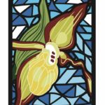 This is a Multi-Day HikeYou are signing up for the following dates:
2024-09-28, 2024-09-29, 2024-10-05 Click here for more information or to register Hosting Club: Caledon Hills, Dufferin Hi-Land
Category: End-to-End
Location (Google Maps): Mono Community Center – west of km 72.2, 200 m south of Mono Centre. Hike Leader(s): Roopa Dindigal Click here to contact Hike Leader(s) Pace: Medium – 3 to 4 km/hour
Terrain: Moderate – some hills and/or some poor footing
Distance: 19.4 + 450 metres Description
This series of hikes is a Fundraiser for the Dufferin Hi-Land Bruce Trail Club. All proceeds fund the activities of the Club directly. You are signing up for 3 hikes and must be present at 3 hikes to receive the beautiful Stained Glass Lady Slippers End-to-End badge, included in your registration We will hike North to Southbound, on Hike #1 -Sept 28th we will hike from Road Side Parking on 1st line km 19.4 to Mono Community Center -19.4 km + 450 metres. A detailed schedule for the full series, with dates and meeting locations, will be provided when you register. This hike series is meant for experienced distance hikers, please keep in mind your ability to join this series. - Please dress according to the weather presented that day
- Hikes will average 4 km per hour including breaks
- Expect to be on trail for 4 – 5 hours
- Meeting time is scheduled for an early start at 8:00 am so that we’re on the trail at the earliest part of the day
- You must arrive no later than 15 minutes before the meeting time to organize the shuttle & have your vehicle passenger ready, as everyone will be taking a turn either to start the hike or get drivers back at the end of the day.
- Hikers must carry sufficient hydration, accessible snacks, small lunch, first-aid kit, rain gear, extra socks, bug spray, etc; check the weather as you pack your gear
- If you have any questions or concerns, please use the Contact the Hike Leader above.
|
29  Bruce Trail Conservancy and Vieni Estates Presents: A Celebration of Partnership And Community Bruce Trail Conservancy and Vieni Estates Presents: A Celebration of Partnership And Community 10:00 AM-1:30 AM 09/29/2024 https://hikes.brucetrail.org/event/bruce-trail-conservancy-and-vieni-estates-presents-a-celebration-of-partnership-and-community/2024-09-29/ Click here for more information or to register Hosting Club: Niagara, Iroquoia, Toronto, Caledon Hills, Dufferin Hi-Land, Blue Mountains, Beaver Valley, Sydenham, Peninsula
Category: Event Hikes
Location (Google Maps): Vieni Estates Winery Hike Leader(s): Bess Maclaughlin Nakashima, Sam Rutherford Click here to contact Hike Leader(s) Pace: Leisurely, Medium
Terrain: Moderate
Distance: 3-5km Description
Join us in celebrating the ongoing relationship between Vieni Estates and the Bruce Trail Conservancy. Sam Rutherford will be guiding you on a 1-and-a-half-hour hike starting at Vieni Estates. We will return to our starting point for a wine tasting and lunch. Let’s celebrate this ongoing relationship as we look to the future!
| 30 - Peninsula End to End – Stained Glass Fundraiser
8:30 AM-2:30 AM 09/30/2024 https://hikes.brucetrail.org/event/peninsula-end-to-end-stained-glass-fundraiser/2024-09-30/ Hike open to BTC Members only. This is a Multi-Day HikeYou are signing up for the following dates and times:
2024-09-30 at 08:30
2024-10-01 at 07:30
2024-10-02 at 07:30
2024-10-03 at 07:30
2024-10-07 at 08:30
2024-10-08 at 07:30
2024-10-09 at 07:30
2024-10-10 at 07:30 Click here for more information or to register Hosting Club: Iroquoia, Caledon Hills, Peninsula
Category: Stained Glass Badge End to End Fundraiser Hike
Location (Google Maps): Halfway Dump Rd, Tobermory (Capacity 80) No reservation needed after Sept 2. Hike Leader(s): Steven White Click here to contact Hike Leader(s) Pace: Brisk – 4 to 5 km/hr
Terrain: Strenuous – Hilly with steep climbs and some poor footing
Distance: 24.4 Description
Hikes are co-led by Heather Murch (Caledon Hills) & Steven White (Iroquoia) This is an opportunity to achieve a Peninsula E2E badge (Heather) or donate to the Bruce Trail and earn a beautiful Peninsula E2E ‘stained glass’ badge (Steve). We are a group of friends who are hiking Cairn to Cairn starting after Labour Day and finishing before Christmas. We’ve decided this year to hike right through Club Boundaries. It helps us to maintain a more consistent number of km’s for each hike and it reduces the complexity of having to end at a certain spot (Club Boundary); which quite often don’t have parking right there.
We will generally be hiking the Peninsula section south; starting in Tobermory. We will hike 10.7 km into Sydenham (past Wiarton) on the last day.
You’re welcome to join us for the Peninsula section provided you can keep up to a pace that exceeds 4 km/hour. Rest of itinerary to be sent the week before our first hike. Hikers should wear layered clothing, hiking boots, poles, hat, and bring lunch, snacks, water, raingear
- Peninsula E2E
8:30 AM-1:30 PM 09/30/2024 https://hikes.brucetrail.org/event/peninsula-e2e/2024-09-30/ Hike open to BTC Members only. This is a Multi-Day HikeYou are signing up for the following dates and times:
2024-09-30 at 08:30
2024-10-01 at 07:30
2024-10-02 at 07:30
2024-10-03 at 07:30
2024-10-07 at 08:30
2024-10-08 at 07:30
2024-10-09 at 07:30
2024-10-10 at 07:30 Click here for more information or to register Hosting Club: Iroquoia, Caledon Hills, Peninsula
Category: End-to-End
Location (Google Maps): Halfway Dump (Capacity 80) No reservation needed after Sept 2. Hike Leader(s): Heather Murch Click here to contact Hike Leader(s) Pace: Brisk – 4 to 5 km/hour
Terrain: Strenuous – hilly with steep climbs and some poor footing
Distance: 24.4 km Description
Hikes are co-led by Heather Murch (Caledon Hills) & Steven White (Iroquoia) This is an opportunity to achieve a Peninsula E2E badge (Heather) or donate to the Bruce Trail and earn a beautiful Peninsula E2E ‘stained glass’ badge (Steve). We are a group of friends who are hiking Cairn to Cairn starting after Labour Day and finishing before Christmas. We’ve decided this year to hike right through Club Boundaries. It helps us to maintain a more consistent number of km’s for each hike and it reduces the complexity of having to end at a certain spot (Club Boundary); which quite often don’t have parking right there.
We will generally be hiking the Peninsula section southbound; starting in Tobermory. We will hike 10.7 km into Sydenham (past Wiarton) on the last day.
You’re welcome to join us for the Peninsula section provided you can keep up to a pace that exceeds 4 km/hour. Rest of itinerary to be sent the week before our first hike. Hikers should wear layered clothing, hiking boots, poles, hat, and bring lunch, snacks, water, raingear
- Hike 4 of 7 – Caledon HIlls E2E
9:15 AM-2:30 PM 09/30/2024 https://hikes.brucetrail.org/event/hike-4-of-7-caledon-hills-e2e/2024-09-30/  Click here for more information or to register Hosting Club: Caledon Hills
Category: End-to-End
Location (Google Maps): Meet at 9:15 at the Parking Lot on 7th Line, just east of Airport Road.
Shuttle to Innis Lake Road and Finnerty Sideroad Hike Leader(s): Jennie Greenfield Click here to contact Hike Leader(s) Pace: Medium – 3 to 4 km/hour
Terrain: Moderate – some hills and/or some poor footing, Strenuous – hilly with steep climbs and some poor footing
Distance: 12.02 km Description
Hike 4 of 7 – Caledon Hills E2E The trail heads north on Innis Lake Road then onto a road allowance descending into the Dingle, and continues up and down through Glen Haffy Conservation Area, across Highway 9, past a reservoir and crossing the Humber River and more hills to 7th Line. 31.5 to 43.3 + 0.22 side trails = 12.02 km (Edition 31) This hike can be logged towards the “60 for 60th Anniversary” badge
| October | October | October | October | October |