|
Sun | Mon | Tue | Wed | Thu | Fri | Sat |
|---|
August | August | 1  Long Hike Short Hills Long Hike Short Hills 8:00 AM-10:30 AM 09/01/2026 https://hikes.brucetrail.org/event/long-hike-short-hills-9/2026-09-01/ Click here for more information or to register Hosting Club: Niagara Location (Google Maps): Short Hills Wiley Road, Thorold Hike Leader(s): Alan Laver Pace: Brisk 4-5 km/hr
Terrain: Moderate: some hills and some poor footing
: 10k+ Description
Our regular Spot for the Tuesday Long Hike. Note the new location. We will hike the trails around Short Hills Dress for the weather and bring sunscreen bug spray, poles snack and drink
 Rock Hill/Oliver Creek Loop Rock Hill/Oliver Creek Loop 9:30 AM-12:00 PM 09/01/2026 https://hikes.brucetrail.org/event/rock-hill-oliver-creek-loop-2/2026-09-01/ Click here for more information or to register Hosting Club: Dufferin Hi-Land
Category: Tuesday Hike
Location (Google Maps): Dufferin Hi-Land, Map 20. Meet at Rock Hill parking lot on 1st Line Mulmur, just south of 10 Sideroad (Km 29.4). Hike Leader(s): Tony Evangelista, Les Babbage, Inge Eckerich, Julie Daley Click here to contact Hike Leader(s) Pace: Leisurely
Terrain: Moderate
Distance: 7.0 km; Short Hike: 2.4 km Description
We will hike the Main Trail, returning by way of the Oliver Creek and Moss Haven Side Trails. The short hike will return to parking from just past the top of the Enchanted Forest Side Trail, before the Main Trail descends into the Boyne Valley. Bring water and snacks. Hiking poles are recommended.
 Urban Walk: Valley View Park Urban Walk: Valley View Park 9:30 AM-11:45 AM 09/01/2026 https://hikes.brucetrail.org/event/car-hike-valley-view-huntington-park/2026-09-01/ Click here for more information or to register Hosting Club: Toronto Location (Google Maps): Parking lot is off Sycamore Drive, East of Bayview , across Starbucks plaza
Bus 91 from Finch East station stops at Sycamore station. Hike Leader(s): Mohammad Aghamiri Pace: Moderate (3-4 km/hr)
Terrain: Hilly, Level 2 (Intermediate – some hills and uneven surfaces, rocks and roots underfoot)
Distance (km): 6-7 km Description
We will explore Valleyview and Maple View parks, and walk along German Mills Creek, in return we stop in Huntington park and have snack under beautiful shed. Although this is considered an “Urban Walk”, you can expect some hills up and down and uneven surfaces with tree roots. Please bring hiking poles, water and snacks.
| 2 - Evening Hike in Owen Sound followed by an Opportunity for Refreshments
7:00 PM-8:45 PM 09/02/2026 https://hikes.brucetrail.org/event/evening-hike-in-owen-sound-followed-by-an-opportunity-for-refreshments-24/2026-09-02/ Click here for more information or to register Hosting Club: Sydenham
Category: An evening walk.
Location (Google Maps): Meet in the municipal parking lot by the river on the West side of first Ave East between 7th Ave East and 8th Ave East in Owen Sound. Hike Leader(s): Harriet Nixon Click here to contact Hike Leader(s) Pace: Brisk: 4 to 5 km/h
Terrain: Moderate: Some hills and/or poor footing
Distance: Approx 5 km Description
Join us for a brisk evening hike exploring Owen Sound paths and neighbourhoods, followed by an opportunity for refreshments. There is no need to show up 15 minutes early for this hike, but we will leave promptly at 7:00 pm.
| 3 - 8:00 am Long hike NEW Location. Bailey bridge Jordan
8:00 AM-10:30 AM 09/03/2026 https://hikes.brucetrail.org/event/800-am-long-hike-new-location-bailey-bridge-jordan-10/2026-09-03/ Click here for more information or to register Hosting Club: Niagara Location (Google Maps): Bailey bridge Jordan Hike Leader(s): Alan Laver Pace: Brisk 4-5 km/hr
Terrain: Strenuous: hilly, with steep climbs, poor footing
: ~10k Description
This will be our permanent location . Hike up from the Bailey bridge to Balls Falls and explore the trails You must register for each hike. Bring Poles, snack and a drink. Dress for the weather
- Toronto Fall Series Hike 1 of 9
9:30 AM-2:30 PM 09/03/2026 https://hikes.brucetrail.org/event/toronto-fall-series-hike-1-of-9/2026-09-03/ Click here for more information or to register Hosting Club: Caledon Hills
Category: End-to-End
Location (Google Maps): Meet at Boston Mills Road parking. Map 14, southwest of km 48.4 Hike Leader(s): Nancy Mooney Click here to contact Hike Leader(s) Pace: Medium – 3 to 4 km/hour
Terrain: Easy – mostly flat and usually good footing, Moderate – some hills and/or some poor footing
Distance: 13.5 km loop Description
This is the first hike of a Toronto End-to-End Series that will also include side trails. Most of the hikes in the series will be loops. This hike will take us along the main trail to the Rockside Side Trail then back to Boston Mills Road all the way to the Cheltenham Badlands before a post hike stop at the Spirit Tree Cidery.
 Mystery Trails Mystery Trails 10:00 AM-12:30 PM 09/03/2026 https://hikes.brucetrail.org/event/mystery-trails/2026-09-03/  Click here for more information or to register Hosting Club: Iroquoia
Category: General Hike
Location (Google Maps): City View Park, 2500 Kerns Rd. SOUTH Parking Lot Hike Leader(s): Anne Armstrong Click here to contact Hike Leader(s) Pace: Leisurely – 3km/hr or less
Terrain: Easy – Mostly flat and usually good footing, Moderate – Some hills and/or some poor footing
Distance: Approx. 8-9 km. Description
Join us to explore the many trails between Watertown and Kerns Rd. We will use a combination of Main Bruce Trail, Blue Side Trails and former Bruce Trail as well as trails of use. Meet in the SOUTH parking lot at 9:45 am. for a 10:00 am. start. Bring water, a snack and sunscreen. Expect some rocky areas. I will send out an email the day before with my contact details in the event you need to cancel in the morning.
 Hike, followed by Blues in the Park Hike, followed by Blues in the Park 5:30 PM-7:00 PM 09/03/2026 https://hikes.brucetrail.org/event/hike-followed-by-blues-in-the-park-10/2026-09-03/  Click here for more information or to register Hosting Club: Niagara
Category: Leisurely
Location (Google Maps): 2275 Dorchester Rd, Niagara Falls, ON L2J 0H1 Hike Leader(s): Marion Hanover Click here to contact Hike Leader(s) Pace: Leisurely <3 km/hr
Terrain: Moderate: some hills and some poor footing
Distance: 4km Description
Hike series Thursday evenings throughout the summer, followed by optional Blues in the Park. Come prepared to hike 1.5 leisure hike. Various blues bands free of charge starting at 7pm in the park. Bring lawn chair, beverage and snack to share.
| 4  9:00 am Niagara on the Lake Tour & Some Yoga 9:00 am Niagara on the Lake Tour & Some Yoga 9:00 AM-11:00 AM 09/04/2026 https://hikes.brucetrail.org/event/900-am-niagara-on-the-lake-tour-some-yoga-30/2026-09-04/  Hike open to BTC Members only. Click here for more information or to register Hosting Club: Niagara
Category: Urban
Location (Google Maps): Veteran’s Memorial Park, park just outside the park on King St. Hike Leader(s): Robin Garrett Click here to contact Hike Leader(s) Pace: Leisurely <3 km/hr Distance: 5 km Description
Enjoy the benefits of pausing for a yoga practice as we tour through the trails, parkland and Historic Niagara-on-the-Lake. No mat required. Movement will focus on a flow of standing poses designed especially for hikers. Plan to stay for conversation and a warm cup of coffee or tea at Sweets & Swirls, Community Centre, Niagara Stone Road, NOTL.
| 5  Peninsula End2End in 8 Series Peninsula End2End in 8 Series 7:00 AM 09/05/2026 https://hikes.brucetrail.org/event/peninsula-end2end-in-8-series-3/2026-09-05/  Hike open to BTC Members only. This is a Multi-Day HikeYou are signing up for the following dates and times:
2026-09-05 at 07:00
2026-09-06 at 07:00
2026-09-12 at 07:00
2026-09-13 at 07:00
2026-09-19 at 07:00
2026-09-20 at 07:00
2026-10-17 at 07:00
2026-10-18 at 07:00 Click here for more information or to register Hosting Club: Peninsula
Category: Peninsula E2E
Location (Google Maps): Hike Leader(s): Saabir Sohrab Click here to contact Hike Leader(s) Pace: Medium (3.0 – 4.5 km/h): A comfortable pace for most hikers with steady progress.
Terrain: Difficult: Steep ascents/descents, rocky scrambling, and some rugged escarpment paths., Moderate: Rolling hills, mild slopes and rocky paths.
Distance: Approx. ~166km Description
Peninsula E2Ein8 Route: Wiarton to Tobermory (northbound) Pace: Medium (target 3–4 km/h) Terrain: Moderate to Difficult Distance: ~166 km total Daily Distances: 25.1 km ·19.2 km · 22.8 km · 21.5 km · 20 km · 11 km · 22.6 km · 23.6 km Expectations: Expect 5–8 hours on the trail each day, depending on distance, terrain, weather, and group pace. The hike leader sets the pace, aiming for 3–4 km/h, and may adjust as needed for group ability and trail conditions. Breaks will be taken throughout the day. For safety, participants must remain between the hike leader and the hike sweep at all times. Meeting Time: 7:00 AM Fees: - Registration fee does not include Bruce Peninsula National Park entry fees, Cape Croker Park or MNBP parking fees
- Parking costs will be shared equally among participants.
- Badge fee included, with your choice of either the flowerpot badge or the stained glass (Turkey Vulture or Black Bear) badge.
- Fundraising: This hike is a fundraiser to support the Peninsula Bruce Trail Club’s volunteer-run hike program
Participant Requirements - Intermediate/experienced hikers with good fitness
- Proper hiking boots, layered clothing, wet weather gear
- Hiking poles recommended
- Bring: Lunch, snacks, water, bug spray
Transportation & Accommodations - Car shuttle: Participants rotate as drivers; vehicles must be passenger-ready
- Accommodations: Book early; options include motels, campgrounds, hostels, and B&Bs
Note: Dogs are not permitted.
 Car Hike: Oak Ridges Corridor Car Hike: Oak Ridges Corridor 8:30 AM-1:00 PM 09/05/2026 https://hikes.brucetrail.org/event/car-hike-oak-ridges-corridor-3/2026-09-05/ Click here for more information or to register Hosting Club: Toronto Location (Google Maps): Oak Ridges Corridor, Bethesda Trail Head Parking Lot, Bethesda Side Road, Richmond Hill, Ontario Hike Leader(s): MOHAMMAD AGHAMIRI Click here to contact Hike Leader(s) Pace: Moderate (3-4 km/hr)
Terrain: Hilly, Level 2 (Intermediate – some hills and uneven surfaces, rocks and roots underfoot)
Distance (km): 14-15 km Description
Join us to explore the trails of York Regional Forest and the Oak Ridges Corridor at Jefferson Forest and Bond lake, From parking lot we hike thought Jefferson forest and continue to Bond Lake and have snack beside the lake and return to parking around 1:pm Please bring lots of water and snacks ,hiking poles are recommended,it is Mosquto and Tick season ,be prepared . phone number for the day of hike 289 588 6482
- Tobermory, 1 of 3, Map 41
10:00 AM-3:00 PM 09/05/2026 https://hikes.brucetrail.org/event/tobermory-1-of-3-map-41/2026-09-05/ Click here for more information or to register Hosting Club: Toronto, Peninsula
Category: Car Hike
Location (Google Maps): Bruce Peninsula PP Hike Leader(s): Alex Brown Click here to contact Hike Leader(s) Pace: Moderate (3-4 km/hr)
Terrain: Rocky, Variable
Distance (km): 13 km Description
This hike is a continuation of the Lions Head series. We will complete three hikes over the weekend, ending at the cairn in Tobermory. We will start at km 125.4 on Crane Lake Road, following the trail to the shore of Georgian Bay and end ending at the parking area at Halfway Dump Road. The meeting location for the morning will be at the Halfway Dump Parking Lot. Parking fees will apply For those coming long distance, local accommodation should be available in Tobermory. More information about the hike will be posted closer to the date.
|
6 - The Train Wreck Hike
9:30 AM-1:00 PM 09/06/2026 https://hikes.brucetrail.org/event/the-train-wreck-hike-2/2026-09-06/ Click here for more information or to register Hosting Club: Caledon Hills
Category: General
Location (Google Maps): Meet at the roadside parking at the junction of Escarpment Side Road and Willoughby Road, km 15.9 (Map 15).
Car Pool to roadside parking at Mountain View Side Trail on Mountain View Road. Google Map Coordinates: 43.894254, -79.922522, north of km 26.8 (Map 15). Hike Leader(s): Dan Revington Click here to contact Hike Leader(s) Pace: Medium – 3 to 4 km/hour
Terrain: Moderate – some hills and/or some poor footing
Distance: 10.2 km Description
In September 1907, a passenger train went off the tracks on the steep Horseshoe Valley Curve on the Niagara Escarpment. Seven people were killed and dozens were injured. The Bruce Trail passes close to the location of this disaster. Join us for a hike that includes a stop at the historic St. Andrew’s Stone Church Cemetery, panoramic views from Escarpment Road, and to learn about the tragic story and mystery of the famous Horseshoe Curve Rail Disaster. Bring your choice of hydration and snacks. We will be going through the forest, as well as walking on roads. There is one steep hill. Sturdy footwear is essential. Note: this is a car pool hike.
- Tobermory, 2 of 3, Map 41/42
10:00 AM-4:00 PM 09/06/2026 https://hikes.brucetrail.org/event/tobermory-2-of-3-map-41-42/2026-09-06/ Click here for more information or to register Hosting Club: Toronto, Peninsula
Category: Car Hike
Location (Google Maps): Bruce Peninsula PP Hike Leader(s): Alex Brown Click here to contact Hike Leader(s) Pace: Moderate (3-4 km/hr)
Terrain: Challenging, Rocky, Variable
Distance (km): 17 km Description
This is the second of two hikes in this series. During this hike we will pass through the Bruce Peninsula PP., mostly along Georgian Bay. Excellent views of the Bay. This hike is longer due to access limitations
| 7 - Tobermory, 3 of 3, Map 42
10:30 AM-2:00 PM 09/07/2026 https://hikes.brucetrail.org/event/tobermory-3-of-3-map-42/2026-09-07/ Click here for more information or to register Hosting Club: Toronto, Peninsula
Category: Car Hike
Location (Google Maps): Little Cove to Tobermory Hike Leader(s): Alex Brown Click here to contact Hike Leader(s) Pace: Moderate (3-4 km/hr)
Terrain: Variable
Distance (km): 8-10 km Description
This is the third and last hike in this series, ending at the cairn in Tobermory. This hike will be shorter, allowing for an early departure for those wishing to head home. An optional hike on the Burnt Point Loop Side Trail is available for those interested. We will start at the Little Cove parking lot. Parking fee will apply. More information about this hike will be posted close to the date.
| 8 - Long Hike Short Hills
8:00 AM-10:30 AM 09/08/2026 https://hikes.brucetrail.org/event/long-hike-short-hills-10/2026-09-08/ Click here for more information or to register Hosting Club: Niagara Location (Google Maps): Short Hills Wiley Road, Thorold Hike Leader(s): Alan Laver Pace: Brisk 4-5 km/hr
Terrain: Moderate: some hills and some poor footing
: 10k+ Description
Our regular Spot for the Tuesday Long Hike. Note the new location. We will hike the trails around Short Hills Dress for the weather and bring sunscreen bug spray, poles snack and drink
- Northern Bruce Trail Four Day Sampler- Beaver Valley, Sydenham and Peninsula
9:30 AM-3:30 PM 09/08/2026 https://hikes.brucetrail.org/event/northern-bruce-trail-four-day-sampler-beaver-valley-sydenham-and-peninsula/2026-09-08/  This is a Multi-Day HikeYou are signing up for the following dates and times:
2026-09-08 at 09:30
2026-09-09 at
2026-09-10 at Click here for more information or to register Hosting Club: Sydenham
Category: General Hike
Location (Google Maps): Metcalfe Rock parking lot on east side of 10th Line, Ravenna. Hike Leader(s): Karen Buschert Click here to contact Hike Leader(s) Pace: Medium: 3 to 4 km/h
Terrain: Moderate: Some hills and/or poor footing
Distance: Distances each day are 11-14 km Description
On this multi-day series of sampler hikes, discover some amazing loop trails in the northern three sections of the Bruce Trail. Hikes are moderate in length and difficulty and time will be taken to experience and observe the special features in each of these sections. This is a great introduction for those new to hiking the Bruce Trail and also for seasoned hikers that want to explore and/or revisit some great spots! Day 1 in Beaver Valley: Metcalfe Rock loop (9 km) and Old Baldy Lookout (2.5 km). These are two separate hikes and we will drive from one to the next.
Day 2 in Sydenham: Bayview Escarpment loop (14 km)- a mix of forested ridge and field and roadside to close the loop.
Day 3 in Peninsula : Sydney Bay Bluff loop (7 km) and Rush Cove loop (5 km) *these hikes have a major climb on a ladder and some difficult footing. But wow. Views….
Day 4 (if staying overnight): Choose your own adventure! I can make suggestions or you can hit your favourite destination or goal hike before heading for home! Accommodation suggestion: Silver Lake Mennonite Camp near Sauble Beach. Shared accommodations with food provided. Carpooling from camp will be arranged for those who will be staying there. Cost is $400 + HST per person and includes 3 nights, 3 suppers, 3 lunches and 3 breakfasts. Option to stay Monday night is an extra $60+ HST (food not included). Sauna, swimming and canoeing available for after the hikes. For further details contact hike leader and/or visit Silver Lake’s website: slmc.ca/retreats/ *No dogs*
- Terra Cotta Conservation Area Loop Hike
9:30 AM-1:00 AM 09/08/2026 https://hikes.brucetrail.org/event/terra-cotta-conservation-area-loop-hike/2026-09-08/ Click here for more information or to register Hosting Club: Dufferin Hi-Land
Category: Tuesday Hike
Location (Google Maps): Caledon Hills Section, Map 14. To car pool, meet at Party City (4th Ave at Hwy 10 in Orangeville) at 9:00 am or meet at roadside parking on Heritage Rd, north of King Rd, west of Mississauga Rd, Terra Cotta (Km 44.9) at 9:30 am. Hike Leader(s): Les Babbage, Julie Daley, Inge Eckerich, Tony Evangelista Click here to contact Hike Leader(s) Pace: Leisurely
Terrain: Moderate
Distance: 10 km with a shorter option available. Description
From Heritage Rd we will hike west along the Main Trail, through Terra Cotta Conservation Area. We will return along the Terra Cotta Side Trail (Caledon Trailway) to Heritage Rd. Terrain is mostly flat, with some hills, and a steep section. This is a 10 km hike with an option to turn back for a 5 km hike. Bring lunch, snacks and water.
| 9 - HIking for Butter Tarts – Old Guelph Road to Dyments and Back
9:00 AM-2:00 AM 09/09/2026 https://hikes.brucetrail.org/event/hiking-for-butter-tarts-old-guelph-road-to-dyments-and-back/2026-09-09/  Hike open to BTC Members only. Click here for more information or to register Hosting Club: Iroquoia
Category: General Hike
Location (Google Maps): Old Guelph Road at Tunnel – BTC parking where Old Guelph Road ends west side of highway 6,south of Clappisons Hike Leader(s): Lois Corey Click here to contact Hike Leader(s) Pace: Medium – 3 to 4 km/hr
Terrain: Moderate – Some hills and/or some poor footing
Distance: 16 kms Description
This is an out and back hike, no carpooling required. We will hike at a moderate-brisk pace from highway 6 West along Bruce Trail, deviating from the trail at the half way point, for a brief stop at Dyments Farm Market for butter tarts (or whatever catches your fancy), perhaps a little side trip to the Sydenham Lookout. Some climbing up and down escarpment between Old Guelph Road and Borers Falls, but lots of flat through Rock Chapel area to Dyments along the edge of the escarpment with some great views. Please dress appropriately for the weather and poles recommended. Please bring water and snacks/lunch. Any questions may be directed through contact on this form. If you cannot make it, please remove yourself from registration by following these steps:To cancel your registration, here is a step by step:
– Sign into your account on the BTC website
– Click on My Hikes under your account
– This will take you to a list of hikes you have registered for
– Scroll down to the appropriate hike and cursor over to the far right hand column under the Action column.
– Click Cancel under the hike you wish to cancel
| 10 - 8:00 am Long hike NEW Location. Bailey bridge Jordan
8:00 AM-10:30 AM 09/10/2026 https://hikes.brucetrail.org/event/800-am-long-hike-new-location-bailey-bridge-jordan-11/2026-09-10/ Click here for more information or to register Hosting Club: Niagara Location (Google Maps): Bailey bridge Jordan Hike Leader(s): Alan Laver Pace: Brisk 4-5 km/hr
Terrain: Strenuous: hilly, with steep climbs, poor footing
: ~10k Description
This will be our permanent location . Hike up from the Bailey bridge to Balls Falls and explore the trails You must register for each hike. Bring Poles, snack and a drink. Dress for the weather
- Toronto Fall Series Hike 2 of 9
9:30 AM-2:30 PM 09/10/2026 https://hikes.brucetrail.org/event/toronto-fall-series-hike-2-of-9/2026-09-10/ Click here for more information or to register Hosting Club: Caledon Hills
Category: End-to-End
Location (Google Maps): Meet at Heritage Road Parking, Map 14, southeast of km 44.6 where the Main Trail meets Heritage Rd. Hike Leader(s): Nancy Mooney Click here to contact Hike Leader(s) Pace: Medium – 3 to 4 km/hour
Terrain: Easy – mostly flat and usually good footing, Moderate – some hills and/or some poor footing
Distance: 14.5 km loop Description
This is the second hike in the series and will take us around Terra Cotta Conservation Area. It will include the Walking Fern and Terra Cotta Side Trails.
- Hike, followed by Blues in the Park
5:30 PM-7:00 PM 09/10/2026 https://hikes.brucetrail.org/event/hike-followed-by-blues-in-the-park-11/2026-09-10/  Click here for more information or to register Hosting Club: Niagara
Category: Leisurely
Location (Google Maps): 2275 Dorchester Rd, Niagara Falls, ON L2J 0H1 Hike Leader(s): Marion Hanover Click here to contact Hike Leader(s) Pace: Leisurely <3 km/hr
Terrain: Moderate: some hills and some poor footing
Distance: 4km Description
Hike series Thursday evenings throughout the summer, followed by optional Blues in the Park. Come prepared to hike 1.5 leisure hike. Various blues bands free of charge starting at 7pm in the park. Bring lawn chair, beverage and snack to share.
| 11 - Beaver Valley E2E in 8 – Hike 3
8:30 AM-2:30 PM 09/11/2026 https://hikes.brucetrail.org/event/beaver-valley-e2e-in-8-hike-3/2026-09-11/ Hike open to BTC Members only. Click here for more information or to register Hosting Club: Iroquoia
Category: General Hike
Location (Google Maps): Roadside Parking – north shoulder Sideroad 7B Hike Leader(s): Pati Greenwood, Jeff Dowsett Click here to contact Hike Leader(s) Pace: Medium – 3 to 4 km/hr
Terrain: Moderate – Some hills and/or some poor footing, Strenuous – Hilly with steep climbs and some poor footing
Distance: 15.8 km Description
This is hike 3 of the End-to-End hike series to complete the Beaver Valley section of the Bruce Trail in 8 hikes. Join for all or as many hikes as desired – you will need to register for each hike in the series which will take place on the following dates: August 28, August 29, September 11, September 12, October 2, October 3, October 16 & October 17. Hikers completing the entire series will be eligible to obtain an end-to-end badge from the BTC Beaver Valley Club. Since this is a group hike, please consider your fitness level before registering. This section of the trail has numerous hills and rough terrain in spots. We will be walking at a pace of 3km – 4km per hour and hikers will need to keep up with the person in front of them for the duration of the hike. The hike series will also involve car shuttles and every hiker is expected to participate as drivers. Weather conditions in the late summer can still be quite warm, but the hike schedule will extend to mid-October so it’s best come prepared for varying weather conditions. Hiking boots are required and hiking poles are strongly recommended. Bring plenty of fluids and a snack. Insects and ticks will still be active at this time of year, long pants and long sleeves are recommended as is insect repellent. Specific hike details will be provided to registered hikers a few days prior to each hike.
- 9:00 am Niagara-on-the-Lake Tour
9:00 AM-10:30 AM 09/11/2026 https://hikes.brucetrail.org/event/900-am-niagara-on-the-lake-tour-63/2026-09-11/  Hike open to BTC Members only. Click here for more information or to register Hosting Club: Niagara
Category: Urban
Location (Google Maps): Veterans Memorial Park, park just outside the park on King Street Hike Leader(s): Robin Garrett Click here to contact Hike Leader(s) Pace: Leisurely <3 km/hr Distance: 6-7 km Description
Each Friday we will explore different neighbourhoods, trails and parkland throughout Historic Niagara-on-the-Lake. Moderate pace with some weeks entirely on sidewalks and roads while others may include a mix of trails and paved pathways. Great way to build up endurance for longer more strenuous hikes. Prepare for cooler windy conditions on open parkland and along Lake Ontario and Niagara River trails. Plan to stay for conversation and a warm cup of coffee or tea at Sweets & Swirls, Community Centre, Niagara Stone Road, NOTL
| 12 - Peninsula Sunrise Series: Malcolm Bluff
6:00 AM 09/12/2026 https://hikes.brucetrail.org/event/peninsula-sunrise-series-malcolm-bluff-2/2026-09-12/  Click here for more information or to register Hosting Club: Peninsula
Category: Sunrise Hike
Location (Google Maps): Purple Valley Access Trail Parking Hike Leader(s): Kathleen Stahlbaum Click here to contact Hike Leader(s) Pace: Leisurely (2.0 – 3.0 km/h): A relaxed pace with frequent breaks and a focus on enjoyment., Medium (3.0 – 4.5 km/h): A comfortable pace for most hikers with steady progress.
Terrain: Difficult: Steep ascents/descents, rocky scrambling, and some rugged escarpment paths., Easy: Flat forested sections or lowland trails., Moderate: Rolling hills, mild slopes and rocky paths.
Distance: 6.5 km Description
Experience the magic of dawn on the Bruce Trail with the Sunrise Hike Series offered by the Peninsula Bruce Trail Club. These early morning hikes provide a perfect opportunity to awaken your senses, boost your energy, and immerse yourself in the tranquility of nature as the sun paints the sky with breathtaking hues. As we make our way through scenic forest trails, we’ll pause to witness the first light shimmering on the turquoise waters of Georgian Bay – a sight that will surely leave you in awe! Beyond the beauty, morning light helps regulate your circadian rhythm, elevating your mood, boosting energy levels and improving sleep quality. Whether you’re looking to start your day with a sense of calm, capture stunning sunrise photos, or simply reconnect with nature, these hikes offer a unique and inspiring way to greet the day. On Saturday September 12th, join us in hiking along the Purple Valley Access Trail, Malcolm Bluff Side Trail, and stretch of Main Trail through the Malcolm Bluff Shores Nature Reserve to experience the sun rising over the Bay from the edge of the Escarpment. We’ll have the joy of taking in the stunning colours of the sky as the first light sparkles on the stunning turquoise waters. This peaceful sunrise hike is the perfect way to connect with nature, capture some incredible photos, and start the day with fresh air and inspiration. Whether you’re a morning person or just love a good adventure, come experience the magic of dawn from one of the best vantage points on the Bruce Peninsula! Don’t forget to bring a headlamp or flashlight (preferably with a red light setting) as we begin our adventure in the pre-dawn quiet. Join us and discover how a sunrise hike can nourish your mind, body, and spirit—setting the tone for a brighter, more balanced day. This hike is approximately 6.5 kms in length. Expect to be on the trail for 2-3 hours. Pace will be leisurely with ample time to enjoy the sunrise, take some photographs, and nourish yourself! How to prepare: - Get a good night’s sleep
- Bring lots of water and a snack (breakfast and/or coffee are recommended if that’s your thing!)
- Bring a headlamp or flashlight (preferably with a red light setting)
- Wear waterproof hiking boots
- Hiking poles are recommended but not necessary
- Bring insect repellant or wear protective clothing
- Bring sunscreen
In the event of cloudy/rainy weather, the hike will be held on Sunday, September 13th. Please watch your emails for a confirmation the week of the hike!
-
 Two Day Toronto End-to-End Event (participants hike independently, no hike leader) Two Day Toronto End-to-End Event (participants hike independently, no hike leader) 7:30 AM-4:00 PM 09/12/2026 https://hikes.brucetrail.org/event/two-day-toronto-end-to-end-event-participants-hike-independently-no-hike-leader-2/2026-09-12/  This is a Multi-Day HikeYou are signing up for the following dates:
2026-09-12, 2026-09-13 Click here for more information or to register Hosting Club: Toronto
Category: Annual TBTC E2E
Location (Google Maps): The Toronto Bruce Trail section which runs from just south of Hilton Falls CA on Appleby Line to the south entrance of the Cheltenham Badlands on Creditview Rd. On both days, we will meet in the village of Limehouse. The exact parking location in Limehouse will be emailed closer to the event date. Hike Leader(s): Jacqueline Van Dyke Click here to contact Hike Leader(s) Pace: Brisk (4-5 km/hr)
Terrain: Challenging, Level 2 (Intermediate – some hills and uneven surfaces, rocks and roots underfoot)
Distance (km): Saturday, Sept. 12 – 28km/Sunday, Sept. 13 – 22km Description
Hike the Toronto section of the Bruce Trail over two days. Hikers must maintain a minimum pace of 4km/hr and reach the checkpoints by the cutoff time in order to continue. On Saturday, the buses will bring hikers from Limehouse to the south entrance of the Cheltenham Badlands where the hike will begin. Hikers will hike south to their vehicles in Limehouse – a distance of approximately 28km. Hikers will reach checkpoint 1 at km 38.8 (after hiking 11.6km) by 11:00 am and checkpoint 2 at km 27.8 (after hiking 11km) by 1:45 pm in order to continue. On Sunday, the buses will bring hikers from Limehouse, to km 0.0 on Appleby Line where the hike will begin. Hiking north to Limehouse, hikers must reach checkpoint 1 at km 11.4 in the Pear Tree parking lot by 11:00 am to continue. There will be sweeps on both days to assist hikers when needed. Water refill and refreshments will be available at the checkpoints. Bring your fully charged cell phone, basic 1st aid supplies, and a water bottle. Those who complete the distances on both days within the prescribed time limits will receive the special NEW 2 Day Club E2E badge. The registration fee includes the online registration fee, bus shuttle, refreshments, and the official NEW E2E badge. If any spots are still available at 9:00 am on July 8, registration will also be opened to non-members (child and adult) at a cost of $65. These are strenuous hikes suitable for experienced, long distance, faster paced hikers over the age of 16. Space is limited, hikes go rain or shine, and no dogs are permitted on this event. Hikers must find their own way each morning to the meeting point in Limehouse. Buses will leave Limehouse promptly at 8:00 am. There will be no refunds or tax receipts issued for anyone who cancels their registration. For questions, please contact Jacquie Van Dyke at vdyke0946@gmail.com. Registration closes at midnight on September 6, 2026. On September 1 or before, an email will go out to all participants with the exact parking location in Limehouse.
- Six Pack Of Blue – Hike 3 of 6
8:15 AM-3:00 AM 09/12/2026 https://hikes.brucetrail.org/event/six-pack-of-blue-hike-3-of-6/2026-09-12/ Click here for more information or to register Hosting Club: Blue Mountains
Category: End-to-End
Location (Google Maps): Nottawasaga Bluffs parking lot – parking fee Hike Leader(s): Rob Johnston Click here to contact Hike Leader(s) Pace: Medium – 3 to 4 km/hr
Terrain: Moderate – Some hills and/or some poor footing
Distance: 10.1 Description
Please join us for the Six Pack Of Blue! This is an End-to-End of the Blue Mountains section of the Bruce Trail completed in 6 hikes – see below for dates. You can do as many of the six hikes as you wish. Hike distances in this six-hike series range from 8 km to 14.6 km. This is Hike #3. The route is from Nottawasaga Bluffs Parking Lot to Conc 10 road crossing, covering approximately 10.1 km. The pace will be 3–4 km/hour, and all hikers must be able to maintain this speed. The terrain is hilly with uneven, rocky footing. Sturdy hiking footwear is required, and hiking poles are recommended. Please bring water and a snack. Due to limited parking at trailheads, this hike will involve a car shuttle. All hikers are expected to carpool and share the associated costs. Arrive at the meeting location by 8:15 a.m. The car shuttle will depart promptly at 8:30 a.m. Further details will be provided to registered hikers a few days before the hike. Please refer to each individual hike date as outlined below for specific details of that hike. Register for each hike you plan to attend. The hikes are on the following dates: 20 June 2026 27 June 2026 12 Sept 2026 19 Sept 2026 26 Sept 2026 17 Oct 2026
- Beaver Valley E2E in 8 – Hike 4
8:30 AM-2:30 PM 09/12/2026 https://hikes.brucetrail.org/event/beaver-valley-e2e-in-8-hike-4/2026-09-12/ Hike open to BTC Members only. Click here for more information or to register Hosting Club: Iroquoia, Beaver Valley
Category: General Hike
Location (Google Maps): Eugenia Falls Conservation Area Parking Lot – Fee required Hike Leader(s): Pati Greenwood, Jeff Dowsett Click here to contact Hike Leader(s) Pace: Medium – 3 to 4 km/hr
Terrain: Moderate – Some hills and/or some poor footing, Strenuous – Hilly with steep climbs and some poor footing
Distance: 13.8 km Description
This is hike 4 of the End-to-End hike series to complete the Beaver Valley section of the Bruce Trail in 8 hikes. Join for all or as many hikes as desired – you will need to register for each hike in the series which will take place on the following dates: August 28, August 29, September 11, September 12, October 2, October 3, October 16 & October 17. Hikers completing the entire series will be eligible to obtain an end-to-end badge from the BTC Beaver Valley Club. Since this is a group hike, please consider your fitness level before registering. This section of the trail has numerous hills and rough terrain in spots. We will be walking at a pace of 3km – 4km per hour and hikers will need to keep up with the person in front of them for the duration of the hike. The hike series will also involve car shuttles and every hiker is expected to participate as drivers. Weather conditions in the late summer can still be quite warm, but the hike schedule will extend to mid-October so it’s best come prepared for varying weather conditions. Hiking boots are required and hiking poles are strongly recommended. Bring plenty of fluids and a snack. Insects and ticks will still be active at this time of year, long pants and long sleeves are recommended as is insect repellent. Specific hike details will be provided to registered hikers a few days prior to each hike.
- Car Hike: Boyd C.A.
8:30 AM-1:15 PM 09/12/2026 https://hikes.brucetrail.org/event/car-hike-boyd-conservation-park-vaughan-17/2026-09-12/ Click here for more information or to register Hosting Club: Toronto Location (Google Maps): Free Parking lot before entrance of park on Islington Ave. Hike Leader(s): Mohammad Aghamiri Click here to contact Hike Leader(s) Pace: Moderate (3-4 km/hr)
Terrain: Hilly, Level 2 (Intermediate – some hills and uneven surfaces, rocks and roots underfoot), Variable
Distance (km): 12-14 km Description
Let’s hike Boyd conservation park trails through beautiful valleys. Please bring lots of water and snacks ,hiking poles are recommended phone number for the day of hike 289 588 6482
- Saturday Shorts: Griffith Ravine Side Trail Hike
9:30 AM-11:30 AM 09/12/2026 https://hikes.brucetrail.org/event/saturday-shorts-griffith-ravine-side-trail-hike/2026-09-12/ Click here for more information or to register Hosting Club: Caledon Hills
Category: General
Location (Google Maps): Meet at the roadside parking next to Peter Beecham Side Trail, km 54.6, Map 18. This is on 4th line EHS, north of #5 Sideroad and south of Hockley Road.
Please arrive by 9:15 a.m. so we can start the hike promptly at 9:30 a.m. Hike Leader(s): Dan Revington Click here to contact Hike Leader(s) Pace: Leisurely – 3 km/hour or less
Terrain: Moderate – some hills and/or some poor footing
Distance: Approximately 5 km Description
On this Saturday Shorts hike, we will enjoy an invigorating hike along a beautiful trail on an iconic Canadian September morning, and discover why world famous artist Julius Griffith and his wife Lialia inspired the naming of the Griffith Ravine Side Trail. The distance is not long, and the pace will be leisurely, but the Trail goes down a steep slope to the valley and there is a steep climb back up. Sturdy footwear is required. Bring water. Hiking poles are recommended. No dogs please. You can expect a reminder/update message one or two days before the hike.
|
13 | 14 | 15 - Long Hike Short Hills
8:00 AM-10:30 AM 09/15/2026 https://hikes.brucetrail.org/event/long-hike-short-hills-11/2026-09-15/ Click here for more information or to register Hosting Club: Niagara Location (Google Maps): Short Hills Wiley Road, Thorold Hike Leader(s): Alan Laver Pace: Brisk 4-5 km/hr
Terrain: Moderate: some hills and some poor footing
: 10k+ Description
Our regular Spot for the Tuesday Long Hike. Note the new location. We will hike the trails around Short Hills Dress for the weather and bring sunscreen bug spray, poles snack and drink
- Meltwater Moraine and Songbird Side Trail
9:30 AM-12:00 PM 09/15/2026 https://hikes.brucetrail.org/event/meltwater-moraine-and-songbird-side-trail/2026-09-15/ Click here for more information or to register Hosting Club: Dufferin Hi-Land
Category: Tuesday Hike
Location (Google Maps): Caledon Hills Section, Map 16: Meet in the parking lot at the farm on the east side of Mountainview Rd (between Escarpment Sideroad and Charleston Sideroad).
Note: The trails we will be hiking are not shown in the BT Guide. You can preview maps on the Trail Changes and Notices section of the BTC website or on the BTC app. Hike Leader(s): Julie Daley, Les Babbage, Tony Evangelista, Inge Eckerich Click here to contact Hike Leader(s) Pace: Leisurely
Terrain: Moderate
Distance: Long Hike 7 km, Short hike: 4.5 km Description
We will hike along the Main Trail in the Moraine, through forest and fields, to Airport Rd. Those wishing a short hike will return to the parking lot from here. The hike will continue with a short walk south on Airport Rd and on the Songbird Side Trail, then return to the parking lot on Mountainview Rd. Bring water and snacks, insect repellent and hiking poles, as needed.
| 16 - 9:30 am Hike & Picnic
9:30 AM-12:00 PM 09/16/2026 https://hikes.brucetrail.org/event/930-am-hike-picnic-3/2026-09-16/
| 17 - 8:00 am Long hike NEW Location. Bailey bridge Jordan
8:00 AM-10:30 AM 09/17/2026 https://hikes.brucetrail.org/event/800-am-long-hike-new-location-bailey-bridge-jordan-12/2026-09-17/ Click here for more information or to register Hosting Club: Niagara Location (Google Maps): Bailey bridge Jordan Hike Leader(s): Alan Laver Pace: Brisk 4-5 km/hr
Terrain: Strenuous: hilly, with steep climbs, poor footing
: ~10k Description
This will be our permanent location . Hike up from the Bailey bridge to Balls Falls and explore the trails You must register for each hike. Bring Poles, snack and a drink. Dress for the weather
- Toronto Fall Series Hike 3 of 9
9:30 AM-2:30 PM 09/17/2026 https://hikes.brucetrail.org/event/toronto-fall-series-hike-3-of-9/2026-09-17/ Click here for more information or to register Hosting Club: Caledon Hills
Category: End-to-End
Location (Google Maps): Meet at Scotsdale Farm Parking. Map 13 north of km 29.8. Hike Leader(s): Nancy Mooney Click here to contact Hike Leader(s) Pace: Medium – 3 to 4 km/hour
Terrain: Moderate – some hills and/or some poor footing, Strenuous – hilly with steep climbs and some poor footing
Distance: 14.2 km loop Description
This is the third hike of the series. We will loop around Scotsdale Farm and Silvercreek Conservation Area including Roberts, Irwin Quarry, and part of Bennett Heritage Side Trails.
| 18 | 19 - 2026 Iroquoia E2E in Four (Two concurrent weekends)
7:00 AM-5:00 AM 09/19/2026 https://hikes.brucetrail.org/event/2026-iroquoia-e2e-in-four-two-concurrent-weekends/2026-09-19/ 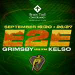 This is a Multi-Day HikeYou are signing up for the following dates and times:
2026-09-19 at 07:00
2026-09-20 at 07:00
2026-09-26 at 07:00
2026-09-27 at 07:00 Click here for more information or to register Hosting Club: Iroquoia
Category: Special Event
Location (Google Maps): Two different parking locations (one for each wknd) will be provided to registered hikers only. The Bus will be there to take you to the hike start.
Any unregistered hikers who show up will not be permitted to board the buses. Hike Leader(s): Joe Borges Click here to contact Hike Leader(s) Pace: Brisk – 4 to 5 km/hr
Terrain: Dependent on Conditions, Strenuous – Hilly with steep climbs and some poor footing
Distance: 122km (30-35 each day) // Self-paced with mandatory checkpoint deadlines Description
Please join us for the annual Iroquoia Bruce Trail Club self-paced End-to-End. You can enjoy and complete the entire club distance of 122 km over four days (approximately 30-35km each day). Please be honest about your physical abilities. These 4 days are not recommended for new hikers or anyone who hasn’t completed these distances recently.
The registration fee is non-refundable. The hikes will traverse the varied and often strenuous terrain from Grimbsy in the south, to the 401 in Milton. You will pass many waterfalls and beautiful vistas. Checkpoint stations will be approximately every 10 km offering snacks, water refill, and assistance. Please bring your own First Aid Kit. The hike is $95 for members and $110 for non-members (if there are still available spots after the member pre-sale) and includes bus transportation from the meeting point to the hike starting point, refreshments, parking, permit costs, and the official E2E badge. The fee is non-refundable. After costs, the proceeds go to the Iroquoia Bruce Trail Club who support The Bruce Trail Conservancy mission of “Preserving a ribbon of wilderness, for everyone, forever.” PLEASE NOTE: Registration opens at 8am on February 22, 2026 for Bruce Trail Conservancy members only.
You may be a member of any club. If any spots are still available after the first two weeks, registration will also be opened for non-members at a cost of $110. Details will be emailed to participants. As mentioned, these are longer hikes and are not suitable for beginning hikers. For both events, hikers are expected to maintain an average pace of 4 km/hr (or more). Hikers will be required to reach each checkpoint on each day by a prescribed time in order to continue, and ensure everyone is off the trail before dark. Please be aware that volunteers are running this event and will be waiting. Space is limited, hikes go rain or shine, and no dogs are permitted on this event. For questions, please use the contact hike leader form available through the link on this page.
-
 Coach Trip: Killbear Provincial Park Coach Trip: Killbear Provincial Park 7:30 AM-7:30 PM 09/19/2026 https://hikes.brucetrail.org/event/coach-trip-killbear-provincial-park/2026-09-19/  Trip Information
Departure Time: 07:30
Return to City Time: 19:30
Departure Point: York Mills Bus Pickup Click here for more information or to register Trip Activities
Hiking ($.01)
Independent Activities ($.01)
Optional Items
Hosting Club: Toronto
Category: Coach Trips
Location (Google Maps): Nobel, Ontario – https://www.ontarioparks.ca/park/killbear Hike Leader(s): Lisa R. Lifshitz, Nijole Mockevicius, Marie-Josee Roy, Felix Wan;Tom Swales Click here to contact Hike Leader(s) Pace: Moderate (3-4 km/hr)
Terrain: Level 2 (Intermediate – some hills and uneven surfaces, rocks and roots underfoot), Variable
Distance (km): 8-10 km (Time dependent) Description
After years of requests, join us for our first-ever bus trip to beautiful Killbear Provincial Park! This stunning park, created in 1960, is known for its beautiful views of Georgian Bay, windswept pines on rocky islands, rugged shorelines and sandy beaches. Using our bus, we will cover the best trails in the park, including the Lookout Point Trail, the Lighthouse Point Trail and the Recreational Trail/Twin Point Trail, leaving time to scramble on the rocks to take iconic pictures of windswept trees and of course, visit the delightful Visitor’s Centre and Park Store. You also have the option to spend the day on your own. The club is pleased to be able to make this fun day trip available to our members at a very reasonable cost. Bus Fare includes admission to Killbear Provincial Park and the anticipated fuel surcharge at the time of the trip. The Bus Fares are subject to updates once the coach company advises the actual fuel surcharge rate at the end of August.
- Car Hike:Glasgow village
8:30 AM-1:15 PM 09/19/2026 https://hikes.brucetrail.org/event/car-hike-glasgow-village-uxbridge-10/2026-09-19/ Click here for more information or to register Hosting Club: Toronto Location (Google Maps): Glasgow Trail, Concession Road 2 Park in parking lot at the head of trail Hike Leader(s): MOHAMMAD AGHAMIRI Click here to contact Hike Leader(s) Pace: Moderate (3-4 km/hr)
Terrain: Hilly, Level 2 (Intermediate – some hills and uneven surfaces, rocks and roots underfoot), Variable
Distance (km): 14-15 km Description
Lets explore Goodwood conservation area and visit Secord forest and pond
- Six Pack Of Blue – Hike 4 of 6
8:30 AM-12:30 PM 09/19/2026 https://hikes.brucetrail.org/event/six-pack-of-blue-hike-4-of-6/2026-09-19/ Click here for more information or to register Hosting Club: Blue Mountains
Category: End-to-End
Location (Google Maps): Large parking lot behind Tim Hortons First Street Collingwood Hike Leader(s): Claire Pearson Click here to contact Hike Leader(s) Pace: Medium – 3 to 4 km/hr
Terrain: Easy – Mostly flat and usually good footing, Moderate – Some hills and/or some poor footing
Distance: 10.8km Description
Please join us for the Six Pack of Blue—an end-to-end series covering the Blue Mountains section of the Bruce Trail over six hikes. You may participate in as many hikes as you wish; please register for each hike individually. The hike schedule is outlined below.
This is Hike #4. The route is from Conc 10 Crossing to Nottawasaga Lookout (Eagle Cres), covering approximately 10.8 km. The hiking pace will be 3–4 km/hour, and all participants must be able to maintain this pace and keep up with the group. The terrain is hilly with uneven, rocky footing. Proper hiking footwear is required, and hiking poles are recommended. Please bring water and a snack.
This series requires car shuttles, and all hikers are expected to participate as drivers. Please arrive at the meeting location by 8:15 a.m. The car shuttle will begin promptly at 8:30 a.m.
Further details will be provided to registered hikers a few days prior to the hike.
Hike dates: 20 June 2026
27 June 2026
12 Sept 2026
19 Sept 2026
26 Sept 2026
17 Oct 2026 Hike distances range from 8 km to 14.6 km.
- Car Hike: Hockley Valley, Map 18
10:00 AM-3:30 PM 09/19/2026 https://hikes.brucetrail.org/event/car-hike-hockley-valley-map-18-6/2026-09-19/ Click here for more information or to register Hosting Club: Toronto
Category: Car Hike
Location (Google Maps): Hockley Valley Provincial Nature Reserve Hike Leader(s): Al Brown Click here to contact Hike Leader(s) Pace: Moderate (3-4 km/hr)
Terrain: Challenging, Level 2 (Intermediate – some hills and uneven surfaces, rocks and roots underfoot)
Distance (km): 14 km Description
We will complete a loop hike through the nature preserve, along one of the hilliest sections of the Trail. This is a popular section because of the hills and because it is almost all forest cover. After the hike those interested are invited to meet for refreshments in the local area. To get to the meeting point drive north on Hwy 10 past Orangeville to Hockley Road. Turn right and go about 6 km to the parking area. It is across the road from the Black Birch restaurant.
- Fall Rainbow Hike at Cape Croker Park
11:00 AM 09/19/2026 https://hikes.brucetrail.org/event/fall-rainbow-hike-at-cape-croker-park/2026-09-19/  Click here for more information or to register Hosting Club: Peninsula
Category: Rainbow Hike
Location (Google Maps): 112 Park Rd
Neyaashiinigmiing ON
N0H 2T0 Hike Leader(s): Tainin Hopkinson Click here to contact Hike Leader(s) Pace: Leisurely (2.0 – 3.0 km/h): A relaxed pace with frequent breaks and a focus on enjoyment., Medium (3.0 – 4.5 km/h): A comfortable pace for most hikers with steady progress.
Terrain: Easy: Flat forested sections or lowland trails.
Distance: ~3 to 4 km Description
Date: Saturday, September 19, 2026. Join us for our Fall Rainbow Hike and Social at Cape Croker Park at Neyaashiinigmiing. This all-inclusive and family-friendly 2SLGBTQIA+ hike provides a safe space and welcoming space for trans, gay, lesbian, bisexual, queer, 2Spirit, intersex, asexual , allies and friends. Meet at the Cape Croker Visitor Centre for a brief introduction to the history and culture of the Saugeen Ojibway Nation at 11:00 a.m. From there, we will enjoy an easy hike through the forest and along the Ginebek Mikaans Boardwalk Trail. This beautiful boardwalk winds through wetlands and beaver habitat within the traditional territory of the Chippewas of Nawash Unceded First Nation. Our guide, Tainin , a Two-Spirit member of Nawash, will share their knowledge and deep connection to the land. Along the way, we will explore the rich ecology of the wetlands and reflect on themes of queer ecology, as well as the role of gender and sexuality within traditional Anishinaabe culture. After the hike, we will relax and picnic at the beach. Bring your own lunch, at least 1 L of drinking water per person and snacks for the day. Our hike and picnic will wrap up at 2:30 p.m. The Bruce Trail Pride Badge represents a celebration of 2SLGBTQIA+ inclusion on the Bruce Trail. All hike participants will receive a Bruce Trail Pride Badge. Toilets are available on site. For participants who are wishing to spend the whole day at the Park – Park admission and parking fees apply, upon arrival. For those attending the hike only, park admission and park fees will be waived. Parking is limited, please consider using rideshare. If you would like to offer or receive a rideshare, please complete the following Google Form: https://forms.gle/AtAETCoHrWTXSoY89. Grey Bruce Pride will facilitate connecting community members amongst Grey Bruce. A consent waiver is included.
|
20 - Caledon Hills E2E In 4 Hike #1
8:15 AM-3:30 PM 09/20/2026 https://hikes.brucetrail.org/event/caledon-hills-e2e-in-4-hike-1-2/2026-09-20/  Click here for more information or to register Hosting Club: Caledon Hills
Category: End-to-End
Location (Google Maps): Parking Area – north of km 51.8 on the east side of 5th Line EHS, just south of the Hockley Rd. on the BTC’s Hemlock Ridges Nature Reserve. Hike Leader(s): Daniel Patterson Click here to contact Hike Leader(s) Pace: Medium – 3 to 4 km/hour
Terrain: Strenuous – hilly with steep climbs and some poor footing
Distance: 20.07 km Description
Welcome to Caledon Hills In 4 Fall Edition. Meet at 5th Line EHS & Hockley Rd. (7) Bruce Trail Parking at 8:15 a.m. We will shuttle to Mono Center to start the hike. This is an End-to-End series to complete the Caledon Hills section of the Bruce Trail in 4 hikes. We will be hiking from the north end to the south end. Join for as many hikes as desired – you will need to register for each hike in the series which will take place on the following dates: Sept. 27, Oct. 18 & 25. Since this is a group hike, please consider your fitness level before registering. We will be walking at a pace of 3 km – 4 km per hour and hikers will need to keep up with the person in front of them for the duration of the hike. The hike series will also involve car shuttles and every hiker is expected to participate as drivers. Weather conditions can be variable, dressing in layers is recommended. Hiking boots are required and hiking poles are strongly recommended. Bring plenty of fluids, electrolytes. lunch and snacks. This section is challenging with many hills.
- Passport to Nature: What tree are you? (Children’s Hike)
9:00 AM-12:00 PM 09/20/2026 https://hikes.brucetrail.org/event/passport-to-nature-what-tree-are-you-childrens-hike/2026-09-20/ 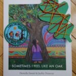 Click here for more information or to register Hosting Club: Toronto
Category: Car Hike
Location (Google Maps): We will meet at the Silver Creek Outdoor Education parking lot (coordinates are 43.692615, -79.968433). Hike Leader(s): Monica Pasquali Click here to contact Hike Leader(s) Pace: Leisurely (2-3 km/hr)
Terrain: Level 2 (Intermediate – some hills and uneven surfaces, rocks and roots underfoot)
Distance (km): 3 km Description
Celebrate the end of summer and the beginning of fall by participating in a family-friendly “Passport to Nature” event along the Bruce Trail! We will begin our adventure by reading the storybook “Sometimes I Feel Like an Oak” by Canadian Indigenous author Danielle Daniel. We will talk about the different trees mentioned in the book, including how they can be identified, so we can find some of them as we complete a 3 km loop hike of the main Bruce Trail and Roberts Side Trail. We will then finish our day together by enjoying our snacks and doing a tree-themed art activity outdoors before we all head home. The hike leader will bring the storybook and art supplies as well as a first aid kit and FREE Toronto Bruce Trail Club Youth Badges for children aged 13 and under who participate in the day’s activities. Participants should bring something to sit on (e.g., folding chair, picnic blanket, etc.) to be used before and after the hike which can be stored in the car during the hike. Participants should also bring their own water and nut-free snacks. Please note that children should be accompanied by an adult, and all participating children and adults should register for this hike. The 3 km loop hike will be hiked at a leisurely pace so it will take us approximately 1.5 hours to complete. The trail is rocky and hilly in places and is therefore not stroller-friendly so all participants should be capable of walking on their own. Please wear clothing appropriate for the weather and comfortable shoes with good traction.
| 21 - Multi-day Trip to Manitoulin Island
12:00 AM 09/21/2026 https://hikes.brucetrail.org/event/multi-day-trip-to-manitoulin-island/2026-09-21/ 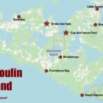 Hike open to BTC Members only. This is a Multi-Day HikeYou are signing up for the following dates and times:
2026-09-21 at
2026-09-22 at
2026-09-23 at
2026-09-24 at
2026-09-25 at Click here for more information or to register Hosting Club: Iroquoia, Peninsula
Category: Special Event
Location (Google Maps): Manitoulin Island
Registered participants will receive a WhatsApp invitation (optional) which can be used for photo share. Hike Leader(s): Ruth Moffatt Click here to contact Hike Leader(s) Pace: Leisurely – 3km/hr or less, Medium – 3 to 4 km/hr
Terrain: Dependent on Conditions, Moderate – Some hills and/or some poor footing, Strenuous – Hilly with steep climbs and some poor footing
Distance: Varies Description
Everyone who is registered for this hike series will be invited to join an optional WhatsApp which can be used to share photos and other information. Please join Beth Gilhespy and Ruth Moffatt for a 5 day/4 night trip over to Manitoulin Island (Manidoo Minising) where we will hike and explore the Escarpment Biosphere Conservancy (EBC) trails. Manitoulin Island is the world’s largest freshwater island and is known for its stunning nature, Indigenous culture (home to six Anishinaabe First Nations), and outdoor activities. We will access it via MS Chi-Cheemaun ferry from Tobermory. Shared expenses for accommodation with whomever you are sharing your cabin with and travel (gas, ferry expenses). Breakfast and lunch will be your own responsibility. Shared dinners TBA.
Day1 – Mon, Sept 21, 2026 – 9am – meet in the BTC Parking Area on the east side of the road – 2461 Bruce County Rd 9, Barrow Bay. Depart at 9:15am in two vehicles. You can leave your car here if you are comfortable doing so or get dropped off.
On the way up to Tobermory to catch the MS Chi-Cheemaun ferry, we will stop at the EBC’s Alvar Bay Nature Preserve (close to Tobermory). We should be in position for the ferry at 11:30am so you will have time for your lunch in the Tobermory area. We will proceed to catch the TBA 1:15pm ferry crossing. The ferry crossing takes about 1.75 – 2 hours. From the arrival in South Baymouth we will proceed to Mindemoya Court Cottages and Campground (about 35 min) https://mindemoya.ca/cottages. Please arrange your reservation with Kim at enquiries@mindemoya.ca Let her know that you are with the Bruce Trail group. You may book any cottage or trailer you like. Waterfront 15T and 16T are being held for us until February 15. Check in is September 21 (Check in time is 3pm)and check out is Sept 25 (check out time is 9am). There is tent camping as well, if you prefer.
This location is very close to the town of Mindemoya where there are amenities if needed.
Please make note of what you will need to bring to the cottages. The cottages are located on Mindemoya Lake so we should have some nice sunsets/stargazing opportunities. This is our tentative hiking schedule which is subject to change.
Day 2 – Tues, Sept 22, 2026 – After breakfast we will hike EBC Cup and Saucer Nature Preserve 12km
Day 3 – Wed, Sept 23, 2026 – After breakfast we will hike EBC Lake Wolsey Nature Preserve 7km and then go visit Bridal Veil Falls.
Day 4 – Thurs, Sept 24, 2026 – After breakfsast we will hike EBC East Bluff Nature Preserve and possibly nearby EBC Barrie Island Nature Preserve 8.5km, if enough time.
Day 5 – Fri, Sept 25, 2026 – After breakfast and check out of cottages by 9am we’ll hike EBC Fossil Hill Nature Preserve 6km/Dominion Bay. Drive to South Baymouth to catch the TBA 3:50 pm ferry, arriving Tobermory TBA 5:50 pm Badges will be available for some of the trails we visit. Please visit https://escarpment.ca for information about the Escarpment Biosphere Conservancy and EBC Hiking Trails of Manitoulin Island (Manidoo Minising). It may be helpful to book your accommodations first and then complete your registration. We’d like to keep the group to 20 people maximum.
| 22 - Long Hike Short Hills
8:00 AM-10:30 AM 09/22/2026 https://hikes.brucetrail.org/event/long-hike-short-hills-12/2026-09-22/ Click here for more information or to register Hosting Club: Niagara Location (Google Maps): Short Hills Wiley Road, Thorold Hike Leader(s): Alan Laver Pace: Brisk 4-5 km/hr
Terrain: Moderate: some hills and some poor footing
: 10k+ Description
Our regular Spot for the Tuesday Long Hike. Note the new location. We will hike the trails around Short Hills Dress for the weather and bring sunscreen bug spray, poles snack and drink
| 23 | 24 - 8:00 am Long hike NEW Location. Bailey bridge Jordan
8:00 AM-10:30 AM 09/24/2026 https://hikes.brucetrail.org/event/800-am-long-hike-new-location-bailey-bridge-jordan-13/2026-09-24/ Click here for more information or to register Hosting Club: Niagara Location (Google Maps): Bailey bridge Jordan Hike Leader(s): Alan Laver Pace: Brisk 4-5 km/hr
Terrain: Strenuous: hilly, with steep climbs, poor footing
: ~10k Description
This will be our permanent location . Hike up from the Bailey bridge to Balls Falls and explore the trails You must register for each hike. Bring Poles, snack and a drink. Dress for the weather
- Toronto Fall Series Hike 4 of 9
9:30 AM-2:30 PM 09/24/2026 https://hikes.brucetrail.org/event/toronto-fall-series-hike-4-of-9/2026-09-24/ Click here for more information or to register Hosting Club: Caledon Hills
Category: End-to-End
Location (Google Maps): Meet at the roadside parking on Eighth Line, where the Eighth Line Side Trail is. Map 13 east of km 33.5. Hike Leader(s): Nancy Mooney Click here to contact Hike Leader(s) Pace: Medium – 3 to 4 km/hour
Terrain: Moderate – some hills and/or some poor footing, Strenuous – hilly with steep climbs and some poor footing
Distance: 14 km loop Description
This is the fourth hike in the series. We will continue around the Scotsdale Farm and Silvercreek area including Duff Pit, Trafalgar, Reservoir, Great Esker, and Eighth Line Side Trails. Copper Kettle post hike!
| 25 - Coach Trip: Saugeen Peninsula Hiking Weekend
7:00 AM-8:00 PM 09/25/2026 https://hikes.brucetrail.org/event/coach-trip-sept-25-to-27-saugeen-peninsula-hiking-weekend/2026-09-25/ Trip Information
Departure Time: 07:00
Return to City Time: 20:00
Departure Point: York Mills Bus Pickup Click here for more information or to register Trip Activities
Moderate group ($0.01)
Fast group ($0.01)
Optional Items
Pickup at HWY 400 and Major Mac ($0.01)
Hosting Club: Toronto
Category: Coach Trips
Location (Google Maps): Evergreen Resort, Red Bay Hike Leader(s): Martina Furrer, Janet McColeman, Robin Crombie, Tim Wainwright Click here to contact Hike Leader(s) Pace: Brisk (4-5 km/hr), Moderate (3-4 km/hr)
Terrain: Challenging, Hilly, Level 2 (Intermediate – some hills and uneven surfaces, rocks and roots underfoot), Rocky
Distance (km): Moderate 12km, Fast 15 to 18 km Description
Departure: Friday September 25 - 7AM from 10 York Mills Rd
- 7:20 AM from HWY 400 and Major Mackenzie Dr Park and Ride
Return: Sunday September 27 between 7 and 8 PM Join us for three days of guided hiking on the beautiful Saugeen Peninsula. Spend your days on the Bruce Trail and your evenings at Evergreen Resort (https://evergreenresortredbay.com/index.html) overlooking Lake Huron. We will explore the Skinner’s Bluff, Colpoy’s Bay, Cape Crocker, Hope Bay, Rush Cove, Barrow Bay, Lion’s Head, and/or Cape Chin areas, using both the main trail and some fun side trails. You will be treated to scenic lunch spots, cool dolostone cliffs, neat crevasses, beautiful shale beaches, and lots of awesome views of Georgian Bay. Come prepared for some strenuous climbs, some challenging footing over boulders and crevasses, and some exposed sections. There will be a moderate group (hiking about 12 km each day) and a fast group (hiking between 15 and 18 km each day). Both groups will do full day hikes with no dropouts. Please note the Peninsula section is rugged. These hikes are not suitable for people who are afraid of heights. All fit, experienced hikers comfortable walking on this type or terrain are welcome. There won’t be a sightseeing group or other activities for non-hikers. Accommodation is in one-, two-, and three-bedroom cottages (linens, bedding, and towels provided). Each cottage has a full bathroom, fridge, and heater. The resort has a hot tub and a private beach perfect for viewing sunsets. Cost is $370.75 per person (plus taxes and gratuity extra). This includes two nights’ accommodation, two dinners, two breakfasts, and two boxed lunches. Another group will be at Evergreen Resort the same weekend as us. To ensure there is space for all participants and we can run this trip, all cottages must be shared, all bedrooms in all cottages must be occupied, and some bedrooms will need to be shared. The one-bedroom water view cottages have a sitting area with a small table, two chairs, and a couch, a three piece bathroom, and a bedroom with two double beds. Each one-bedroom cottage needs to be occupied by two people. Similarly each garden view motel unit has two double beds and a sitting area. These units will also need to be shared. Finally each two-bedroom cottage will need to have three occupants. The only units suitable for single occupancy are garden view units 203 and 204 (they are small with no sitting area). Coach fare is $195 for members, $215 for non-members, and $120 for children. All applicable fuel surcharges as of June have been included in the coach fare. In these volatile times the Toronto Bruce Trail Club reserves the right to charge for currently unanticipated increases in the cost of fuel. Registration instructions: Please find roommates / cottagemates before you register. To avoid problems, make sure you and your roommate(s) reserve your cottage and your seats on the coach at the same time. If you’re new to our coach trips or don’t have a friend who would like to join you, complete our roommate request form at: https://saugeen.s.gy/rooms and we will do our best to find you a match. - Call Evergreen Resort at 519-534-1868 to book your cottage.
- To reserve your seat on the bus, register here starting on Friday June 12th at 8:00 PM.
Cancellation policy: While we are hoping for sunshine, the trip cannot be cancelled due to weather. Coach fare is non-refundable.
- Niagara-on-the-Lake Tour
9:00 AM-10:30 AM 09/25/2026 https://hikes.brucetrail.org/event/niagara-on-the-lake-tour-64/2026-09-25/  Click here for more information or to register Hosting Club: Niagara
Category: Urban
Location (Google Maps): Park on King St near Centre St, just outside of Veteran’s Memorial Park, Niagara-on-the-Lake Hike Leader(s): Margaret Northfield Click here to contact Hike Leader(s) Pace: Medium 3- 4 km/hr
Terrain: Easy: mostly flat, good footing
Distance: 6-7km Description
Each Friday we will explore Niagara-on-the-Lake while getting a moderate paced walk. Discover where the Niagara River meets Lake Ontario. Experience the Heritage District, woods and the Niagara Parkway. Some weeks may be totally on sidewalks and roads while others may include a mix of trail and paved pathways. Great way to build up endurance for longer more strenuous hikes. Plan to stay for conversation and a coffee at Sweets & Swirls, Community Centre, Niagara Stone Rd., NOTL
| 26 - Blue Mountains Six Pack
8:30 AM-3:00 AM 09/26/2026 https://hikes.brucetrail.org/event/blue-mountains-six-pack/2026-09-26/ - Car Hike: Rouge Park
8:30 AM-1:15 PM 09/26/2026 https://hikes.brucetrail.org/event/car-hike-rouge-national-park-scarborough-on-5/2026-09-26/ Click here for more information or to register Hosting Club: Toronto Location (Google Maps): Free parking in mast trail parking Lot off Kingston Road Hike Leader(s): MOHAMMAD AGHAMIRI Click here to contact Hike Leader(s) Pace: Moderate (3-4 km/hr)
Terrain: Hilly, Level 2 (Intermediate – some hills and uneven surfaces, rocks and roots underfoot)
Distance (km): 12-14 km Description
We will hike Vista trail and part of orchard trail, will enjoy look outs between Rouge river and Little Rouge creek
• Please dress appropriately for the weather.
• We will have short water ,picture and a 15 minute snack break. Everyone is welcome! Please bring lots of water and snacks ,hiking poles are recommended phone number for the day of hike 289 588 6482
 Geology Hike at Rock Hill Park Geology Hike at Rock Hill Park 9:30 AM-12:00 PM 09/26/2026 https://hikes.brucetrail.org/event/geology-hike-at-rock-hill-park/2026-09-26/ 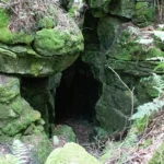 Click here for more information or to register Hosting Club: Dufferin Hi-Land
Category: General Hike
Location (Google Maps): Rock Hill Park Side Trail parking lot (1st LIne N, Mulmur at km 30.5) Hike Leader(s): Lynda Bloom Click here to contact Hike Leader(s) Pace: Leisurely
Terrain: Moderate
Distance: 7 km Description
Join geologist Lynda Bloom and hike leader Julie Daley for an unforgettable trek through Rock Hill Park. You’ll explore stunning limestone caverns carved by ancient glaciers, wander through cool rock crevices lined with ferns and mosses, and discover the area’s rich history—including the remains of old lime kilns once vital to local farming. Along the way, enjoy stories about the park’s surprising past, including the rock concerts that took place here in the 1960s.
 RAINBOW HIKE: Crawford Lake—Boardwalk, Geology & Indigenous History RAINBOW HIKE: Crawford Lake—Boardwalk, Geology & Indigenous History 9:30 AM-2:00 PM 09/26/2026 https://hikes.brucetrail.org/event/rainbow-hike-crawford-lake-boardwalk-geology-indigenous-history/2026-09-26/ 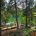 Click here for more information or to register Hosting Club: Iroquoia
Category: Rainbow Hike
Location (Google Maps): Crawford Lake Conservation Area, 3115 Conservation Rd, Milton Hike Leader(s): Doug O’Neill Click here to contact Hike Leader(s) Pace: Leisurely – 3km/hr or less, Medium – 3 to 4 km/hr
Terrain: Easy – Mostly flat and usually good footing, Moderate – Some hills and/or some poor footing
Distance: 12 km approx Description
On this all-inclusive 2SLGBTQIA+ Rainbow hike, we’ll explore one of the gems along the Bruce Trail: Crawford Lake, and potentially Rattlesnake Point. Expect a day of Indigenous history, geology, stunning scenery—and the September reopening of the boardwalk around Crawford Lake. The hike: We’ll follow a mix of the Nassagaweya Canyon Trail/Bruce Trail, as well as the Woodland, Escarpment and Pine Ridge trails. We’ll allow time to visit the reconstructed longhouses, representing a 15th-century Wendat/Iroquoian village, and any exhibits at the nature centre. Note: If the reopening of the boardwalk is delayed, we’ll extend the hiking component. Getting there: This hike involves a carpool from Burlington GO Station. If you don’t have access to a car—no worries. Take public transit to Burlington GO Station, and we’ll divide into as few cars as possible for the 25-minute drive to the Crawford Lake parking lot. Meet-up: We’ll rendezvous at the Burlington GO parking lot at 9 a.m. for a 9:15 a.m. departure. Meet at the east door on the south side. If you’re coming by GO TRAIN, go to the south/Fairview exit. I’ll be at the east entrance. Conservation Centre admission fee: $10.50 per person. I have a Halton Conservation Membership and can cover one vehicle with up to five passengers. Drivers should not pay; passengers can chip in a few dollars for the driver. By Public Transit to Burlington GO Meet-Up: Take the eastbound GO Train from West Harbour GO (James Street North & Murray Street East—across from LIUNA Station) (NOT Hamilton GO Centre on Hunter Street). Exit at Burlington GO and head to the parking lot. Please arrive by 9 a.m. Bring sufficient water (1 L minimum), lunch and energising snacks. Wear hiking boots or sturdy shoes. Avoid shorts during tick season. Bring a hat, sunblock and insect repellent. Get your complimentary Bruce Trail Rainbow badge! Feel free to reach out to the Hike Leader if you have any questions “Click here to contact Hike Leader” on this form.
- International Friendship Trail – Cape Chin Meadows Sidetrail
9:30 AM 09/26/2026 https://hikes.brucetrail.org/event/international-friendship-trail-cape-chin-meadows-sidetrail/2026-09-26/  Click here for more information or to register Hosting Club: Peninsula Location (Google Maps): Maple Cross Nature Reserve at Cape Chin, 388 Cape Chin Road North, Lion’s Head Hike Leader(s): Owen and Marg Glendon Click here to contact Hike Leader(s) Pace: Medium (3.0 – 4.5 km/h): A comfortable pace for most hikers with steady progress.
Terrain: Moderate: Rolling hills, mild slopes and rocky paths.
Distance: 10.5 km Description
The Bruce Trail Conservancy is a founding member of the World Trails Network, working collaboratively to promote and support public footpaths through the creation of Friendship Trails.Much like twin cities, Friendship Trails connect trail organizations from different countries in a spirit of partnership, shared promotion, and international collaboration. These connections celebrate friendship, strengthen community, and bring people from all walks of life together both with nature and with one another. Bruce Trail Conservancy features 10 Friendship Trails at different BTC Club locations. PBTC has the privilege of hosting two Friendship Trails, The Cotswold Way and Southwest Coastal Path, in Great Britain. You can read more about BTC Friendship Trails here: https://brucetrail.org/International-friendship-trails/ This is the last of the Friendship Hike mini-series. The South West Coast Path, the longest established National Trail in the UK. Known for its spectacular coastal views, rocky cliffs, and diverse flora, it pairs beautifully with the Cape Chin Meadows Side Trail, in the Peninsula section, which boasts similar features along Georgian Bay. Learn more about SWCP here: https://www.southwestcoastpath.org.uk/ Our 10 ½ km loop hike takes us along a wetland, through mixed forest over mostly flat but rocky terrain. This will be a medium paced hike with time for lunch at one of the most beautiful lookouts on the entire Bruce Trail. Plan for ~ 4 hour hike which includes a stop at noon. Brad and Sara McMillan, PBTC Trail Captains and SWCP hikers, will join our hike today. Together, we will share some of our wonderful hiking experience on the Southwest Coastal Path. Have you hiked the Southwest Coastal Path. Join the hike and share your story! Let’s celebrate trails around the world and be inspired to travel to one of the International Friendship Trails.
 Peninsula Harvest Full Moon Hike – Meet time is 6pm Peninsula Harvest Full Moon Hike – Meet time is 6pm 6:15 PM-8:45 PM 09/26/2026 https://hikes.brucetrail.org/event/peninsula-harvest-full-moon-hike-meet-time-is-6pm/2026-09-26/  Click here for more information or to register Hosting Club: Iroquoia, Peninsula
Category: Moonlight Hikes
Location (Google Maps): Lion’s Head – Park near the Lion’s Head Municipal Campground entrance on Phillip Forbes St Hike Leader(s): Ruth Moffatt Click here to contact Hike Leader(s) Pace: Leisurely – 3km/hr or less, Medium – 3 to 4 km/hr
Terrain: Dependent on Conditions, Easy – Mostly flat and usually good footing, Moderate – Some hills and/or some poor footing
Distance: 11km Description
This full moon hike is in the Peninsula Section of trail and led by an Iroquoia Hike Leader. Welcome to the 4th Full Moon Hike Series led this summer. Details for collecting badges are at the bottom of the hike details.
We will meet under the tall pine trees just outside the entrance to Lion’s Head Municipal Campground. Our hike will take us out to Lion’s Head Point and return. Since some of our hike is on road, please wear a hi-vis vest if you have one. I will have a few to distribute as well. Sunset is at 7:16 – Harvest Moon
We are getting started early due to the distance and nature of the hike. Bring water and whatever snacks you need as well as a first aid kit, poles if you use them and most importantly, a head-lamp with a red light if you have one. The following is from the Bruce Trail Conservancy website regarding Hiking at Night.
While most hikers choose to explore the Bruce Trail by day to take in the colourful sights and vast vistas, venturing out after dark also has its benefits.
Hiking at night allows you to tap into other senses and explore nature in a whole new way. From stargazing to nocturnal animal sightings, there is a lot to see and hear when exploring the Bruce Trail after sunset. No matter your motivation for heading out for a nighttime hike, certain precautions should be taken to ensure that your time on the Trail is safe and enjoyable. Before you go
Plan your route and choose somewhere familiar. It’s easy to get turned around in the darkness. Planning your route and hiking it in daylight first will help you know what to expect. If you’ve never tried hiking at night, start with a shorter hike somewhere familiar to you. Always stay on the Trail to avoid getting lost. Bring a headlamp or flashlight and extra batteries. The Trail can be quite rugged with uneven surfaces, rocks, and roots. A headlamp or flashlight is essential for preventing trips and falls – and both are brighter and last longer than your phone’s built-in light. A light source with different settings, including a red light, is ideal as bright lights can be hard on your eyes over time. Bring a fully charged cell phone. You should always bring your phone with you when hitting the trails in case you need to call for help. Most phones have a flashlight function that can act as a backup to your headlamp. You can also use your phone’s GPS with apps like the Bruce Trail App and what3words for navigational and safety purposes. Wear reflective clothing and bring a whistle. A reflective piece of clothing can help other hikers or drivers see you in the darkness. A whistle can help others hear you in case of an emergency, even if they can’t see you. Plan to do your first hike under a full moon and a clear sky.
A full moon can provide a surprising amount of light. Planning your first night hike during a full moon and clear sky can be a great way to acclimate yourself to hiking after dark. Don’t go solo and tell someone where you are going. Always share your route with someone before heading out in case of an emergency. Bring a friend to explore the Trail together, or join one of the moonlit hikes offered by some Bruce Trail Clubs. Bring layers. The temperature can drop quickly in the woods at night. Bring layers to stay warm and comfortable.
While Hiking Slow down and be aware of hazards. Don’t expect to hike at the same pace you would in daylight. Darkness can make the terrain more challenging. Slow down, pay attention to your surroundings, and stay away from cliff edges to prevent injuries. Be prepared for wildlife. Many animals such as coyotes, owls, bats, salamanders, foxes, opossums, and skunks are active at night. Sightings can enhance your nighttime hiking experience but be careful not to get too close. Keep your ears open to the sounds around you to avoid unwanted interactions. While more preparations may be needed for a hike after dusk, for many, once they find themselves in the cool of the night gazing up at the constellations or watching an owl swoop through the darkness, the effort is well worth it. If you are collecting your badge tonight please bring exact cash $10 for members and $15 for non-members to cover the cost of the badge. You must’ve have completed at least 4 full moon hikes. If you wish to pay by e-transfer and have your badge mailed out to you, you may also choose to receive it that way. For simplicity sake, and because it will be dark out, it would be appreciated if you could please choose one method of receiving your badge or the other. Badges are on the honour system so if this is your 4th hike, please feel free to receive your badge.
|
27 - Caledon Hills E2E In 4 Hike #2
8:15 AM-2:30 PM 09/27/2026 https://hikes.brucetrail.org/event/caledon-hills-e2e-in-4-hike-2-2/2026-09-27/  Click here for more information or to register Hosting Club: Caledon Hills
Category: End-to-End
Location (Google Maps): Roadside Parking – km 35.0 on Coolihans Sideroad, east of where the trail crosses the road. Hike Leader(s): Dan Patterson Click here to contact Hike Leader(s) Pace: Medium – 3 to 4 km/hour
Terrain: Strenuous – hilly with steep climbs and some poor footing
Distance: 16.7 km Description
Welcome to Caledon Hills In 4 Fall Edition. Meet at Coolihans Side Road where the Bruce Trail crosses the road at 8:15 a.m. We will shuttle to 5th Line EHS & Hockley Rd. Bruce Trail Parking to start the hike. This is an End-to-End series to complete the Caledon Hills section of the Bruce Trail in 4 hikes. We will be hiking from the north end to the south end. Join for as many hikes as desired – you will need to register for each hike in the series which will take place on the following dates: Sept. 20 & 27, Oct. 18 & 25. Since this is a group hike, please consider your fitness level before registering. We will be walking at a pace of 3 km – 4 km per hour and hikers will need to keep up with the person in front of them for the duration of the hike. The hike series will also involve car shuttles and every hiker is expected to participate as drivers. Weather conditions can be variable, dressing in layers is recommended. Hiking boots are required and hiking poles are strongly recommended. Bring plenty of fluids, electrolytes. lunch and snacks. This section is challenging with many hills.
| 28 | 29 - Mono Centre: Turnbull, Springwater, Third Outlier and Whitetail Refuge Side Trails
9:30 AM-12:00 PM 09/29/2026 https://hikes.brucetrail.org/event/mono-centre-turnbull-springwater-third-outlier-and-whitetail-refuge-side-trails-3/2026-09-29/ Click here for more information or to register Hosting Club: Dufferin Hi-Land
Category: Tuesday Hike
Location (Google Maps): Caledon Hills Section, Map 19. Meet at Mono Community Centre hiker parking area (near Km 72.4). Hike Leader(s): Les Babbage, Inge Eckerich, Julie Daley, Tony Evangelista Click here to contact Hike Leader(s) Pace: Leisurely
Terrain: Slippery and Steep Sections, Moderate
Distance: 6.0 Km, Short hike 3.5 km Description
We will hike the Main Trail to Turnbull and Springwater Side Trails. The short hike will return to the parking lot by Main Trail. The longer hike will continue south on Main Trail to the Third Outlier Side Trail, connecting to the Whitetail Refuge Side Trail and returning to parking by way of the Laidlaw Side Trail. Bring water and snacks.
| 30 -
 Peninsula E2E in a Fall – 8 days hike through +1 mid rest day Peninsula E2E in a Fall – 8 days hike through +1 mid rest day 8:00 AM-4:00 PM 09/30/2026 https://hikes.brucetrail.org/event/peninsula-e2e-in-a-fall-8-days-hike-through-1-mid-rest-day/2026-09-30/ 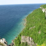 This is a Multi-Day HikeYou are signing up for the following dates and times:
2026-09-30 at 08:00
2026-10-01 at
2026-10-02 at
2026-10-03 at
2026-10-04 at
2026-10-05 at
2026-10-06 at
2026-10-07 at
2026-10-08 at Click here for more information or to register Hosting Club: Iroquoia, Peninsula
Category: Stained Glass Badge End to End Fundraiser Hike
Location (Google Maps): -Meeting point on Sept 30th – at Bluewater Park, Wiarton, parking area opposite arena – First Hike only – Schedule with coordinates will be sent for remaining hikes to registered hikers
First hike : meeting time is 8.00 am Wiarton to shuttle to our trail head where we will start the hike. Hike Leader(s): Corina Seceleanu Click here to contact Hike Leader(s) Pace: Medium – 3 to 4 km/hr
Terrain: Strenuous – Hilly with steep climbs and some poor footing
Distance: 167.5 Km Description
Category: Peninsula E2E– Sept 30th to Oct 8th 2026 This is moderate hike that we will complete the entire 167.5 km of the Peninsula section in 8 hikes; the entire trip constitutes of 9 days with one rest day in between. It is also a Paid hike; your registration fee includes a celebratory finish at the Cairn in Tobermory, the cost of the End-to-End badge, and contributes to fundraising for the Peninsula Bruce Trail Club hiking program activities. Please review the dates carefully to ensure you are able to participate fully. Registration is limited to 10 persons. - This hike series is intended for experienced distance hikers. Hikers must be able to sustain the distance and maintain the pace as advertised.
- Be very aware of your ability to join this series.
- Hikes will average 3.5 km per hour including breaks, moving pace is 3.5 to 4 km per hour;
- Expect to be on-trail for min 7.5 to 8h sometime longer depending on the distance, terrain, weather and group pace; The hike leader set the pace, aiming for the 3-4 Km/h and may adjust as needed for the group ability and trail conditions
- Meeting time: 7:45 am every day, (except first day) at designated location (to be provided basis on the schedule).
- Please arrive no later than 15 minutes prior to the meeting time;
- Hikers must carry sufficient hydration, accessible snacks, lunch, first-aid kit, rain gear, extra socks, and possibly protective boot covers (i.e. bags), also hiking poles recommended.
- Hikers will be expected to participate in shuttling hikers to the start and to drive shuttlers back to their car. Responsibility for shuttling along with any applicable parking fees will be shared within the group.
Summary of the itinerary (km based on Bruce Trail Reference – Edition 31): 1: Sep 30 (Wednesday): Rd Side parking on Coveney’s Rd to Wiarton Bluewater Park – 21.5 km 2: Oct 1 (Thursday): Rd. Side Parking at South End of Cathedral Dr. to Rd Side parking on Coveney’s Rd – 26.15 km 3: Oct 2 (Friday): Cemetery Rd Side trail parking to Rd Side parking at South End of Cathedral Dr. – 21.10 km 4: Oct 3 (Saturday): (2 parts to defer Isthmus Bay Rd. walking, which would be made on last day) - Part 1 – Cemetery Rd. side trail parking to Lion’s Head lookout parking /or in the city) – 11.84 km
- Part 2 – Richardson Side Trail parking to Cape Chin South Rd – 11.34 km —— total 23.48 km
5: Oct 4 (Sunday): Rest Day – No hikes 6: Oct 5 (Monday): Cape Chin South Rd. parking at Carter Rd to Lindsay Rd . &Gilles Lake – 21.90 km 7: Oct 6 (Tuesday): Lindsay Rd. & Gilles Lake to Halfway Dump Side Trail (parking lot) – 22.83 km 8: Oct 7 (Wednesday): Little Cove Parking lot to Halfway Dump Side Trail (parking lot) – 17.73 km 9: Oct 8 (Thursday): 2 parts - Morning/Lunch – Little Cove parking to Tobermory Cairn – 6.70 km — badge ceremony
- Lunch /Afternoon – before going home make up the Isthmus Bay Rd (from town of Lions Head /Lion’s Head lookout parking to Richardson Side Trail Parking lot – 6.25Km—total 12.95 Km
For safety, participants must remain between the hike leader and the hike sweep at all times. Transportation & Accommodations: - Car shuttle: Participants rotate as drivers; vehicles must be passenger-ready- in each day.
- Accommodations: Book early; options include motels, campgrounds, hostels, and B&Bs from Wiarton to Tobermory
Note: A detailed schedule will be provided in advance of the series to registered hikers.
If you have concerns, or questions please use the Contact Hike Leader form to inquire in advance of registering.
Dogs are not permitted More details will be provided at later date to those registered for the hike.
| October | October | October |