Access to the Hike Schedule is currently unavailable for logged in users. We are working to resolve the issue and apologize for the inconvenience.
Hike Schedule
Join us for a hike! Registration required:
All hikes available to BTC members. Some hikes are open to non-members.
TIP: The calendar view displays up to 7 hikes on a day, but often there are more. Click “More events” to see them all.
Niagara
Iroquoia
Toronto
Caledon Hills
Dufferin Hi-Land
Blue Mountains
Beaver Valley
Sydenham
Peninsula
All Clubs
Show Filters
Categories
Reset Filters
- 02August 2, 2026
Burlington Heritage Week / River & Ruin Historical Hike
https://hikes.brucetrail.org/event/burlington-heritage-week-river-ruin-historical-hike/
Registration Required:
Click here to register for this hike (25 spots remaining)Hosting Club: Iroquoia
Category: Historical Hike
Location (Google Maps): Kilbride Park Parking Lot Behind the Kilbride School, access to Main Trail and Kilbride PassHike Leader(s): Joe Borges Click here to contact Hike Leader(s)
Pace: Leisurely – 3km/hr or less
Terrain: Dependent on Conditions, Moderate – Some hills and/or some poor footing, Slippery and Steep Sections
Distance: 7.6 kmDescription
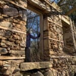
Burlington Heritage Week Hike: River & RuinJoin us for the special hike brought to you by Iroquoia Bruce Trail Club partnering with the City of Burlington for Heritage Week.
The theme this year is water, so we will hike through one of Burlington’s most historically rich landscapes. The River & Ruin trail winds through the beautiful Lowville Valley, where the natural drama of Twelve Mile Creek meets the traces of Burlington’s early settlement history. Along the way, we’ll explore the stories of Kilbride, Lowville, and the Cleaver family, whose mill, homestead, and ruins helped shape this valley nearly two hundred ago.
This hike offers more than beautiful views, it’s a walk through time. From the limestone ruins and historic mill site to the creek that powered early industry and settlement, the route reveals how farming, waterpower, and pioneering families transformed the area into one of Burlington’s most fascinating heritage corridors. If you enjoy trails with a strong sense of place, local history, and a great story under your boots, this is the hike for you.
Come discover the hidden history of Kilbride and the Lowville Valley, experience why this unique trail is one of Burlington’s most memorable heritage walks.
Note, no dogs are permitted on this hike.
- 05August 5, 2026
Evening Hike in Owen Sound followed by Social Time at the Hike Leader`s home
https://hikes.brucetrail.org/event/evening-hike-in-owen-sound-followed-by-social-time-at-the-hike-leaders-home/
Registration Required:
Click here to register for this hike (98 spots remaining)Hosting Club: Sydenham
Category: Hike & Potluck
Location (Google Maps): Meet in the municipal parking lot by the river on the West side of 1st Ave East between 7th St East an 8th St East in Owen SoundHike Leader(s): Harriet Nixon Click here to contact Hike Leader(s)
Pace: Brisk: 4 to 5 km/h
Terrain: Moderate: Some hills and/or poor footing
Distance: Approx 5 kmDescription
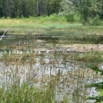
Join us for a brisk summer evening hike exploring the Sydenham River valley within the Owen Sound City limits. Following the hike participants are invited to the Hike Leader`s home for refreshments. There is no need to show up 15 minutes early for this hike, but we will leave promptly at 7:00 pm. - 06August 6, 2026
Beaver Bites - Hike 1 of 4
https://hikes.brucetrail.org/event/beaver-bites-hike-1-of-4/
REGISTRATION FULL: This hike has reached the maximum number of hikers.
Click here to be added to the Wait List.Hosting Club: Caledon Hills
Category: General
Location (Google Maps): Meet at Epping Lookout, km 94.3, on Grey Road 7 north of 19 Sideroad.Hike Leader(s): Nancy Mooney Click here to contact Hike Leader(s)
Pace: Medium – 3 to 4 km/hour
Terrain: Moderate – some hills and/or some poor footing
Distance: There are 2 hikes on this day and each of the 4 days in this series. The first hike will be 9.8 km and the second hike will be 3.8 km.Description
This hike series involves long days but a great way to tackle 30 km of side trails in Beaver Valley to earn the Beaver Bites badge. We will loop around Fairmount with a break at Webwood Falls. (Map 28) We will then have a lunch break back at Epping Lookout, including the short Epping Side Trail before heading over to do a short loop at the Wodehouse Management area and the Sligo Side Trail. (Map 27) - 08August 8, 2026
Peninsula Sunrise Series: The Grotto
https://hikes.brucetrail.org/event/peninsula-sunrise-series-the-grotto-2/
Registration Required:
Click here to register for this hike (1 spots remaining)Hosting Club: Peninsula
Category: Sunrise Hike
Location (Google Maps): Parking lot at Dyers Bay Rd & Hwy 6, Northern Bruce Peninsula, ON N0H 1Z0Hike Leader(s): Kathleen Stahlbaum Click here to contact Hike Leader(s)
Pace: Leisurely (2.0 – 3.0 km/h): A relaxed pace with frequent breaks and a focus on enjoyment., Medium (3.0 – 4.5 km/h): A comfortable pace for most hikers with steady progress.
Terrain: Difficult: Steep ascents/descents, rocky scrambling, and some rugged escarpment paths., Easy: Flat forested sections or lowland trails., Moderate: Rolling hills, mild slopes and rocky paths.
Distance: 7.5 kmDescription
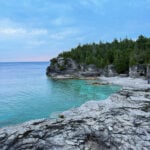
Experience the magic of dawn on the Bruce Trail with the Sunrise Hike Series offered by the Peninsula Bruce Trail Club. These early morning hikes provide a perfect opportunity to awaken your senses, boost your energy, and immerse yourself in the tranquility of nature as the sun paints the sky with breathtaking hues. As we make our way through scenic forest trails, we’ll pause to witness the first light shimmering on the turquoise waters of Georgian Bay – a sight that will surely leave you in awe!Beyond the beauty, morning light helps regulate your circadian rhythm, elevating your mood, boosting energy levels and improving sleep quality. Whether you’re looking to start your day with a sense of calm, capture stunning sunrise photos, or simply reconnect with nature, these hikes offer a unique and inspiring way to greet the day.
On Saturday August 8th, join us in hiking the Cyprus Lake and Georgian Bay Trail to the Grotto at Indian Head Cove, where we’ll experience the sun rising over the Bay from the iconic shoreline before returning via the Marr Lake Trail. We’ll have the joy of taking in the stunning colours of the sky as the first light sparkles on the stunning turquoise waters. This peaceful sunrise hike is the perfect way to connect with nature, capture some incredible photos, and start the day with fresh air and inspiration. Whether you’re a morning person or just love a good adventure, come experience the magic of dawn from one of the best vantage points on the Bruce Peninsula!
Don’t forget to bring a headlamp or flashlight (preferably with a red light setting) as we begin our adventure in the pre-dawn quiet. Join us and discover how a sunrise hike can nourish your mind, body, and spirit – setting the tone for a brighter, more balanced day.
This hike is approximately 7.5 kms in length. Expect to be on the trail for ~3 hours. Pace will be leisurely with ample time to enjoy the sunrise, take some photographs, and nourish yourself!
How to prepare
- Get a good night’s sleep
- Bring lots of water and a snack (breakfast and/or coffee are recommended if that’s your thing!)
- Bring a headlamp or flashlight (preferably with a red light setting)
- Wear waterproof hiking boots
- Hiking poles are recommended but not necessary
- Bring insect repellant or wear protective clothing
- Bring sunscreen
LIMITED SPACE AVAILABLE! We will be meeting at the parking lot at the corner of Highway 6 & Dyer’s Bay road and carpooling in 2-3 vehicles to Bruce Peninsula National Park. If you have a Parks pass, please bring it with you!
In the event of cloudy/rainy weather, the hike will be held on Sunday, August 9th. Please watch your emails for a confirmation the week of the hike!
- 08August 8, 2026

Geology Hike and Badge Series - Lion's Head
https://hikes.brucetrail.org/event/geology-hike-and-badge-series-lions-head/
REGISTRATION FULL: This hike has reached the maximum number of hikers.
Click here to be added to the Wait List.Hosting Club: Peninsula
Category: Geology Hike
Location (Google Maps): Lion’s HeadHike Leader(s): Beth Gilhespy Click here to contact Hike Leader(s)
Pace: Leisurely (2.0 – 3.0 km/h): A relaxed pace with frequent breaks and a focus on enjoyment., Medium (3.0 – 4.5 km/h): A comfortable pace for most hikers with steady progress.
Terrain: Moderate: Rolling hills, mild slopes and rocky paths.
Distance: 11Description
Join the adventure and earn the inaugural Peninsula Geology Badge! Over a stretch of 13 hikes and a couple of extra stops, we will explore the fascinating geology of the Peninsula to learn about the rocks, the shoreline features, glaciation, fossils and all things earthy. The 13 hikes are from the book “Walking Through Time – Exploring the Geology of the Saugeen (Bruce) Peninsula”. Having a copy will give you a lot of great information, but you do not have to purchase the book to attend and enjoy the hikes. Just bring your curiosity! We will make sure to hit all the locations that qualify for the beautiful new Walking Through Time – Saugeen (Bruce) Peninsula geology hike badge. If you would like to purchase a book I will have some available on the hikes, or you can pick one up from the BTC Head Office, at Ginger Press in Owen Sound, Suntrail Source for Adventure in Hepworth, the Shop at 84 Main in Lion’s Head and at Reader’s Haven in Tobermory.You are welcome to come on just a few of the hikes or on all of them, and the dates and hikes are as follows:
Date Geology Hike km
Saturday May 2, 2026 Colpoy’s Bay 9.0
Saturday May 9, 2026 Gravelly Point (am) and Rural Rocks (pm) 8.6
Saturday May 16, 2026 Malcolm Bluff 7.3
Sunday May 17, 2026 White Bluff/Smokey Head 11.8
Sunday May 24, 2026 Crooked Toe Road 5.5
Sunday May 31, 2026 Hope Bay 8.1
Sunday June 14, 2026 Boundary Bluffs 5.2
Saturday July 4, 2026 Cape Dundas 6.2
Saturday July 11, 2026 Beth Gilhespy Side Trail 7.6
Saturday August 8, 2026 Lion’s Head 11.0
Saturday August 15, 2026 Dyer’s Bay Loops 7.5
Saturday August 22, 2026 North Saugeen (Bruce) Shoreline 8.0
Meeting times will vary depending on the hike, but will generally be some time between 9 am and 10 am. Information on exact meeting times and locations will be sent out a few days prior to the hike.
- 13August 13, 2026
Beaver Bites - Hike 2 of 4
https://hikes.brucetrail.org/event/beaver-bites-hike-2-of-4/
REGISTRATION FULL: This hike has reached the maximum number of hikers.
Click here to be added to the Wait List.Hosting Club: Caledon Hills
Category: General
Location (Google Maps): Meet at Metcalfe Crevices parking area, km 27.9, where the main trail crosses 10th Line.Hike Leader(s): Nancy Mooney Click here to contact Hike Leader(s)
Pace: Medium – 3 to 4 km/hour
Terrain: Moderate – some hills and/or some poor footing, Strenuous – hilly with steep climbs and some poor footing
Distance: Hike one will be 10.4 km and the second hike will be 7 km.Description
This day will be challenging but rewarding when we loop through Duncan Crevice Caves Provincial Nature Reserve, (Map 25) and explore Metcalfe Crevice. After our lunch break we will head over to Loree Forest and hike another loop. - 15August 15, 2026
Car Hike: Boyd Conservation Park ,Vaughan
https://hikes.brucetrail.org/event/car-hike-boyd-conservation-park-vaughan-16/
Registration Required:
Click here to register for this hike (25 spots remaining)Hosting Club: Toronto
Location (Google Maps): Free Parking lot before entrance of park on Islington Ave.
Hike Leader(s): Mohammad Aghamiri Click here to contact Hike Leader(s)
Pace: Moderate (3-4 km/hr)
Terrain: Hilly, Level 2 (Intermediate – some hills and uneven surfaces, rocks and roots underfoot), Variable
Distance (km): 12-14 kmDescription
Let’s hike Boyd conservation park trails through beautiful valleys.Please bring lots of water and snacks ,hiking poles are recommended
phone number for the day of hike 289 588 6482
- 15August 15, 2026
Braiding Friendship
https://hikes.brucetrail.org/event/braiding-friendship/Hike open to BTC Members only.
Registration Required:
Click here to register for this hike (9 spots remaining)Hosting Club: Peninsula
Location (Google Maps): Rural Rootz Nature Reserve, 645 Northacres Road, South Bruce Peninsula. N0H 2T0
Hike Leader(s): Marg Glendon Click here to contact Hike Leader(s)
Pace: Leisurely (2.0 – 3.0 km/h): A relaxed pace with frequent breaks and a focus on enjoyment.
Terrain: Difficult: Steep ascents/descents, rocky scrambling, and some rugged escarpment paths., Easy: Flat forested sections or lowland trails., Moderate: Rolling hills, mild slopes and rocky paths.
Distance: ~4 kmDescription
The Bruce Trail Conservancy is a founding member of the World Trails Network, working collaboratively to sustainably promote and support public footpaths through the creation of Friendship Trails.Much like twin cities, Friendship Trails connect trail organizations from different countries in a spirit of partnership, shared promotion, and international collaboration.
These connections celebrate friendship, strengthen community, and bring people from all walks of life together—both with nature and with one another
Although this second hike in the Friendship Trail series is not a designated International Friendship Trail, it explores the idea of friendship through the lens of reciprocity, gratitude, and shared experience, inspired by the teachings of Robin Wall Kimmerer.
Join us for a unique combination of a workshop and hike focusing on connection—with each other and with the natural world.
We will begin with a hands-on workshop led by Natasha Akiwenzie of Bagida’waad Alliance, who will introduce participants to the concept of sustainable harvesting. You will have an opportunity to braid your own sweetgrass while reflecting on the importance of kindness, reciprocity and nurturing relationships. Sweetgrass is one of four sacred medicines in many First Nations cultures.
Following the workshop, we’ll enjoy a short hike at Rural Rootz Nature Reserve, where we’ll observe how these lessons are reflected in nature. Rural Roots Side Trail is the only Bruce Trail Conservancy side trail which is not physically connected to the Bruce Trail. It is a unique ecosystem which holds examples of karst topography, wetland, limestone caves and moss covered boulders.
This experience offers a thoughtful blend of learning, reflection, friendship and time outdoors.
Free-will cash donations to Rural Rootz Nature Reserve are appreciated. These donations go toward maintaining Rural Rootz Nature Reserve.
Thank you to Tom and Dee Ashman for generously welcoming us to Rural Rootz Nature Reserve.
- 15August 15, 2026
Saturday Shorts: Hockleycrest
https://hikes.brucetrail.org/event/saturday-shorts-hockleycrest-6/
Registration Required:
Registration opens on 2026-07-29 at 12:00 AMHosting Club: Caledon Hills
Category: General
Location (Google Maps): Meet at the Mono 5 Sideroad parking area at km 45.4 on the north side of the road where the Trail crosses. This is east of Airport Road. It is best to aim for arriving around 9:20, so we can start hiking as close to 9:30 am as possible. Thanks! It is a popular meet-up spot for hikers. If the parking lot is full, you can park along Mono 5 Sideroad.Hike Leader(s): Elizabeth Ganong Click here to contact Hike Leader(s)
Pace: Leisurely – 3 km/hour or less
Terrain: Moderate – some hills and/or some poor footing
Distance: Approximately 5 kmDescription
Looking to get out on a Saturday but not give up your whole day? Following the main Bruce Trail and side trails, this Saturday’s hike takes us through Hockleycrest. We will cover our approximately 5 km route at a comfortable pace, which allows for enjoying our time out in nature. Consider bringing sunscreen, insect repellent, hiking shoes/boots, a hat, poles, water, and a snack. There will be a short break. No dogs please. Expect a reminder email one or two days before the hike. - 15August 15, 2026
Geology Hike and Badge Series - Dyer's Bay
https://hikes.brucetrail.org/event/geology-hike-and-badge-series-dyers-bay/
REGISTRATION FULL: This hike has reached the maximum number of hikers.
Click here to be added to the Wait List.Hosting Club: Peninsula
Category: Geology Hike
Location (Google Maps): Dyer’s BayHike Leader(s): Beth Gilhespy Click here to contact Hike Leader(s)
Pace: Leisurely (2.0 – 3.0 km/h): A relaxed pace with frequent breaks and a focus on enjoyment.
Terrain: Difficult: Steep ascents/descents, rocky scrambling, and some rugged escarpment paths., Moderate: Rolling hills, mild slopes and rocky paths.
Distance: 7.5Description
Join the adventure and earn the inaugural Peninsula Geology Badge! Over a stretch of 13 hikes and a couple of extra stops, we will explore the fascinating geology of the Peninsula to learn about the rocks, the shoreline features, glaciation, fossils and all things earthy. The 13 hikes are from the book “Walking Through Time – Exploring the Geology of the Saugeen (Bruce) Peninsula”. Having a copy will give you a lot of great information, but you do not have to purchase the book to attend and enjoy the hikes. Just bring your curiosity! We will make sure to hit all the locations that qualify for the beautiful new Walking Through Time – Saugeen (Bruce) Peninsula geology hike badge. If you would like to purchase a book I will have some available on the hikes, or you can pick one up from the BTC Head Office, at Ginger Press in Owen Sound, Suntrail Source for Adventure in Hepworth, the Shop at 84 Main in Lion’s Head and at Reader’s Haven in Tobermory.You are welcome to come on just a few of the hikes or on all of them, and the dates and hikes are as follows:
Date Geology Hike km
Saturday May 2, 2026 Colpoy’s Bay 9.0
Saturday May 9, 2026 Gravelly Point (am) and Rural Rocks (pm) 8.6
Saturday May 16, 2026 Malcolm Bluff 7.3
Sunday May 17, 2026 White Bluff/Smokey Head 11.8
Sunday May 24, 2026 Crooked Toe Road 5.5
Sunday May 31, 2026 Hope Bay 8.1
Sunday June 14, 2026 Boundary Bluffs 5.2
Saturday July 4, 2026 Cape Dundas 6.2
Saturday July 11, 2026 Beth Gilhespy Side Trail 7.6
Saturday August 8, 2026 Lion’s Head 11.0
Saturday August 15, 2026 Dyer’s Bay Loops 7.5
Saturday August 22, 2026 North Saugeen (Bruce) Shoreline 8.0
Meeting times will vary depending on the hike, but will generally be some time between 9 am and 10 am. Information on exact meeting times and locations will be sent out a few days prior to the hike.