Hike Schedule
Join us for a hike! Registration required:
All hikes available to BTC members. Some hikes are open to non-members.
TIP: The calendar view displays up to 7 hikes on a day, but often there are more. Click “More events” to see them all.
Categories
- 01July 1, 2026
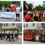
Canada Day Parade & Hike (Glen Williams)
https://hikes.brucetrail.org/event/canada-day-parade-and-hike-in-glen-williams/
Registration Required:
Click here to register for this hike (16 spots remaining)Hosting Club: Toronto
Category: Car Hike
Location (Google Maps): Ainley Trail, Glen WilliamsHike Leader(s): David Rowney Click here to contact Hike Leader(s)
Pace: Leisurely (2-3 km/hr)
Terrain: Level 2 (Intermediate – some hills and uneven surfaces, rocks and roots underfoot), Variable
Distance (km): 7 kmDescription
Looking for something fun to do on Canada Day? We’re offering you a chance to go on a hike along the Credit River footpath, then march with the Halton Hills Chapter of the Toronto Club at the Glen Williams Canada Day parade! This tiny hamlet known as the Glen, puts on a fantastic, small-town patriotic parade, just like in the movies. Afterwards, you can attend the celebration in the park, grab some food and picnic, listen to music, and tour various booths at the market. To sign up for this hike, you must also commit to participate in the parade (and bring a flag if you have one, and wear red colours!).The hike will be approximately 5k in length with an additional 2k related to the parade. Bring snacks (and a lunch if you don’t want to buy it at the park). There are washrooms at the park and we will stop for a bio break on the trail. The terrain is relatively flat with some uneven ground and a few modest hills. Wear sunscreen, hat, bring bug spray and lots of water. Dress appropriately for the weather. The pace will be moderate and relaxed.
Your itinerary for the day:
9:00 a.m. – 10 a.m.
Hike out from Glen Williams, along the Credit Valley footpath10:00 a.m. – 11:00 a.m.
Head back (there and back hike) to Glen Williams11:00 a.m. -11:30 a.m.
Walk over to the parade start on Beaver St.12:00 noon – 12:45 p.m.
March in the Canada Day parade1:00 p.m. – 3 p.m.
Enjoy the Canada Day celebrations in the parkContact David Rowney for more information 289-924-0713; david.rowney@gmail.com
(If you would like to only participate in the parade, contact Angelika Sommer: ASommer46@outlook.com) - 01July 1, 2026

Canada Day 🇨🇦 Hike - Meet time is 8:50am
https://hikes.brucetrail.org/event/canada-day-%f0%9f%87%a8%f0%9f%87%a6-hike-meet-time-is-850am/
Registration Required:
Click here to register for this hike (4 spots remaining)Hosting Club: Iroquoia
Category: General Hike
Location (Google Maps): Parking lot off of Mud StHike Leader(s): Ruth Moffatt Click here to contact Hike Leader(s)
Pace: Medium – 3 to 4 km/hr
Terrain: Moderate – Some hills and/or some poor footing, Strenuous – Hilly with steep climbs and some poor footing
Distance: 10-12kmDescription
Happy Canada Day! 🇨🇦 What better way to celebrate than a Bruce Trail Hike?!
Please wear all your Canadian colours and bring enough water and snacks for the hike. There may very well be an all- Canadian treat for everyone after the hike. - 01July 1, 2026
9:30 am Hike & Picnic HAPPY CANADA DAY
https://hikes.brucetrail.org/event/930-am-hike-picnic-happy-canada-day/
REGISTRATION FULL: This hike has reached the maximum number of hikers.
Click here to be added to the Wait List.Hosting Club: Niagara
Category: Loop
Location (Google Maps):Locust Grove Picnic Area
Hike Leader(s): Marion Hanover Click here to contact Hike Leader(s)
Pace: Medium 3- 4 km/hr
Terrain: Moderate: some hills and some poor footing
Distance: 7 kmDescription
Hike around Queenston area. Optional outdoor gathering in Locust Grove including pot luck picnic after the hike. Wear red and white for Canada Day! - 01July 1, 2026
Car Hike: Forks of the Credit
https://hikes.brucetrail.org/event/car-hike-forks-of-the-credit-7/
Registration Required:
Click here to register for this hike (14 spots remaining)Hosting Club: Toronto, Caledon Hills
Category: Car Hike
Location (Google Maps): Forks of the Credit Provincial Park, Map 15Hike Leader(s): Al Brown Click here to contact Hike Leader(s)
Pace: Moderate (3-4 km/hr)
Terrain: Hilly, Level 2 (Intermediate – some hills and uneven surfaces, rocks and roots underfoot)
Distance (km): 15-16 kmDescription
We will complete a loop hike through the Park, crossing the Credit River above the Cataract Falls. Then we will follow the trail down into the valley to a viewpoint of the Falls itself. The hike will take us by the east bank of the Credit River south then turning east and then north through the main park past glacial features and old homesteads. Natural features include kettle lakes and milkweed fields where we might spot monarch butterflies.The meeting point is the intersection of Mississauga Road and Cataract Road. Parking is located on both sides of the road. Park in marked areas only. To get to this point drive north on Mississauga Road about 3 km past Belfountain
- 02July 2, 2026
Urban Walk: Valley View/Huntington Park
https://hikes.brucetrail.org/event/urban-walk-valley-view-huntington-park-5/
Registration Required:
Click here to register for this hike (12 spots remaining)Hosting Club: Toronto
Location (Google Maps): Parking lot is off Sycamore Drive, East of Bayview , across Starbucks plaza
Bus 91 from Finch East station stops at Sycamore station.Hike Leader(s): Mohammad Aghamiri
Pace: Moderate (3-4 km/hr)
Terrain: Hilly, Level 2 (Intermediate – some hills and uneven surfaces, rocks and roots underfoot)
Distance (km): 6-7 kmDescription
We will explore Valleyview and Maple View parks, and walk along German Mill Creak, in return we stop in Huntington park and have snack under beautiful shed.Although this is considered an “Urban Walk”, you can expect some hills up and down and uneven surfaces with tree roots. Please bring hiking poles, water and snacks.
- 02July 2, 2026
Halton Agreement Forest
https://hikes.brucetrail.org/event/halton-agreement-forest-3/
Registration Required:
Click here to register for this hike (11 spots remaining)Hosting Club: Iroquoia
Category: General Hike
Location (Google Maps): Meet at the corner of 10 Side Road and 4th Line at 9:15 am.Hike Leader(s): Karen Bergmann Click here to contact Hike Leader(s)
Pace: Medium – 3 to 4 km/hr
Terrain: Moderate – Some hills and/or some poor footing
Distance: 8 kmsDescription
Meeting at 9:15 am, we will hike the bike trails around a big loop. Bring bug spray/bug net and plenty of water. - 02July 2, 2026

Hike, followed by Blues in the Park
https://hikes.brucetrail.org/event/hike-followed-by-blues-in-the-park/
Registration Required:
Click here to register for this hike (5 spots remaining)Hosting Club: Niagara
Category: Leisurely
Location (Google Maps): 2275 Dorchester Rd, Niagara Falls, ON L2J 0H1Hike Leader(s): Marion Hanover Click here to contact Hike Leader(s)
Pace: Leisurely <3 km/hr
Terrain: Moderate: some hills and some poor footing
Distance: 4 kmDescription
Hike series Thursday evenings throughout the summer, followed by optional Blues in the Park. Come prepared to hike 1.5 leisure hike. Various blues bands free of charge starting at 7pm in the park. Bring lawn chair, beverage and snack to share. - 03July 3, 2026

9:00 am Niagara on the Lake Tour & Some Yoga
https://hikes.brucetrail.org/event/900-am-niagara-on-the-lake-tour-some-yoga-25/
Registration Required:
Click here to register for this hike (40 spots remaining)Hosting Club: Niagara
Category: Urban
Location (Google Maps):Veteran’s Memorial Park, park just outside the park on King St.
Hike Leader(s): Robin Garrett Click here to contact Hike Leader(s)
Pace: Leisurely <3 km/hr
Distance: 5 km
Description
Enjoy the benefits of pausing for a yoga practice as we tour through the trails, parkland and Historic Niagara-on-the-Lake. No mat required. Movement will focus on a flow of standing poses designed especially for hikers. Plan to stay for conversation and a warm cup of coffee or tea at Sweets & Swirls, Community Centre, Niagara Stone Road, NOTL.
- 03July 3, 2026
Rural Rocks and Obese Side Trails
https://hikes.brucetrail.org/event/rural-rocks-and-obese-side-trails-2/
Registration Required:
Click here to register for this hike (8 spots remaining)Hosting Club: Sydenham, Peninsula
Category: General Hike
Location (Google Maps): This satellite loop side trail is not connected to the Main Trail. From Wiarton , take Bruce Rd 13 west for 2 km to Northacres Rd. Parking is 30 meters north of the intersection. Alternatively, if you are interested in carpooling contact the Hike Leader.Hike Leader(s): Ian Mills
Pace: Medium: 3 to 4 km/h
Terrain: Moderate: Some hills and/or poor footing
Distance: 5 kmDescription
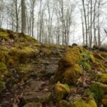
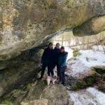
We will be hiking clockwise along the Rural Rocks side trail through a wonderland of enormous rocks left from a time when this area was the shoreline of an ancient glacier lake. We will also explore the Obese side trail which offers challenging terrain . There will be rugged hiking along with scrambling around and over numerous boulders. Please wear proper hiking boots/shoes and a walking stick may be helpful. Let me know if you are interested in lunching in Wiarton afterwards and I can sort reservations. BTC Map #35. - 03July 3, 2026
Afternoon Hike - Kelso Summit (reservation required)
https://hikes.brucetrail.org/event/afternoon-hike-kelso-summit-reservation-required-2/
Registration Required:
Click here to register for this hike (8 spots remaining)Hosting Club: Iroquoia
Category: Afternoon/Evening Hikes
Location (Google Maps): Meet at 4:15 pm in the Kelso Summit parking lot on Steeles Ave.Hike Leader(s): Karen Bergmann Click here to contact Hike Leader(s)
Pace: Medium – 3 to 4 km/hr
Terrain: Moderate – Some hills and/or some poor footing
Distance: 7 kmsDescription
Meeting at 4:15 pm, we will hike along a few of the trails in a loop. Please reserve your time for KELSO SUMMIT at www.conservationhalton.caBring bug spray/bug net.