Hike Schedule
Join us for a hike! Registration required.
All hikes available to BTC members. Some hikes are open to non-members.
See Refund Policy for Paid Hikes >
TIP: The calendar view displays up to 7 hikes on a day, but often there are more. Click “View more events” to see them all.
Categories
- 01May 1, 2026
Peninsula in 6 Challenger Series
https://hikes.brucetrail.org/event/peninsula-in-6-challenger-series-2/Sorry, the registration cut-off time for this hike has been reached.Not a member? Click here to join today!Hike open to BTC Members only.
This is a Multi-Day Hike
You are signing up for the following dates:
2026-05-01, 2026-05-02, 2026-05-03, 2026-05-08, 2026-05-09, 2026-05-10Hosting Club: Peninsula
Category: Peninsula E2E
Location (Google Maps): Bluewater Park, Wiarton, parking area opposite arena – First Hike only – Schedule with coordinates will be sent for remaining hikes to registered hikersHike Leader(s): Margaret O’Dell Click here to contact Hike Leader(s)
Pace: Brisk (4.5 – 5.5 km/h): A faster pace for those seeking a good workout or more distance.
Terrain: Difficult: Steep ascents/descents, rocky scrambling, and some rugged escarpment paths.Description
This is a Challenger series of hikes; we will complete the entire 163.1 km of the Peninsula section in 6 hikes. It is also a Paid hike; your registration fee includes a celebratory finish at the Cairn in Tobermory, the cost of the End to End badge, and contributes to fundraising for the Peninsula Bruce Trail Club hiking program activities. Please review the dates carefully to ensure you are able to participate fully. Registration is limited to 6 persons. Fees are refundable up to 30 days prior to the date of the first hike.- This hike series is intended for experienced distance hikers. Hikers must be able to sustain the distance and maintain a fast pace.
- If a hiker is unable to keep pace with the group, or finds the distance too challenging, their future hike registrations may be canceled by the hike leader.
- Be very aware of your ability to join this series.
- Hikes will average 4.5 km per hour including breaks, moving pace is 5 km per hour;
- Expect to be on-trail for 6 – 8 hours;
- Please arrive no later than 15 minutes prior to the meeting time;
- Hikers must carry sufficient hydration, accessible snacks, lunch, first-aid kit, rain gear, extra socks, and possibly protective boot covers (i.e. bags);
- Hikers will be expected to participate in shuttling hikers to the start and to drive shuttlers back to their car. Responsibility for shuttling along with any applicable parking fees will be shared within the group.
Summary of the itinerary (km based on Bruce Trail Reference – Edition 31):
- May 1: Sydney Bay Rd to Wiarton Bluewater Park – 31.7 km
- May 2: Sydney Bay Rd to Rush Cove – 26.4 km
- May 3: Richardson Side Trail to Rush Cove – 28.6 km
- May8: Richardson Side Trail to Dyers Bay – 26 km
- May 9: Dyers Bay to Halfway Dump – 27.5 km
- May 10: Halfway Dump to Tobermory – 25.2 km
A detailed schedule will be provided in advance of the series to registered hikers.
If you have concerns, or questions please use the Contact Hike Leader form to inquire in advance of registering.
- 01May 1, 2026
Peninsula End2End in 10 Series
https://hikes.brucetrail.org/event/peninsula-end2end-in-10-series/Sorry, the registration cut-off time for this hike has been reached.Not a member? Click here to join today!Hike open to BTC Members only.
This is a Multi-Day Hike
You are signing up for the following dates and times:
2026-05-01 at 07:15
2026-05-02 at 07:15
2026-05-03 at 07:15
2026-05-22 at 07:15
2026-05-23 at 07:15
2026-05-24 at 07:15
2026-05-30 at 07:15
2026-05-31 at 07:15
2026-06-06 at 07:15
2026-06-07 at 07:15Hosting Club: Peninsula
Category: Peninsula E2E
Location (Google Maps):Hike Leader(s): Saabir Sohrab Click here to contact Hike Leader(s)
Pace: Medium (3.0 – 4.5 km/h): A comfortable pace for most hikers with steady progress.
Terrain: Difficult: Steep ascents/descents, rocky scrambling, and some rugged escarpment paths., Moderate: Rolling hills, mild slopes and rocky paths.
Distance: Approx. ~166kmDescription
Peninsula E2Ein10Route: Wiarton to Tobermory (northbound)
Pace: Medium (target 3–4 km/h)
Terrain: Moderate to Difficult
Distance: ~166 km total
Daily Distances: 15.7 km · 17.8 km · 18.6 km · 15.1 km · 14.7 km · 17.8 km · 19.4 km · 22.6 km · 17.8 km · 6.7 km
Expectations: Expect 5–8 hours on the trail each day, depending on distance, terrain, weather, and group pace. The hike leader sets the pace, aiming for 3–4 km/h, and may adjust as needed for group ability and trail conditions. Breaks will be taken throughout the day.
For safety, participants must remain between the hike leader and the hike sweep at all times.
Meeting Time: 7:15 AM
Fees:
- Registration fee does not include Bruce Peninsula National Park entry fees, Cape Croker Park or MNBP parking fees
- Parking costs will be shared equally among participants.
- Badge fee included, with your choice of either the flowerpot badge or the stained glass (Turkey Vulture) badge.
- Fundraising: This hike is a fundraiser to support the Peninsula Bruce Trail Club’s volunteer-run hike program
Participant Requirements
- Intermediate/experienced hikers with good fitness
- Proper hiking boots, layered clothing, wet weather gear
- Hiking poles recommended
- Bring: Lunch, snacks, water, bug spray
Transportation & Accommodations
- Car shuttle: Participants rotate as drivers; vehicles must be passenger-ready
- Accommodations: Book early; options include motels, campgrounds, hostels, and B&Bs
Note: Dogs are not permitted.
- 01May 1, 2026
Sydenham Weekend in Owen Sound, May 1 to 3
https://hikes.brucetrail.org/event/sydenham-weekend-in-owen-sound-may-1-to-3/Sorry, the registration cut-off time for this hike has been reached.Not a member? Click here to join today!Trip Information
Departure Time: 07:30
Return to City Time: 20:00
Departure Point: York Mills Bus PickupTrip Activities
Hiking ($.01)
Optional ItemsHosting Club: Toronto
Category: Coach Trips
Location (Google Maps): Owen SoundHike Leader(s): George Lennon, Martina Furrer, Roland Mark, Robin Crombie Click here to contact Hike Leader(s)
Pace: Mixed (See Hike Description)
Terrain: Challenging, Hilly, Level 2 (Intermediate – some hills and uneven surfaces, rocks and roots underfoot), Rocky, Variable
Distance (km): 12-18 kmDescription
Join us for three days of hiking on what many consider the most rugged section of the Bruce Trail. Overnight group will be lodging at the Best Western Inn On The Bay in Owen Sound.This will be a challenging three days of hiking with some strenuous climbs and sometimes difficult footing over tree roots, rocks and crevasses. All fit, experienced hikers comfortable walking on this type or terrain are welcome. For your safety and enjoyment as well as the group’s, before registering we strongly encourage you to join some of our day hikes on the Bruce Trail. This will give you a chance to get to know us and assess your abilities.
We will split the group and offer two levels of hikes each day. The moderate group will hike about 12 km each day. and the fast group 15 km or more. The specific trails will be determined closer to the date.
Accommodation at the hotel is no longer available at the discounted group rate. Rooms at the Best Western will be at their regular rate given on the hotel’s website and/or registration desk.
Coach fare is $170 for members; $190.00 for non-members; $100 for children.
Registration instructions:
If you wish to share accommodation, please find a roommate, then book your hotel room, and then book your seats on the coach. To avoid problems make sure you and your roommate reserve your seats at the same time.
- Book your room online using the Best Western Inn on the Bay’s website (https://bwowensound.com/) or through their reservation desk (519) 371-9200. Make arrangements with your roommate to split the cost.
- To reserve your seat on the bus, register here starting on Thursday January 15 at 8 PM.
Cancellation policy: While we are hoping for sunshine, the trip cannot be cancelled due to weather. Coach fare is non-refundable if cancellation is made less than 30 days in advance of the departure date.
Our coach will depart at 7:30 AM on Friday May 1. We plan to be back in Toronto between 7 and 8 PM on Sunday May 3. Departure locations: 10 York Mills Rd and HWY 400 and Major Mackenzie Park and Ride.
- 01May 1, 2026
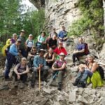
Hockley Valley Loops
https://hikes.brucetrail.org/event/hockley-valley-loops-2/Sorry, the registration cut-off time for this hike has been reached.Not a member? Click here to join today!Hosting Club: Iroquoia
Category: General Hike
Location (Google Maps): Hockley Valley Road – Bruce Trail ParkingHike Leader(s): Pati Greenwood, Jeff Dowsett Click here to contact Hike Leader(s)
Pace: Medium – 3 to 4 km/hr
Terrain: Strenuous – Hilly with steep climbs and some poor footing
Distance: 18 kmDescription
This hike will follow the main trail to Dunby Road and take in four side trails on the return route – Cam Snell, Glen Cross, Isabell East and Tom East – to form an 18 km loop back to the parking lot on Hockley Road.Wear hiking boots, bring poles. Dress for the weather conditions, bring plenty to drink and a snack.
Please arrive at the meeting place by 8:15 am for an 8:30 am departure.
- 01May 1, 2026

Queenston Tour
https://hikes.brucetrail.org/event/queenston-tour-2/Sorry, the registration cut-off time for this hike has been reached.Not a member? Click here to join today!Hosting Club: Niagara
Category: Urban
Location (Google Maps): Park at Locust Grove, Niagara River Parkway. kitty corner to the Bruce Trail Cairn.Hike Leader(s): Niagara BTC Hike Moderator, Margaret Northfield Click here to contact Hike Leader(s)
Pace: Medium 3- 4 km/hr
Terrain: Moderate: some hills and some poor footing
Distance: 6-7kmDescription
NOTL hike moves to Queenston for just this Friday. Meet at Locust Grove, Niagara River Parkway. We will hike down the escarpment to the village of Queenston. We will explore the village and the waterfront before hiking back up the escarpment to our parking. Mostly paved roads with some trail walking.Plan to stay for coffee at Commisso’s on Thorold Stone Rd, Niagara Falls.
- 01May 1, 2026
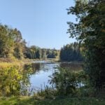
Dundas Valley
https://hikes.brucetrail.org/event/dundas-valley-2/Sorry, the registration cut-off time for this hike has been reached.Not a member? Click here to join today!Hike open to BTC Members only.
Hosting Club: Dufferin Hi-Land
Category: General Hike
Location (Google Maps): 650 Governor’s Road, Dundas, L9H 5E3. Iroquoia Section, BTC Map 8. Dundas Valley Conservation Area Parking Lot P3 just south of the main entrance. Take DVCA Trail Centre Entrance off Governors Road, near km 51.8. Click Google Map link for GPS.Hike Leader(s): Stuart Law Click here to contact Hike Leader(s)
Pace: Medium
Terrain: Slippery and Steep Sections, Moderate
Distance: 16-17 kmsDescription
Join us on hike in the Dundas Valley. We will take in part of the Bruce Trail and several DVCA trails. Lots of ups and downs and waterfalls. Please bring a warm drink, water, a snack for “elevensies”, lunch, hiking boots, poles and lots of smiles. Entrance fee to DVCA in effect at gate. Please arrive at 9:00 to be ready to hike at 9:15. We will hike two loops to allow folks to drop out after the first 10 kms if they would like. - 01May 1, 2026
Speyside from 4th Line
https://hikes.brucetrail.org/event/speyside-from-4th-line-3/Sorry, the registration cut-off time for this hike has been reached.Not a member? Click here to join today!Hosting Club: Iroquoia
Category: General Hike
Location (Google Maps): Meet at 9:15 roadside on 4th Line where the main trail crosses the roadHike Leader(s): Karen Bergmann Click here to contact Hike Leader(s)
Pace: Medium – 3 to 4 km/hr
Terrain: Moderate – Some hills and/or some poor footing
Distance: 9 kmsDescription
A new way to hike the Speyside trails, we’ll meet roadside on Fourth Line at 9:15 am and hike the main trail to the Canada Goose ST and onto the Charles Hildebrandt ST to the “unassumed road” and into Speyside from that end. Hiking around the Cliff Hatch ST and main trail back to Fourth Line. There are some very rocky sections along these trails. - 01May 1, 2026
Beaver Valley km 0-13.7
https://hikes.brucetrail.org/event/beaver-valley-km-0-13-7/Sorry, the registration cut-off time for this hike has been reached.Not a member? Click here to join today!Hosting Club: Beaver Valley
Category: Car Pool
Location (Google Maps): Meeting at end of Maple Lane. Do not park where there are no parking signed and be sure not to block driveways. We will be shuttling to Margaret Paull Side Trail parking on 6th Line and then hike back to our vehicles.Hike Leader(s): Erin Lyttle Click here to contact Hike Leader(s)
Pace: Medium
Terrain: Strenuous
Distance: 13.7Description
This hike is for those working on their Beaver Valley section end to end. We will meet at the border of Beaver Valley/Blue Mountain at the end of Maple Lane (104 Maple Ln, Ravenna, ON will get you close on GPS) and carpool to the parking on 6th Line approx 13.7km away by the trail (input 569465 6th Line, Ravenna, ON in GPS then drive on 6th line until you find the Margaret Paull Side Trail parking area. We will then hike back to our cars at Maple.This hike is for experienced hikers and while we may finish earlier, 4 hours has been allotted for this hike. We will be hiking in spring conditions (mud, ice, snow) so be prepared for it all. Please have your icers and poles at the ready and dress in layers including a waterproof outer layer. Hiking boots/shoes are mandatory. Please bring water/electrolytes and snacks, though we do not plan a meal break as this hike is scheduled between lunch and dinner time.
We will be shuttling to our starting point so please be prepared to participate in the shuttle.
- 01May 1, 2026
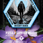
Moonlight Hike
https://hikes.brucetrail.org/event/moonlight-hike/Sorry, the registration cut-off time for this hike has been reached.Not a member? Click here to join today!Hosting Club: Iroquoia
Category: Moonlight Hikes
Location (Google Maps): Grimsby Lion’s Club Pool 1 Elm St GrimsbyHike Leader(s): Ruth Moffatt Click here to contact Hike Leader(s)
Pace: Brisk – 4 to 5 km/hr, Medium – 3 to 4 km/hr
Terrain: Dependent on Conditions, Strenuous – Hilly with steep climbs and some poor footing
Distance: 5-6kmDescription
Earn your Iroquoia Moonlight badge by hiking 3 Moonlight Hikes with a leader.
Tonight’s sunset is at 8:20pm. We will hike up the escarpment and over to the Hawkwatch area and out to Beamer’s Falls and return around 9:30pm.
If you’ve never hiked at night we are sure you will love the way it heightens all of your senses promising a great sleep afterwards.
Everyone must have a headlamp or a flashlight 🔦. Most phones have torches which could also be used as supplemental light. Please ensure your light device is fully charged/batteries to last about 1.5hours. Dress for the weather and bring enough water to suit your needs as well as all the other things you need for a hike – first aid kit, snack, poles (recommended). This is an arduous climb up the escarpment so be sure to know your physical limit.
This is the second of 3 full moon hikes to be held in Grimsby. After you complete three leader-led hikes, you will qualify for a badge. $10/$15The third moonlight hike is May 31.
Any questions may be directed through contact on this form.
If you cannot make it, please remove yourself from registration by following these steps:To cancel your registration, here is a step by step:
– Sign into your account on the BTC website
– Click on My Hikes under your account
– This will take you to a list of hikes you have registered for
– Scroll down to the appropriate hike and cursor over to the far right hand column under the Action column.
– Click Cancel under the hike you wish to cancel - 02May 2, 2026
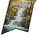
City of Waterfalls – Special Event Fundraiser
https://hikes.brucetrail.org/event/city-of-waterfalls-special-event-fundraiser-4/Sorry, the registration cut-off time for this hike has been reached.Not a member? Click here to join today!This is a Multi-Day Hike
You are signing up for the following dates and times:
2026-05-02 at 06:45
2026-05-03 at 06:45Hosting Club: Iroquoia
Category: City of Waterfalls – Special Event Fundraiser
Location (Google Maps): DAY 1: MAY 2 – Parking lot at City View Park off of Kerns Rd. Enter from Dundas St. (capacity 50) 43.351747, -79.862195
DAY 2: MAY 3 – Parking Lot off of Mud St providing access to the Mud Street Side Trail (capacity 30)Hike Leader(s): Joe Borges Click here to contact Hike Leader(s)
Pace: Medium – 3 to 4 km/hr
Terrain: Dependent on Conditions, Moderate – Some hills and/or some poor footing, Slippery and Steep Sections
Distance: Approximately 22-25km / per dayDescription
Welcome to Iroquoia, City of Waterfalls Challenge! This is a fundraiser challenge event. All funds raised go towards the Iroquoia Bruce Trail Club to maintain the infrastructure of this beautiful section of trail and to “Preserve this ribbon of wilderness, for everyone, forever!”We also encourage participants to consider a membership with Conservation Hamilton
https://conservationhamilton.ca/hca-membership-pass/And/or Conservation Halton (50%discount with BTC membership)
https://www.conservationhalton.ca/park-fees-membership-rates/DAY 1: MAY 2 – We will meet at Cityview Park and car shuttle to Spencer Gorge Parking Lot (Conservation Hamilton) and hike back. The cost at this parking lot is $16.50 per vehicle and driver plus $5.50 for each passenger.
Day 1 Distance 21kmDAY 2: MAY 3 – We will meet in the parking area off of Mud St and car shuttle to Artaban Rd Parking Lot (Conservation Hamilton) and hike back. The cost for this parking lot is $11.00 per vehicle.
Day 2 Distance 24 kmPlease ensure your vehicle is car shuttle ready by having a minimum of 4 seatbelts available – drivers do not pay for the parking. Please volunteer for this important component of this challenge or we can throw all the names into a hat. While we encourage carpooling to the start of the hike, please let the hike leader know if you’re planning to arrive with more than two people in your vehicle. This hike will be limited to 20 people including the hike leader so we will need at least 4 vehicles and one vehicle with 5 seatbelts to drive the drivers back at the end of the day. We will try to take as few vehicles as possible. On the second day, those who did not drive on the first day will be asked to drive.
There will be short breaks along the way to admire the waterfalls on route and a short lunch.
Please bring all the hiking items you require for a long day hike including 2l of water, snacks, lunch, first aid kit, rain gear if rain is forecast, plastic shower caps for your boots if muddy, bug spray, sunscreen, rimmed hat, poles (if you use them) and your camera for all the photo ops. Please ensure you are physically able to complete two long day hikes over two days – if you must drop out, you will have to arrange your own transportation back to your vehicle. There is public transportation, Uber, and taxi’s in the area. If you are concerned about whether you will be able to manage the distance over the two day period, it’s possible that you may need to wait until a 4 day version of this event is posted.
The badge will be presented to all participants who have completed the challenge at the end of the second day.
Any questions may be directed through contact on this form.