Description From Jordan Hollow Hike the main trail to Upper and Lower Balls Falls, Moyer Road or Louth and Return. You must register for each hike. Bring Poles, sunscreen, bug spray , snack and a drink and dress for the weather
Description Hike the main and side trails around Jordan and Balls Falls. Bring hiking boots, water, sunscreen and bug spray. Please arrive 10 minutes prior to start of hike.
Description Enjoy the benefits of pausing for a yoga practice as we tour through the trails, parkland and Historic Niagara-on-the-Lake. No mat required. Movement will focus on a flow of standing poses designed especially for hikers. Plan to stay for conversation and a warm cup of coffee or tea at Sweets & Swirls, Community Centre, Niagara Stone Road, NOTL.
Description Please join us on Saturday, August 3rd, for a wonderful day of hiking, swimming, and attending the annual Kempenfest, one of North America’s largest outdoor arts, crafts, and music festivals! We will hike along the Oro-Medonte Trail and onto Barrie, where you’ll have time to visit the annual Kemperfest, featuring over 400 vendors, one-of-a-kind arts and crafts, antiques, and food vendors. You may also choose to swim at Centennial Beach, sightseeing in Barrie’s downtown area, or enjoy a drink at one of the patios overlooking Barrie’s beautiful waterfront. Sign up today!
Hosting Club: Caledon Hills Category: General Location (Google Maps): Hockley Valley Nature Preserve, Map 18. To reach the meeting point, drive north on Hwy 10 from Orangeville and turn right onto Hockley Road. Continue approximately 5 km east until you see the parking area on your left, directly across the road from the Black Birch restaurant.
Pace: Brisk – 4 to 5 km/hour Terrain: Strenuous – hilly with steep climbs and some poor footing Distance: 18 km
Description Ready for a serious workout and some scenic sweat? Join us at Hockley Valley, one of the hilliest sections of the Bruce Trail and the crown jewel of the Caledon Hills BTC. This hike will be at a brisk pace, so please honestly assess your hiking abilities, this one is a killer. Come prepared with at least two liters of water, snacks, lunch, bug spray, sunscreen, electrolytes, and hiking poles if you use them. Wear appropriate clothing and footwear, and beware of the tick population this year – they’re having a boom! I highly recommend dressing like a fashionable mummy with a light long-sleeve shirt and pants.
This is also a loop hike – no shuttling required!
Please note that this is a 2SLGBTQIA+ friendly hike. Everyone is welcome. And after we’ve conquered the hills, feel free to join me at the Black Birch restaurant for some well-deserved refreshments!
Hosting Club: Blue Mountains Category: Register in person the morning of hike. Location (Google Maps): Hike meets in the parking lot behind Tim Hortons on First St. in Collingwood.
Pace: Leisurely – 3 km/hr. or less Terrain: Easy – Mostly flat and usually good footing Distance: 5 km
Description We will follow the Georgian Trail past former Railway Station to the Nippising Ridge Trail and return. This is an easy hike with lots of opportunities to recall the history of Craigleith.
Description The Town of Niagara-on-the-Lake has a significant and nation-shifting Black history. Voices from the past will tell their stories, enriching hikers’ understanding of how they shaped this town and nation.
Watch a short video by Historica Canada about Richard Pierpoint’s life by opening the link below.
https://youtu.be/UQyPXOHvwEc?si=2ZPGIHDrybxv11f
*Please be prepared for the sun as this hike is largely in the open (e.g., sunscreen, head covering and hydration).
** This hike counts towards the Black History badge. Three hikes from the series are required.
PLEASE NOTE: Hikes are offered by volunteers who have committed to their own learning to be able to offer informative and contemplative hike experiences. These hikes are open to all and offered in a spirit of mutual leaning and inclusion.
Pace: Leisurely: 3 km/h or less Terrain: Moderate: Some hills and/or poor footing Distance: 3 km
Description We will carpool to do a loop hike of one of the Woodford trails. This will be hike 9 in the book Exploring Sydenham. There will be a secret to find. If you do not yet have the book I will have some for sale at $30 (cash or e-transfer). This hike was originally scheduled as the 2nd part of Sun 23 Jun 2024,
Hosting Club: Iroquoia, Dufferin Hi-Land Category: General Hike Location (Google Maps): Boyne Valley Provincial Park – parking lot on Prince of Wales Drive 80 metres south of Prince of Wales Side Trail
Pace: Medium – 3 to 4 km/hr Terrain: Moderate – Some hills and/or some poor footing, Strenuous – Hilly with steep climbs and some poor footing Distance: 13 km
Description We will hike BT side trails and the main trail for 13K loop. This hike will feature some steep climbs and more moderate terrain. We will meet at the parking lot on Prince of Wales Drive just south of the Prince of Wales Side Trail. Bring plenty of water and a snack. Please arrive by 8:15 am as we will eave promptly at 8:30 am.
Description Earn the new E2E badge by completing the Niagara Section of the Bruce Trail in 5 hikes. This series will run each Tuesday morning for 5 consecutive weeks. If you are unable to attend all the hikes you can keep a log and complete the missed hikes at another time. You will still be able to earn the badge once all the sections are complete. Badges will be available for purchase at the end of the 5th hike. $10 for members, $15 for non members.
This is a carpool hike. Please arrive 15 minutes early so we can arrange carpooling. Driving is voluntary but we encourage all hikers to take their turn to help out. Bring water and a snack. The hikes go rain or shine. Poles, weather appropriate clothing, sturdy hiking shoes and bug spray are recommended.
We will carpool to Louth Conservation and hike back to the cars at Quarry Rd.
You are signing up for the following dates and times: 2024-08-06 at 09:00 2024-08-07 at 08:30 2024-08-08 at 08:30 2024-08-09 at 08:30 2024-08-19 at 09:00 2024-08-20 at 08:30 2024-08-21 at 08:30 2024-08-22 at 08:30
Pace: Brisk Terrain: Challenging, Variable Distance: 24.4 km
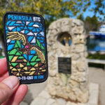
Description Thank you for registering to the Stain Glass, fund raising hike of the Peninsula. This will be a fundraising hike series in 8. Each hiker will be allowed to miss one hike and make it on their. The funds for this hike will be collected by the Toronto club and it will be transferred to the Peninsula club to help maintain the trail and keep the pledge of Ribbon Of Wilderness For Everyone, Forever. on the first hike we will shuttle to km and hike back. hike 2- we will meet at km 44.1, Hope Bay coordinates N 44.902930,W 81.155706 map 37 and shuttle to km 24.4
hike 3- we will meet at km 44.1, Hope Bay and will shuttle to km 67.9 and walk back.
hike 4- we will meet at km 87.5, Richardson Side Trail, coordinates N 45.020460,W 81.283790 map 39, we will shuttle to km 67.9 and walk back. hike 5- we will meet at Richardson SideTrail and shuttle to km 110.6 – (may be a paid parking) and walk back.
hike 6- we will meet at km 110.6 coordinates N 45.147416,W 81.338921 map 40, we will shuttle to km 125.4 Crane Lake and walk back.
hike 7- we will meet at Crane Lake, km 124.4 coordinates N 45.190813,W 81.419658, map 41 we will shuttle to Cyprus Lake, parking B. this is a paid parking and will add about 2km to the hike. We will go on the trail that leads to mars lake, km 145.5 and walk back.
hike 8- we will park in Tobermory, there are some places that are free parking, we will park in a free parking place that I will explain how to get there during the duration of the hike. We will shuttle to cypress Lake, ( paid parking) and walk back. It’s badge day at the cairn, pictures and treats. please bring 2 or more litres of water, snacks and lunch. Everyone is expected to participate in the shuttle once or twice in the duration of the 8 days.
Description Hike around Short Hills Provincial Park. Please bring water, sunscreen snd insect repellent. Following the hike be sure to check yourself for ticks and clean boots to prevent the spread of invasive species.
Hosting Club: Caledon Hills Category: General Location (Google Maps): Park at BTC 7th Line Parking Lot located 200 metres from km 43.3 off the 7th Line immediately east of Airport Road, 43.960477, -79.979773.
Driving Directions: From Airport Road/Peel Regional Road 7, turn east onto 7 Line E/7th Line EHS. Parking is on the right side. (North of Mono Mills)
Pace: Medium – 3 to 4 km/hour Terrain: Moderate – some hills and/or some poor footing Distance: 10 kilometres
Description HIKE CANCELLED DUE TO HEAVY RAIN IN THE FORECAST. The Founders’ Footpath is a Bruce Trail Conservancy initiative to mark the upcoming 60th Anniversary of the founding of the Bruce Trail. Help the CHBTC select a section of the trail that best exemplifies the founders’ intentions. Explore Finalist A: Main Trail km 42.5 – 47.5 and Darcy’s Side Trail 0.5 km; south of 7th Line to north of 5 Sideroad; BTC Protected Areas: Humber Heights, Twin Waters Nature Reserve, Mathilda’s Way, Dr. Philip Gosling Nature Reserve, Tall Timbers, Scarlett, and Moule Easement. Bring snacks and your choice of hydration. Sturdy footwear is highly recommended. This hike can be logged towards earning the 60 for the 60th Anniversary badge.
Hosting Club: Blue Mountains Category: Register in person the morning of hike. Location (Google Maps): Hike meets in the parking lot behind Tim Hortons on First St. in Collingwood.
Pace: Medium – 3 to 4 km/hr Terrain: Moderate – Some hills and/or some poor footing Distance: 11.5 km
Description We will drive to the start of the hike at the roadside parking area near the cemetery located 1 km east of Lavender on Mulmur/Nottawasaga Townline. We will hike along the road until we reach Lavender where km 0.0 is the start of the Blue Mountains section. We will continue hiking past the bridge over the Noisy River and up to County Rd. 9 then retrace our steps. This hike offers a variety of terrain as we proceed along crevices, through forest, fields, and beautiful wetlands before reaching the Noisy River. Bring lunch and water.
Description Please join me for an enjoyable fitness walk on a relatively flat and easy trail around the lake in the Island Lake Conservation area. The trail has treed sections as well as boardwalks near the water, meadows with beautiful flowers and much more. We will keep some steady but still comfortable pace of approximately 3 km/h. We will have a short break on the picnic area after about 6 km. Please bring 2 L of water, sunglasses, hut and some snacks/light lunch. We will meet at the start of the trail (near the large trail map) at 4th Ave and Hwy 10 intersection. You can park anywhere at the Zehrs Orangeville, Winners or Mark’s parking lot which is just across Hwy 10,
Pace: Brisk: 4 to 5 km/h Terrain: Moderate: Some hills and/or poor footing Distance: Approx 5 km
Description Join us for an evening hike exploring Owen Sound neighbourhoods, followed by an opportunity for refreshments. No need to show up 15 minutes early for this hike, but we will leave promptly at 7 pm.
Description From Jordan Hollow Hike the main trail to Upper and Lower Balls Falls, Moyer Road or Louth and Return. You must register for each hike. Bring Poles, sunscreen, bug spray , snack and a drink and dress for the weather
Description Hike the main and side trails around Jordan and Balls Falls. Bring hiking boots, water, sunscreen and bug spray. Please arrive 10 minutes prior to start of hike.
Hosting Club: Caledon Hills Category: End-to-End Location (Google Maps): Meet at Creditview Rd. north of the Grange Sideroad on the Devils Pulpit Side Trail, southwest of km 5.2. Shuttle to start at Escarpment Sideroad.
Pace: Medium – 3 to 4 km/hour Terrain: Easy – mostly flat and usually good footing, Moderate – some hills and/or some poor footing Distance: 15.9 – 5.2 + 1.3 of side trail = 12.0 km total
Description This is the fifth hike of the series and follows the recent trail changes around the Forks of the Credit area.
Pace: Medium – 3 to 4 km/hr Terrain: Moderate – Some hills and/or some poor footing Distance: 10-12 kms
Description We will meet at park behind Kilbride Public School and hike along Kilbride Street to Twiss Road and onto the main trail at 8th Line – this will meet up with the River and Ruins side trail which we will take along Bronte Creek and then follow a private trail to Lowville to snack/lunch at Lowville Park – There is an outdoor sculpture garden we can wonder through on the way -we will return by completing the River and Ruins side trail and back out onto main trail and follow blue trail- side streets back to our vehicles
Must bring Water and wear suitable clothing for weather- Lunch/snack/poles/hat/bug spray/sunscreen –
Any concerns or questions, please text or email me through this form.
Hosting Club: Niagara Category: Urban Location (Google Maps): Meet on King St near Centre St just outside of Veterans Memorial Park, Niagara-on-the-Lake
Description Each Friday we will explore different neighbourhoods, trails and parkland throughout Historic Niagara-on-the-Lake.
Moderate pace with some weeks entirely on sidewalks and roads while others may include a mix of trails and paved pathways. Great way to build up endurance for longer more strenuous hikes.
Prepare for cooler windy conditions on open parkland and along Lake Ontario and Niagara River trails.
Plan to stay for conversation and a warm cup of coffee or tea at Sweets & Swirls, Community Centre, Niagara Stone Road, NOTL
Pace: Medium – 3 to 4 km/hr Terrain: Strenuous – Hilly with steep climbs and some poor footing Distance: 9 km
Description HIKERS MUST contact the hike leader if ON-LINE REGISTRATION has closed. NO morning sign-ins on this series as hikers will meet at trailhead. Description: about 9 km with a little over 400m elevation gain. Park your car on the side of the road near the Noisy River Provincial Park sign [44.27499, -80.20731]. Proceed south on the white blazed trail crossing the Noisy River via the new bridge, for 1.5 km until you come to a small bench overlooking a pond. Turn around and head back to the car. Repeat this twice more for a total of three 3 km trips. [go to https://www.alltrails.com/explore/map/map-7ac52e3–69 for a detailed map of this hike]. This is a hilly hike, so bring lots of water and lunch. Congratulations you’ve completed the NoisyTriple, a fitting end to the Rim 2 Rim Triple Run. Don’t forget to go online to order your hard earned badge ($10).
Hosting Club: Toronto Category: Urban Walk Location (Google Maps):
Meet in the Great Hall of Union Station by the information desk with the clock with no later than 8:30 AM to take the Lakeshore West train towards West Harbour departing at 8:45 AM
Description From Aldershot GO Station we will hike to scenic Hidden Valley Park and the Hendrie Valley Sanctuary, a popular spot for birdlife. Then on to Burlington Heights and the Hamilton Waterfront Trail to catch the train back to Toronto from the West Harbour GO Station. Optional drop out at Burlington Heights by taking the local bus to Burlington GO Station. Optional pub stop at Fisher’s Pier 4 pub 10 minutes walk Harbour GO Station.
We will hike from Aldershot GO Station in Burlington to West Harbour Station in Hamilton via Hidden Valley Park, Hendrie Valley (RBG), Burlington Heights, and the Hamilton Waterfront Trail. The route is mostly flat with the exception of one hill to reach Burlington Heights to connect with the Waterfront Trail. Hendrie Valley features a lovely boardwalk through the wetlands. The total distance is about 12 km and we will walk at an average pace of 3 to 3.5 km per hour (and less than 4.).
We will take the train departing Union Station at 8:44 and arriving at Aldershot at 9:55. You may meet Tom in the Great Hall by the information desk with the clock over it to depart by 8:30 or find us in the upper level of the accessibility coach if boarding at a station on the way. The train will stop at Mimico Station at 9:00 and Port Credit Station at 9:13.
Trains depart West Harbour Station hourly at 23 minutes past the hour. There will be an optional pub stop 10 minutes walk from the station. Ice cream is also available at Hutches fish and chips next to the GO station. Arrival at West Harbour is expected to be approximately just after 2:00 PM.
If you have a cell phone with data you may purchase the $10 day pass at the link below. Make sure to select Weekend Day Pass and not an E-Ticket. The senior return fare from Union is less than $11.00 so with the “One Fare” program covering the TTC ride to the GO station it’s cheaper for seniors to use their Presto Card.
Hosting Club: Toronto Category: Car Hike Location (Google Maps): Glasgow Trail, Concession Road 2 Park in parking lot at the trail head.
From Highway 404 turn right to Stouffville Rd, till to the end of road and turn left on York Durham line in About 1km turn right to Webb Rd. and turn right to Concession Road 2 ,you will see parking lot in 500 meters
Pace: Moderate (3-4 km/hr) Terrain: Variable Distance: 14-17 km
Description Lets explore Goodwood conservation area and visit Secord forest and pond
Approximately 5-hour hike, bring lots of water and protect yourself from mosquitos
Some safety procedures during the hike:
1-Hikers must stay between the leader and the sweep.
2-Hikers must advise the leader or the sweep if they wish to leave the group.
3- Hikers must follow the whistle instructions: 1 blast- stay where you are; 2 blasts come to the leader; 3 blasts – come to the leader quickly.
4-Hike leader may request volunteers to stop at trail intersections, they need to help hikers to the direction the group walk and wait till they see the sweep .
5-Hikers have to make sure they can see the persons behind and in front of them.
Description Join us for a scenic and easy paced walk, a regular summer favorite led by Wayne Crockett, along the trails running through Norfolk County ending at historic Port Dover. The route is primarily on rail trails so is ideal for those who favor a flatter and easier route in the summer heat. Dropout at 8km. After the walk there will be the opportunity to indulge in the local perch fish and chips or hang out at the beach which together make Port Dover famous. Long Distance Bus Fare applies and there will be a late return (after 6:00 Pm).
Hosting Club: Caledon Hills Category: General Location (Google Maps): Mono Cliffs Provincial Park, Map 19. To reach the meeting place, drive north on Hwy 10 past Orangeville. Continue to Mono Centre Road (crossroad name is Camilla). Turn right and follow this road into Mono Centre. The Community Centre parking lot is on your right, about 200 meters before you reach the crossroads.
Pace: Brisk – 4 to 5 km/hour Terrain: Moderate – some hills and/or some poor footing Distance: 16 km
Description Join us for a delightful loop hike through the Provincial Park, featuring the scenic Splitrock and Ralph Tremills Side Trails. This route is mostly flat with a few small hills at the start, making it an easy and enjoyable hike for everyone. Hiking boots are recommended for comfort and safety. For those who prefer a shorter adventure, there is an option to complete an 8 km hike.
After the hike, everyone is invited to join me at the Hockley Resort for some well-deserved refreshments.
Directions To reach the meeting place, drive north on Hwy 10 past Orangeville. Continue to Mono Centre Road (crossroad name is Camilla). Turn right and follow this road into Mono Centre. The Community Centre parking lot is on your right, about 200 meters before you reach the crossroads.
This hike is a 2SLGBTQIA+ friendly space. Everyone is welcome to join, enjoy the trail, and share in the beauty of the Provincial Park!
Hosting Club: Caledon Hills Category: General Location (Google Maps): Finalist A – Park at BTC 7th Line Parking Lot located 200 metres from km 43.3 off the 7th Line immediately east of Airport Road, 43.960477, -79.979773.
Driving Directions: From Airport Road/Peel Regional Road 7, turn east onto 7 Line E/7th Line EHS. Parking is on the right side. (North of Mono Mills)
Finalist B – Park at BTC parking lot on the east side of the 5th Line EHS, just south of Hockley Road, 43.993572, -80.014057.
Driving Directions: From the 7th Line EHS parking lot return to Airport Road. Turn right and continue to Hockley Road. Turn left and proceed to 5th Line EHS. Turn south/left onto 5th Line EHS. The parking lot is on the left in 100 metres.
Finalist C: Park at BTC Parking Lot, 713377 1st Line EHS, Mono, 43.959916, -80.070494.
Driving Directions: From the 5th Line EHS parking lot return to Hockley Road. Turn left and proceed to 3rd Line EHS. Turn left and continue to 5 Sideroad. Turn right onto Side Road 5 for 1.5 kilometres. Turn right onto 1st Line EHS for approximately 1 kilometre. Continue straight into the parking lot.
Pace: Medium – 3 to 4 km/hour Terrain: Strenuous – hilly with steep climbs and some poor footing Distance: 21.5 kilometres
Description The Founders’ Footpath is a Bruce Trail Conservancy initiative to mark the upcoming 60th Anniversary of the founding of the Bruce Trail. Help the CHBTC select a section of the trail that best exemplifies the founders’ intentions. This hiking adventure explores the three finalist footpaths. Hike all three or join the hikes that most interest you. Contact Sandy for approximate meetup times.
Finalist A: Main Trail km 42.5 – 47.5 and Darcy’s Side Trail 0.5 km; South of 7th Line to north of 5 Sideroad; BTC Protected Areas: Humber Heights, Twin Waters Nature Reserve, Mathilda’s Way, Dr. Philip Gosling Nature Reserve, Tall Timbers, Scarlett, and Moule Easement.
Upon completion, the group will drive to Finalist B: Main Trail km 48.9 – 52.1, Hemlock Ridge Side Trail 0.61 km, and Glacier Valley Side Trail 0.58 km; Airport Road to 5th Line EHS Parking Lot; BTC Protected Areas: Cedar Highlands, Galbraith, and Hemlock Ridges.
Next, will be Finalist C: Goodyear Memorial Side Trail 2.2 km, Rushing Rivers Side Trail 0.2 km, and Upland Side Trail 1.2 km; BTC Protected Areas: The Akela and Scouters Heather and Ross Hamlin at Riverside Woods Nature Reserve, and Rushing River Nature Reserve.
Bring snacks and your choice of hydration. Sturdy footwear is highly recommended.
These hikes can be logged towards earning the 60 for the 60th Anniversary badge.
Hosting Club: Blue Mountains Category: Register in person the morning of hike. Location (Google Maps): Hike meets in the parking lot behind Tim Hortons on First St. in Collingwood.
Pace: Leisurely – 3 km/hr. or less Terrain: Easy – Mostly flat and usually good footing Distance: 6 km
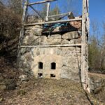
Description We will take the Franks Kiln Side Trail before heading out on the white blazed trail. View a lime kiln, restored by some of BMBTC volunteers, that was originally built circa 1860. Enjoy the view once we arrive at the “Wedding Tree”. We will carry on for a distance and then retrace our steps back to the “Wedding Tree” where we will stop for a picnic. Bring your own picnic lunch and water. Many, many moons ago, a young couple were married by an old maple tree, situated on top of the Niagara Escarpment overlooking the Georgian Bay on the Bruce Trail, located in the upper field of the Franks’ Highfield Farm, Duntroon. The young couple affixed to the tree a carved wooden sign citing all the details of the event (bagpiper and all)! Alas, this thoughtful record went missing in 2015! Wouldn’t it be nice if it was found, as another relative would like to record their wedding on it. Thereby, formally identifying the tree as “The Wedding Tree”. Bring a snack and water.
Description The Town of Niagara-on-the-Lake (NOTL) has a significant and nation-shifting Black history. On this hike, voices from the past will tell their stories, enriching hikers understanding of how they shaped this town and nation.
Open the link below to hear about the Ontario Heritage Trust Plaques honoring Black history in NOTL.
https://www.youtube.com/watch?v=6ah7N5DuBRo
*Please be prepared for the sun/heat as this hike is largely in the open(e.g., hydration, sunscreen, etc.).
**This hike counts as 1 of 3 in the Summer 2024 series required for the Black history badge.
PLEASE NOTE: Hikes are offered by volunteers who have committed to their own learning to be able to offer informative and contemplative hike experiences. These hikes are open to all and offered in a spirit of mutual leaning and inclusion.
Pace: Medium: 3 to 4 km/h Terrain: Strenuous: Hilly with steep climbs and some poor footing. Distance: 5.5 kms
Description We will meet at Harrison Park and then carpool to the Parking lot for Centennial Tower on Hwy 6/10 and hike the very technical section to Harrison Park. You will see some spectacular geology, climb over large boulders, walk along cliff faces and through crevices. The Palisade Figure 8 loop is a stunningly beautiful section of the Bruce Trail. A blue side trail will take us from the Palisades back to Harrison Park, where we might stop in for refreshments. Good footwear is important, bring water, and poles are advised. Email the hike leader for more information.
Hosting Club: Toronto Category: Urban Walk Location (Google Maps): Main Street Unionville, Main Street Markham, Milne Dam Conservation Area, Rouge Valley Trail
Description Visit the old villages of Unionville and Markham Village and part of the Rouge Valley Trail system in the City of Markham.
We will meet at Varley Art Gallery of Markham in Main Street Unionville after the art event from 2:00 PM – 4:00 PM: https://visitmarkham.ca/event/curators-corner-discovering-art-together/
If you are not planning to join the event at the gallery, the meeting time for the walk is 4:00 PM at the entrance outside the gallery.
We will walk along the loop at Too Good Pond before heading to Bruce Creek, Austin Park, and Milne Dam Conservation Area along the Rouge Valley Trail, arriving at Main Street Markham. From this point on it will be road walking as we head back to Main Street Unionville. Drop-out points are available along the way with access to public transit and passing by Markham GO Station and Centennial GO Station.
Arriving in Main Street Unionville in the evening hours, there is the option to return home or have a walk on Main Street Unionville and/or have a refreshment stop. (https://unionville.ca/)
Please refer to the route map: https://onthegomap.com/s/t3o2m013
Pace: Medium – 3 to 4 km/hr Terrain: Strenuous – Hilly with steep climbs and some poor footing Distance: 9 km
Description HIKERS MUST contact the hike leader if ON-LINE REGISTRATION has closed. NO morning sign-ins on this series as hikers will meet at trailhead. Description: about 9 km with a little over 400m elevation gain. Park your car on the side of the road near the Noisy River Provincial Park sign [44.27499, -80.20731]. Proceed south on the white blazed trail crossing the Noisy River via the new bridge, for 1.5 km until you come to a small bench overlooking a pond. Turn around and head back to the car. Repeat this twice more for a total of three 3 km trips. [go to https://www.alltrails.com/explore/map/map-7ac52e3–69 for a detailed map of this hike]. This is a hilly hike, so bring lots of water and lunch. Congratulations you’ve completed the NoisyTriple, a fitting end to the Rim 2 Rim Triple Run. Don’t forget to go online to order your hard earned badge ($10).
Hosting Club: Toronto Category: Urban Walk Location (Google Maps):
Meet in the Great Hall of Union Station by the information desk with the clock with no later than 8:30 AM to take the Lakeshore West train towards West Harbour departing at 8:45 AM
Description From Aldershot GO Station we will hike to scenic Hidden Valley Park and the Hendrie Valley Sanctuary, a popular spot for birdlife. Then on to Burlington Heights and the Hamilton Waterfront Trail to catch the train back to Toronto from the West Harbour GO Station. Optional drop out at Burlington Heights by taking the local bus to Burlington GO Station. Optional pub stop at Fisher’s Pier 4 pub 10 minutes walk Harbour GO Station.
We will hike from Aldershot GO Station in Burlington to West Harbour Station in Hamilton via Hidden Valley Park, Hendrie Valley (RBG), Burlington Heights, and the Hamilton Waterfront Trail. The route is mostly flat with the exception of one hill to reach Burlington Heights to connect with the Waterfront Trail. Hendrie Valley features a lovely boardwalk through the wetlands. The total distance is about 12 km and we will walk at an average pace of 3 to 3.5 km per hour (and less than 4.).
We will take the train departing Union Station at 8:44 and arriving at Aldershot at 9:55. You may meet Tom in the Great Hall by the information desk with the clock over it to depart by 8:30 or find us in the upper level of the accessibility coach if boarding at a station on the way. The train will stop at Mimico Station at 9:00 and Port Credit Station at 9:13.
Trains depart West Harbour Station hourly at 23 minutes past the hour. There will be an optional pub stop 10 minutes walk from the station. Ice cream is also available at Hutches fish and chips next to the GO station. Arrival at West Harbour is expected to be approximately just after 2:00 PM.
If you have a cell phone with data you may purchase the $10 day pass at the link below. Make sure to select Weekend Day Pass and not an E-Ticket. The senior return fare from Union is less than $11.00 so with the “One Fare” program covering the TTC ride to the GO station it’s cheaper for seniors to use their Presto Card.
Hosting Club: Toronto Category: Car Hike Location (Google Maps): Glasgow Trail, Concession Road 2 Park in parking lot at the trail head.
From Highway 404 turn right to Stouffville Rd, till to the end of road and turn left on York Durham line in About 1km turn right to Webb Rd. and turn right to Concession Road 2 ,you will see parking lot in 500 meters
Pace: Moderate (3-4 km/hr) Terrain: Variable Distance: 14-17 km
Description Lets explore Goodwood conservation area and visit Secord forest and pond
Approximately 5-hour hike, bring lots of water and protect yourself from mosquitos
Some safety procedures during the hike:
1-Hikers must stay between the leader and the sweep.
2-Hikers must advise the leader or the sweep if they wish to leave the group.
3- Hikers must follow the whistle instructions: 1 blast- stay where you are; 2 blasts come to the leader; 3 blasts – come to the leader quickly.
4-Hike leader may request volunteers to stop at trail intersections, they need to help hikers to the direction the group walk and wait till they see the sweep .
5-Hikers have to make sure they can see the persons behind and in front of them.
Description Join us for a scenic and easy paced walk, a regular summer favorite led by Wayne Crockett, along the trails running through Norfolk County ending at historic Port Dover. The route is primarily on rail trails so is ideal for those who favor a flatter and easier route in the summer heat. Dropout at 8km. After the walk there will be the opportunity to indulge in the local perch fish and chips or hang out at the beach which together make Port Dover famous. Long Distance Bus Fare applies and there will be a late return (after 6:00 Pm).
Hosting Club: Caledon Hills Category: General Location (Google Maps): Mono Cliffs Provincial Park, Map 19. To reach the meeting place, drive north on Hwy 10 past Orangeville. Continue to Mono Centre Road (crossroad name is Camilla). Turn right and follow this road into Mono Centre. The Community Centre parking lot is on your right, about 200 meters before you reach the crossroads.
Pace: Brisk – 4 to 5 km/hour Terrain: Moderate – some hills and/or some poor footing Distance: 16 km
Description Join us for a delightful loop hike through the Provincial Park, featuring the scenic Splitrock and Ralph Tremills Side Trails. This route is mostly flat with a few small hills at the start, making it an easy and enjoyable hike for everyone. Hiking boots are recommended for comfort and safety. For those who prefer a shorter adventure, there is an option to complete an 8 km hike.
After the hike, everyone is invited to join me at the Hockley Resort for some well-deserved refreshments.
Directions To reach the meeting place, drive north on Hwy 10 past Orangeville. Continue to Mono Centre Road (crossroad name is Camilla). Turn right and follow this road into Mono Centre. The Community Centre parking lot is on your right, about 200 meters before you reach the crossroads.
This hike is a 2SLGBTQIA+ friendly space. Everyone is welcome to join, enjoy the trail, and share in the beauty of the Provincial Park!
Hosting Club: Caledon Hills Category: General Location (Google Maps): Finalist A – Park at BTC 7th Line Parking Lot located 200 metres from km 43.3 off the 7th Line immediately east of Airport Road, 43.960477, -79.979773.
Driving Directions: From Airport Road/Peel Regional Road 7, turn east onto 7 Line E/7th Line EHS. Parking is on the right side. (North of Mono Mills)
Finalist B – Park at BTC parking lot on the east side of the 5th Line EHS, just south of Hockley Road, 43.993572, -80.014057.
Driving Directions: From the 7th Line EHS parking lot return to Airport Road. Turn right and continue to Hockley Road. Turn left and proceed to 5th Line EHS. Turn south/left onto 5th Line EHS. The parking lot is on the left in 100 metres.
Finalist C: Park at BTC Parking Lot, 713377 1st Line EHS, Mono, 43.959916, -80.070494.
Driving Directions: From the 5th Line EHS parking lot return to Hockley Road. Turn left and proceed to 3rd Line EHS. Turn left and continue to 5 Sideroad. Turn right onto Side Road 5 for 1.5 kilometres. Turn right onto 1st Line EHS for approximately 1 kilometre. Continue straight into the parking lot.
Pace: Medium – 3 to 4 km/hour Terrain: Strenuous – hilly with steep climbs and some poor footing Distance: 21.5 kilometres
Description The Founders’ Footpath is a Bruce Trail Conservancy initiative to mark the upcoming 60th Anniversary of the founding of the Bruce Trail. Help the CHBTC select a section of the trail that best exemplifies the founders’ intentions. This hiking adventure explores the three finalist footpaths. Hike all three or join the hikes that most interest you. Contact Sandy for approximate meetup times.
Finalist A: Main Trail km 42.5 – 47.5 and Darcy’s Side Trail 0.5 km; South of 7th Line to north of 5 Sideroad; BTC Protected Areas: Humber Heights, Twin Waters Nature Reserve, Mathilda’s Way, Dr. Philip Gosling Nature Reserve, Tall Timbers, Scarlett, and Moule Easement.
Upon completion, the group will drive to Finalist B: Main Trail km 48.9 – 52.1, Hemlock Ridge Side Trail 0.61 km, and Glacier Valley Side Trail 0.58 km; Airport Road to 5th Line EHS Parking Lot; BTC Protected Areas: Cedar Highlands, Galbraith, and Hemlock Ridges.
Next, will be Finalist C: Goodyear Memorial Side Trail 2.2 km, Rushing Rivers Side Trail 0.2 km, and Upland Side Trail 1.2 km; BTC Protected Areas: The Akela and Scouters Heather and Ross Hamlin at Riverside Woods Nature Reserve, and Rushing River Nature Reserve.
Bring snacks and your choice of hydration. Sturdy footwear is highly recommended.
These hikes can be logged towards earning the 60 for the 60th Anniversary badge.
Hosting Club: Blue Mountains Category: Register in person the morning of hike. Location (Google Maps): Hike meets in the parking lot behind Tim Hortons on First St. in Collingwood.
Pace: Leisurely – 3 km/hr. or less Terrain: Easy – Mostly flat and usually good footing Distance: 6 km
Description We will take the Franks Kiln Side Trail before heading out on the white blazed trail. View a lime kiln, restored by some of BMBTC volunteers, that was originally built circa 1860. Enjoy the view once we arrive at the “Wedding Tree”. We will carry on for a distance and then retrace our steps back to the “Wedding Tree” where we will stop for a picnic. Bring your own picnic lunch and water. Many, many moons ago, a young couple were married by an old maple tree, situated on top of the Niagara Escarpment overlooking the Georgian Bay on the Bruce Trail, located in the upper field of the Franks’ Highfield Farm, Duntroon. The young couple affixed to the tree a carved wooden sign citing all the details of the event (bagpiper and all)! Alas, this thoughtful record went missing in 2015! Wouldn’t it be nice if it was found, as another relative would like to record their wedding on it. Thereby, formally identifying the tree as “The Wedding Tree”. Bring a snack and water.
Description The Town of Niagara-on-the-Lake (NOTL) has a significant and nation-shifting Black history. On this hike, voices from the past will tell their stories, enriching hikers understanding of how they shaped this town and nation.
Open the link below to hear about the Ontario Heritage Trust Plaques honoring Black history in NOTL.
https://www.youtube.com/watch?v=6ah7N5DuBRo
*Please be prepared for the sun/heat as this hike is largely in the open(e.g., hydration, sunscreen, etc.).
**This hike counts as 1 of 3 in the Summer 2024 series required for the Black history badge.
PLEASE NOTE: Hikes are offered by volunteers who have committed to their own learning to be able to offer informative and contemplative hike experiences. These hikes are open to all and offered in a spirit of mutual leaning and inclusion.
Pace: Medium: 3 to 4 km/h Terrain: Strenuous: Hilly with steep climbs and some poor footing. Distance: 5.5 kms
Description We will meet at Harrison Park and then carpool to the Parking lot for Centennial Tower on Hwy 6/10 and hike the very technical section to Harrison Park. You will see some spectacular geology, climb over large boulders, walk along cliff faces and through crevices. The Palisade Figure 8 loop is a stunningly beautiful section of the Bruce Trail. A blue side trail will take us from the Palisades back to Harrison Park, where we might stop in for refreshments. Good footwear is important, bring water, and poles are advised. Email the hike leader for more information.
Hosting Club: Toronto Category: Urban Walk Location (Google Maps): Main Street Unionville, Main Street Markham, Milne Dam Conservation Area, Rouge Valley Trail
Description Visit the old villages of Unionville and Markham Village and part of the Rouge Valley Trail system in the City of Markham.
We will meet at Varley Art Gallery of Markham in Main Street Unionville after the art event from 2:00 PM – 4:00 PM: https://visitmarkham.ca/event/curators-corner-discovering-art-together/
If you are not planning to join the event at the gallery, the meeting time for the walk is 4:00 PM at the entrance outside the gallery.
We will walk along the loop at Too Good Pond before heading to Bruce Creek, Austin Park, and Milne Dam Conservation Area along the Rouge Valley Trail, arriving at Main Street Markham. From this point on it will be road walking as we head back to Main Street Unionville. Drop-out points are available along the way with access to public transit and passing by Markham GO Station and Centennial GO Station.
Arriving in Main Street Unionville in the evening hours, there is the option to return home or have a walk on Main Street Unionville and/or have a refreshment stop. (https://unionville.ca/)
Please refer to the route map: https://onthegomap.com/s/t3o2m013
Hosting Club: Caledon Hills Category: General Location (Google Maps): Hockley Valley Nature Reserve, Map 18. To reach the meeting point, drive north on Hwy 10 from Orangeville and turn right onto Hockley Road. Continue approximately 5 km east until you see the parking area on your left, directly across the road from the Black Birch restaurant.
Pace: Medium – 3 to 4 km/hour Terrain: Strenuous – hilly with steep climbs and some poor footing Distance: 14 km
Description Join us for a 14 km hike through the Nature Reserve, known for being one of the most challenging and hilly sections of the Bruce Trail. Get ready for a workout, After the hike, those interested are welcome to join me at the Hockley Valley Resort for refreshments.
We are committed to providing an inclusive and welcoming environment. This hike is an 2SLGBTQIA+ safe space, and everyone is welcome to join us!
Description We will hike on the main trail from Vineland Estates Winery towards Cave Springs Conservation Area and return back to Vineland Estates Winery by 11:30. Upon return we will enjoy a private structured wine tasting led by one of the knowledgeable and friendly winery staff from 11:30 to 12:00 noon. The cost for the tasting experience is $12.00 per person. Please bring your $12.00 with you as I will collect it prior to the tasting to simplify the payment to Vineland Estates Winery. Thank you.
Pace: Medium – 3 to 4 km/hr Terrain: Moderate – Some hills and/or some poor footing Distance: 14K
Description We will hike the main trail and side trails for 14K loop. We will meet at the Bruce Trail Pear Tree Parking Lot on 15 Sideroad, 200 m southwest of Halton Road 25. Bring plenty of water and a snack. Please arrive by 8:15 am as we will leave promptly at 8:30 am.
Description Earn the new E2E badge by completing the Niagara Section of the Bruce Trail in 5 hikes. This series will run each Tuesday morning for 5 consecutive weeks. If you are unable to attend all the hikes you can keep a log and complete the missed hikes at another time. You will still be able to earn the badge once all the sections are complete. Badges will be available for purchase at the end of the 5th hike. $10 for members, $15 for non members.
This is a carpool hike. Please arrive 15 minutes early so we can arrange carpooling. Driving is voluntary but we encourage all hikers to take their turn to help out. Bring water and a snack. The hikes go rain or shine. Poles, weather appropriate clothing, sturdy hiking shoes and bug spray are recommended.
We will carpool to Quarry Rd and hike back to the cars at Lions Club Pool, Grimsby.
Description Hike the main and side trails in Shorthills Provincial Park. Bring hiking boots, water, sunscreen and bug spray. Please help prevent the spread of invasive species by cleaning your boots following the hike. Please check yourself for ticks following the hike.
Hosting Club: Caledon Hills Category: Tuesday Hikers Location (Google Maps): Meet at Vicki Barron Lakeside Trail Parking. After driving through Orangeville traffic lights on Highway 10, turn right on Hockley Rd., keep straight on SIderoad 5, turn right on Hurontario Street and proceed to the end for the car parking.
Pace: Medium – 3 to 4 km/hour Terrain: Easy – mostly flat and usually good footing Distance: 10 – 11 km
Description Will hike around Island Lake, may take few diversions into the side trails for a total of 10-11 km, completing a loop around the lake. Will be watching for birds, other wild life in the lake and enjoy the summer season. There may be an optional refreshment stop after the hike at a local eatery. Bring sunscreen, bug spray, two litres of water and your choice of snack for the break.
Hosting Club: Blue Mountains Category: Register online ONLY Location (Google Maps): Hike meets in the parking lot behind Tim Hortons on First St. in Collingwood.
Pace: Medium – 3 to 4 km/hr Terrain: Moderate – Some hills and/or some poor footing Distance: 10.4 km
Description The Mill Creek Valley: “Castle Ramparts” at Stop 8 (Pages 63/64) The Manitoulin Dolostone layer of the Niagara Escarpment forms a steep edge along the valley of Mill Creek. Over time the thinly bedded rock breaks away from the cliff face and lies scattered along the slope. Many shell and horn coral fossils can be found in these flat, shingle-like rocks. Note that when leaves are fully out in the summer months the “castle ramparts” may be hard to see. A photograph of the talus rock below the cliff will be sufficient for this badge location.
Pace: Medium Terrain: Moderate, Some rocky footing, Some steep sections Length of Hike: 5.9 km
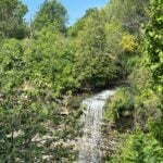
Description This hike takes us through BTC protected land. We will walk through a mature deciduous forest on the Main Trail and then we’ll walk the Stew Hilt’s Side Trail. Crossing a stream, we reach a waterfall, usually trickling in the fall. Our route will have us return on the higher Main Trail which provides a beautiful view of the Cuckoo Valley, showcasing fall colour.
COVID-19 Precautions Before, During and After your Hike
Each hiker joining a Bruce Trail Club organized hike must perform a self-screening check before hiking. Find Ontario’s self-assessment tool here: https://covid-19.ontario.ca/self-assessment/
If you are experiencing COVID-19 symptoms, stay home.
Other Guidelines
Arrive 15 minutes before the start of the hike.
Wear sturdy footwear and appropriate attire for the weather and the terrain. Hiking poles are a good idea in any season, especially if the terrain is rocky or slippery. In winter, snowshoes or icers/crampons are needed when conditions dictate. Wearing appropriate clothing and footwear prevents injuries and shows consideration for a safe and positive group hiking experience.
Always carry I.D. and your health card.
Bring sufficient water and snacks (or lunch if indicated). A minimum of 1L of water is recommended on all hikes, and 3L is recommended for long, challenging hikes in the heat of the summer.
Bring sunscreen and insect repellent (for spring and summer hikes).
Description From Jordan Hollow Hike the main trail to Upper and Lower Balls Falls, Moyer Road or Louth and Return. You must register for each hike. Bring Poles, sunscreen, bug spray , snack and a drink and dress for the weather
Hosting Club: Dufferin Hi-Land Category: General Hike Location (Google Maps): Bruce Trail parking lot on the 1st Line E, just south of 10 Side Road, east of Whitfield.
Pace: Leisurely Terrain: Dependent on Conditions, Slippery Sections Likely Distance: 3 to 5.5 kms
Description Join BTC Trail Ambassadors Anna and Eric for a hike focusing on native woodland plant species, herbaceous ferns and trees. We will also identify mushrooms and birds if present and able.We will hike 3.5km from 1st line east on main trail and then loop back on the Moss Haven side trail and main. For those wishing to continue we will then cross the road and hike approx 1.5km on the Rick hill section and then return to the parking lot. Please arrive by 8:45 and we will leave promptly by 9am. Please bring water, bug spray and a snack.
Description Hiking in and around Jordan, Jim Rainforth Trail and Balls Falls. The hike to Balls Falls, every third week, is longer by 1/2 hour approximately.
Description Hike the main and side trails around Jordan and Balls Falls. Bring hiking boots, water, sunscreen and bug spray. Please arrive 10 minutes prior to start of hike.
Hosting Club: Caledon Hills Category: End-to-End Location (Google Maps): Meet at Boston Mills Road, southwest of km 48.4 in the Toronto Section. Shuttle to start on Creditview Road.
Pace: Medium – 3 to 4 km/hour Terrain: Easy – mostly flat and usually good footing, Moderate – some hills and/or some poor footing Distance: 5.2 – 0.0 + 1.3 of Side Trail + 2.4 of Toronto = 8.9 km total
Description This is the last hike of the series and takes us through the Cheltenham Badlands before reaching the Spirit Tree Cidery!
Pace: Leisurely – 3km/hr or less Terrain: Moderate – Some hills and/or some poor footing Distance: Approx. 7-8 km.
Description Hike the lovely trails of this area with a great views towards Rattlesnake Point. Meet in the lower parking lot at Crawford Lake Conservation Area at 9:15 for a 10:00 am. start. Bring water, a snack, insect repellent and sunscreen. Hiking poles might be useful. We may get lucky and see some Turkey Vultures. Reservation with Halton Parks is necessary.
Contact the hike leader through this form if there are any questions.
Description Join Nina and Barbara from Loving Yoga for the third annual fundraising event to help restore the natural beauty and habitat of BTC Nature Reserves on the Saugeen Bruce Peninsula. This year’s fundraising event will support the restoration at Vanishing Streams Nature Reserve. This is an outdoor yoga and meditation experience with one of the most magnificent views of Georgian Bay from the Bruce Trail. All levels, including beginners, welcome.
Your teachers will guide you through mindful & gentle yoga and meditation practices above the stunning lookout point. Since it was so well received last year, Barbara will bring back the Yoga Tune Up therapy balls and you will have the opportunity to experience firsthand the benefits of self-massage through rolling.
Part of the experience will be guided in silence, heightening your awareness & senses and connecting to nature. We will wrap up the experience with some social time and a picnic under the trees overlooking Georgian Bay. There will be plenty of time for spectacular photographs and short, self-guided walks nearby.
Cost: Free will donation. Please consider donating generously for this worthwhile fundraiser. A tax deductible receipt is available upon request. Last year’s fundraising supported tree planting and meadow restoration at Maple Cross Nature Reserve at Cape Chin. This year, 100% of proceeds will be directed toward the PBTC Vanishing Streams restoration work. Payment received by cash or cheque at the event , or etransfer to Bruce Trail Conservancy upon registration. No refunds.
Parking: Please arrive at 388 Cape Chin Road North, Lion’s Head about 1/2 hour prior to starting time. This will give you time to drive up the winding driveway (3 1/2 km) to the yoga location. Please park directly behind the previous vehicle. If you need to leave before lunch, please let Marg know.
What to bring:
Yoga mat or towel (large towel preferable on the grass)
Tennis ball or yoga tune up ball
Water bottle, bug spray, etc
Picnic lunch (bring your own lunch)
Raindate: August 29th. Same time.
For more information about Nina and Barbara at Loving Yoga: lovingyoga.ca
Description Enjoy the benefits of pausing for a yoga practice as we tour through the trails, parkland and Historic Niagara-on-the-Lake. No mat required. Movement will focus on a flow of standing poses designed especially for hikers. Plan to stay for conversation and a warm cup of coffee or tea at Sweets & Swirls, Community Centre, Niagara Stone Road, NOTL.
Hosting Club: Iroquoia, Toronto Category: Car Hike Location (Google Maps): Parking area beside Mill St at the Smokey Hollow Side Trail. GPS Coordinates N43.330803, W79.886980
Description At a moderate to brisk pace we’ll hike from Borer’s Falls to the Great Falls at Smokey Hollow while enjoying the rhythmic and calming sound of Grindstone Creek rushing water. Please bring snack, lunch and sufficient water for hydration. Bring sun screen, sun head protection and bug spray in the event our friendly mosquitoes welcome us. Comfortable hiking shoe/boot and poles are strongly suggested. Please dress accordingly to weather forecast for the area. Please make sure your personal medication and health card is with you at all times. No drop out.
Hosting Club: Toronto Category: Urban Walk Location (Google Maps): Meet at Bethesda Trail Head Parking on Bethesda Sideroad off Bayview Avenue, across from Lake Wilcox. This parking lot is free. From Finch subway station take blue bus to Richmond hill Centre and then Bus 91B to Bethesda Sideroad and then walk 600 meter to parking lot and meeting point, Please check the public transit one day before hike.
Pace: Moderate (3-4 km/hr) Terrain: Hilly, Variable Distance: 14-15 km
Description Join us to explore Jefferson Forest and Bond lake
Please bring hiking poles, proper closing and shoes and lots of water,
Please carefully read safety procedures during the hike:
1-Hikers must stay between the leader and the sweep.
2-Hikers must advise the leader or the sweep if they wish to leave the group.
3- Hikers must follow the whistle instructions: 1 blast- stay where you are; 2 blasts come to the leader; 3 blasts – come to the leader quickly.
4-Hike leader may request volunteers to stop at trail intersections, they need to help hikers to the direction the group walk and wait till they see the sweep .
5-Hikers have to make sure they can see the persons behind and in front of
Hosting Club: Caledon Hills Category: General Location (Google Maps): Hockley Valley Nature Reserve, Map 18. To reach the meeting point, drive north on Hwy 10 from Orangeville and turn right onto Hockley Road. Continue approximately 5 km east until you see the parking area on your left, directly across the road from the Black Birch restaurant.
Pace: Brisk – 4 to 5 km/hour Terrain: Strenuous – hilly with steep climbs and some poor footing Distance: 18 km
Description THIS HIKE HAS BEEN CANCELLED DUE TO BAD WEATHER – PLEASE DO NOT REGISTER!!
Ready for a serious workout and some scenic sweat? Join us at Hockley Valley, one of the hilliest sections of the Bruce Trail and the crown jewel of the Caledon Hills BTC. This hike will be at a brisk pace, so please honestly assess your hiking abilities, this one is a killer. Come prepared with at least two liters of water, snacks, lunch, bug spray, sunscreen, electrolytes, and hiking poles if you use them. Wear appropriate clothing and footwear, and beware of the tick population this year – they’re having a boom! I highly recommend dressing like a fashionable mummy with a light long-sleeve shirt and pants.
This is also a loop hike – no shuttling required!
Please note that this is a 2SLGBTQIA+ friendly hike. Everyone is welcome. And after we’ve conquered the hills, feel free to join me at the Black Birch restaurant for some well-deserved refreshments!
Pace: Leisurely (2-3 km/hr) Terrain: Flat, Variable Distance: 10 km
Description
Please join us for a relaxing and picturesque hike along the Niagara River Recreation Trail. Along the way, we’ll explore the Botanical Gardens, which boasts 99 acres of meticulously maintained gardens, including a world-famous rose garden, the Niagara Glen Nature Centre, and the Whirlpool Area, among other places. As we navigate the trails, we will take in the Niagara River’s breathtaking views and its powerful rapids. There will be time for picture-taking and learning about Niagara’s history and ecology. We’ll follow the scenic Niagara River to Downtown Niagara, stopping for refreshments after the hike.
Trip Information: Departure Time: 9:00 a.m. Return to City Time: 6:00 p.m. Departure Point: Kipling Station North Parking Lot https://maps.app.goo.gl/pudZxLwvbcjR9vLq8
Description The Town of Niagara-on-the-Lake (NOTL) has a significant and nation-shifting Black history. Voices from the past will tell stories, enriching hikers’ understanding of how they shaped this town and nation.
See link below for a brief overview of NOTL’s Black History.
*Be prepared for the sun/heat as this hike is largely in the open (e.g., hydration, sunscreen, etc.).
**This hike counts as 1 of the 3 required hikes in the Summer 2024 series towards the Black History badge.
PLEASE NOTE: Hikes are offered by volunteers who have committed to their own learning to be able to offer informative and contemplative hike experiences. These hikes are open to all and offered in a spirit of mutual leaning and inclusion.
Hosting Club: Caledon Hills Category: General Location (Google Maps): Boyne Valley Provincial Park, Map 20 of the BTC Trail Guide. County Rd. 19 (Prince of Wales Rd.) Parking Area – west of km 15.2 – approximately 80 metres south of the Prince of Wales Side Trail.
Pace: Brisk – 4 to 5 km/hour Terrain: Strenuous – hilly with steep climbs and some poor footing Distance: 17 km
Description Join us for an invigorating hike starting from the parking lot on Prince of Wales Rd. We’ll explore the Prince of Wales Side Trail, Primrose Loop Side Trail, main trail, and Boyne Valley Side Trail, looping back via the main trail and Prince of Wales Side Trail. Along the way, we’ll hike up the short side trail to Murphy’s Pinnacle, where you’ll be rewarded with a stunning view of the surrounding landscape – great for Instagram!
Bring lunch, plenty of water, and hiking poles if you use them, as the trail is hilly. Dress for the weather and note that this hike will happen rain or shine!
This hike is a 2SLGBTQIA+ friendly space. Everyone is welcome to join us for this adventure and enjoy the beauty of the trails together.
Directions:
Boyne Valley Provincial Park, Map 20 of the BTC Trail Guide. County Rd. 19 (Prince of Wales Rd. ) Parking Area – west of km 15.2 – approximately 80 metres south of the Prince of Wales side Trail.
Pace: Leisurely: 3 km/h or less Terrain: Moderate: Some hills and/or poor footing Distance: 13.2 km
Description We will carpool to do a loop hike in the Bayview area. This will be hike 13 in the book Exploring Sydenham. There will be a secret to find. If you do not yet have the book I will have some for sale at $30 (cash or e-transfer). This hike will start in the morning due to its length. Ensure that you come prepared for a longer hike by bring at least 2 l of water and a lunch.
Join us for the NBTC Nature Hike series to learn more about the biodiversity along the Niagara Escarpment. We will explore the trails throughout Louth Conservation Area which offer beauty in all four seasons. Hikes will be held January, May, August & October – it will be amazing to see all the changes throughout the seasons. Your hike leaders, members of the NBTC Biodiversity Committee, will share their knowledge of the amazing flora & fauna along the trail as well as any biodiversity projects in the works for this year.
Parking is at the Louth Conservation Area Parking Lot on Staff Ave. Hiking boots and poles are recommend as the terrain is very rocky in sections.
Note that the hike will be rescheduled in the event of heavy rains or heavy snow.
Description Please meet be by 10:30 am (by the bus stop) in the parking lot of the plaza on the south east corner of Steeles Ave West and Dufferin St.
We will hike south through G Ross Lord Park, returning to Steeles for an estimated distance of 8.5 km. The pub stop is Montana’s on Steeles west of Dufferin for those who wish to join me.
Bring a snack, 2 liters of water, bug spray and sun screen.
Here is an online map of our route G Ross Lord Park
Note: Registration closes 48 hours before the start of the hike.
Description Hike the trails in Short Hills Provincial Park. Please bring water, sunscreen and bug spray. Following the hike check ourself for ticks and clean boots to prevent the spread of invasive species.
Hosting Club: Caledon Hills Category: Tuesday Hikers Location (Google Maps): City View Park, Burlington. From Highway 403 going west, turn right on Brant Street, left on Dundas Street, left on Kerns Rd., take second turn left into City View Park to the parking lot.
Pace: Medium – 3 to 4 km/hour Terrain: Moderate – some hills and/or some poor footing Distance: 11 km
Description From City View Park will connect with main Bruce Trail and hike to Smokey Hollow waterfall, also hike Kings ST and Eric Best ST on the way. After snack break will trace back our steps and return to parking. It’s an opportunity to get back to hiking after well deserved summer break and reconnect with fellow hikers. Bring water, snack for refreshment break at Smokey Hollow. Poles are recommended.
Pace: Leisurely – 3km/hr or less Terrain: Moderate – Some hills and/or some poor footing Distance: Approx. 6 – 7 km.
Description This hike will be in an area with an interesting history of quarrying limestone with old lime kilns as well as the famous “Hole in the Wall”. We will use main trail and side trails to explore the area to see the former lime kilns and the activity in this area. There will be one challenging area where the footing is tricky as we climb through the “hole”. Meet in the parking lot on Fifth Line, next to the baseball fields at 9:45 for a 10:00 am. start. Bring water, a snack, insect repellent, sunscreen and poles if using.
Please contact the hike leader via this form if you have any questions.
Pace: Medium – 3 to 4 km/hr Terrain: Moderate – Some hills and/or some poor footing Distance: 5 kms
Description We will hike around the Great Esker Side Trail and a bit on the main trail. This is a loop hike and there are a few hilly bits. Bring bug spray/bug net.
Hosting Club: Blue Mountains Category: Register in person the morning of hike. Location (Google Maps): Hike meets in the parking lot behind Tim Hortons on First St. in Collingwood.
Pace: Medium – 3 to 4 km/hr Terrain: Moderate – Some hills and/or some poor footing Distance: 11.5 km
Description We will drive to the Beaver Valley Ski Resort parking lot. The hike starts at the junction of the Beaver Valley Crossover Side Trail and the Kimberly Forest Side Trail. We will hike north on the Kimberly Forest Side Trail to the white blazed trail at km 83.1 then north to km 83.6 to do an in and out hike of the Wodehouse Karst Side Trail We will then return south on the white blazed trail to the Valley Crossover Side Trail at km 79.5. From here it is all downhill to the Beaver Valley Ski Resort parking lot. Bring lunch and water.
Location (Google Maps): Park in the small BTC parking lot on the north side of Graham’s Hill Road, just west of where the Trail crosses Graham’s Hill Road at km 74.2, Map 26, Edition 31
Pace: Medium Terrain: Moderate, Some rocky footing, Some steep sections Length of Hike: 4.2 km
Description This is a there-and-back hike along a varied stretch of Valley edge. Karst topography, old growth forest and streams with waterfalls are on our route as well as meadow and wild fruit trees. There are long views across the Valley.
COVID-19 Precautions Before, During and After your Hike
Each hiker joining a Bruce Trail Club organized hike must perform a self-screening check before hiking. Find Ontario’s self-assessment tool here: https://covid-19.ontario.ca/self-assessment/
If you are experiencing COVID-19 symptoms, stay home.
Other Guidelines
Arrive 15 minutes before the start of the hike.
Wear sturdy footwear and appropriate attire for the weather and the terrain. Hiking poles are a good idea in any season, especially if the terrain is rocky or slippery. In winter, snowshoes or icers/crampons are needed when conditions dictate. Wearing appropriate clothing and footwear prevents injuries and shows consideration for a safe and positive group hiking experience.
Always carry I.D. and your health card.
Bring sufficient water and snacks (or lunch if indicated). A minimum of 1L of water is recommended on all hikes, and 3L is recommended for long, challenging hikes in the heat of the summer.
Bring sunscreen and insect repellent (for spring and summer hikes).
Pace: Moderate Terrain: Hilly, Variable Distance: ca 10 km
Description Please join me for an enjoyable fitness hike on a hilly part of the park. We will hike a 10 km loop with one section going up hill. The trail has mostly treed sections as well as a few open areas. There will be a lunch stop near the Credit River. Be prepared wearing comfortable cloths, hiking shoes/boots. Please bring at least 2 L of water, a light lunch/snacks, sun screen and bug spray optional. We will on the parking lot at the trail head and map poster to the right of the washroom facilities. You have to drive to the main entrance on the McLaren Road and pay for the parking.
Description From Jordan Hollow Hike the main trail to Upper and Lower Balls Falls, Moyer Road or Louth and Return. You must register for each hike. Bring Poles, sunscreen, bug spray , snack and a drink and dress for the weather
Description Join us for an exhilarating adventure along the Burnt Point loop. This hike promises unforgettable views and a moderately challenging terrain that will keep your senses engaged from start to finish.
We’ll begin our journey at the Viewing Tower of Bruce Peninsula National Park, Visitors Center at 9am sharp. Be sure to arrive a few minutes early to prepare for our 2.5-hour exploration. As we set off, get ready for a workout with repeated uphill and downhill sections, navigating through the rugged landscape of uneven and exposed roots and rocks, and testing your balance on rocky beaches.
Dress in layers to accommodate the ever-changing weather conditions typical of the area, and lace up sturdy footwear. Don’t forget your camera to capture the breathtaking vistas of Fathom Five National Marine Park and the serene shoreline of Georgian Bay.
Throughout our trek, you’ll be serenaded by the melodious songs of the local bird life as we weave through picturesque cedar forests. Remember to bring ample water to stay hydrated, along with a packed lunch and snacks to refuel during our adventure.
Please note that while the guided hike is complimentary, there is a park admission fee. If you possess a National Park Pass, your entrance is covered, otherwise, admission fee can be paid at the Visitors Center upon arrival. Our starting point offers convenient parking at the Visitors Center Parking Lot, located at 120 Chi Sin Tib Dek Rd, Tobermory ON N0H 2R0.
Rain or shine, this hike promises an invigorating experience immersed in nature’s splendor. Prepare to discover the hidden gems of the Bruce Peninsula and create lasting memories on this scenic exploration.
Time commitment is approximately 2.5hrs.
Park Admission Fee: We will be hiking on a section of the Bruce Trail which is located within the National Park boundary. The Guided Hike is free. However, Park admission fees apply and can be purchased at the Visitors Centre. If you have a National Park Pass, your admission is already covered.
Parking at: Visitors Centre Parking Lot located at 120 Chi sin tib dek Rd, Tobermory ON N0H 2R0.
Meet at: Bruce Peninsula National Park Visitors Centre [120 Chi sin tib dek Rd, Tobermory ON N0H 2R0]. Please arrive a few minutes prior to our starting time of 9am.
Description Hike the main and side trails around Jordan and Balls Falls. Bring hiking boots, water, sunscreen and bug spray. Please arrive 10 minutes prior to start of hike.
Pace: Medium – 3 to 4 km/hr Terrain: Moderate – Some hills and/or some poor footing Distance: 12 km
Description We will hike through Hilton Falls Conservation Area on the Hilton Falls Side Trail and Conservation Area trails. Bring water and snacks. Wear clothing and footwear appropriate to weather conditions. Insect repellent is recommended.
Park in Hilton Falls Conservation Area parking lot, accessible from Campbellville Road. Reservations are required. For further information see Conservation Halton web site: https://www.conservationhalton.ca/parks/hilton-falls/
Please arrive by 8:15 am as we will depart promptly at 8:30 am.
Hosting Club: Peninsula Category: Peninsula Blue Series Location (Google Maps): Meet up at Colpoy’s Bay Government Dock Parking Lot, off Bruce Road 9 . We will carpool a short distance to Rural Rootz Nature Reserve. Map 35 (Bruce Trail Reference Guide 30th Edition)
Description Working on your PBTC Blue Series? This Rural Rocks Side Trail loop is a hidden gem! Rural Rocks Side Trail, and its short Obese Side Trail, are part of only few Bruce trail sections not connected to the main trail. The side trails found here follow some difficult terrain – the section passing through cathedral type rock formations is very rugged. You also pass through patches of moss and fern, a maple-birch-balsam forest, and pass by an active beaver pond. Join Margie, a new PBTC new Hike Leader, on her first guided hike. Meet at Colpoy’s Bay Government Dock parking lot, off Bruce Road 9, at 9:00 a.m. We will carpool a short distance to the Rural Rootz Nature Reserve. Expect this hike to be approximately 2 hours. Bring a light backpack with plenty of water, snacks, insect repellent, sunscreen, hiking poles (optional). Wear a hat and sturdy footwear.
Hosting Club: Niagara Category: Urban Location (Google Maps): Meet on King St near Centre St just outside of Veterans Memorial Park, Niagara-on-the-Lake
Description Each Friday we will explore different neighbourhoods, trails and parkland throughout Historic Niagara-on-the-Lake.
Moderate pace with some weeks entirely on sidewalks and roads while others may include a mix of trails and paved pathways. Great way to build up endurance for longer more strenuous hikes.
Prepare for cooler windy conditions on open parkland and along Lake Ontario and Niagara River trails.
Plan to stay for conversation and a warm cup of coffee or tea at Sweets & Swirls, Community Centre, Niagara Stone Road, NOTL
Pace: Medium – 3 to 4 km/hr Terrain: Strenuous – Hilly with steep climbs and some poor footing Distance: 38 km
Description Please refer to the written description of the Spring/Summer/Fall Rim2Rim Badge on the BMBTC website. All three RIM hikes MUST be completed on the same day. The 3R2Rs in a DAY Challenge badge will be red, orange and yellow to reflect the level of difficulty. Currently, this hike badge is only available by registering on-line. The cost of the badge is $15 for members and $20 for non-members. You must have a vehicle to drive yourself to each RIM. You are encouraged to have a partner hiker with similar pace to complete the challenge as this will not be a traditional hike led by a leader, everyone’s pace differs. You MUST have a cell phone since there are no leaders/sweeps or drop out spots with volunteers. If you use the designated parking spots you will never be more than 6 kms away from your vehicle. You determine your rest stop frequency, and snack or meal needs as well as refreshments. You can decide what items to leave in the car (extra water and snacks) that don’t need to be carried for each “leg of the challenge”. You can plan to have lunch breaks at your car if desired. You must ensure you have plenty of water in your pack for each RIM. As this hike requires a significant amount of driving from one RIM to the next, we have included an outline below of the approximate time involved. Car travel times [according to Google Maps] from Bruce Trail Parking on 33/34 Sideroad [44.428118, -80.276849] to Devil’s Glen Provincial Park parking [44.36161, -80.20824] = 14 min for 14 km Car travel times [according to Google Maps] from Devil’s Glen Provincial Park parking [44.36161, -80.20824] to Noisy River Nature Preserve parking [44.27499, -80.20731] = 12 min for 15 km You and your partner should plan to set a pace between 4-6 km/hr ●Approximate time needed to finish about 40 km @ 6 km/hr = 6 hrs + 40 min + half an hour travel/resting/eating/drinking time = just over 7 hrs ●Approximate time needed to finish about 40 km @ 5 km/hr = 8 hrs + half an hour travel/resting/eating/drinking time = 8 and 1/2 hrs ●Approximate time needed to finish about 40 km @ 4 km/hr = 10 hrs + half an hour travel/resting/eating/drinking time = 10 and 1/2 hrs (The distance as measured by GPS is actually closer to 38km)
You are signing up for the following dates and times: 2024-08-24 at 07:30 2024-08-25 at 07:30 2024-08-31 at 07:30 2024-09-01 at 07:30 2024-09-02 at 07:30
Location (Google Maps): Meet in the Kolapore Uplands skiers parking lot on Grey County Road 2, 650 m south of where the trail crosses the road at km 23.8. Plan to be there at 7:30 a.m. for sign in and bus loading.
Pace: Medium Terrain: Moderate, Some rocky footing, Some steep sections, Strenuous Length of Hike: The 5 hikes range from approx. 22 km 26 km. You set your own pace but medium will get the job done in a timely fashion.
Description
Beaver Valley 2024 End-to-End
August 24, 25, 31 and September 1, 2
Please note that the event will be subject to current COVID protocols.
Registration will be through the Bruce Trail Conservancy Online Calendar and will open at 8:30 a.m. on March 1, 2024. Registration is limited to 50 people because of parking area availability. Once registration is full, names will be added to a wait list by the Online Calendar software. The registration fee of $110.00 (members) $120.00 (non members) includes the online registration fee, bus shuttle, refreshments and the End-to-End badge. There will be no refunds for this event as it is a fundraiser. Hikers should have experience with hiking 20+ km in a day.
Complete details of the event will be emailed to participants once registration is received. For more information contact beavervalleytrailactivities@gmail.com
Hosting Club: Toronto Category: Urban Walk Location (Google Maps): Boyd Conservation Park, Islington Avenue, Vaughan, ON free parking at the entrance of the park,
There are different public transit routes to this parking lot please check transit maps/google map
Pace: Moderate Terrain: Variable Distance: 14-17 km
Description Explore the trails that wind through the beautiful valley at Boyd Conservation Area and the William Grainger Greenway. We will have lunch/snack in shelter with seated area,
Please bring hiking poles, proper closing and shoes and lots of water,
Please carefully read safety procedures during the hike:
1-Hikers must stay between the leader and the sweep.
2-Hikers must advise the leader or the sweep if they wish to leave the group.
3- Hikers must follow the whistle instructions: 1 blast- stay where you are; 2 blasts come to the leader; 3 blasts – come to the leader quickly.
4-Hike leader may request volunteers to stop at trail intersections, they need to help hikers to the direction the group walk and wait till they see the sweep .
5-Hikers have to make sure they can see the persons behind and in front of
Pace: Moderate (3-4 km/hr) Terrain: Flat Distance: 15.8 km
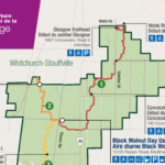
Description On this hike we will continue to explore the Rouge National Urban Park, this time in the section of the park in Markham, Pickering, and Whitchurch-Stouffville, starting in the Black Walnut Day Use Area in Markham. We will explore the Northeast Trail (10.7 km) and the Harvest Trail (5.1 km).
The meeting point will be the York Mills Bus Pickup location. There is an additional pickup location at Unionville GO Station – select that option when registering if you would like to be picked up there.
The meeting time is 8:30 AM at the York Mills pickup location and 8:45 AM at the Unionville GO Station pickup location.
This will be a relatively easy and leisurely hike. The terrain is relatively flat with some stairs. The surface condition consist of compacted granular trails and boardwalks. The pace will be a moderate pace of 4 km/hr.
There will be a drop-out point at 10.7 km after the Northeast Trail. The total distance covering all the trails will be 15.8 km.
After the hike there will be a refreshment stop at the Muddy York Brewery in Whitchurch-Stouffville or on Main Street Stouffville.
For your reference, the Park Map for the Rouge can be found at:
Hosting Club: Blue Mountains Category: Register online ONLY Location (Google Maps): Hike meets in the parking lot behind Tim Hortons on First St. in Collingwood.
Pace: Medium – 3 to 4 km/hr Terrain: Moderate – Some hills and/or some poor footing Distance: 14 km
Description Experienced hikers only! Very challenging. We will start the Pacific Slope Trail (Sendero Pacífico) Friendship Trail at the Johnston’s Sideroad parking area at km74.3. We will head south through a high meadow that has magnificent views west across the Cuckoo Valley (you might even see the Penn stocks) and the high edges of the Escarpment. Continuing to km 73.6 we will take the Stew Hilts Side Trail to see the splendiferous waterfall! Check out the exposed Queenston Shale formation, red- gray, and gray-green shales. We are never too far from the sound of falling water as we make steep descents and ascents all the way to km 68.3 (East Back Line). We will then turn around and make our way back UP to the cars! Keeping in mind, this hike is challenging and strenuous as the descents are at the beginning of the hike and the steep and continuous ascents are at the end. **The Pacific Slope Trail (Sendero Pacífico, Costa Rica) section is twinned with the Bruce Trail. It begins in San Luis in the famous Monteverde Cloud Forest conservation region, and leads into the Children’s Eternal Rainforest Bring a snack or lunch and water.
Hosting Club: Blue Mountains Category: Register in person the morning of hike. Location (Google Maps): Hike meets in the parking lot behind Tim Hortons on First St. in Collingwood.
Pace: Leisurely – 3 km/hr. or less Terrain: Moderate – Some hills and/or some poor footing Distance: 5 km
Description We will park at km 67.5 on the Lower Valley Road in the Beaver Valley section. We will hike on the Hoggs Falls Lower Side Trail, join up with the white blazed trail and continue north. Meeting up with the Hoggs Falls Upper Side Trail, we will hike west to form a loop back to the cars. The trail leads through forests, climbs out of the creek valley and follows along the edge of an open field before dropping down again onto an old logging road and into the beginning of a wide valley. Bring a snack or lunch and water.
The Town of Niagara-on-the-Lake (NOTL) has a significant and nation-shifting Black history. On this hike, voices from the past will tell their stories, enriching hikers understanding of how they shaped this town and nation.
This is the last of the Summer 2024 series of hikes.
*Be prepared for the sun/heat as this hike is largely in the open (e.g., hydration, sunscreen, etc.).
**This hike counts as 1 of the 3 required hikes in the Summer 2024 series towards the Black History badge.
Please Note: Hikes are offered by volunteers who have committed to their own learning, to be able to offer informative and contemplative hike experiences. These hikes are opened to all and offered in a spirit of mutual learning and inclusion.
Pace: Leisurely, Medium Terrain: Moderate Distance: Two options: ~4km and ~7km
Description Join us for a free, family friendly guided Summer’s End Rainbow Hike for 2SLGBTQ+ folx and allies. Meet at Bluewater Park in Wiarton. We will leave some cars at Bluewater Park and carpool from here to Wright’s Crescent. At Wright’s Crescent, we will gather together before dividing into two hiking groups. This hike will offer two options – one for a shorter, slower paced (~3.7 km) hike and the other a faster paced and longer hike (7 km). The faster and longer hike participants will begin their hike along Purple Valley Side Trail to the Main Trail. They will follow the Main Trail through the forest at Malcolm Bluffs Nature Reserve and along the pretty clifftop of Colpoy’s Bay before returning on the Bob Light and Malcolm Bluff Side Trail to the parking lot. This moderately paced hike is relatively flat but on uneven terrain and requires good balance. While the longer hike participants are on their way, the shorter, slower paced hike participants will carpool from Wright’s Crescent to Crawford Drive parking area ( a very short drive). Here we will hike on Crawford Drive Side Trail to the Main Trail – a relatively flat but uneven trail. On the Main Trail we will hike along the top of the Escarpment to the Purple Valley Side Trail, returning to Wright’s Crescent and the rest of the parked vehicles. Bring a light backpack to carry water and snacks. Wear supportive footwear with good tread and closed toes. We will have ample time for taking photos and taking short breaks. Hike duration for both hikes will be about 2 – 2 1/2 hours. Portapotties are available at the Wright’s Crescent parking lot. After our hikes, we will carpool back to Bluewater Park.Please join us for a potluck picnic here.
Pace: Medium – 3 to 4 km/hr Terrain: Strenuous – Hilly with steep climbs and some poor footing Distance: 38 km
Description Please refer to the written description of the Spring/Summer/Fall Rim2Rim Badge on the BMBTC website. All three RIM hikes MUST be completed on the same day. The 3R2Rs in a DAY Challenge badge will be red, orange and yellow to reflect the level of difficulty. Currently, this hike badge is only available by registering on-line. The cost of the badge is $15 for members and $20 for non-members. You must have a vehicle to drive yourself to each RIM. You are encouraged to have a partner hiker with similar pace to complete the challenge as this will not be a traditional hike led by a leader, everyone’s pace differs. You MUST have a cell phone since there are no leaders/sweeps or drop out spots with volunteers. If you use the designated parking spots you will never be more than 6 kms away from your vehicle. You determine your rest stop frequency, and snack or meal needs as well as refreshments. You can decide what items to leave in the car (extra water and snacks) that don’t need to be carried for each “leg of the challenge”. You can plan to have lunch breaks at your car if desired. You must ensure you have plenty of water in your pack for each RIM. As this hike requires a significant amount of driving from one RIM to the next, we have included an outline below of the approximate time involved. Car travel times [according to Google Maps] from Bruce Trail Parking on 33/34 Sideroad [44.428118, -80.276849] to Devil’s Glen Provincial Park parking [44.36161, -80.20824] = 14 min for 14 km Car travel times [according to Google Maps] from Devil’s Glen Provincial Park parking [44.36161, -80.20824] to Noisy River Nature Preserve parking [44.27499, -80.20731] = 12 min for 15 km You and your partner should plan to set a pace between 4-6 km/hr ●Approximate time needed to finish about 40 km @ 6 km/hr = 6 hrs + 40 min + half an hour travel/resting/eating/drinking time = just over 7 hrs ●Approximate time needed to finish about 40 km @ 5 km/hr = 8 hrs + half an hour travel/resting/eating/drinking time = 8 and 1/2 hrs ●Approximate time needed to finish about 40 km @ 4 km/hr = 10 hrs + half an hour travel/resting/eating/drinking time = 10 and 1/2 hrs (The distance as measured by GPS is actually closer to 38km)
You are signing up for the following dates and times: 2024-08-24 at 07:30 2024-08-25 at 07:30 2024-08-31 at 07:30 2024-09-01 at 07:30 2024-09-02 at 07:30
Location (Google Maps): Meet in the Kolapore Uplands skiers parking lot on Grey County Road 2, 650 m south of where the trail crosses the road at km 23.8. Plan to be there at 7:30 a.m. for sign in and bus loading.
Pace: Medium Terrain: Moderate, Some rocky footing, Some steep sections, Strenuous Length of Hike: The 5 hikes range from approx. 22 km 26 km. You set your own pace but medium will get the job done in a timely fashion.
Description
Beaver Valley 2024 End-to-End
August 24, 25, 31 and September 1, 2
Please note that the event will be subject to current COVID protocols.
Registration will be through the Bruce Trail Conservancy Online Calendar and will open at 8:30 a.m. on March 1, 2024. Registration is limited to 50 people because of parking area availability. Once registration is full, names will be added to a wait list by the Online Calendar software. The registration fee of $110.00 (members) $120.00 (non members) includes the online registration fee, bus shuttle, refreshments and the End-to-End badge. There will be no refunds for this event as it is a fundraiser. Hikers should have experience with hiking 20+ km in a day.
Complete details of the event will be emailed to participants once registration is received. For more information contact beavervalleytrailactivities@gmail.com
Hosting Club: Toronto Category: Urban Walk Location (Google Maps): Boyd Conservation Park, Islington Avenue, Vaughan, ON free parking at the entrance of the park,
There are different public transit routes to this parking lot please check transit maps/google map
Pace: Moderate Terrain: Variable Distance: 14-17 km
Description Explore the trails that wind through the beautiful valley at Boyd Conservation Area and the William Grainger Greenway. We will have lunch/snack in shelter with seated area,
Please bring hiking poles, proper closing and shoes and lots of water,
Please carefully read safety procedures during the hike:
1-Hikers must stay between the leader and the sweep.
2-Hikers must advise the leader or the sweep if they wish to leave the group.
3- Hikers must follow the whistle instructions: 1 blast- stay where you are; 2 blasts come to the leader; 3 blasts – come to the leader quickly.
4-Hike leader may request volunteers to stop at trail intersections, they need to help hikers to the direction the group walk and wait till they see the sweep .
5-Hikers have to make sure they can see the persons behind and in front of
Pace: Moderate (3-4 km/hr) Terrain: Flat Distance: 15.8 km
Description On this hike we will continue to explore the Rouge National Urban Park, this time in the section of the park in Markham, Pickering, and Whitchurch-Stouffville, starting in the Black Walnut Day Use Area in Markham. We will explore the Northeast Trail (10.7 km) and the Harvest Trail (5.1 km).
The meeting point will be the York Mills Bus Pickup location. There is an additional pickup location at Unionville GO Station – select that option when registering if you would like to be picked up there.
The meeting time is 8:30 AM at the York Mills pickup location and 8:45 AM at the Unionville GO Station pickup location.
This will be a relatively easy and leisurely hike. The terrain is relatively flat with some stairs. The surface condition consist of compacted granular trails and boardwalks. The pace will be a moderate pace of 4 km/hr.
There will be a drop-out point at 10.7 km after the Northeast Trail. The total distance covering all the trails will be 15.8 km.
After the hike there will be a refreshment stop at the Muddy York Brewery in Whitchurch-Stouffville or on Main Street Stouffville.
For your reference, the Park Map for the Rouge can be found at:
Hosting Club: Blue Mountains Category: Register online ONLY Location (Google Maps): Hike meets in the parking lot behind Tim Hortons on First St. in Collingwood.
Pace: Medium – 3 to 4 km/hr Terrain: Moderate – Some hills and/or some poor footing Distance: 14 km
Description Experienced hikers only! Very challenging. We will start the Pacific Slope Trail (Sendero Pacífico) Friendship Trail at the Johnston’s Sideroad parking area at km74.3. We will head south through a high meadow that has magnificent views west across the Cuckoo Valley (you might even see the Penn stocks) and the high edges of the Escarpment. Continuing to km 73.6 we will take the Stew Hilts Side Trail to see the splendiferous waterfall! Check out the exposed Queenston Shale formation, red- gray, and gray-green shales. We are never too far from the sound of falling water as we make steep descents and ascents all the way to km 68.3 (East Back Line). We will then turn around and make our way back UP to the cars! Keeping in mind, this hike is challenging and strenuous as the descents are at the beginning of the hike and the steep and continuous ascents are at the end. **The Pacific Slope Trail (Sendero Pacífico, Costa Rica) section is twinned with the Bruce Trail. It begins in San Luis in the famous Monteverde Cloud Forest conservation region, and leads into the Children’s Eternal Rainforest Bring a snack or lunch and water.
Hosting Club: Blue Mountains Category: Register in person the morning of hike. Location (Google Maps): Hike meets in the parking lot behind Tim Hortons on First St. in Collingwood.
Pace: Leisurely – 3 km/hr. or less Terrain: Moderate – Some hills and/or some poor footing Distance: 5 km
Description We will park at km 67.5 on the Lower Valley Road in the Beaver Valley section. We will hike on the Hoggs Falls Lower Side Trail, join up with the white blazed trail and continue north. Meeting up with the Hoggs Falls Upper Side Trail, we will hike west to form a loop back to the cars. The trail leads through forests, climbs out of the creek valley and follows along the edge of an open field before dropping down again onto an old logging road and into the beginning of a wide valley. Bring a snack or lunch and water.
The Town of Niagara-on-the-Lake (NOTL) has a significant and nation-shifting Black history. On this hike, voices from the past will tell their stories, enriching hikers understanding of how they shaped this town and nation.
This is the last of the Summer 2024 series of hikes.
*Be prepared for the sun/heat as this hike is largely in the open (e.g., hydration, sunscreen, etc.).
**This hike counts as 1 of the 3 required hikes in the Summer 2024 series towards the Black History badge.
Please Note: Hikes are offered by volunteers who have committed to their own learning, to be able to offer informative and contemplative hike experiences. These hikes are opened to all and offered in a spirit of mutual learning and inclusion.
Pace: Leisurely, Medium Terrain: Moderate Distance: Two options: ~4km and ~7km
Description Join us for a free, family friendly guided Summer’s End Rainbow Hike for 2SLGBTQ+ folx and allies. Meet at Bluewater Park in Wiarton. We will leave some cars at Bluewater Park and carpool from here to Wright’s Crescent. At Wright’s Crescent, we will gather together before dividing into two hiking groups. This hike will offer two options – one for a shorter, slower paced (~3.7 km) hike and the other a faster paced and longer hike (7 km). The faster and longer hike participants will begin their hike along Purple Valley Side Trail to the Main Trail. They will follow the Main Trail through the forest at Malcolm Bluffs Nature Reserve and along the pretty clifftop of Colpoy’s Bay before returning on the Bob Light and Malcolm Bluff Side Trail to the parking lot. This moderately paced hike is relatively flat but on uneven terrain and requires good balance. While the longer hike participants are on their way, the shorter, slower paced hike participants will carpool from Wright’s Crescent to Crawford Drive parking area ( a very short drive). Here we will hike on Crawford Drive Side Trail to the Main Trail – a relatively flat but uneven trail. On the Main Trail we will hike along the top of the Escarpment to the Purple Valley Side Trail, returning to Wright’s Crescent and the rest of the parked vehicles. Bring a light backpack to carry water and snacks. Wear supportive footwear with good tread and closed toes. We will have ample time for taking photos and taking short breaks. Hike duration for both hikes will be about 2 – 2 1/2 hours. Portapotties are available at the Wright’s Crescent parking lot. After our hikes, we will carpool back to Bluewater Park.Please join us for a potluck picnic here.
Hosting Club: Peninsula Category: Peninsula Blue Series Location (Google Maps): Otter Lake Side Trail Roadside Parking along the shoulder of Cape Chin North Road
Pace: Leisurely, Medium Terrain: Moderate Distance: 13.49 km
Description Join us in celebrating charming Cape Chin as we hike several side trails connecting Cape Chin North to Cape Chin South – Cape Chin Meadows Side Trail, Pat Daunt Side Trail, Bard Side Trail, and Otter Lake Side Trail – plus a few stretches of main trail.
The hike will include a little bit of everything – rich coniferous forest and lush deciduous forest to beaver ponds, wetlands and marshy areas rich with flora and fauna, to the stunning views of the emerald and turquoise waters of Georgian Bay from the top of the towering white cliffs of the Niagara Escarpment. And of course, it wouldn’t be a proper Cape Chin visit without spending some time snacking on the steps of the beautiful MapleCross mansion at BTC’s MapleCross Nature Preserve.
Be prepared for rocky and slippery conditions (especially around Otter Lake)! Hiking poles are helpful and rain gear may come in handy. Pace will be leisurely to moderate and adjusted for slippery conditions, if needed. Bring plenty of water for hydration, plus a light lunch and a snack or two to keep you nourished throughout our ~6 hour adventure!
Pace: Moderate Terrain: Flat Distance: 10 km (approx.)
Description Join us for a 10 km hike along the Rouge River, through sections of Austin Park and Milne Dam Conservation Park, and ending with a post-hike splash (optional- for those interested) at the Morgan Outdoor Pool in Markham Village.
Route map: https://onthegomap.com/s/mfi28ji6
How to get there and get home: We will meet as a group no later than 09:30 at the Finch Go Bus Terminal, Platform 2 outside the TTC Finch Station. From there, we will use YRT public transport to get to our hiking starting point.
If you are driving, meet us at the Stiver Mill Community Centre at 9 Station Ln, Markham, at approximately 10:45 am. There is free parking. Please contact the hike leader for precise meeting instructions.
To go back, we will use YRT public transport buses to get to our starting points (either parking or TTC Finch Station). Alternatively, GO trains go from Markham Village GO Station to Union station.
What to bring: Proper walking /hiking shoes, at least 2 litres of water, sunscreen, hat, bug repellent if used and a packed lunch. Appropriate clothing for the weather. No dogs allowed
If going swimming, bring a swimming suit and towel. There is a fee of $4.60 + tax to enter the pool. Change rooms and showers are available. You will need to bring your own lock for a locker. For more information about the Morgan Pool visit: https://www.markham.ca/wps/portal/home/recreation/community-fitness-centres/morgan-outdoor-pool/morgan-pool
Hosting Club: Toronto, Dufferin Hi-Land Category: Car Hike Location (Google Maps): We will meet at roadside parking on the west side of 2nd Line E, where the road ends a little north of 8 Sideroad (Map 20 of the Bruce Trail Reference Guide, Edition 31).
Pace: Leisurely (2-3 km/hr) Terrain: Variable Distance: 7.4 km
Description Calling all families with children who love hiking and earning badges!!!
This is the eighth in a series of ten hikes that will be offered throughout 2024 on a roughly monthly basis so that children who are 15 years of age and younger can earn the Dufferin Hi-Land Adventurer Youth Badge and their parents/guardians can earn the Dufferin Hi-Land Side Trails Badge at the same time!!! Details regarding the requirements for each badge can be found here: https://dufferinbrucetrailclub.org/dufferin-bruce-trail-club-badges/ Each of the ten hikes will be a loop hike so no car shuttles will be needed, and each hike will cover a distance of approximately 6-9 km hiked at a leisurely pace (2-3 km/h) so children and adults alike can participate.
This eighth hike will be a summer hike to explore the following four side trails: 2nd Line ECL, part of the Oliver Creek ST, the Boyne Creek ST, and the Mulmur Lookout ST. Please dress appropriately for a summer hike by dressing in lightweight and breathable clothing, wearing a sunhat, and wearing comfortable footwear that has good traction. It is also advised that you bring sunscreen, bug spray, a light sweater, and suitable rain apparel in case conditions require their use. As well, make sure you bring enough water and food for a 3-4 hour hike since we’ll be covering a total distance of approximately 7.4 km.
Hopefully you’ll be able to join me on Sunday, August 25th! Until then, happy hiking, everyone!
Description Please join me at Kennedy Station on the bus platform by 9:45 am. We will take the 201 Bluffers Park bus departing 10:00 am, arriving 10:22 am. We will wander the trails of bluffers park for an estimated distance of 6.9 km. Pub stop is at the Dogfish Pub & Eatery in the park.
Please bring at least 2 liters of water, a light snack, bug spray and sunscreen.
Here is an online map of our route. Bluffers Park
Note: Registration closes 48 hours before the start of the hike.
Hosting Club: Peninsula Category: Botany Hike Location (Google Maps): Parking lot at the junction of Malcolm Bluff Side Trail and Purple Valley Access Trail [44.836895, -81.053576]
Pace: Leisurely Terrain: Moderate Distance: 1 – 2 km
Description Join mushroom expert and nature writer Jan Thornhill (http://weirdandwonderfulwildmushrooms.blogspot.ca and many children books) as we explore the amazing variety of fungi that can be found on the Bruce Peninsula. We will take the Purple Valley access trail to the main trail and explore the woods along the escarpment. We won’t be covering much ground – this is more of an in-depth look at the biodiversity of mushrooms and other fungi than a hike. It’s also a family-friendly event so you’re welcome to bring children. Since many of the most beautiful and interesting fungi are very small (Eyelash Cups! Turquoise Elfcups!), bring a hand lens, magnifying glass, or binoculars (which you can look through the wrong way to magnify!) if you have them.
Pace: Medium – 3 to 4 km/hr Terrain: Moderate – Some hills and/or some poor footing Distance: 6 kms
Description We will hike up the main trail from Guelph Line, around Fisher’s Pond on the side trail and back. There are a few hills that can be a bit strenuous. Bring bug spray/bug net.
Description Hike the main and side trails in Shorthills Provincial Park. Bring hiking boots, water, sunscreen and bug spray. Please help prevent the spread of invasive species by cleaning your boots following the hike. Please check yourself for ticks following the hike.
Hosting Club: Caledon Hills Category: General Location (Google Maps): Finalist B: Park at BTC parking lot on the east side of the 5th Line EHS, just south of Hockley Road, 43.993572, -80.014057
Driving Directions: From ON-10 turn east onto Hockley Road/Dufferin County Road 7. Drive for 9.5 kilometres. Turn south/right onto 5 Line E/5th Line EHS. The parking lot is on the left in 100 metres.
Finalist C: Park at BTC Parking Lot, 713377 1st Line EHS, Mono, 43.959916, -80.070494.
Driving Directions: From the 5th Line EHS parking lot return to Hockley Road. Turn left and proceed to 3rd Line EHS. Turn left and continue to 5 Sideroad. Turn right onto Side Road 5 for 1.5 kilometres. Turn right onto 1st Line EHS for approximately 1 kilometre. Continue straight into the parking lot.
Pace: Medium – 3 to 4 km/hour Terrain: Strenuous – hilly with steep climbs and some poor footing Distance: 11.5 km
Description The Founders’ Footpath is a Bruce Trail Conservancy initiative to mark the upcoming 60th Anniversary of the founding of the Bruce Trail. Help the CHBTC select a section of the trail that best exemplifies the founders’ intentions. Explore Finalist B: Main Trail km 48.9 – 52.1, Hemlock Ridge Side Trail 0.61 km, and Glacier Valley Side Trail 0.58 km; Airport Road to 5th Line EHS Parking Lot; BTC Protected Areas: Cedar Highlands, Galbraith, and Hemlock Ridges. Once complete, the group will drive to Finalist C: Goodyear Memorial Side Trail 2.2 km, Rushing Rivers Side Trail 0.2 km, and Upland Side Trail 1.2 km; BTC Protected Areas: The Akela and Scouters Heather and Ross Hamlin at Riverside Woods Nature Reserve, and Rushing River Nature Reserve. Bring snacks and your choice of hydration. Sturdy footwear is highly recommended.
These hikes can be logged towards earning the 60 for the 60th Anniversary badge.
Hosting Club: Caledon Hills Category: General Location (Google Maps): Roadside parking along the southwest shoulder of the Willoughby Rd. and Escarpment Sideroad intersection; km 15.9, Map 15.
Pace: Leisurely – 3 km/hour or less Terrain: Moderate – some hills and/or some poor footing Distance: 6 km
Description Join Joyce, Louise, and Marilyn on this 2 hour, 6 km hike which is the 7th in the series of hikes for the new “60 for the 60th Anniversary” badge. We will hike west toward Puckering Lane and back. Hike one, a few, or all 10 hikes. Join any hike and make up the rest on your own as long as a record is kept of their hikes to submit on completion to obtain their badge. Participants who complete all 10 hikes will be eligible to purchase the “60 for the 60th” badge. Bring poles, and hydration.
Hosting Club: Sydenham Category: General Hike Location (Google Maps): The Owen Sound Galaxy Cinema parking lot. Meet at the tall “Galaxy Centre” sign next to the traffic lights.
Pace: Medium: 3 to 4 km/h Terrain: Moderate: Some hills and/or poor footing, Strenuous: Hilly with steep climbs and some poor footing. Distance: 8.7 kms
Description We will carpool to Lindenwood Road. From there our hike goes along the white trail south to the Gap Side Trail. From there we will take the blue side trails north to the Lindenwood Pond and Lindenwood Side Trail. Part of our hike takes us through a hardwood forest, over an alvar and past a huge dolostone erratic. Bring water, poles are advised. Email the hike leader for more info.
Hosting Club: Sydenham Category: General Hike Location (Google Maps): For those driving from Owen Sound and area, we will meet at the Grey Bruce Tourist Information Office west of km 104.4. We will depart at 7:45 so please arrive at 7:30. For those living on the penninsula, we are limited to parking spaces at km 98.4 so we will meet at km 113 in Dyers Bay. Please arrive at 9:00. We will depart for km 98.4 immediately upon our arrival from Owen Sound
Pace: Brisk: 4 to 5 km/h Terrain: Strenuous: Hilly with steep climbs and some poor footing. Distance: Approximately 15 km
Description This 15 km hike offers beautiful views of Georgian Bay but has some rocky, challenging sections. We will car pool from the Grey Bruce Tourist Information Office to km 98.4 and then shuttle to km 113 in Dyers Bay. We will hike north to south because of parking limitations. We will pass by Michiganders Arch and the Devil’s Monument and continue south until we enter the MapleCross Nature reserve property at Cape Chin. This is the BTC’s largest single Nature Reserve and offers the most magnificent view points over Georgian Bay. From there we will continue south until we reach our cars.
Because of the difficulty of this hike, experienced hikers only please.
Hosting Club: Blue Mountains Category: Register in person the morning of hike. Location (Google Maps): Hike meets in the parking lot behind Tim Hortons on First St. in Collingwood.
Pace: Medium – 3 to 4 km/hr Terrain: Moderate – Some hills and/or some poor footing Distance: 10 km
Description We will park in Glen Huron near Station St and begin hiking west on the Ganaraska Trail to meet up with the white blazed trail at km 26.0. From here we head south heading towards the Nottawasaga Bluffs Conservation Area. After exploring the Keyhole Side Trail, we will loop around and back to the cars via the white blazed trail and the Betty Carter Side Trail. Bring a snack or lunch and water. Parking: Concession 8 South and Station St.
Location (Google Maps): Park in the lower parking lot of the Beaver Valley Ski Club, near the Valley Crossover Side Trail. From there, a few vehicles will be needed to shuttle to our starting point on Sideroad 7A.
Pace: Medium Terrain: Moderate, Some rocky footing, Some steep sections Length of Hike: 5 km
Description After shuttling to Sideroad 7A, our hike begins as we walk through the BTC’s Kimberley Springs Nature Reserve, which includes beautiful Bill’s Creek. We also see the Stone Foundation Side Trail. After returning to the Main Trail, we then take the Kimberley Forest Side Trail. The Kimberley Forest is a beautiful multi-use and multi-trail area. Much of the walk is downhill as it finishes at the base of Beaver Valley Ski Club.
Description From Jordan Hollow Hike the main trail to Upper and Lower Balls Falls, Moyer Road or Louth and Return. You must register for each hike. Bring Poles, sunscreen, bug spray , snack and a drink and dress for the weather
Pace: Leisurely – 3 km/hour or less Terrain: Moderate – some hills and/or some poor footing Distance: Approximately 9.5 km
Description Let’s rock it out and explore the geology of Mono Cliffs. We’ll hike mainly at a leisurely pace over the approximately 9.5 km route as we cover many of the highlights of Mono Cliffs Provincial Park. Dr. Kathy Wallace will provide an introductory-level look at the geology of the park that welcomes your curiosity. Plan on a lunch break at a spectacular look-out, a total time out just under 4 hours, and having your way of engaging with the trail expanded. This interactive hike was created for a small group, so we apologize in advance if there is more interest than spaces. In consideration of this, the hike may be repeated in September or October. No dogs please.
Description Hike the main and side trails around Jordan and Balls Falls. Bring hiking boots, water, sunscreen and bug spray. Please arrive 10 minutes prior to start of hike.
Pace: Medium – 3 to 4 km/hr Terrain: Moderate – Some hills and/or some poor footing, Strenuous – Hilly with steep climbs and some poor footing Distance: 8 km
Description This is 7 + km hike with some rocky climbs. We’ll follow the Main trail. Bring plenty of water. Poles and sturdy shoes/boots are recommended.
Hosting Club: Iroquoia, Caledon Hills Category: General Hike Location (Google Maps): Parking Lot on Mono 5 Sideroad, on the north side where the Trail crosses.
Pace: Medium – 3 to 4 km/hr Terrain: Strenuous – Hilly with steep climbs and some poor footing Distance: 14 KM
Description We will follow the main BT and take in several side trails to make a 14 KM hike with several loops. There will be a few steep climbs. Bring plenty of water and a snack. Please arrive by 8:15 am as we will leave promptly at 8:30 am.
Description Enjoy the benefits of pausing for a yoga practice as we tour through the trails, parkland and Historic Niagara-on-the-Lake. No mat required. Movement will focus on a flow of standing poses designed especially for hikers. Plan to stay for conversation and a warm cup of coffee or tea at Sweets & Swirls, Community Centre, Niagara Stone Road, NOTL.
Hosting Club: Toronto Category: Urban Walk Location (Google Maps): East Point Park Bird Sanctuary, Scarborough, ON parking lot at the end of Beechgrove Dr. There are different public transit routes to this parking lot please check transit maps/google map
Pace: Moderate (3-4 km/hr) Terrain: Level 1 (Easy – mostly on flat, well maintained trails with hard-packed surface), Variable Distance: 14-17 km
Description We will hike along lake Ontario to Scarborough Bluffs.
Please bring hiking poles, proper closing and shoes and lots of water,
Please carefully read safety procedures during the hike:
1-Hikers must stay between the leader and the sweep.
2-Hikers must advise the leader or the sweep if they wish to leave the group.
3- Hikers must follow the whistle instructions: 1 blast- stay where you are; 2 blasts come to the leader; 3 blasts – come to the leader quickly.
4-Hike leader may request volunteers to stop at trail intersections, they need to help hikers to the direction the group walk and wait till they see the sweep .
5-Hikers have to make sure they can see the persons behind and in front of
Pace: Moderate (3-4 km/hr) Terrain: Hilly, Other (Refer to Description) Distance: 16.1 km
Description Our hike starts at the main Bruce Trail at Steeles and Appleby Rd, and continues through the Nassagaweya Canyon connecting Rattlesnake Point to the Crawford Lake Area. The area features majestic cliffs, rugged rock formations, and lush vegetation — a picturesque landscape that is ideal for nature lovers. Its cliffs provide a perfect habitat for turkey vultures to nest, and they can be seen circling overhead as our journey continues to Crawford Lake and its reconstructed 15th century Iroquoian village, where we’ll be stopping for lunch with time to explore the village if possible. Archaeological research has found 10,000 artifacts in the area. From there we’ll continue on the main trail to Kilbride School where the bus will be waiting for us. There will be a drop-out point at 12.6 km for anyone wishing to end the hike earlier.
The bus will be leaving from Kipling subway station at 8:30 and the planned return is for 5:00.
Hosting Club: Caledon Hills Category: General Location (Google Maps): Hockley Valley Nature Reserve, Map 18. To reach the meeting point, drive north on Hwy 10 from Orangeville and turn right onto Hockley Road. Continue approximately 5 km east until you see the parking area on your left, directly across the road from the Black Birch restaurant.
Pace: Brisk – 4 to 5 km/hour Terrain: Strenuous – hilly with steep climbs and some poor footing Distance: 25 km
Description Join us for an epic adventure through one of the hilliest sections of the Bruce Trail. We’ll park at Hockley Valley Provincial Park on Hockley Rd. and hike north, sticking to the main trail through the park. The route includes Dunby Rd., 3rd Line, and 15 Sideroad, leading us through the scenic Anderson Tract. Continuing south, we’ll return to Hockley Rd. and back to the parking lot via the main trail. This is a seriously difficult hike—be honest about your fitness level. No dropouts!
We are committed to providing an inclusive and welcoming environment. This hike is an 2SLGBTQ+ safe space, and everyone is welcome to join us!
Please bring 3L of water, lunch, lots of snacks and smiles. 🙂
PS, this hike will happen rain or shine, and yes! this is a car hike! (no shuttling required)
Pace: Moderate (3-4 km/hr) Terrain: Variable Distance: 12.4 km
Description Please join me under the clock in the Great Hall in Union Station by 8:45 am. We will take the Lakeshore West train to Adlershot GO departing at 9:03 am and arriving at 10:00 am. We will hike north into Waterdown, taking in Smoky Hollow Waterfall, where we will have lunch followed by an ice cream stop. This is a level 2 / level 3 hike.
Here is a map of the route. Smoky Hollow, Waterdown
I recommend you purchase a GO one day pass online if you come on this hike. If you are driving, meet us at Aldershot GO by 10 am.
Please bring at least 2 liters of water (more is better plus electrolytes), a lunch, bug spray and sun screen.
As of August 25, 2024, this hike is not impacted by the rail strike at CN and CP. There is GO train service to Aldershot GO.
Note: Registration closes 48 hours before the start of the hike.