Hike Schedule
Join us for a hike! Registration required:
All hikes available to BTC members. Some hikes are open to non-members.
TIP: The calendar view displays up to 7 hikes on a day, but often there are more. Click “More events” to see them all.
Categories
- 07July 7, 2024
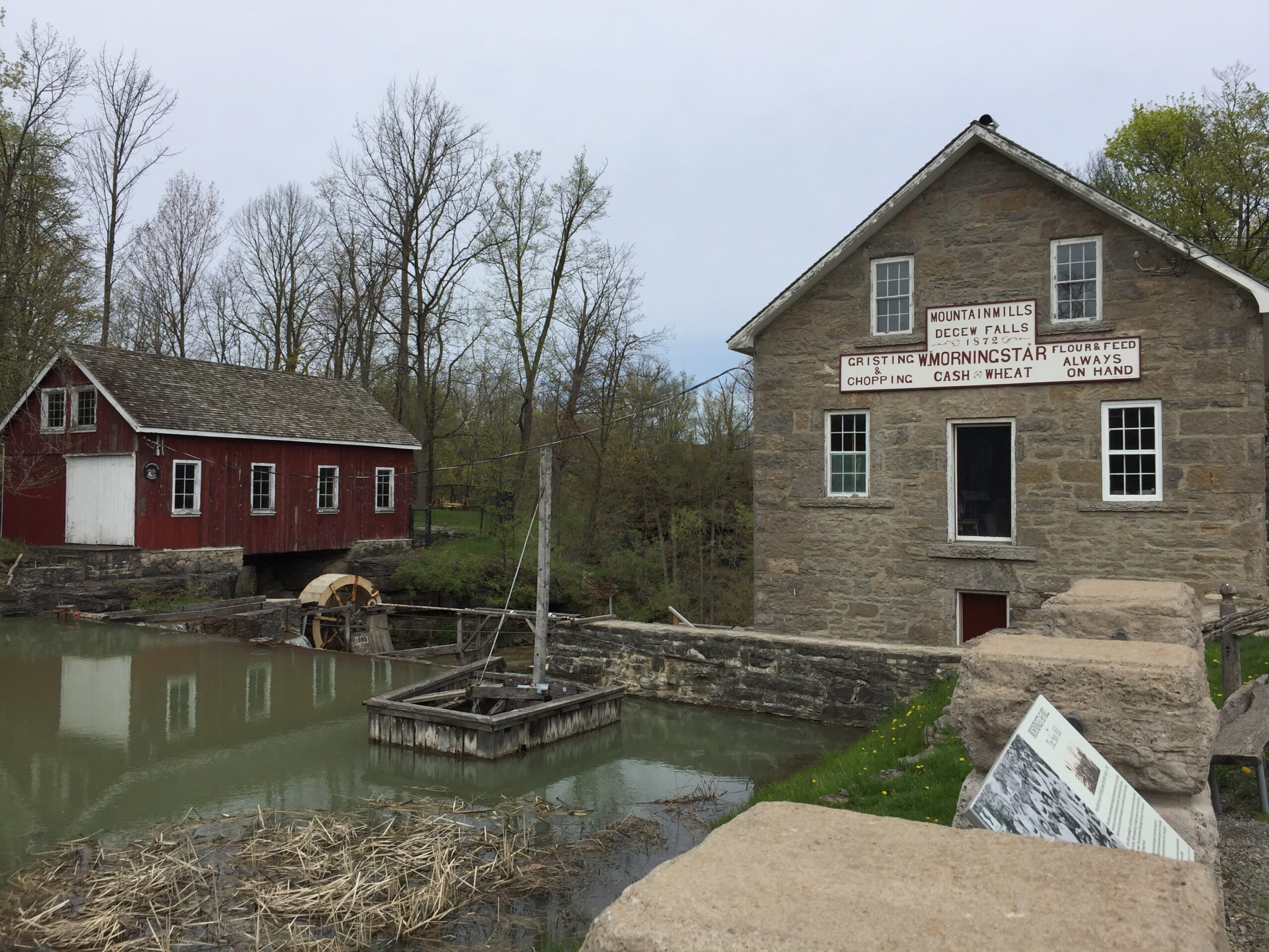
10:00 Decew to Morningstar Mill
https://hikes.brucetrail.org/event/1000-decew-to-morningstar-mill-3/Sorry, the registration cut-off time for this hike has been reached.Not a member? Click here to join today!Hosting Club: Niagara
Category: In and Out
Location (Google Maps): Decew house West of Merritt Road.Hike Leader(s): Sylvia Wheeler Click here to contact Hike Leader(s)
Pace: Medium
Terrain: Moderate
Distance: 8 kmDescription
Exploring Sydenham hikes 10 & 11
https://hikes.brucetrail.org/event/exploring-sydenham-hikes-10-11/Sorry, the registration cut-off time for this hike has been reached.Not a member? Click here to join today!Hosting Club: Sydenham
Category: General Hike
Location (Google Maps):Meet in the north-east corner of the parking lot at Home Depot on Highway 26 on the east side of Owen Sound.
Hike Leader(s): Bill Snel Click here to contact Hike Leader(s)
Pace: Leisurely: 3 km/h or less
Terrain: Moderate: Some hills and/or poor footing
Distance: 4 kmDescription
We will carpool to do a loop hike of 2 trails. This will be hikes 10 & 11 in the book Exploring Sydenham. There will be one secret to find. If you do not have a book and would like one ($30) let me know by using the “Contact hike leader” link. - 08July 8, 2024
Limehouse Loop Hike
https://hikes.brucetrail.org/event/limehouse-loop-hike-3/Sorry, the registration cut-off time for this hike has been reached.Not a member? Click here to join today!Hosting Club: Iroquoia
Category: General Hike
Location (Google Maps):Limehouse Parking Lot
Hike Leader(s): Pati Greenwood, Jeff Dowsett Click here to contact Hike Leader(s)
Pace: Medium – 3 to 4 km/hr
Terrain: Moderate – Some hills and/or some poor footing
Distance: 15 kmDescription
Starting at the Limehouse Parking Lot, the hike will follow the main trail, the Canada Goose Side Trail, the Ridge Side Trail and the Todd Bardes Meadowland Side Trail to form at 15 km loop. There will be regular breaks, including a lunch stop along the way. Bring snacks, a lunch and plenty of water. Insect repellent is recommended. Please arrive at 8:15 am as we will depart promptly at 8:30 am.
- 09July 9, 2024
8:00 Long Hike Wiley Road Short Hills
https://hikes.brucetrail.org/event/800-long-hike-wiley-road-short-hills-44/Sorry, the registration cut-off time for this hike has been reached.Not a member? Click here to join today!Hosting Club: Niagara
Location (Google Maps):
Short Hills Wiley Road Entrance
Pace: Medium
Terrain: Moderate
: 10kmDescription
Explore Short Hills and the majestic side trails of Scarlett Tanager, Hemlock. Swayze Falls and Terrace. Register for each hikeBring Poles, Sunscreen, bug spray water, snack, and dress for the weather
9:15 Short Hike - Short Hills Park, Pelham Rd
https://hikes.brucetrail.org/event/915-short-hike-short-hills-park-pelham-rd-8/Sorry, the registration cut-off time for this hike has been reached.Not a member? Click here to join today!Hosting Club: Niagara
Category: In and Out
Location (Google Maps): Shorthills Provincial Park, Pelham RdHike Leader(s): Debbie Demizio Click here to contact Hike Leader(s)
Pace: Medium
Terrain: Moderate
Distance: 7 kmsDescription
This hike will be about 30 mins longer than the usual Short hike at Shorthills. We’ll be hiking to Morningstar Mill and back.Mono Centre North & South Loop Hike
https://hikes.brucetrail.org/event/mono-centre-north-south-loop-hike/Sorry, the registration cut-off time for this hike has been reached.Not a member? Click here to join today!Hosting Club: Caledon Hills
Category: Tuesday Hikers
Location (Google Maps): Take Hwy 10 north of Orangeville about 4-5 km to Camilla, aka the Mono Centre Road, turn east and continue on this road until you reach Mono Centre. Start at Mono Community Centre parking Lot, west of km 72.2, 200 m south of Mono Centre.Hike Leader(s): Jim Garrow Click here to contact Hike Leader(s)
Pace: Medium – 3 to 4 km/hour
Terrain: Easy – mostly flat and usually good footing
Distance: Approx. 8 kmDescription
Hike will start at Mono Community Centre on the main Bruce Trail south to the Turnbull, Springwater, and Whitetail Refuge Side Trails, then north on 3rd Line a short distance to South Outlier Loop Side Trail returning to Mono Community Centre on the main Bruce Trail. Bring water and snacks. No dogs please. - 10July 10, 2024
Bibbulmun Friendship Trail
https://hikes.brucetrail.org/event/bibbulmun-friendship-trail-3/Sorry, the registration cut-off time for this hike has been reached.Not a member? Click here to join today!Hosting Club: Blue Mountains
Category: Register in person the morning of hike.
Location (Google Maps): Hike meets in the parking lot behind Tim Hortons on First St. in Collingwood.Hike Leader(s): Mary-Lynn Chenard Click here to contact Hike Leader(s)
Pace: Medium – 3 to 4 km/hr
Terrain: Moderate – Some hills and/or some poor footing
Distance: 7 kmDescription
This is one of our Friendship trails running along BTC trails and other conserved land north of Boyne Valley Provincial Park. We will park at km 29.4 on 1st Line E in the Dufferin Hi-Land section. The 7 km figure eight hike will follow the white blazed trail to km 25.4, looping back to the parking lot via the Oliver Creek Side Trail and the Moss Haven Side Trail. Bring a lunch or snack and water. *The Bibbulmun Track in Western Australia stretches 1,000 km from Kalamunda in the Perth Hills to the historic town of Albany on the south coast.9:15 Enjoy the Flora around The Falls
https://hikes.brucetrail.org/event/915-enjoy-the-flora-around-the-falls/Sorry, the registration cut-off time for this hike has been reached.Not a member? Click here to join today!Hosting Club: Niagara
Category: In and Out
Location (Google Maps):Dufferin Islands parking lot, off Burning Springs Hill, Niagara Falls. Note: a parking fee applies, as part of the Niagara Falls Parkway parking system.
Hike Leader(s): Karen Couch Click here to contact Hike Leader(s)
Pace: Medium
Terrain: Easy
Distance: 6-8 kmsDescription
Experience the flora in the Dufferin Islands Nature Area, Oakes Garden Theatre and in between along the Niagara Parkway. With luck the roses will be in full bloom in the Victoria Parks’ garden.WEDNESDAY WALKERS - Around Eugenia CANCELLED due to rain
https://hikes.brucetrail.org/event/wednesday-walkers-around-eugenia-2/Sorry, the registration cut-off time for this hike has been reached.Not a member? Click here to join today!Hosting Club: Beaver Valley
Location (Google Maps): Meet at the end of North Street in Eugenia. Km 56.1, map 26, Edition 31. Park on the south side of the street facing east.
Hike Leader(s): Glenda Collings Click here to contact the hike leader.
Pace: Medium
Terrain: Moderate, Some steep sections
Length of Hike: 5.8 kmDescription
This hike route quickly enters a wooded area on Valley slope. There will be plenty of up-and-down walking until we reach Eugenia Falls Conservation Area. This is a scenic section of Trail, walking along the side of the Beaver River, crossing the river and walking along more riverside. There are old structures still in place that show some of the early history of development in the area. Hikers will see a good view of the high Eugenia Falls. This hike is a there-and-back route.COVID-19 Precautions Before, During and After your Hike
- Each hiker joining a Bruce Trail Club organized hike must perform a self-screening check before hiking.
Find Ontario’s self-assessment tool here: https://covid-19.ontario.ca/self-assessment/ - If you are experiencing COVID-19 symptoms, stay home.
Other Guidelines
- Arrive 15 minutes before the start of the hike.
- Wear sturdy footwear and appropriate attire for the weather and the terrain.
Hiking poles are a good idea in any season, especially if the terrain is rocky or slippery. In winter, snowshoes or icers/crampons are needed when conditions dictate.
Wearing appropriate clothing and footwear prevents injuries and shows consideration for a safe and positive group hiking experience. - Always carry I.D. and your health card.
- Bring sufficient water and snacks (or lunch if indicated). A minimum of 1L of water is recommended on all hikes, and 3L is recommended for long, challenging hikes in the heat of the summer.
- Bring sunscreen and insect repellent (for spring and summer hikes).
- Bring your own first aid kit.
- Please leave dogs at home.
- Each hiker joining a Bruce Trail Club organized hike must perform a self-screening check before hiking.
- 11July 11, 2024
8:00 am Long Hike Jordan to Moyer / Louth
https://hikes.brucetrail.org/event/800-am-long-hike-jordan-to-moyer-louth-70/Sorry, the registration cut-off time for this hike has been reached.Not a member? Click here to join today!Hosting Club: Niagara
Location (Google Maps):
Jordan Hollow Park 3039 King St Jordan
Pace: Medium
Terrain: Moderate
: 10kDescription
From Jordan Hollow Hike the main trail to Upper and Lower Balls Falls, Moyer Road or Louth and Return. You must register for each hike. Bring Poles, sunscreen, bug spray , snack and a drink and dress for the weatherHiking in and around Jordan
https://hikes.brucetrail.org/event/hiking-in-and-around-jordan-2/Sorry, the registration cut-off time for this hike has been reached.Not a member? Click here to join today!Hosting Club: Niagara
Location (Google Maps): Sho’arishon Park, formerly Jordan Hollow Park, Jordan
Hike Leader(s): Bill Russell Click here to contact Hike Leader(s)
Pace: Medium
Terrain: Strenuous
Distance: 7 kmDescription
Hike the main road and side trails around Jordan. Wear hiking boots and bring water, sunscreen and bug spray.Caledon Hills End-to-End Hike 2 of 6
https://hikes.brucetrail.org/event/caledon-hills-end-to-end-hike-2-of-6/Sorry, the registration cut-off time for this hike has been reached.Not a member? Click here to join today!Hosting Club: Caledon Hills
Category: End-to-End
Location (Google Maps): Meet at Mono 5 Sideroad parking, km 45.4, where the trail crosses. Shuttle to start at Hockley Rd.Hike Leader(s): Nancy Mooney Click here to contact Hike Leader(s)
Pace: Medium – 3 to 4 km/hour
Terrain: Moderate – some hills and/or some poor footing, Strenuous – hilly with steep climbs and some poor footing
Distance: 61.1 – 45.4 + 0.250 from parking = 16 km totalDescription
This is the second hike in the series and takes us through the Hockley Valley Resort, pine plantations, hills and valleys. ***Please bring more than enough water for a long July hike!
Rattlesnake Loop
https://hikes.brucetrail.org/event/rattlesnake-loop/Sorry, the registration cut-off time for this hike has been reached.Not a member? Click here to join today!Hosting Club: Iroquoia
Category: Thursday Group
Location (Google Maps): Rattlesnake Conservation AreaHike Leader(s): Anne Armstrong Click here to contact Hike Leader(s)
Pace: Leisurely – 3km/hr or less
Terrain: Moderate – Some hills and/or some poor footing
Distance: Approx. 9 km.Description
Please join us as we hike this beautiful area with views from the top of the escarpment and from the bottom of Nassagaweya Canyon looking up to the escarpment. The forest will be lush and green and cool. Meet in the lower parking lot at 9:15 for a 9:30 am. start. Bring water, a snack, insect repellent and sunscreen. Hiking poles will be useful. Make a reservation with Halton Parks to enter the conservation.
please contact hike leader via this form if you have any questions. - 12July 12, 2024
Scotsdale Farm - Silver Creek
https://hikes.brucetrail.org/event/scotsdale-farm-silver-creek-3/Sorry, the registration cut-off time for this hike has been reached.Not a member? Click here to join today!Hosting Club: Iroquoia
Category: General Hike
Location (Google Maps):Scotsdale Farm Parking Lot
Hike Leader(s): Pati Greenwood, Jeff Dowsett Click here to contact Hike Leader(s)
Pace: Medium – 3 to 4 km/hr
Terrain: Moderate – Some hills and/or some poor footing
Distance: 14 kmDescription
From Scotsdale Farm parking lot, we will hike the main trail and side trails in Silver Creek Conservation area for a 14k loop. Bring a snack and plenty of water. Wear sturdy footwear and clothing appropriate to conditions. Insect repellent is recommended.Please arrive at 8:15 am as well will leave promptly at 8:30 am.

Niagara-on-the-Lake Tour
https://hikes.brucetrail.org/event/niagara-on-the-lake-tour-56/Sorry, the registration cut-off time for this hike has been reached.Not a member? Click here to join today!Hosting Club: Niagara
Category: Urban
Location (Google Maps): Park on King St near Center St, just outside of Veterans Memorial Park, Niagara-on-the-LakeHike Leader(s): Margaret Northfield Click here to contact Hike Leader(s)
Pace: Medium
Terrain: Easy
Distance: 6-7kmDescription
Each Friday we will explore different neighbourhoods, trails and parkland throughout Historic Niagara-on-the-Lake.Moderate pace with some weeks entirely on sidewalks and roads while others may include a mix of trails and paved pathways. Great way to build up endurance for longer more strenuous hikes.
Prepare for cooler windy conditions on open parkland and along Lake Ontario and Niagara River trails.
Plan to stay for conversation and a warm cup of coffee or tea at Sweets & Swirls, Community Centre, Niagara Stone Road, NOTL
Robin & Margaret

Afternoon hike - Halton Agreement Forest
https://hikes.brucetrail.org/event/afternoon-hike-halton-agreement-forest/Sorry, the registration cut-off time for this hike has been reached.Not a member? Click here to join today!Hosting Club: Iroquoia
Category: Afternoon/Evening Hikes
Location (Google Maps): Meet roadside on 4th Line. Up Guelph Line from the 401, turn right on 10 Side Road and follow the curve as it becomes 4th Line.Hike Leader(s): Karen Bergmann Click here to contact Hike Leader(s)
Pace: Medium – 3 to 4 km/hr
Terrain: Moderate – Some hills and/or some poor footing
Distance: 6 kmsDescription
We will hike around the bike trails in this lovely Forest. The bugs will be active, so bring bug spray/bug net. - 13July 13, 2024

New Badge! Niagara E2E Hike #3
https://hikes.brucetrail.org/event/new-badge-niagara-e2e-hike-3/Sorry, the registration cut-off time for this hike has been reached.Not a member? Click here to join today!Hike open to BTC Members only.
Hosting Club: Niagara
Category: Car Pool
Location (Google Maps): Meet at Decew House Parking lot ( Map 3) N 43.107568 W79.249598
Carpool back to Louth Conservation AreaHike Leader(s): Lauren Doig Click here to contact Hike Leader(s)
Pace: Medium
Terrain: Strenuous
Distance: 21.5Description
This is the longest hike in the series . Be sure to bring snacks and enough water and electrolytes. Poles are recommended. Be prepared for the weather.Car Hike: Rouge National Park Scarborough
https://hikes.brucetrail.org/event/car-hike-rouge-national-park-scarborough-3/Sorry, the registration cut-off time for this hike has been reached.Not a member? Click here to join today!Hosting Club: Toronto
Location (Google Maps): Rouge Park, Zoo Road Parking Lot, off Meadowvale Road north of Sheppard Ave
Hike Leader(s): Mohammad Aghamiri Click here to contact Hike Leader(s)
Pace: Moderate
Terrain: Hilly, Variable
Distance: 14-17 kmDescription
Will explore Toronto part of Rouge park along Rouge river and Little Rouge Creek,Some safety procedures during the hike:
1-Hikers must stay between the leader and the sweep.
2-Hikers must advise the leader or the sweep if they wish to leave the group.
3- Hikers must follow the whistle instructions: 1 blast- stay where you are; 2 blasts come to the leader; 3 blasts – come to the leader quickly.
4-Hike leader may request volunteers to stop at trail intersections, they need to help hikers to the direction the group walk and wait till they see the sweep .
5-Hikers have to make sure they can see the persons behind and in front of them.
Bus Hike: Caledon E2E Hike #4 of 5
https://hikes.brucetrail.org/event/bus-hike-caledon-e2e-hike-4-of-5/Sorry, the registration cut-off time for this hike has been reached.Not a member? Click here to join today!Trip Information
Departure Time: 08:30
Return to City Time: 17:00
Departure Point: Kipling Departure PointOptional Items
Hosting Club: Toronto, Caledon Hills
Category: Bus Hike
Location (Google Maps): 5 Sideroad, MonoHike Leader(s): Sajedeh Zahraei; Celia Ho Click here to contact Hike Leader(s)
Pace: Moderate
Terrain: Variable
Distance: 15.7 KmDescription
Maps 18, km 44.3 – km 60.1 (15.8 km)
Starting Point: Parking Area – Mono 5 Sideroad – km 44.3 (on the north side of the road where the Trail crosses) (43.974055°N 79.984988°W)
Drop-out Point: Roadside Parking – km 53.9 (on 4th Line EHS at the entrance to the Peter Beecham Side Trail) (43.976327°N 80.026621°W)
End Point: Hockley Road Parking Area – km 60.1 (located on the north side of Hockley Rd at the Hockley Road Side Trail) (43.972857°N 80.056330°W)
8:30am Niagara Shores Park Beachcoming Hike
https://hikes.brucetrail.org/event/830am-niagara-shores-park-beachcoming-hike/Sorry, the registration cut-off time for this hike has been reached.Not a member? Click here to join today!Hike open to BTC Members only.
Hosting Club: Niagara
Category: Loop
Location (Google Maps):Corner of Niven Road and Lakeshore Road in Niagara-on-the-Lake. Park along Old Lakeshore Road.
Hike Leader(s): Suzanne Gourluck Click here to contact Hike Leader(s)
Pace: Leisurely
Terrain: Moderate
Distance: 5-6kmDescription
Explore a lakeshore park, shoreline and cliff top trail in Niagara-on-the-Lake. This beachcombing hike involves uneven ground, clambouring over fallen trees, a pebbly beach, sandy, wet and exposed areas. Hat, sunscreen and poles are highly recommended. Please note: This is not a maintained trail and some areas may have overhanging grass and shrubs.
Bus Hike: Hike & Winery Tour and Tasting - Niagara Section - Balls Falls/Louth Conservation Areas
https://hikes.brucetrail.org/event/bus-hike-hike-winery-tour-and-tasting-niagara-section-balls-falls-louth-conservation-areas/Sorry, the registration cut-off time for this hike has been reached.Not a member? Click here to join today!Trip Information
Departure Time: 08:30
Return to City Time: 18:00
Departure Point: Kipling Departure PointOptional Items
Hosting Club: Toronto
Category: Bus Hike
Location (Google Maps): Niagara Section- Balls Fall, Louth and Rockway Conservation AreasHike Leader(s): Ross Estrella, Tom Swales Click here to contact Hike Leader(s)
Pace: Moderate
Terrain: Hilly, Rocky, Variable
Distance: 10 kmsDescription
We’ll hike the main trail for 10 km from Balls Falls Conservation Area to Rockway Conservation Area at a moderate pace (3.5 km/hour) while enjoying the beauty of the Niagara Escarpment (Hike4Heath-Hike4Fun). Don’t forget to bring snacks, a lunch, and sufficient water for hydration. Also bring sunscreen, sun protection, a full brimmed hat, and insect repellent in the event that we’re welcomed by friendly mosquitoes. Sturdy comfortable hiking boots/shoes and poles are highly recommended. Dress according to the expected weather conditions as per the weather forecast. There will be no dropouts. From the finish of our hike the bus will take us to Pillitteri Estates Winery where we’ll experience and enjoy a private structured wine tasting and tour hosted by one or more of the knowledgeable and friendly staff. The cost of the tasting and tour experience is $16.95 ($15.00 + HST) per person with four wines selected by the host. Please bring the fee for the tour/tasting in exact cash as it will be collected on the bus to simplify the payment to the winery estate upon our arrival. You may purchase a bottle of your favorite vino and souvenirs, if offered. If interested in attending this hike please register early (by July 7th) so the number of people expected in our group can be provided to the winery a few days in advance. Your cooperation would be appreciated.
Summer Fen Series: Oliphant Fen & Petrel Point
https://hikes.brucetrail.org/event/summer-fen-series-oliphant-fen-petrel-point-3/Sorry, the registration cut-off time for this hike has been reached.Not a member? Click here to join today!Hike open to BTC Members only.
Hosting Club: Sydenham, Peninsula
Category: Botany Hike
Location (Google Maps): Oliphant Fen – by North Entrance to Lorraine Brown BoardwalkHike Leader(s): Jeannine Kralt Click here to contact Hike Leader(s)
Pace: Leisurely: 3 km/h or less
Terrain: Easy: Mostly flat and good footing.
Distance: 3kmDescription
Join the Sydenham and Peninsula Bruce Trail Clubs for a hike series focusing on fens. Fens are unique coastal wetlands occurring along the escarpment, meadow marshes that have conditions that are favourable for a variety of interesting species including orchids.This easy hiking series will begin at Oliphant Fen, with a participant carpool to Petrel Point, returning to Oliphant thereafter. Observations count towards the PBTC Orchid Badge.
Come to one of the hikes or several to see how the fens change through the seasons. Carpooling encouraged – contact the hike leader if you are in need of a ride (no guarantees, but attempts will be made to help coordinate). Please plan to arrive 15 minutes in advance of the hike start time.
Please contact Jeannine, the hike leader, if you have any questions or concerns (link on this page).
Pine River
https://hikes.brucetrail.org/event/pine-river-3/Sorry, the registration cut-off time for this hike has been reached.Not a member? Click here to join today!Hosting Club: Blue Mountains
Category: Register in person the morning of hike.
Location (Google Maps): Hike meets in the parking lot behind Tim Hortons on First St. in Collingwood.Hike Leader(s): Michael Treuman Click here to contact Hike Leader(s)
Pace: Leisurely – 3 km/hr. or less
Terrain: Moderate – Some hills and/or some poor footing
Distance: 7 kmDescription
We will drive to Kilgorie in the Dufferin Hi-Land section and park the cars at km 34.9 on Centre Road. From here, we will hike a figure eight loop utilizing the white blazed trail, the new Pine River Valley Side Trail and the Kilgorie Side Trail. This hike boasts a wonderful view from the Bell Tower Side Trail, ruins of an old powerhouse, the stunning Pine River, lake views, ponds, and more! The ruins of the old powerhouse along the Pine River are almost all that remain of the Dufferin Light and Power Company. Nearby is the old flume that brought water from a dam, which was constructed in 1909 and was the largest of its kind in Ontario. The plant provided power until 1923. Bring a snack or lunch and water.