Hike Schedule
Join us for a hike! Registration required.
All hikes available to BTC members. Some hikes are open to non-members.
See Refund Policy for Paid Hikes >
TIP: The calendar view displays up to 7 hikes on a day, but often there are more. Click “View more events” to see them all.
Categories
- 09June 9, 2024

Blue Mountain End to End in 3 Hikes ~ Stained Glass Fundraiser Badge
https://hikes.brucetrail.org/event/blue-mountain-end-to-end-in-3-hikes-stained-glass-fundraiser-badge/Sorry, the registration cut-off time for this hike has been reached.Not a member? Click here to join today!Hike open to BTC Members only.
This is a Multi-Day Hike
You are signing up for the following dates and times:
2024-06-09 at 07:00
2024-06-23 at 07:00
2024-07-14 at 07:00Hosting Club: Blue Mountains, Sydenham
Category: General Hike
Location (Google Maps):Hike Leader(s): Margaret O’Dell Click here to contact Hike Leader(s)
Pace: Brisk: 4 to 5 km/h, Fast: more than 5 km/h
Terrain: Strenuous: Hilly with steep climbs and some poor footing.
Distance: 22.8 kmDescription
This series of hikes is a Fundraiser series for the Blue Mountains Bruce Trail Club. All proceeds fund the activities of the Club directly. You are signing up for all 3 hikes, and must be present for all the hikes to receive the special fundraising badge.Hikers will receive a schedule of the Itinerary for all 3 hikes upon registration. Each Hike is 22-23 Km. The GPS coordinates for Hike on Day #1 are provided here. We will be starting the hike from Maple Lane, at the Blue Mountains Beaver Valley Boundary
- This hike series is intended for experienced distance hikers only; hikes will be lead at a brisk to fast pace. Be aware of your ability to join this series.
- Hikes will average 4.5 km per hour including breaks, moving pace is 5 km per hour;
- Expect to be on-trail for 4-5 hours;
- Meeting time is scheduled for 7:00am so that we’re on the trail at the earliest part of the day and avoid the heat in the afternoons;
- You must arrive no later than 15 minutes prior to the meeting time to organize shuttle; all participants will be expected to participate in the shuttle;
- Any applicable parking fees will be shared within the group.
- Hikers must carry sufficient hydration, accessible snacks, small lunch, first-aid kit, rain gear, extra socks, bug spray, etc; Check the weather as you pack your gear;
- If you have any questions or concerns, please use the Contact the Hike Leader above.
Sydenham Series #4 - Woodford to Bayview Escarpment
https://hikes.brucetrail.org/event/sydenham-series-4-woodford-to-bayview-escarpment/Sorry, the registration cut-off time for this hike has been reached.Not a member? Click here to join today!Hosting Club: Dufferin Hi-Land, Sydenham
Category: General Hike
Location (Google Maps): Roadside parking along the St. Vincent-Sydenham Townline at the field entrance of the River Kwai Side Trail. (We will not be building a bridge!). 44.624492, 80.730579. Please arrive at 8:45 am to be ready to shuttle at 9:00 am.Hike Leader(s): Stuart Law Click here to contact Hike Leader(s)
Pace: Medium
Terrain: Slippery and Steep Sections, Slippery Sections Likely, Strenuous
Distance: 16 kmsDescription
Join us on the fourth of our 10 Sydenham E2E Series shuttle hikes. Peaceful rural Ontario notwithstanding the fact we will take in the new Kaboom Side Trail. Woods. Rocky technical terrain. May have to cross a swollen creek. Please bring a garbage bag and a change of footwear for the shuttle (we will be very muddy) and please be prepared to drive fellow hikers before or after the hike. Please bring a smile, 2L of water, a warm drink, sunblock, a snack and a lunch. It’s a touch early for bugs but be ready for them too just in case. Hiking boots mandatory. Poles and gaiters recommended. Please arrive at 8:45 am to be prepared to shuttle at 9:00 am sharp. Please visit the BTC website to see what should be in your back pack including your own first aid kit, an extra pair of socks and plastic bags to wear over your feet inside your boots in case you get a footer.Guided Mushroom/Fungi Educational Hike
https://hikes.brucetrail.org/event/guided-mushroom-fungi-educational-hike-2/Sorry, the registration cut-off time for this hike has been reached.Not a member? Click here to join today!Hosting Club: Beaver Valley
Location (Google Maps): Meet in the Johnston’s Side Road BTC parking area, km 71.7, Map 26, Edition 31. Please be there 15 minutes before the hike start time.
Hike Leader(s): Glenda Collings Click here to contact the hike leader.
Pace: Leisurely
Terrain: Moderate, Some steep sections
Length of Hike: Approx. 1 1/2 hoursDescription
Excited about fungi? Join us for an educational hike led by an expert in the field from the The Mycological Society of Toronto. As we walk slowly along the trail, we will be viewing and learning about a variety of mushrooms/fungi. If you are thinking about working towards earning our Mushroom Hunter badge, see https://beavervalleybrucetrail.org/earning-badges/ one of our leaders will take photos, do I.D. and send that info to interested participants, just to keep us moving along. Please be dressed for the weather and bring water.COVID-19 Precautions Before, During and After your Hike
- Each hiker joining a Bruce Trail Club organized hike must perform a self-screening check before hiking.
Find Ontario’s self-assessment tool here: https://covid-19.ontario.ca/self-assessment/ - If you are experiencing COVID-19 symptoms, stay home.
Other Guidelines
- Arrive 15 minutes before the start of the hike.
- Wear sturdy footwear and appropriate attire for the weather and the terrain.
Hiking poles are a good idea in any season, especially if the terrain is rocky or slippery. In winter, snowshoes or icers/crampons are needed when conditions dictate.
Wearing appropriate clothing and footwear prevents injuries and shows consideration for a safe and positive group hiking experience. - Always carry I.D. and your health card.
- Bring sufficient water and snacks (or lunch if indicated). A minimum of 1L of water is recommended on all hikes, and 3L is recommended for long, challenging hikes in the heat of the summer.
- Bring sunscreen and insect repellent (for spring and summer hikes).
- Bring your own first aid kit.
- Please leave dogs at home.

Urban Walk: Whitby to Oshawa
https://hikes.brucetrail.org/event/urban-walk-whitby-to-oshawa-3/Sorry, the registration cut-off time for this hike has been reached.Not a member? Click here to join today!Hosting Club: Toronto
Category: Urban Walk
Location (Google Maps): Whitby, OntarioHike Leader(s): Brian Rideout Click here to contact Hike Leader(s)
Pace: Moderate
Terrain: Flat
Distance: 10 kmDescription
Please join me under the clock in the Great Hall of Union Station by 9:05 am. We will take the eastbound Lakeshore train departing 9:20 AM, arriving in Whitby at 10:13 AM. If you prefer to drive, please meet at the north entrance of Whitby Go Station near the washrooms and the ticket counter.Please check out the GO Transit website and consider purchasing a one day pass for $10.
We will hike south to the lake and east to Oshawa along the Waterfront Trail for an estimated distance of 10 km. We will pass through several parks in Whitby and Oshawa along the way.While in Oshawa we will take Durham Region Transit to the Fox and the Goose pub and to Oshawa GO so please bring your Presto card and / or cash fare. Please bring sun screen, bug spray, a light snack and at least 2 liters of water.
Here is a map of our route: Whitby to Oshawa
Guided Mushroom/Fungi Educational Hike
https://hikes.brucetrail.org/event/guided-mushroom-fungi-educational-hike/Sorry, the registration cut-off time for this hike has been reached.Not a member? Click here to join today!Hosting Club: Beaver Valley
Location (Google Maps): Meet in the Johnston’s Side Road BTC parking area, km 71.7, Map 26, Edition 31. Please be there 15 minutes before the hike start time.
Hike Leader(s): Glenda Collings Click here to contact the hike leader.
Pace: Leisurely
Terrain: Moderate, Some steep sections
Length of Hike: Approx. 1 1/2 hoursDescription
Excited about fungi? Join us for an educational hike led by an expert in the field from the The Mycological Society of Toronto. As we walk slowly along the trail, we will be viewing and learning about a variety of mushrooms/fungi. If you are thinking about working towards earning our Mushroom Hunter badge, see https://beavervalleybrucetrail.org/earning-badges/ one of our leaders will take photos, do I.D. and send that info to interested participants, just to keep us moving along. Please be dressed for the weather and bring water.COVID-19 Precautions Before, During and After your Hike
- Each hiker joining a Bruce Trail Club organized hike must perform a self-screening check before hiking.
Find Ontario’s self-assessment tool here: https://covid-19.ontario.ca/self-assessment/ - If you are experiencing COVID-19 symptoms, stay home.
Other Guidelines
- Arrive 15 minutes before the start of the hike.
- Wear sturdy footwear and appropriate attire for the weather and the terrain.
Hiking poles are a good idea in any season, especially if the terrain is rocky or slippery. In winter, snowshoes or icers/crampons are needed when conditions dictate.
Wearing appropriate clothing and footwear prevents injuries and shows consideration for a safe and positive group hiking experience. - Always carry I.D. and your health card.
- Bring sufficient water and snacks (or lunch if indicated). A minimum of 1L of water is recommended on all hikes, and 3L is recommended for long, challenging hikes in the heat of the summer.
- Bring sunscreen and insect repellent (for spring and summer hikes).
- Bring your own first aid kit.
- Please leave dogs at home.
Exploring Sydenham hike 7
https://hikes.brucetrail.org/event/exploring-sydenham-hike-7/Sorry, the registration cut-off time for this hike has been reached.Not a member? Click here to join today!Hosting Club: Sydenham
Category: General Hike
Location (Google Maps):Meet in the north-east corner of the parking lot at Home Depot on Highway 26 on the east side of Owen Sound.
Hike Leader(s): Bill Snel Click here to contact Hike Leader(s)
Pace: Leisurely: 3 km/h or less
Terrain: Moderate: Some hills and/or poor footing, Strenuous: Hilly with steep climbs and some poor footing.
Distance: 6.4 kmDescription
We will carpool to do a loop hike of some Silent Valley trails. This is hike 7 in the book Exploring Sydenham. It has a secret to be located. - 10June 10, 2024

Sydenham E2E Stained Glass Fundraising Series in 8 Hikes
https://hikes.brucetrail.org/event/sydenham-e2e-stained-glass-fundraising-series-in-8-hikes/Sorry, the registration cut-off time for this hike has been reached.Not a member? Click here to join today!Hike open to BTC Members only.
This is a Multi-Day Hike
You are signing up for the following dates and times:
2024-06-10 at 08:00
2024-06-11 at 08:00
2024-06-12 at 08:00
2024-06-13 at 08:00
2024-06-17 at 08:00
2024-06-18 at 08:00
2024-06-19 at 08:00
2024-06-20 at 08:00Hosting Club: Toronto, Sydenham
Category: Car Hike
Location (Google Maps): Km 20.7, on the shoulders of 6th Concession S. GPS N44.507399, W80.810098Hike Leader(s): Jacquie Van Dyke
Pace: Brisk, Moderate
Terrain: Hilly, Variable
Distance: Distances will be approximately 20-25km per day, spread over 8 hikes, for a total of 175km.Description
This Sydenham Stained Glass E2E Fundraising hike series will be spread over 8 days, covering approximately 175km. The funds paid will be collected by the Toronto Bruce Trail Club and transferred to the Sydenham Club to help with the club’s expenses and the pledge of maintaining “The Ribbon of Wilderness for Everyone Forever.” The registration date of March 3 at 9:00pm is for all 8 group hikes. Participants completing this series will receive the Hart’s Tongue Fern badge (designed by Joe Borges) at the end of the last hike. Life aside from hiking does happen and you may miss 2 hikes but please let the hike leader know ahead of time and make it up before June 20, 2024.A hike schedule will be sent late-May to all participants. Hikes will range in distance of 20-25km, hiking at an average speed of 3-5km/hour, depending on trail & weather conditions.
Please arrive by 8:00am for each hike to get organized and to be ready to begin the car shuttle at 8:15. All hikers are expected to participate fairly in the car shuttles. No dropout points have been established and therefore hikers who must drop out, will be responsible for their own transportation back to their vehicle. Please note: available transportation back to your vehicle is very limited in this section. It’s going to get warm/hot so please be prepared with enough food to last the hike, a minimum of 2L of hydration, bug repellent, and hiking gear appropriate for the weather/conditions. We’ll have a short morning break and also a lunch break on each hike.
Dundas Valley Conservation Area
https://hikes.brucetrail.org/event/dundas-valley-conservation-area-9/Sorry, the registration cut-off time for this hike has been reached.Not a member? Click here to join today!Hosting Club: Iroquoia
Category: General Hike
Location (Google Maps):Dundas Valley Conservation’s Area
Hike Leader(s): Pati Greenwood, Jeff Dowsett Click here to contact Hike Leader(s)
Pace: Medium – 3 to 4 km/hr
Terrain: Moderate – Some hills and/or some poor footing
Distance: 10 kmDescription
We will hike through the Dundas Valley Conservation Area on the main Bruce Trail, Conservation trails and BT side trails. Bring water and snacks. Be sure to wear appropriate clothing and footwear.Park in the main Parking lot located at 650 Governor’s Road. Parking fees will be required. See the Hamilton Conservation Authority for more information: https://conservationhamilton.ca/admissions-fees/
Please arrive at 8:15 am as we will leave promptly at 8:30 am.

Spring Birds and Blooms
https://hikes.brucetrail.org/event/spring-birds-and-blooms-2/Sorry, the registration cut-off time for this hike has been reached.Not a member? Click here to join today!Hike open to BTC Members only.
Hosting Club: Peninsula
Category: Birding
Location (Google Maps): Meet at the parking lot at the intersection of Highway 6 and Dyers Bay Road at 8:30 a.m. We will car pool to the Cottrill Lake ST parking area to begin our hike.Hike Leader(s): Marg Glendon Click here to contact Hike Leader(s)
Pace: Fast, Leisurely, Medium
Terrain: Moderate
Distance: ~3 1/2 KMDescription
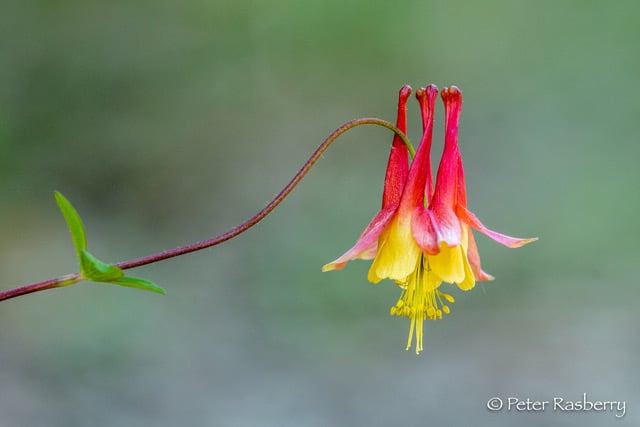
Join Bird Enthusiast – Peter Rasberry – for a Spring Birds and Blooms hike on the Cottrill Lake Side Trail. This should be peak time for both spring wildflowers and bird migration. The hike pace is slow and will be a “walk, stop and talk” type of hike. This provides an opportunity to identify and appreciate all that nature is offering us! The terrain is rocky but relatively flat on Cottrill Lake Side Trail. At the end of Cottrill Lake Side Trail, we will decide as a group, whether we return to our starting point by walking on Britain Lake Road, or hiking the more rugged terrain with lots of “ups and downs” on the Anne and Clayton Roberts Side Trail to the Main Trail. Both options complete the loop at the Cottrill Side Trail parking area. Distance for both options is about the same ~ 3 ½ km. Dress according to the weather. Bring snacks, water, cameras, binoculars, field guides, and insect repellent. Hike finish should be about 11:30 a.m.Map 40. Bruce Trail Reference Guide Edition 31
- 11June 11, 2024
NEW TIME 8:00 Long Hike Wiley Road Short Hills
https://hikes.brucetrail.org/event/new-time-800-long-hike-wiley-road-short-hills-6/Sorry, the registration cut-off time for this hike has been reached.Not a member? Click here to join today!Hosting Club: Niagara
Location (Google Maps):
Short Hills Wiley Road Entrance
Hike Leader(s): Alan Laver Click here to contact Hike Leader(s)
Pace: Medium
Terrain: Moderate
Distance: 10kmDescription
Explore Short Hills and the majestic side trails of Scarlett Tanager, Hemlock. Swayze Falls and Terrace. Register for each hikeBring Poles bug spray water, snack, and dress for the weather
Spring Birds and Blooms #2
https://hikes.brucetrail.org/event/spring-birds-and-blooms-2-2/Sorry, the registration cut-off time for this hike has been reached.Not a member? Click here to join today!Hosting Club: Peninsula
Category: Birding
Location (Google Maps): Meet at the parking lot at the intersection of Highway 6 and Dyers Bay Road at 8:30 am, and car pool to the Cottrill Lake ST parking area where we begin our hike.Hike Leader(s): Marg Glendon Click here to contact Hike Leader(s)
Pace: Leisurely
Terrain: Easy, Moderate
Distance: ~3 1/2kmDescription
Open Registration “Spring Birds and Blooms – Join Bird Enthusiast – Peter Rasberry – for a Spring Birds and Blooms hike on the Cottrill Lake Side Trail. This should be peak time for both spring wildflowers and bird migration. The hike pace is slow and will be a “walk, stop and talk” type of hike. This provides an opportunity to identify and appreciate all that nature is offering us! The terrain is rocky but relatively flat on Cottrill Lake Side Trail. At the end of Cottrill Lake Side Trail, we will decide as a group, whether we return to our starting point by walking on Britain Lake Road, or hiking the more rugged terrain with lots of “ups and downs” on the Anne and Clayton Roberts Side Trail to the Main Trail. Both options complete the loop at the Cottrill Side Trail parking area. Distance for both options is about the same ~ 3 ½ km. Dress according to the weather. Bring snacks, water, cameras, binoculars, field guides, and insect repellent. Hike finish should be about 11:30 a.m. Bruce Trail Reference Guide Edition 31.Humber Valley - Glen Haffy Side Trail
https://hikes.brucetrail.org/event/humber-valley-glen-haffy-side-trail-6/Sorry, the registration cut-off time for this hike has been reached.Not a member? Click here to join today!Hosting Club: Dufferin Hi-Land
Category: Tuesday Hike
Location (Google Maps): Caledon Hills, Map 18. Meet at 7th Line BTC parking lot about 1.5 km north of Hwy 9 (near Km 43.3) . Entrance to the lot is just off of Airport Rd on 7th Line, Mono.Hike Leader(s): Tony Evangelista; Les Babbage; Inge Eckerich; Julie Daley Click here to contact Hike Leader(s)
Pace: Leisurely
Terrain: Moderate
Distance: 7 or 3.6 kmDescription
We will hike the Main Trail south to the Glen Haffy Side Trail, then follow the side trail east as far as the Mono Adjala Townline and back. The shorter hike will turn back at the intersection of the two trails.9:15 Short Hike - Short Hills Park, Pelham Rd
https://hikes.brucetrail.org/event/915-short-hike-short-hills-park-pelham-rd-6/Sorry, the registration cut-off time for this hike has been reached.Not a member? Click here to join today!Hosting Club: Niagara
Category: Hike
Location (Google Maps): Shorthills Provincial Park, Pelham Rd entranceHike Leader(s): Debbie Demizio Click here to contact Hike Leader(s)
Pace: Medium
Terrain: Moderate
Distance: ~ 6kmsDescription
Hike the main and side trails in Shorthills Provincial Park. Bring hiking boots, water, sunscreen and bug spray. Please help prevent the spread of invasive species by cleaning your boots following the hike. Please check yourself for ticks following the hike.Terra Cotta
https://hikes.brucetrail.org/event/terra-cotta-12/Sorry, the registration cut-off time for this hike has been reached.Not a member? Click here to join today!Hosting Club: Caledon Hills
Category: Tuesday Hikers
Location (Google Maps): Meet at Winston Churchill Blvd., intersection with Caledon Trailway.
Driving direction: North on Highway 410, continue north on Highway 10, left on King Street, right on Winston Churchill Blvd; drive 1 kilometre to roadside parking on either side of the road.Hike Leader(s): Mohammad Shafiq Click here to contact Hike Leader(s)
Pace: Medium – 3 to 4 km/hour
Terrain: Moderate – some hills and/or some poor footing
Distance: 12 kmDescription
Will hike Terra Cotta Side Trail and main Bruce Trail. Bring water, snack, poles and bug spray.
Hike Leaders phone contact for the day of hike: 416-566-0503. - 12June 12, 2024

PBTC Tree Badge Pilot Hike #2
https://hikes.brucetrail.org/event/pbtc-tree-badge-pilot-hike-2/Sorry, the registration cut-off time for this hike has been reached.Not a member? Click here to join today!Hosting Club: Peninsula
Location (Google Maps): Parking lot on Jackson’s Cove Rd at the top of the hill just to the west of the trail [44.939536, -81.133319]
Hike Leader(s): Barbara Reuber Click here to contact Hike Leader(s)
Pace: Leisurely
Terrain: ModerateDescription
Join us for the 2nd tree badge pilot hike to help us establish the requirements for the badge. The tree badge will be the next in a series of conservation badges that include the birder badges, fern badge and orchid badge. This hike will allow you to test the requirements for the badge. The badge requirements are at the end of this hike description. The badge requires the use of the iNaturalist app – if you aren’t already part of the iNaturalist Bruce Trail Conservancy Project, please get the app before the hike, see details here: https://brucetrail.org/what-we-do/#iNaturalistPBTC volunteer and hike leader Jeannine Krait will lead the hike and share her knowledge of trees on the Peninsula to support hikers as they try out the Tree Badge requirement.
We will meet at the Jackson’s Cove parking lot [44.939536, -81.133319] and hike the main trail to Jackson Cove Side Trail and back on the Jackson Cove Side Trail. If there is time and interest, we may extend the hike along the main trail. Our pace will be slow as we focus on tree identification. Bring a snack and water. Be prepared for variable weather and dress for the conditions on the day of the hike.
Draft Tree Badge Requirements:
There is no time limit for completing the badge requirements. All observations must be from the main trail or sides trails of the Peninsula section or on a PBTC-organized hike.
- Photograph, identify and document 25 different tree species along the Peninsula section of the Bruce Trail. Your list must include at least 1 tree in each of the following categories:
- Deciduous
- Coniferous
- Mast Tree– produces food for wildlife or human foragers through periodic booms in seed production. A key characteristic of mast trees is that their seed production becomes synchronized across entire populations of the same species, producing an over-abundance of food in some years (also known as bumper crops, which is a crop that has yielded a usually productive harvest), and greatly reduced production in other years. Many mast foods have great storage value, avoiding rot, or freezing on the trees to provide quality food even when everything is dormant. Mast foods also have a high nutrition content, such as fatty nuts, which helps mammals build up fat stores for winter. Periodic booms (typically once every 2-8 years) of mast production trigger a cascade of ecological effects that affects mammals, birds, insects & even diseases like Lyme. Some common types of mast trees include oak, spruce, walnut, butternut and beech. (Note: the tree does not need to be bearing fruit/nut/seed at the time it is ID’d, so long the species is considered a “mast” species)
- Wildlife Tree – standing dead or live tree (also known as snags, den trees or cavity trees) with characteristics that provide valuable habitat for wildlife. Wildlife trees may contain spike, fork or broken tops, cavities, loose bark, large platform limbs and brooms. In Ontario, at least 50 species of birds and mammals rely on snags. Many species of trees make for good snaps, but large conifers such as cedar, fir, larch, and pine, tend to rot more slowly than do deciduous trees such as alder, birch, and cherry. Large deciduous trees such as cottonwoods, big-leaf maples, and oaks can last many years as snags. While alive, large deciduous trees tend to develop cavities in their bulky live and dead branches and trunks.
- Invasive Species – could be an invasive tree species (i.e., Scots pine, Buckthorn, Norway Maple) or identification of invasive pathogen (i.e., Emerald Ash Borer, butternut canker, beech bark disease)
- Upload photos to iNaturalist.ca and add them to the Bruce Trail Project. New to iNaturalist? When loading pictures on iNaturalist, take clear pictures of and upload as many features of the tree as are available to help with ID – bark, leaves/needles, pinecones or seeds, overall structure of the tree, etc. Tag photos with “PBTC Tree Badge” for easy reference. Not registered for the Bruce Trail Project? Visit https://brucetrail.org/what-we-do/#iNaturalist for details.
- For one specimen tree in each of the five categories record the following:
- Deciduous
- Common name
- Leaf category: opposite, alternate, simple, compound, pinnate, palmate, lobed, toothed, margins
- Coniferous
- Common name
- Leaf category: Short needles in opposite pairs or whorls of 3, needles in bundles or 2, 3 or 5, needles in tufts of 10 or more on dwarf shoots or single on long shoots
- Mast Tree
- Name of fruit/ seed
- Wildlife Tree
- Wildlife habitat characteristic (spike, fork or broken top, cavity, loose bark, large platform limbs or brooms) and name species that may use habitat
- Invasive Species
- Common name of tree or pathogen
- Once you have accumulated 25 species, and your entries have been verified on iNaturalist, and you have recorded the characteristics of five specimen trees, you may obtain your badge. Instructions for obtaining the badge will be available on the PBTC website at https://www.pbtc.ca/badges after the badge is launched.
Fairmount Loop
https://hikes.brucetrail.org/event/fairmount-loop-3/Sorry, the registration cut-off time for this hike has been reached.Not a member? Click here to join today!Hosting Club: Sydenham
Category: General Hike
Location (Google Maps): Meet at roadside parking on Sideroad 22B, just east of Grey Road 7. We will meet by the Blue sign for the Fairmount Loop. Map number 27.Hike Leader(s): Fran Turner Click here to contact Hike Leader(s)
Pace: Brisk: 4 to 5 km/h
Terrain: Strenuous: Hilly with steep climbs and some poor footing.
Distance: 12 kmDescription
This is a challenging but very rewarding hike. We start by descending to the floor of the Beaver Valley, enjoying forests and streams along the way. Then comes the steep climb back up, where we are rewarded with spectacular views to the east across the valley and to Blue Mountain. We’ll stop for lunch at the gazebo beside Webwood Falls. The last leg of the hike is the very pretty Fairmount trail which offers sweeping panoramic views of the Beaver Valley. Please bring a lunch and lots of water.9:00 Queenston Heights loop
https://hikes.brucetrail.org/event/900-queenston-heights-loop/Sorry, the registration cut-off time for this hike has been reached.Not a member? Click here to join today!Hosting Club: Niagara
Category: Loop
Location (Google Maps): Meet at Locust grove parking lot and hike the Bruce trail and side trails around Queenston Heights.
Bring snacks, water and bug spray.Hike Leader(s): Heather Howkins Click here to contact Hike Leader(s)
Pace: Medium
Terrain: Moderate
Distance: 8kDescription
Loop hike around Queenston Heights on the main trail and side trailsBalsam Wetlands to Glen Huron - Medium Pace
https://hikes.brucetrail.org/event/balsam-wetlands-to-glen-huron-2/Sorry, the registration cut-off time for this hike has been reached.Not a member? Click here to join today!Hosting Club: Blue Mountains
Category: Register in person the morning of hike.
Location (Google Maps): Hike meets in the parking lot behind Tim Hortons on First St. in Collingwood.Hike Leader(s): David Little Click here to contact Hike Leader(s)
Pace: Medium – 3 to 4 km/hr
Terrain: Moderate – Some hills and/or some poor footing
Distance: 12 kmDescription
Description: This is a car shuttle hike. We will drive to and leave the cars on Station Street in Glen Huron and drive to km 37.4 (BTC parking lot off Cty.Rd. 91) to begin the hike. The trail winds its way through privately owned forest and farmland eventually coming to a viewing platform south of Cty. Rd. 124. The hike continues down into the valley and at km 30.6 we meet up with the Mad River Side Trail. Following the side trail parallel to the Mad River we continue on to the cars. Bring a snack or lunch and water.Balsam Wetlands to Glen Huron - Leisurely Pace
https://hikes.brucetrail.org/event/balsam-wetlands-to-glen-huron-3/Sorry, the registration cut-off time for this hike has been reached.Not a member? Click here to join today!Hosting Club: Blue Mountains
Category: Organized Hike
Location (Google Maps): Hike meets in the parking lot behind Tim Hortons on First St. in Collingwood.Hike Leader(s): Terry Kimmberly Click here to contact Hike Leader(s)
Pace: Leisurely – 3 km/hr. or less
Terrain: Moderate – Some hills and/or some poor footing
Distance: 6.5 kmDescription
Leisurely Option: This is a car shuttle hike. A leisurely version will be offered from Franks Kiln parking (BTC parking lot off Cty. Rd. 91) to 10th line.WEDNESDAY WALKERS - Duncan Crevice and Pinnacle Rock
https://hikes.brucetrail.org/event/wednesday-walkers-duncan-crevice-and-pinnacle-rock-2/Sorry, the registration cut-off time for this hike has been reached.Not a member? Click here to join today!Hosting Club: Beaver Valley
Location (Google Maps): Meet in the small parking lot of Duncan Crevice Caves Provincial Nature Reserve on the 9th Sideroad near Duncan. km 33.3, map 25, Edition 31
Hike Leader(s): Margaret Yaraskavitch Click here to contact the hike leader.
Pace: Medium
Terrain: Moderate
Length of Hike: 4.4 kmDescription
This hike takes us along a pleasant flat forest pathway to the impressive Duncan Crevices. There’s a walk along a field and then it’s on to the massive Pinnacle Rock. We then return to our original parking lot. Please bring water.COVID-19 Precautions Before, During and After your Hike
- Each hiker joining a Bruce Trail Club organized hike must perform a self-screening check before hiking.
Find Ontario’s self-assessment tool here: https://covid-19.ontario.ca/self-assessment/ - If you are experiencing COVID-19 symptoms, stay home.
Other Guidelines
- Arrive 15 minutes before the start of the hike.
- Wear sturdy footwear and appropriate attire for the weather and the terrain.
Hiking poles are a good idea in any season, especially if the terrain is rocky or slippery. In winter, snowshoes or icers/crampons are needed when conditions dictate.
Wearing appropriate clothing and footwear prevents injuries and shows consideration for a safe and positive group hiking experience. - Always carry I.D. and your health card.
- Bring sufficient water and snacks (or lunch if indicated). A minimum of 1L of water is recommended on all hikes, and 3L is recommended for long, challenging hikes in the heat of the summer.
- Bring sunscreen and insect repellent (for spring and summer hikes).
- Bring your own first aid kit.
- Please leave dogs at home.

Mt Nemo Walkers Line
https://hikes.brucetrail.org/event/mt-nemo-walkers-line/Sorry, the registration cut-off time for this hike has been reached.Not a member? Click here to join today!Hosting Club: Iroquoia
Category: Good Companions
Location (Google Maps): Mt Nemo Conservation Area
Walkers LineHike Leader(s): Jill Parratt Click here to contact Hike Leader(s)
Pace: Medium – 3 to 4 km/hr
Terrain: Moderate – Some hills and/or some poor footing
Distance: 7-8 kmDescription
Meet at 9:15 for a 9:30 start.
Take Bruce Trail to Escarpment ladder. Very rocky and steep just before ladder.
Hike Bruce Trail and Mt Nemo trails.
Either register at Conservation Halton or pay for parking at parking lot.
Poles are recommended
Jill Parratt
- 13June 13, 2024
NEW TIME 8:00 am Long Hike Jordan to Moyer / Louth
https://hikes.brucetrail.org/event/new-time-800-am-long-hike-jordan-to-moyer-louth-5/Sorry, the registration cut-off time for this hike has been reached.Not a member? Click here to join today!Hosting Club: Niagara
Location (Google Maps):
Jordan Hollow Park 3039 King St Jordan
Hike Leader(s): Alan Laver Click here to contact Hike Leader(s)
Pace: Medium
Terrain: Moderate
Distance: 10kDescription
From Jordan Hollow Hike the main trail to Upper and Lower Balls Falls, Moyer Road or Louth and Return. You must register for each hike. Bring Poles, sunscreen, bug spray , snack and a drink and dress for the weather
9:15 Short hike - Jordan Hollow
https://hikes.brucetrail.org/event/915-short-hike-jordan-hollow-114/Sorry, the registration cut-off time for this hike has been reached.Not a member? Click here to join today!Hosting Club: Niagara
Location (Google Maps): Jordan Hollow Park, Jordan Station
Hike Leader(s): Bill Russell Click here to contact Hike Leader(s)
Pace: Medium
Terrain: Strenuous
Distance: 6 kmsDescription
Hike the main and side trails around Jordan and Balls Falls. Bring hiking boots, water, sunscreen and bug spray.Beaver Valley End-to-End Hike 8 of 9
https://hikes.brucetrail.org/event/beaver-valley-end-to-end-hike-8-of-9/Sorry, the registration cut-off time for this hike has been reached.Not a member? Click here to join today!Hosting Club: Caledon Hills
Category: End-to-End
Location (Google Maps): Meet at 6th Line parking north of Grey Rd. 119, km 13.7, Map 24 (Ed. 31). Shuttle to start at parking on 10th Line.Hike Leader(s): Nancy Mooney Click here to contact Hike Leader(s)
Pace: Medium – 3 to 4 km/hour
Terrain: Moderate – some hills and/or some poor footing, Strenuous – hilly with steep climbs and some poor footing
Distance: 27.9 – 13.7, + 0.1 from parking = 14.3 km totalDescription
This is the eighth hike in the series. We will encounter Metcalfe Rock, Kolapore Uplands, and the Old Mail Road.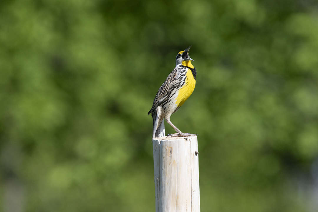
Bluebirds and Meadowlarks
https://hikes.brucetrail.org/event/bluebirds-and-meadowlarks/Sorry, the registration cut-off time for this hike has been reached.Not a member? Click here to join today!Hosting Club: Caledon Hills
Category: Nature Walks
Location (Google Maps): Meet at Bruce Trail Parking lot on 5 Sideroad Mono, east of Airport Road, at km 45.4 on the north side of the road where the trail crosses.Hike Leader(s): Gary Hall Click here to contact Hike Leader(s)
Pace: Leisurely – 3 km/hour or less
Terrain: Moderate – some hills and/or some poor footing
Distance: 3 kmDescription
This will be a car hike. From our meeting place, we’ll make a short car pool to the Bruce Trail Parking lot on the 7th Line Mono (corner of 7th Line and Airport Road) . We’ll begin by exploring the Humber Heights property and listen and watch for Bluebirds, Meadowlarks, Indigo Buntings, Field Sparrows as well as other grassland species. We’ll then retrace our steps on Humber Heights and follow the main trail through Twin Waters (a new BTC property), Mathilde’s Way and The Gosling Forest and Nature Reserve and finish at the car park on 5 Sideroad. With the exception of a 600 metre walk along the 7th Line, the hike will be entirely on BTC properties – four in all. Bring binoculars, camera, and cell phone. The Merlin App will help identify bird songs.
Urban Walk: Toronto Islands Evening Walk
https://hikes.brucetrail.org/event/urban-walk-toronto-islands-evening-walk-7/Sorry, the registration cut-off time for this hike has been reached.Not a member? Click here to join today!Hosting Club: Toronto
Location (Google Maps): Jack Layton Ferry Terminal, near the gates to Wards Island Ferry. Arrive 20 minutes prior to departure to check in with hike leader.
From Union Station take the LRT and get off at the stop Ferry Docks.Walk up to the Ferry Docks on Queens Quay West, street level. at the foot of Bay Street.
Hike Leader(s): Miriam Stevens Click here to contact Hike Leader(s)
Pace: Leisurely
Terrain: Flat
Distance: 6-9 kmDescription
After a day’s work come and “cool off” on the Toronto Islands free of fumes and traffic. Enjoy the view of the city skyline and Toronto’s beautiful island parkland.
Pack a dinner for a sit down picnic. Food is not available for purchase on the Islands early in the season. Also bring a warm jacket and flashlight.
Return fare ticket for the ferry approx $10.00 less for seniors.
Hikes will take place rain or shine.
Toronto Island evening hikes will take place every THURSDAY in MAY and JUNE 2024.
Same time and same meeting place. No preregistration is required – just show up at the ferry docks at 5:40 PM and sign with the hike leader.** As of the publication of the hike entry the start date of the Spring schedule is not available – current departure time to Wards Island is 6:00 PM, check back closer to the date to confirm the time **
- 14June 14, 2024

Car Hike: 21th Annual Excellent Orchid Adventure – Chi-Cheemaun Weekend (2 overnights)
https://hikes.brucetrail.org/event/car-hike-21th-annual-excellent-orchid-adventure-chi-cheemaun-weekend-3-overnights/Sorry, the registration cut-off time for this hike has been reached.Not a member? Click here to join today!This is a Multi-Day Hike
You are signing up for the following dates:
2024-06-14, 2024-06-15, 2024-06-16Hosting Club: Toronto, Peninsula
Category: Car Hike
Location (Google Maps): Princess Hotel
34 Bay St, Tobermory, ON N0H 2R0Hike Leader(s): Jeanette Vincent. Brenda Menezes. David Royle. Click here to contact Hike Leader(s)
Pace: Leisurely
Terrain: Hilly, Rocky, Variable
Distance: 10 – 12 KmDescription
We continue Greg Vincent’s legacy of weekends away. Please join Jeanette Vincent, Brenda and David Royle as we explore the Tip o’ the Bruce, Tobermory in search of orchids and other flowers. Our search will extend to Flowerpot Island (cost approx. $60.00 for the glass bottom ferry and Parks Canada fee). The wildflowers in the Tobermory area at this time of year are wonderful and our slow paced walks will focus on these flowers and the area’s great views. We stay and have our meals at a comfortable hotel overlooking Little Tub Harbour. Approximately 10km/day.This outing is restricted to those staying with us at the Princess Hotel in Tobermory for the weekend – the hotel fills quickly. You will need a car to access this outing. Please contact the Princess Hotel for a reservation.1-519-592-8282 or info@tobermoryprincesshotel.com and mention Vincent/Royle Excellent Orchid weekend.
Before registering at the hotel please contact Jeanette: vincentjeanette1604@gmail.com | 519-588-5916 For prices and more details.

Car Hike: Beaver Valley E2E Fundraiser Badge in 8 hikes.
https://hikes.brucetrail.org/event/beaver-valley-e2e-fundraiser/Sorry, the registration cut-off time for this hike has been reached.Not a member? Click here to join today!Hike open to BTC Members only.
This is a Multi-Day Hike
You are signing up for the following dates and times:
2024-06-14 at 08:30
2024-06-15 at 08:30
2024-06-16 at 08:30
2024-06-17 at 08:30
2024-06-21 at 08:30
2024-06-22 at 08:30
2024-06-23 at 08:30
2024-06-24 at 08:30Hosting Club: Toronto, Beaver Valley
Category: Car Hike
Location (Google Maps): Hike 1- Maple Lane, km 67.3 Blue Mountain on map 24. It is also km 0.0 of the BV. Coordinates N 44504973,W 80.331780Hike Leader(s): Smadar Junkin Click here to contact Hike Leader(s)
Pace: Brisk
Terrain: Hilly, Variable
Distance: 13.7 kmDescription
This is a fundraiser hike to keep the pledge of “ ribbon of wilderness for everyone forever “. The funds will be collected by the Toronto Bruce Trail Club and will be transferred to the Beaver Valley Club to help continuing the gear maintenance work that the team of volunteers doing.this hike will earn you the special stained glass badge of the BV.
you will be permitted to miss two of the organized hikes and make them up on your own to get the badge.
hike2- meet at km 27.9 parking- a 100 meters south of the main trail across the 10th line coordinates N 44.416209,W 80.443557 we will shuttle to 6th line. Map 25hike 3- meet at at the same place as hike 2 and shuttle to km 43.5 map 25
hike 4- meet at km 43.6 side road 7B coordinates N 44.395310,W 80.518495 we will shuttle to km 56.1 north street. Map 26
hike 5- meet at km 71.7 Johnston side road parking. Coordinates N 44.315674,W 80.549984 we will shuttle to NorthStreet.
hike 6- we will meet at the same place as hike 5 and shuttle to km 86.9 side road 13A map27hike 7- we will meet at km 86.9 side road 13A coordinates N 44.420867,W 80.562233 we will shuttle to km 99.9. Map 27
hike 8 badge day we will meet at Blantyre km 117,3 and shuttle to km 99.9. Please note that at this time the parking in Blantyre is closed. The resident across the street kindly offered us parking in an area in his property. At this time I’m not sure if the the parking will be open. More information to come at the later date.
after each hike I will be hiking a geology hike to to learn about the geology of the beaver valley and to earn the badge. If you wish to join me, let me know and I’ll send you information closer to the time of the hikes. These will not be official Bruce Trail hikes. If you are interested it might be a good idea to get Beth Gilhespy’s book “Walking Through Time” from. The conservancy office.
please bring two litres of water to each hike, bug prevalent and sun screen.
Niagara-on-the-Lake Tour
https://hikes.brucetrail.org/event/niagara-on-the-lake-tour-54/Sorry, the registration cut-off time for this hike has been reached.Not a member? Click here to join today!Hosting Club: Niagara
Category: Urban
Location (Google Maps): Meet on King St near Centre St, at the entrance to Veteran’s Memorial Park, Niagara-on-the-LakeHike Leader(s): Margaret Northfield Click here to contact Hike Leader(s)
Pace: Medium
Terrain: Easy
Distance: 6-7kmDescription
Each Friday we will explore different neighbourhoods, trails and parkland throughout Historic Niagara-on-the-Lake.Moderate pace with some weeks entirely on sidewalks and roads while others may include a mix of trails and paved pathways. Great way to build up endurance for longer more strenuous hikes.
Prepare for cooler windy conditions on open parkland and along Lake Ontario and Niagara River trails.
Plan to stay for conversation and a warm cup of coffee or tea at Sweets & Swirls, Community Centre, Niagara Stone Road, NOTL
Margaret Northfield & Robin Garrett
- 15June 15, 2024

Dufferin Hi-Lands End to End in 2 Hikes ~ Stained Glass Fundraiser Badge
https://hikes.brucetrail.org/event/dufferin-hi-lands-end-to-end-in-2-hikes-stained-glass-fundraiser-badge/Sorry, the registration cut-off time for this hike has been reached.Not a member? Click here to join today!Hike open to BTC Members only.
This is a Multi-Day Hike
You are signing up for the following dates and times:
2024-06-15 at 07:00
2024-06-16 at 07:00Hosting Club: Dufferin Hi-Land, Sydenham
Category: Fundraiser
Location (Google Maps): Jun 15: Lavender Cemetery, Mulmur Nottawasaga Townline, Creemore, ON GPS Coordinates: 44.2689881 -80.1573367. Shuttle to Parking area on 1st Line E
Jun 16: Mono Community Centre, Mono Centre Road, Mono, ON; GPS Coordinates: 44.0270957 -80.0710983. Shuttle to Parking area on 1st Line EHike Leader(s): Margaret O’Dell Click here to contact Hike Leader(s)
Pace: Brisk: 4 to 5 km/h, Fast: more than 5 km/h
Terrain: Strenuous: Hilly with steep climbs and some poor footing.
Distance: Jun 15: 27 km; Jun 16 28.5 km;Description
This series of hikes is a Fundraiser for the Dufferin Hi-Land Bruce Trail Club. All proceeds fund the activities of the Club directly. You are signing up for 2 hikes, and must be present for both to receive the beautiful Stained Glass Lady Slippers End to End badge, included in your registrationWe will hike Northbound on Jun 15 from 1st Line E to Lavender Hill for 27.0 km. We will hike Southbound on Jun 16 from 1st Line E to Mono Centre for 28.5 Km. The GPS coordinates are provided for each day’s meeting location. This hike series is intended for experienced distance hikers only; hikes will be lead at a brisk to fast pace. Be aware of your ability to join this series.
- Hikes will average 4.5 km per hour including breaks, moving pace is 5 km per hour;
- Expect to be on-trail for 6-7 hours;
- Meeting time is scheduled for an early start at 7:00am so that we’re on the trail at the earliest part of the day and avoid the heat in the afternoons;
- You must arrive no later than 15 minutes prior to the meeting time to organize shuttle; all participants are expected to participate in the shuttle;
- Any applicable parking fees will be shared within the group.
- Hikers must carry sufficient hydration, accessible snacks, small lunch, first-aid kit, rain gear, extra socks, bug spray, etc; Check the weather as you pack your gear;
- If you have any questions or concerns, please use the Contact the Hike Leader above.
Bus Hike: Pretty River
https://hikes.brucetrail.org/event/bus-hike-pretty-river-2/Sorry, the registration cut-off time for this hike has been reached.Not a member? Click here to join today!Trip Information
Departure Time: 08:00
Return to City Time: 18:15
Departure Point: York Mills Bus PickupOptional Items
Hosting Club: Toronto, Blue Mountains
Category: Bus Hike
Location (Google Maps): Pretty River Valley Provincial ParkHike Leader(s): Martina Furrer, Roland Mark, Michael Humpage and Ross Estrella Click here to contact Hike Leader(s)
Pace: Fast, Moderate
Terrain: Hilly
Distance: Fast (16 to 18 km), moderate (13 km)Description
Join us for a fun and challenging hike through Nottawasaga Lookout Provincial Nature Reserve and Pretty River Valley Provincial Park. Our efforts will be rewarded with great views and hopefully the forest floor will be dotted with wildflowers. From Osler Bluff and the Petun Side Trail we should have amazing views of Georgian Bay.We will split into two groups. The moderate group will do about 13 km at a pace of approximately 3 km/hr. The fast group will hike 16 to 18 km at a 4 km/hr pace (including on hills).
Pack lunch, water (about 2 litres), sun protection, rain protection, and bug protection.
Refreshment stop after if time allows.
Bus departs 10 York Mills Rd at 8 AM.
Car Hike: Hike of 2 lakes
https://hikes.brucetrail.org/event/car-hike-hike-of-2-lakes/Sorry, the registration cut-off time for this hike has been reached.Not a member? Click here to join today!Hosting Club: Toronto
Category: Car Hike
Location (Google Maps): Park along Fairfield Dr. or Dufferin Street. Gather at trail head on Dufferin Street.Hike Leader(s): Mohammad Aghamiri
Pace: Moderate
Terrain: Variable
Distance: 14-17 kmDescription
We will hike in trails around Seneca lake and Mary Lake, pass by Eaton hall and visit Pine farm where you can enjoy coffee, tea, apple pie during our snack time.Some safety procedures during the hike:
1-Hikers must stay between the leader and the sweep.
2-Hikers must advise the leader or the sweep if they wish to leave the group.
3- Hikers must follow the whistle instructions: 1 blast- stay where you are; 2 blasts come to the leader; 3 blasts – come to the leader quickly.
4-Hike leader may request volunteers to stop at trail intersections, they need to help hikers to the direction the group walk and wait till they see the sweep .
5-Hikers have to make sure they can see the persons behind and in front of them.
Beaver Valley Geology Hikes Badge Hike #1/8
https://hikes.brucetrail.org/event/beaver-valley-geology-hikes-badge-hike-1-8/Sorry, the registration cut-off time for this hike has been reached.Not a member? Click here to join today!This is a Multi-Day Hike
You are signing up for the following dates and times:
2024-06-15 at 09:00
2024-07-24 at 09:00
2024-08-14 at 09:00
2024-09-07 at 09:00
2024-09-18 at 09:00
2024-09-25 at 09:00
2024-10-02 at 09:00
2024-10-12 at 09:00Hosting Club: Blue Mountains
Category: Register online ONLY
Location (Google Maps): Hike meets in the parking lot behind Tim Hortons on First St. in Collingwood.Hike Leader(s): Annette Sandberg Click here to contact Hike Leader(s)
Pace: Medium – 3 to 4 km/hr
Terrain: Moderate – Some hills and/or some poor footing
Distance: 7.1 kmDescription
This badge is earned by hiking each of 8 hikes outlined in Beth Gilhespy’s first Bruce Trail Geology book, Walking Through Time, and then submitting a log which includes the required photo taken during each of the hikes. You can do the hikes with us, on your own, or a combination of both. This is a great opportunity to boost your knowledge of the geology of the Niagara Escarpment. Gather some hiking buddies and become rock hounds! Description: Len Gertier Memorial Loree Forest: Natural Arch at Stop 4 (page 43). Natural arches are created when water pounding against a cliff face exploits crack and crevices, gradually wearing the rock away. Natural arches can become flowerpots if erosion continues. Thousands of years ago, the level of the Great Lakes was significantly higher and lapped up against the promontory of Loree Forest.Easy Does it Hike
https://hikes.brucetrail.org/event/easy-does-it-hike-2/Sorry, the registration cut-off time for this hike has been reached.Not a member? Click here to join today!Hosting Club: Niagara
Category: In and Out
Location (Google Maps): Easy Does it Hike, Park at McGarr Realty, 5 St. Paul St., St Catharines. We’ll walk in the area on city streets and local paths.Hike Leader(s): Diane Marlatt Click here to contact Hike Leader(s)
Pace: Leisurely
Terrain: Easy
Distance: 3kmDescription

Just For Fun - Hike Through Six BTC Protected Natural Areas
https://hikes.brucetrail.org/event/just-for-fun-hike-through-six-btc-protected-natural-areas/Sorry, the registration cut-off time for this hike has been reached.Not a member? Click here to join today!Hosting Club: Caledon Hills
Category: General
Location (Google Maps): Meet at the Bruce Trail Parking Lot on Mono 5 Sideroad on the north side of the road where the Trail crosses. Google GPS Coordinates: 43.974055, -79.984988Directions: From Airport Road turn east onto 5 Sideroad and drive for 600 metres. The parking lot is on the left hand side.
Hike Leader(s): Sandy Green and Dylan “Lana” Hubbard Click here to contact Hike Leader(s)
Pace: Medium – 3 to 4 km/hour
Terrain: Moderate – some hills and/or some poor footing
Distance: 10 kilometresDescription
Hike through six Bruce Trail Conservancy protected natural areas in the south eastern area of Hockley Valley. Bring your choice of hydration and snacks. Sturdy footwear is highly recommended. This hike can be counted towards your 60 for the 60th Connecting People With Nature badge.
9:30 Queenston Heights Loop "NOTE NEW THEME AND ROUTE"
https://hikes.brucetrail.org/event/930-roses-roses-roses-at-niagara-parks-botanical-gardens/Sorry, the registration cut-off time for this hike has been reached.Not a member? Click here to join today!Hosting Club: Niagara
Category: Loop
Location (Google Maps):Locust Grove Picnic Area
Hike Leader(s): Karen Couch Click here to contact Hike Leader(s)
Pace: Medium
Terrain: Moderate
Distance: 6-8 kmDescription
Hike the main trail and side trails, in and around Queenstown Heights while we enjoy the flowers that Niagara Parks has on display.Much of this hike is in the open, so participants are reminded to come prepared for the sun and heat (e.g., sunscreen, hat and water).
Chi-Cheemaun Festival Hike in Tobermory
https://hikes.brucetrail.org/event/chi-cheemaun-festival-hike-in-tobermory/Sorry, the registration cut-off time for this hike has been reached.Not a member? Click here to join today!Hosting Club: Peninsula
Location (Google Maps): Meet at Little Tub Harbour at the Peninsula Bruce Trail Club Tent in Tobermory
Hike Leader(s): Darci Lombard Click here to contact Hike Leader(s)
Pace: Medium
Terrain: Easy, Moderate
Distance: ~ 5 KM for entire hike. Or, ~2 KM for the shorter hike.Description
Join local PBTC hike leaders for a guided hike of the nearby Bruce Trail – both main trail and the Burnt Loop Sidetrail. Immerse yourself in the beauty of the cedar forest, as you witness the pretty waterviews of Little Dunks Bay and pretty vistas of Georgian Bay, Flower Pot Island, Bears Rump Island, and Middle Island. You will also pass the Bruce Peninsula National Park Visitor Centre – a must-see – if you are visiting Tobermory for the first time! And, don’t forget the iconic northern Bruce Trail Cairn – where the official opening of the Bruce Trail occurred in 1967. The main trail is wheelchair accessible to the first lookout on the Burnt Loop Access Trail. This hike is suitable for families with children 8 years and older. Here, you may choose to retrace your steps to the village on your own. Or, consider continuing with the hike leaders on the rest of Burnt Loop Sidetrail . If joining the hike for the entire Burnt Loop Sidetrail , be prepared for rocky and rooty terrain which requires good balance. Wear sturdy footwear and sun protective clothing. Bring a backpack to carry your waterbottle and a light snack. If hiking the full hiking route, be prepared for about a 3 hour hike. If hiking to the first lookout and back, this will take approximately 1 hour.
iNaturalist Summer Solstice Hike #2
https://hikes.brucetrail.org/event/inaturalist-summer-solstice-hike-2/Sorry, the registration cut-off time for this hike has been reached.Not a member? Click here to join today!Hosting Club: Dufferin Hi-Land
Category: Special Events
Location (Google Maps): Meet at Prince of Wales and 15 Sideroad. Registration is not requiredHike Leader(s): Tom Thayer Click here to contact Hike Leader(s)
Pace: Leisurely
Terrain: Easy, Moderate
Distance: 6 kmsDescription
Registration is not required for this event. Please feel free to join us with or without registering.Join us for a hike through Pine River Nature Reserve and learn how to use the iNaturalist App to help the Bruce Trail protect endangered/at-risk species, monitor existing species, identify invasive species that need to be removed, and learn about the plans to enhance and enrich biodiversity.
Interact with the Bruce Trail Conservancy’s Conservation and Ecology specialists, meet some of our new trail ambassadors, and learn more about how the Dufferin Hi-Land Bruce Trail Club is working with the BTC to provide a sustainable and healthy future for generations to come.
Please Note: You will need a mobile device with the iNaturalist App installed and updated in order to take part in this event. You can download the app from the App Store or Google Play Store. More information about the iNaturalist program is available here: https://brucetrail.org/what-we-do/#iNaturalist
Everyone is welcome, member and non-member alike.
Toronto Urban Badge Hike - 7 of 7
https://hikes.brucetrail.org/event/toronto-urban-badge-hike-7-of-7-4/Sorry, the registration cut-off time for this hike has been reached.Not a member? Click here to join today!Hosting Club: Toronto
Location (Google Maps):
Toronto
Hike Leader(s): Brian Rideout Click here to contact Hike Leader(s)
Pace: Moderate
Terrain: Flat
Distance: 9 kmDescription
Please join me at the south east corner of Overlea Blvd and Don Mills Rd by 10 AM. We will hike south on the Don Trail to the Distillery District (km 62.4 to km 71.4). Here is an online map with km markings of our route for all 7 hikes for the Toronto Urban Badge.Please make sure you bring at least 2 liters of water, a lunch, bug spray and sunscreen.
Summer Solstice Hike # 1 - Forest Bathing
https://hikes.brucetrail.org/event/summer-solstice-hike-1-forest-bathing/Sorry, the registration cut-off time for this hike has been reached.Not a member? Click here to join today!Hosting Club: Caledon Hills, Dufferin Hi-Land
Category: Nature Walks
Location (Google Maps): BTC Reference Guide, Ed. 31 – Map 20; departing from the parking area at the dead end of 2nd Line E, (west of main trail km 24.3)
Directions: If arriving from the south, take Prince of Wales Rd. north from Primrose 3+ km to 5 Sideroad. Right (east) on 5 Sideroad to 1st Line. Left (north) on 1st Line E. Right (east) on 8 Sideroad. Left (north) on 2nd Line E to dead end where there is ample parking.Hike Leader(s): Janice McClelland Click here to contact Hike Leader(s)
Pace: Leisurely – 3 km/hour or less
Terrain: Moderate – some hills and/or some poor footing
Distance: 6.8 kmDescription
This is a walk that “fills my heart with joy”. We follow the Oliver Creek west as it tumbles along. Then the views of the Escarpment as the main trail rises. Lunch at a restful nook along Oliver Creek. After lunch, we walk the main trail and the Enchanted Forest Side Trail, observing the forest. Return via the Moss Haven Side Trail with its sensitive natural areas, main trail and Oliver Creek Side Trail. Note: we will observe silence during our walk with plenty of time for conversation before and after the walk and during our lunch break. – after just 10 minutes quietly absorbing nature, the body responds positively. Please bring water and lunch.
Nature Seekers - Exploring the Hockleycrest Area
https://hikes.brucetrail.org/event/nature-seekers-exploring-the-hockleycrest-area-2/Sorry, the registration cut-off time for this hike has been reached.Not a member? Click here to join today!Hosting Club: Caledon Hills
Category: Introductory
Location (Google Maps): Meet at the Bruce Trail Parking Lot on Mono 5 Sideroad on the north side of the road where the Trail crosses. Google GPS Coordinates: 43.974055, -79.984988Directions: From Airport Road turn east onto 5 Sideroad and drive for 600 metres. The parking lot is on the left hand side.
Hike Leader(s): Sandy Green and Dylan “Lana” Hubbard Click here to contact Hike Leader(s)
Pace: Leisurely – 3 km/hour or less
Terrain: Moderate – some hills and/or some poor footing
Distance: 5.5 kilometresDescription
Loop through the Hockleycrest area on main and side trails. Bring your choice of hydration and snacks. Sturdy footwear is highly recommended. This hike can be counted towards your 60 for the 60th Connecting People With Nature badge.Summer Solstice Hike #5 - GeoHike
https://hikes.brucetrail.org/event/summer-solstice-hike-5-geohike/Sorry, the registration cut-off time for this hike has been reached.Not a member? Click here to join today!Hosting Club: Dufferin Hi-Land
Category: General Hike
Location (Google Maps): Meet at the Whitetail Refuge parking (NW corner). Arrangements have been made to park at the new refuge for this day only due to limited parking elsewhere. Parking is on Mono Centre Road 800 m south of the intersection with Country Rd. 8. The street address is 754416 Mono Centre Rd. (which may not be accurate).
Please arrive 15 minutes early to register and sign waivers if necessary.Hike Leader(s): Lynda Bloom Click here to contact Hike Leader(s)
Pace: Leisurely
Terrain: Moderate
Distance: 8 kmDescription
Registration is required. Please complete waivers online if possible.We will walk up 2nd Line EHS into Mono Cliffs Park.
Why are there cliffs in the park? Are there any fossils? This leisurely hike will make many stops to look at rocks and talk about the geological history of the area. Don’t forget to bring your camera.
We will use several side trails, mostly the Walter Tovell and South Outlier Trails, to visit the north and south Outlier exposures.
Please wear sturdy footwear as there are hills and stairs. Pack water, snacks and dress for the weather.
Suitable for children over 10 years old.
Boyd’s Crevices
https://hikes.brucetrail.org/event/boyds-crevices-6/Sorry, the registration cut-off time for this hike has been reached.Not a member? Click here to join today!Hosting Club: Sydenham
Category: General Hike
Location (Google Maps): 11th Concession – north of 83.9 km where the road intersects the Owen Sound Rail Trail (Map # 32).Hike Leader(s): Ian Mills Click here to contact Hike Leader(s)
Pace: Leisurely: 3 km/h or less
Terrain: Moderate: Some hills and/or poor footing, There might be muddy sections., There might be sections with water on the trail.
Distance: 5+kmDescription
In and out hike to the giant dolostone blocks where we will have a quick break for snacks. Proper hiking footwear required and a walking stick could be helpful. BTC Map # 32.
iNaturalist Summer Solstice Hike #3
https://hikes.brucetrail.org/event/inaturalist-summer-solstice-hike-3/Sorry, the registration cut-off time for this hike has been reached.Not a member? Click here to join today!Hosting Club: Dufferin Hi-Land
Category: Special Events
Location (Google Maps): Meet at Prince of Wales and 15 Sideroad Registration is not requiredHike Leader(s): Tom Thayer Click here to contact Hike Leader(s)
Pace: Leisurely
Terrain: Easy, Moderate
Distance: 6 kmsDescription
Registration is not required for this event. Please feel free to join us with or without registering.Join us for a hike through Pine River Nature Reserve and learn how to use the iNaturalist App to help the Bruce Trail protect endangered/at-risk species, monitor existing species, identify invasive species that need to be removed, and learn about the plans to enhance and enrich biodiversity.
Interact with the Bruce Trail Conservancy’s Conservation and Ecology specialists, meet some of our new trail ambassadors, and learn more about how the Dufferin Hi-Land Bruce Trail Club is working with the BTC to provide a sustainable and healthy future for generations to come.
Please Note: You will need a mobile device with the iNaturalist App installed and updated in order to take part in this event. You can download the app from the App Store or Google Play Store. More information about the iNaturalist program is available here: https://brucetrail.org/what-we-do/#iNaturalist
Everyone is welcome, member and non-member alike.