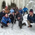
Description Join us for an awesome weekend of cross-country skiing, snowshoeing and winter hiking in beautiful Gatineau Park. Explore over 200 km of ski trails (classic and skate), 80 km of snowshoe trails, and 11 km of winter walking trails. Enjoy two full days and two half days in the park. Guided snowshoe hikes (two levels) each day.
Transportation: We will travel in a luxury highway coach equipped with a washroom. Coach fare is $170 for adults and children over 12, $100 for children 12 and under. Bus will depart at 7 AM on Friday March 1 from 10 York Mills Rd. We plan to be back in Toronto between 8 and 9 PM on Monday March 4.
Accommodation: We will be staying at the Best Western Plus Gatineau-Ottawa Downtown on the Ottawa River. It’s walking distance to downtown Ottawa (shops, restaurants, and the Rideau Canal Skateway) and a 15-minute drive from the Gatineau Park Visitor Centre in Old Chelsea. Accommodation cost is $496.26 per room or $248.13 per person based on double occupancy, in standard hotel rooms with two double beds. Single occupancy costs the same: $496.26 per room. These rates include three nights’ accommodation and three hot breakfasts. Prices include all taxes and fees. Gratuity is extra.
Extra costs: Lunches, dinners, and trail passes are not included in the above prices. All participants will need to pack lunch for Friday. We will have a group dinner at the Best Western Plus Gatineau-Ottawa Downtown on Friday. Saturday and Sunday evenings pick from any of the many restaurants in downtown Ottawa or downtown Gatineau. Trail fees are: $22 for adult skiers, $17 for youth and senior skiers (13 to 17, and 60+), $12 for adult snowshoers, and $9 for youth and senior snowshoers (13 to 17, and 60+). Access to all trails is free for children 12 and under. You may be asked to purchase your trail passes online or on site yourself.
Cancellation policy: The trip will not be cancelled due to weather. We are hoping for lots of snow and winter temperatures. If there isn’t enough snow to ski and/or snowshoe, we will hike. Coach fares are non-refundable.
Registration instructions:
Reserve and pay for your seat on the coach via this webpage starting at 8pm on Sunday October 22, 2023. Ensure you and your roommate book your seats at the same time. Enter your roommate’s name in theAdditional Information field on the registration form.
You or your roommate must then call the Best Western Plus Gatineau-Ottawa Downtown (1-800-265-8550) or go to https://www.bestwestern.com/en_US/book/hotel-rooms.67015.html?groupId=M21NI9V4 to reserve your room. If you are booking a room for two people online, click on the Edit button (top right), then set the number of adults to 2, then click on the Update button, then scroll down and click on the Submitbutton. On the next screen, enter the required information, including your credit card details, then click on the Make Reservation button. If you book your room by phone then let the hotel staff know you are with the Toronto Bruce Trail Club; this will ensure you get the group discount. The hotel will only accept one reservation per room.
Thirty-five rooms have been reserved for our group. Please book your seat on the coach and your hotel room at the same time. If you wish to share a room but do not have a roommate, please do not book your seat until you have found a roommate. If you need help finding a roommate, contact Martina.
Description Each Friday we will explore different neighbourhoods, trails and parkland throughout Historic Niagara-on-the-Lake.
Moderate pace with some weeks entirely on sidewalks and roads while others may include a mix of trails and paved pathways. Great way to build up endurance for longer more strenuous hikes.
Prepare for cooler windy conditions on open parkland and along Lake Ontario and Niagara River trails.
Plan to stay for conversation and a warm cup of coffee or tea at Sweets & Swirls, Community Centre, Niagara Stone Road, NOTL
Hosting Club: Iroquoia, Caledon Hills Category: General Hike Location (Google Maps): Location 4th line ehs, by peter beecham side trail n43.976327-w80.026621 Park alongside the road Arrive for 08:15 so we can depart at 08:30 no fee Edition 31 map 19
Pace: Brisk – 4 to 5 km/hr Terrain: Slippery and Steep Sections Distance: Roughly 20k each of the 4 days ( 71.3 total )
Description Description
Come out and hike the Caledon Hills over the first four Saturdays of March. ( Mar-02,09,16,23) Once you complete all 4 hikes, you will qualify for 2 badges; Caledon Hills NEW E2E Badge and for the 60th Anniversary Badge. The cost of each badge is $10.00 for BTC members, $15.00 for non BT members . By completing the four hikes before Mar-21, and putting in a minimum of 7.5 hours, we also have the winter badge option. Please dress according to the weather presented that day. Bring enough food and water (electrolytes) for a long day of hiking. This is a car shuttle hike. Please have your vehicle ready as everyone will be taking a turn either to drive us all to the start point of our hike or to get our drivers back at the end of the day. I will send out a schedule a week prior to the first hiking day to all registered participants. The first day will be at the Mono Community Center and we will be walking south.
You may sign up for any number of the 4 hikes but if you complete all 4 hikes you will qualify for the badges at $10 each.
Conditions may be difficult due to spring weather. Please ensure you are physically able to hike at a brisk pace (4-5km/hr) for a minimum of 5hrs.
Please arrive 15 min ahead of time.
COVID-19 Precautions Before, During and After your Hike
Each hiker joining a Bruce Trail Club organized hike must perform a self-screening check before hiking. Find Ontario’s self-assessment tool here: https://covid-19.ontario.ca/self-assessment/ If you are experiencing COVID-19 symptoms, stay home. Transportation
It is the Bruce Trail Conservancy’s current policy that car shuttles are allowed. It is at the discrepancy of individual hike leaders to make that decision.
Other Guidelines
Arrive 15 minutes before the start of the hike. Wear sturdy footwear and appropriate attire for the weather and the terrain. Hiking poles are a good idea in any season, especially if the terrain is rocky or slippery. We will require icers/crampons for this hike. Wearing appropriate clothing and footwear for the weather. Always carry I.D. and your health card. Bring sufficient water and snacks (and or lunch). A minimum of 1.5L of water is recommended. Bring sunscreen Bring your own first aid kit. Please leave dogs at home.
Hosting Club: Blue Mountains Category: Register in person the morning of hike. Location (Google Maps): Hike meets in the parking lot behind Tim Hortons on First St. in Collingwood.
Pace: Medium – 3 to 4 km/hr Terrain: Moderate – Some hills and/or some poor footing Distance: 8 km
Description We will park on Sideroad 7B at km 43.5 in the Beaver Valley section. The in/out hike proceeds north on the white blazed trail which winds along the top of the escarpment before descending through a crack to the bottom. We then climb to the top again before descending once more to km 39.3. We get to enjoy it all over again as we retrace our steps back to the cars. Bring a snack or lunch and water.
Hosting Club: Dufferin Hi-Land Category: General Hike Location (Google Maps): Parking lot behind Kilbride Public School in Kilbride. North end of Panton Street. Northwestern end of the Kilbride Side Trail near km 96.8 BTC map 10.
Pace: Medium Terrain: Moderate, Slippery and Steep Sections, Slippery Sections Likely Distance: 17 kms
Description Join us on the sixth of seven shuttle hikes to complete the Iroquoia Section. We will climb Mount Nemo, cross the Bronte Creek valley, learn why Bronte Creek is called Bronte Creek, learn about an explosion that could be heard for miles around, then head into Halton gem, Kilbride. Some road walking. Hiking boots, icers and poles essential. Please dress in layers for the weather. Mitts a good idea. Please bring a smile, warm drink, water, a snack and a lunch. Please meet at 8:45 am to be ready to shuttle at 9 am. Please bring a garbage bag and footwear to change into for the shuttle after the hike (it might be muddy).
Hosting Club: Caledon Hills Category: General Location (Google Maps): Meet north of the intersection of Cataract Road and Mississauga Road at the Elora Cataract Trailway Trail Head. Google Coordinates: 43.813120, -80.028656
Directions: From ON-10 head west on Charleston Sideroad/Peel Regional Rd. 24 for 5.5 km. Turn left onto Mississauga Rd. and drive for 1.0 km. Park on west shoulder.
Pace: Medium – 3 to 4 km/hour Terrain: Strenuous – hilly with steep climbs and some poor footing Distance: 12 kilometres
Description
Register individually for one, a few, or all of the Frosty 5 and 60 for the 60th Anniversary Badge Combo hikes. Participants who complete five hikes will be eligible to receive a CHBTC Winter badge and a 60th Anniversary badge. This hike explores trails within the Forks of the Credit Provincial Park. Bring your choice of hydration and snacks. Hiking boots and icers/crampons are required. Hikes in the series take place on select Wednesdays and Sundays. (Note: If you wish to purchase badges, the cost of each badge is $10.00 for BTC members and $15.00 for non-members.)
Hosting Club: Iroquoia Category: General Hike Location (Google Maps): Roadside on Winston Churchill Blvd, just north of Terra Cotta Conservation Area. Meet at 9:15 am
Pace: Medium – 3 to 4 km/hr Terrain: Dependent on Conditions, Moderate – Some hills and/or some poor footing Distance: 8.5 kms
Description Hiking along the main trail, across Heritage Rd and around to the Rockside Side Trail and back on the main trail to the cars. This trail has some easy parts and some challenging rocky parts, so come prepared. There’s a bit of road walking. Please bring icers. Hike is dependent upon weather conditions. If there’s enough snow, we could snowshoe. Bring water and a snack, as needed. I’ll send an email two days before the hike to confirm.
Please join me at Kennedy Station by 10:15 am. We will take the 12 Kingston Rd bus departing 10:30 am, arriving 10:45 am.
We will hike along Kingston Rd, down to and east olong the Lake on the Doris MacCarthy Trail to Guildwood and then to Beechgrove Dr. The estimated distance is 11.4 km. Here is an online map of our route – Brimley to Beechgrove
Bring a snack, at least 2 liters of water, and icers. Dress for cold weather.
Meet at Centennial Park on Church St in Fenwick. Park in first parking lot. After the hike we can go to the Grill on Canboro for refreshments. This is a flat walk, minimal if any mud. Bring water and dress for the weather.
Description This will be an in/out hike. We’ll walk for an hour and then turn around. The terrain is flat (this was an old railway line) and in most sections will be dry. If you have any medical condition that you think I should know about, please see me the morning of the hike.
Hosting Club: Sydenham Category: General Hike Location (Google Maps): Meet in the parking lot behind the Grey-Sauble Conservation Authority head office. 237897 Inglis Falls Road, Owen Sound
Pace: Medium: 3 to 4 km/h Terrain: Strenuous: Hilly with steep climbs and some poor footing., There might be icy and slippery sections. Distance: 5.2 km
Description We will hike a loop from the GSCA parking lot along the blue and white trail to Inglis Falls, enjoy the sights, and cross the road into Smith Bush. There we will follow the white trail again to Grey Rd 5 and finish the loop on the blue Creamery Hill Side trail back to the cars. The climb up to the falls has a steep section, icers might be needed, or snow shoes, depending on the weather and conditions. Poles are advised. Map 32. If you have questions, contact the hike leader at 519 379 2573.
Pace: Medium Terrain: Strenuous Distance: +/- 10kms
Description To avoid the muddy conditions, we will be meeting at Rockway Parking lot instead of Short Hills. We’ll hike out for 75 minutes then back to the parking lot. Bring water, poles, and icers if slippery. Please check the weather and dress appropriately.
Description Hike the main and side trails of Short Hills Provincial Park. Bring hiking boots, icers, and water. This hike qualifies for the Winter hiking badge. See website for details. https://niagarabrucetrail.club/badges/
Hosting Club: Caledon Hills Category: Tuesday Hikers Location (Google Maps): Pear Tree parking lot, 15 Sideroad. Driving directions: From Highway 401 going west, turn right (north) on Road 25, left on 15 Sideroad, drive about 300 m to Pear Tree parking lot on the left.
Hike Leader(s): Mohammad Shafiq
Pace: Medium – 3 to 4 km/hour Terrain: Moderate – some hills and/or some poor footing Distance: 12 km
Description Will hike southwards from the parking lot, main Bruce Trail, Al Shaw Side Trail and parts of Hilton Falls Side Trail, there and back. Dress according to weather, poles are recommended, keep icers in the bagpack. Bring water and snack. Hike leaders phone contact for hiking day: 416-566-0503
Hosting Club: Dufferin Hi-Land Category: Tuesday Hike Location (Google Maps): Caledon Hills, Map 17 Meet at parking on Innis Lake Rd, just north of Finnerty Sideroad (31.7)
Pace: Medium Terrain: Dependent on Conditions, Moderate, Slippery and Steep Sections Distance: 8 km, short hike 3km
Description
We will hike north to the end of Innis Lake Rd, where we enter the Dingle. After 3 km we will hike a short portion of the Oak Ridges Moraine Trail to a lookout, then return along the main trail. The shorter hike will turn back as we enter the Dingle. Please come prepared for the weather and bring a snack.
Hosting Club: Niagara Category: Car Pool Location (Google Maps): Meet at Merritt Island Parking Lot Welland. Car Pool to the Smoking Buddha, 265 King Street Port Colborne.
Hosting Club: Caledon Hills Category: General Location (Google Maps): Meet north of the intersection of Cataract Road and Mississauga Road at the Elora Cataract Trailway Trail Head. Google Coordinates: 43.813120, -80.028656
Directions: From ON-10 head west on Charleston Sideroad/Peel Regional Rd. 24 for 5.5 km. Turn left onto Mississauga Rd. and drive for 1.0 km. Park on west shoulder.
Pace: Medium – 3 to 4 km/hour Terrain: Strenuous – hilly with steep climbs and some poor footing Distance: 12 kilometres
Description
Register individually for one, a few, or all of the Frosty 5 & 60 for the 60th Anniversary Badge Combo hikes. Participants who complete five hikes will be eligible to receive a CHBTC Winter badge and a 60th Anniversary badge. This hike explores trails within the Forks of the Credit Provincial Park. Bring your choice of hydration and snacks. Hiking boots and icers/crampons are required. Hikes in the series take place on select Wednesdays and Sundays. (Note: If you wish to purchase badges, the cost of each badge is $10.00 for BTC members and $15.00 for non-members.)
Pace: Medium – 3 to 4 km/hr Terrain: Moderate – Some hills and/or some poor footing Distance: 5 km
Description The 5km loop snowshoe provides an interesting blend of the scenic and the historic along the river and surrounding woods. There are some steep, but short ascents. The second half of the 19th century saw the area develop into a thriving community, built around the water power of Walter Creek. At the halfway point, we will take in the view of the falls and valley from the observation platform, and then after completing the loop, there will be the option to have lunch at the Inn. Bring a snack or lunch and water. Note: This could be a snowshoe hike or “icers”, depending on the snow conditions.
Pace: Medium Terrain: Moderate, Some steep sections Length of Hike: Approx. 5 km
Description This is an in and out hike through hardwood forest, lovely in the winter. On winter hikes we may encounter bare ground, light snow, deep snow, or ice. Please bring snowshoes and icers to our Winter Wednesday Walkers outings. Wear appropriate clothing for the weather plus water and a snack.
COVID-19 Precautions Before, During and After your Hike
Each hiker joining a Bruce Trail Club organized hike must perform a self-screening check before hiking. Find Ontario’s self-assessment tool here: https://covid-19.ontario.ca/self-assessment/
If you are experiencing COVID-19 symptoms, stay home.
Other Guidelines
Arrive 15 minutes before the start of the hike.
Wear sturdy footwear and appropriate attire for the weather and the terrain. Hiking poles are a good idea in any season, especially if the terrain is rocky or slippery. In winter, snowshoes or icers/crampons are needed when conditions dictate. Wearing appropriate clothing and footwear prevents injuries and shows consideration for a safe and positive group hiking experience.
Always carry I.D. and your health card.
Bring sufficient water and snacks (or lunch if indicated). A minimum of 1L of water is recommended on all hikes, and 3L is recommended for long, challenging hikes in the heat of the summer.
Bring sunscreen and insect repellent (for spring and summer hikes).
Hosting Club: Sydenham Category: An evening walk. Location (Google Maps): Meet in the municipal parking lot by the river on the west side of 1st Ave. E between 7th St. E and 8th St. E in Owen Sound.
Pace: Brisk: 4 to 5 km/h Terrain: Moderate: Some hills and/or poor footing, There might be icy and slippery sections. Distance: Approx 5 km
Description Join us for a brisk evening hike exploring Owen Sound trails and neighbourhoods. Please bring icers in case of icy conditions. You are invited to join us for refreshments following the hike. There is no need to show up 15 minutes early for this hike, but the hike will start promptly at 7:00 pm. For further information please click on the “Contact the Hike Leader” link.
Description From Jordan Hollow Hike the main trail to Upper and Lower Balls Falls, Moyer Road or Louth and Return. You must register for each hike. Bring Poles, sunscreen, bug spray, snack and a drink and dress for the weather
Description Hike the main and side trail around Jordan and Ball’s Falls. Bring hiking boots, water and icers. This hike qualifies for the Winter hiking badge. See website for details. https://niagarabrucetrail.club/badges/
Hosting Club: Iroquoia Category: General Hike Location (Google Maps): Meet at the corner of 10 Side Road and 4th Line, off Guelph Line, north of Campbellville.
Pace: Medium – 3 to 4 km/hr Terrain: Dependent on Conditions, Moderate – Some hills and/or some poor footing Distance: 8 kms
Description We will hike several of the bike trails (including two new trails that were recently created) in a large loop. Depending on the amount of snow, this could also be a snowshoe hike. I will email you two days prior to confirm. Please bring icers anyway. Hike is dependent on weather conditions.
Description Each Friday we will explore different neighbourhoods, trails and parkland throughout Historic Niagara-on-the-Lake.
Moderate pace with some weeks entirely on sidewalks and roads while others may include a mix of trails and paved pathways. Great way to build up endurance for longer more strenuous hikes.
Prepare for cooler windy conditions on open parkland and along Lake Ontario and Niagara River trails.
Plan to stay for conversation and a warm cup of coffee or tea at Sweets & Swirls, Community Centre, Niagara Stone Road, NOTL
Description Let’s launch the Spring & Migration Monitor Hikes with an easy, low-impact, out and back stroll along the Cape Chin Drive Way to the Cape Chin Point. This will be a weather dependent hike. We will take a break at Cape Chin to observe the changing shoreline that stretches to the South. Will the Sandhills have returned to the Cape Chin wetlands? Bring you binoculars and keen sense of observation. Open to everyone!
Pace: Leisurely: 3 km/h or less Terrain: Easy: Mostly flat and good footing., Moderate: Some hills and/or poor footing, There might be icy and slippery sections. Distance: 5-6 km
Description We will snowshoe a western loop around Kemble Wetlands and part of Kemble Rock Reserve, but avoid the upper escarpment sections . Snowshoes/icers depending on the conditions, poles, water and snack suggested. Several options and final route can be decided at trail head. If you are unable to register, please call or text the leader at 226-787-8804.
Pace: Brisk – 4 to 5 km/hr Terrain: Strenuous – Hilly with steep climbs and some poor footing Distance: 6 km
Description CONTACT Hike Leader to get directions for meet-up point. We will park at the side of the road at the Noisy River Provincial Park on County Road 9. We will descend into the park crossing the Noisy River before ascending to Concession 9. At this point, we will turn around and hike back to County Road 9. This 2km stretch will be repeated two more times for a total of 6kms. A very hilly hike. Bring lots of water, snacks and lunch. Purchase your Winter R2R badge online if all three hikes were completed ($10.00).
Description Cancelled because spring appears to be here to stay.
No trail fees at Arrowhead! Bus cost includes park admission.
Bus departs 10 York Mills Rd at 8:00 AM and Major Mackenzie Dr and HWY 400 Park and Ride at 8:20 AM. If you wish to be picked up at the Major Mackenzie Dr and HWY 400 Park and Ride, select that option when you register. Please arrive 15 minutes before departure. The bus waits for no one.
Join us for an awesome day of winter fun at Arrowhead Provincial Park. For information about trail conditions visit: https://www.ontarioparks.com/skireport. For information about the park visit: https://www.ontarioparks.com/park/arrowhead. Join Frank and Jen for a guided snowshoe hike, or enjoy self-guided skiing on trails groomed for classic and skate skiing. After skiing or snowshoeing spend some time ice skating (if open) in the forest.
There are no food services in the park. Pack water/tea and lunch.
Ski and snowshoe rentals available.
Coach fares and park admission must be paid online when you register. Masks are recommended while on the bus.
Description Explore the trails that wind through the beautiful valley at Boyd Conservation Area and the William Grainger Greenway. We will have lunch/snack in shelter with seated area,
It is winter time all participants are required to have Ice cleats with them, have proper shoes, warm clothing and hot drinks with you.
Please carefully read safety procedures during the hike:
1-Hikers must stay between the leader and the sweep.
2-Hikers must advise the leader or the sweep if they wish to leave the group.
3- Hikers must follow the whistle instructions: 1 blast- stay where you are; 2 blasts come to the leader; 3 blasts – come to the leader quickly.
4-Hike leader may request volunteers to stop at trail intersections, they need to help hikers to the direction the group walk and wait till they see the sweep .
5-Hikers have to make sure they can see the persons behind and in front of them.
Description This challenging “hike” is intended for those wishing to train for future challenging hikes. Choose your own pace to go up and down the moderately steep hill for 90 minutes with a brief flat walk partway through. The terrain is a hard packed gravel surface. Bring water, hiking poles, snack and dress for the weather.
Pace: Brisk, Medium Terrain: Dependent on Conditions, Moderate, Slippery and Steep Sections Distance: 19 km
Description This the first of five “small group” hikes from March through to June, progressively increasing in both length and total ascent. We’ll start with a 19 km/ 450meter ascent hike, progressing to 25 km with up to approximately 1000 meters of total ascent over the 4 month period. By its nature, this hike will suit experienced hikers who want to up their game. This first hike will be a loop hike within the Dundas Valley Conservation area. Normally, icers are required this time of year. Have them available just in case.
Description This hike is part of a series of urban hikes exploring graffiti art, culture, and social history in Toronto’s streets, laneways, underpasses, and parks across the city. These hikes provide opportunities for reflection on our own identity, personal history, examining our connection to each other and to the land, fostering a sense of community and belonging. In this hike we will explore Carlton Street and Church-Wellesley Village.
You are signing up for the following dates and times: 2024-03-10 at 08:30 2024-03-11 at 08:30 2024-03-12 at 08:30 2024-03-13 at 08:30 2024-03-14 at 08:30 2024-03-15 at 08:30 2024-03-16 at 08:30 2024-03-17 at 08:30
Pace: Brisk – 4 to 5 km/hr, Medium – 3 to 4 km/hr Terrain: Dependent on Conditions, Strenuous – Hilly with steep climbs and some poor footing Distance: Between 15 and 24km per day
Description
Beaver Valley Winter End 2 End on March Break.
In this series of 6-8 hikes you will get a chance to test your strength, endurance and perseverance! You will be rewarded with the breathtaking views of winter in the valley, good company and of course the new Beaver Valley winter ETE badge.
This E2E is intended for strong hikers/experienced snowshoers only. We will be hiking at a steady pace with very few short breaks to be sure we keep warm. As we need to be prepared for variable weather conditions, you will be required to carry icers and snowshoes with you on each hike. It will be tough hiking so be sure of your physical ability before signing up for this hike. If the snow is deep, please be prepared to take a turn breaking trail through the snow.
Please do not register for this hike unless you can commit to all 8 days.
This will be a team effort from start to finish like all group hikes are. We will help each other get it done!
As we all know Mother Nature can throw us curve balls at times so please respect the decisions of the leader in case of inclement weather/road & parking conditions. We may need to adjust our meeting location and possibly postpone the hike. Likewise, please be prepared to allow a window of between 6 & 8 days to complete this hike. If we can hike it in 6, we will, but if there are snowy conditions and plenty of snow on the ground, please be prepared to hike it in 7 or 8 days. Your flexibility is very important and a decision closer to the start date will be made based on conditions and the forecast. Also, depending on whether we need 6, 7 or 8 days, we may hike later than the projected finishing time.
Make sure to dress in layers according to the weather conditions presented on hike day.
A hike schedule will be sent to registered participants prior to our start date. We will hike north to south – Blantyre to Swiss Meadows. Again, the schedule could change day-to-day, depending on the conditions.
Due to parking restrictions we will only be accepting 12 hikers including the hike leader.
The Beaver Valley Winter E2E is a club lead series that can only be completed with a club leader.
All hikes in this series will include a car shuttle and everyone will take a turn as a shuttle driver. Please have your vehicle passenger-ready.
If you have any questions please email me.
Please bring plenty of water and snacks/lunch.
No dogs
My contact (text number) will be provided to each registrant.
COVID-19 Precautions Before, During and After your Hike
Each hiker joining a Bruce Trail Club organized hike must perform a self-screening check before hiking. Find Ontario’s self-assessment tool here: https://covid-19.ontario.ca/self-assessment/
If you are experiencing COVID-19 symptoms, stay home.
Transportation
It is the Bruce Trail Conservancy’s current policy that car shuttles are allowed. It is at the discrepancy of individual hike leaders to make that decision. Please bring a face mask if you would prefer to wear one while in the shuttle vehicle.
Other Guidelines
Arrive 15 minutes before the start of the hike.
Wear sturdy footwear and appropriate attire for the weather and the terrain. Hiking poles are a good idea in any season, especially if the terrain is rocky or slippery. In winter, snowshoes or icers/crampons are needed when conditions dictate. Wearing appropriate clothing and footwear prevents injuries and shows consideration for a safe and positive group hiking experience.
Always carry I.D. and your health card.
Bring sufficient water and snacks (or lunch if indicated). A minimum of 1L of water is recommended on all hikes, and 3L is recommended for long, challenging hikes in the heat of the summer.
Bring sunscreen and insect repellent (for spring and summer hikes).
Hosting Club: Dufferin Hi-Land Category: General Hike Location (Google Maps): Hilton Falls Conservation Area parking lot. Enter from Campbellville Road. Fee and online reservation required at Conservation Halton.
Pace: Medium Terrain: Moderate, Slippery and Steep Sections, Slippery Sections Likely, Strenuous Distance: 21 kms
Description Join us on the seventh of seven shuttle hikes to complete the Iroquoia Section. We will pass through Halton gems Calcium Pits, Crawford Lake and Rattlesnake Conservation Areas, then do some road walking to pass under the 401 to reach the Hilton Falls Conservation Area. Hike may have to be re-worked if the Kelso Conservation Area is open to us as well. Please stay tuned. Hiking boots, icers and poles essential. Please dress in layers for the weather. Please bring a smile, warm drink, water, a snack and a lunch. Please meet at 8:45 am to be ready to shuttle. Please bring a garbage bag and footwear to change into for the shuttle after the hike (it will be very muddy). Fee and online reservation required at Conservation Halton.
Hosting Club: Toronto, Caledon Hills Category: Urban Walk Location (Google Maps): Meet in front of Joseph J. Piccininni Community Centre, 1369 Saint Clair Avenue West. Arrive by way of Line 1 on the St. Clair Streetcar or Line 2 from Lansdowne Station on bus 47A to Earlscourt Loop.
Description Come and join me for a repeat of one of three ghost hikes offered in 2022. The ghosts are not former people but places and in this case a historical creek, long ago buried. Your fun assignment will be to find evidence of the Creek that was and to count the number of life size canoes placed along the route. This time around we will be walking in the reverse West To East, and North to South direction, ending at Fort York, which has free admission during March Break. You will have the opportunity to explore the exhibits at your leisure at the end of the hike.
Public washrooms at the Joseph J Piccininni Community Centre to start (0 km), at Christie Pits Park (4 km), Trinity Bellwoods Park (7.5), Norway Park (10 km) and at The Fort York Visitor’s Centre (12 km).
Dropouts with TTC access anywhere along the route.
Description Please meet me at Kennedy Station by 10:04 am. We will take the 86 Scarborough bus departing 10:19 am. We will transfer to the 54 Lawrence Ave bus, arriving at Port Union Rd at 10:54 am. We start hiking 11:00 am.
We will hike south to Lake Ontario and along the Waterfront Trail through Port Union and Rouge Hill to Pickering GO. The estimated distance is 9.8 km. Here is an online map of our route – Port Union to Pickering.
Bring a snack, at least 2 liters of water, and icers. Dress for cold weather.
Hosting Club: Sydenham Category: Snowshoe Hike Location (Google Maps): Meet in the north-east corner of the parking lot at Home Depot on Highway 26 on the east side of Owen Sound.
Pace: Leisurely: 3 km/h or less Terrain: Moderate: Some hills and/or poor footing Distance: 4.5 km
Description Carpool to the Bayview Escarpmwnt Side Trail and then snowshoe the Exploring Sydenham loop 12 / Looping Though Sydenham 2nd edition loop 6. This winds mostly through bush that should provide some protection from the weather. If unable to register or for information contact Bill Snel at w.snel2@gmail.com or landline (519) 470-0584.
Description To avoid the muddy conditions, we will be meeting at Rockway Parking lot (On Pelham Rd near Wessel) instead of Short Hills. We’ll hike out for 75 minutes then back to the parking lot. Bring water, poles, and icers if slippery. Please check the weather and dress appropriately.
Hosting Club: Caledon Hills Category: Tuesday Hikers Location (Google Maps): Parking lot on Martin Road behind the Ancaster Rotary Centre (385 Jerseyville Rd W, Ancaster, ON L9G 3L5)
Pace: Medium – 3 to 4 km/hour Terrain: Moderate – some hills and/or some poor footing Distance: 11 km
Description We will hike down the hill into the beautiful forests of Mineral Springs. Then we will follow the Headwaters Trail eventually finding our way to the Hamilton-Brant Rail Trail. Following the rail trail, we will stop for lunch at the Dundas Valley Trail Centre. After our refueling, we will take various trails back up to the Ancaster Rotary Centre.
Pace: Medium – 3 to 4 km/hr Terrain: Dependent on Conditions, Moderate – Some hills and/or some poor footing Distance: 6-7 kms
Description We’ll hike the loop around the park and if the boardwalk is in good condition (no ice), we can include that as well. Reserve your time at conservationhalton.ca
Pace: Leisurely Terrain: Moderate, Slippery and Steep Sections Distance: 6.0 km
Description We will hike a loop on the Main trail and Great Esker side trail. Short hike can return at any time. Icers and/or snowshoes may be required.
Hosting Club: Niagara Category: Car Pool Location (Google Maps): Meet at the Parking Lot at Book Depot , 67 Front St North Thorold, 43.128058, -79.202189 Carpool to parking lot on Merritt Island, Welland
Hosting Club: Blue Mountains Category: Register on-line or sign-in morning of hike Location (Google Maps): Hike meets in the parking lot behind Tim Hortons on First St. in Collingwood.
Pace: Medium – 3 to 4 km/hr Terrain: Moderate – Some hills and/or some poor footing Distance: 11-12 km
Description We will begin the hike at the parking area on Johnston’s Sideroad at km 74.3 in the Beaver Valley section. We will hike south to km 68.3 and retrace our steps heading north to the cars. Trail climbs a high meadow then east across to Cuckoo Valley and down the Beaver Valley towards the high eastern edges of the escarpment. Bring a snack or lunch and water.
Hosting Club: Caledon Hills Category: Kids Location (Google Maps): Riverside Woods: Meet at the BTC Parking Lot, 713377 1st Line EHS, Mono. From ON-9, head north onto 2nd Line EHS for 3 km. Turn left onto Side Road 5 for 1.5 km. Turn right onto 1st Line EHS for approximately 1 km. Continue straight into the parking lot. From ON-10, head east on Hockley Road/Dufferin County Road 7 for 1 km. Continue straight onto Side Road 5 for 1.5 km. Turn left onto 1st Line EHS for approximately 1 km. Continue straight into the parking lot.
Pace: Leisurely – 3 km/hour or less Terrain: Easy – mostly flat and usually good footing Distance: About 2.5 km
Description Come and explore Riverside Woods on a family hike. Going at a leisurely pace, we will hike about 2.5 kilometres on Bruce Trail side trails. Family-friendly activities, like an opportunity along the way to stop and feed the chickadees, are included. Please come prepared for a March hike. It may be snowy, icy, or muddy! Bring water and snacks. No dogs please.
Pace: Leisurely – 3km/hr or less Terrain: Moderate – Some hills and/or some poor footing Distance: Approx. 7 km.
Description Come enjoy the beauty of the trails in this Conservation Area with its Meromictic Lake, a boardwalk around the lake, gorgeous views across Nassagaweya Canyon towards Rattlesnake Point and wood sculptures. Meet in the lower parking lot at 9:45 am. for a 10:00 am. start. A reservation with Halton Parks is necessary. Bring water, a snack, icers and poles if using. If you are unable to come on the day of the hike please text me at 905 617 3937. Leader: Anne Armstrong
Pace: Medium Terrain: Moderate, Some steep sections Length of Hike: Approx. 6 km
Description This is an out and back hike which takes us through the Siegerman property and the BTC acquired Allan property, a pretty creek, hardwood and evergreen forests and AVC trails snow covered in winter. On winter hikes we may encounter bare ground, light snow, deep snow, or ice. Please bring snowshoes and icers to our Winter Wednesday Walkers outings. Wear appropriate clothing for the weather plus water and a snack.
COVID-19 Precautions Before, During and After your Hike
Each hiker joining a Bruce Trail Club organized hike must perform a self-screening check before hiking. Find Ontario’s self-assessment tool here: https://covid-19.ontario.ca/self-assessment/
If you are experiencing COVID-19 symptoms, stay home.
Other Guidelines
Arrive 15 minutes before the start of the hike.
Wear sturdy footwear and appropriate attire for the weather and the terrain. Hiking poles are a good idea in any season, especially if the terrain is rocky or slippery. In winter, snowshoes or icers/crampons are needed when conditions dictate. Wearing appropriate clothing and footwear prevents injuries and shows consideration for a safe and positive group hiking experience.
Always carry I.D. and your health card.
Bring sufficient water and snacks (or lunch if indicated). A minimum of 1L of water is recommended on all hikes, and 3L is recommended for long, challenging hikes in the heat of the summer.
Bring sunscreen and insect repellent (for spring and summer hikes).
From Jordan Hollow Hike the main trail to Upper and Lower Balls Falls, Moyer Road or Louth and Return. You must register for each hike. Bring Poles, sunscreen, bug spray , snack and a drink and dress for the weather
Hosting Club: Niagara Category: Loop Location (Google Maps): Jordan Hollow Park, 3039 King St., Jordan Station
Pace: Medium Terrain: Moderate Distance: ~ 6kms
Description Hike the main and side trails around Jordan and Ball’s Falls. Bring hiking boots, water and icers. This hike qualifies for the Winter hiking badge. See website for details. https://niagarabrucetrail.club/badges/
Pace: Medium – 3 to 4 km/hr Terrain: Easy – Mostly flat and usually good footing Distance: Approx. 10 kms
Description
Easy, Moderate hike – Fletcher’s Creek Preserve is an abandoned quarry site that has been rehabilitated and is located at the headwaters of the Spencer Creek watershed
We will loop hike through the preserve as well as an adjacent trail that also was part of the quarry back in the day-lots of local history- it was the area swimming hole and some still use it.
Wear appropriate clothing and footwear for the weather-could be wet. Bring water, snack, hiking poles, cell
Please feel free to call or text me if you have any concerns or questions Cathie 416-931-2095 cathiekygreen@gmail.com
Hosting Club: Niagara Category: Loop Location (Google Maps): Merritt Island Park. Go North on Cross street to parking lot and play ground. Pass library on your right. Keep going.
Description Each Friday we will explore different neighbourhoods, trails and parkland throughout Historic Niagara-on-the-Lake.
Moderate pace with some weeks entirely on sidewalks and roads while others may include a mix of trails and paved pathways. Great way to build up endurance for longer more strenuous hikes.
Prepare for cooler windy conditions on open parkland and along Lake Ontario and Niagara River trails.
Plan to stay for conversation and a warm cup of coffee or tea at Sweets & Swirls, Community Centre, Niagara Stone Road, NOTL
Description Leaving the Cape Chin N mailbox parking area, we will progress south on the Main Trail to km 104.3 and head left on Cape Chin Meadows ST, crossing Cape Chin Rd N to the Otter Lake ST at . We will hike to the birding platform, spending a few minutes to take in any new migration arrivals and harbingers of spring. After a break at the birding platform we will continue on Otter Lake ST back to our parked cars. Depending on what we see, this hike could take up to 2 hours. Note: though a short distance, the ground will be rocky and uneven in places. Along the shores of Otter Lake, there could be some mud.
Description We will hike in trails around Seneca lake and Mary Lake,pass by Eaton and visit Pine farm where you can enjoy coffee,tea,apple pie during our snack time.
Some safety procedures during the hike:
1-Hikers must stay between the leader and the sweep.
2-Hikers must advise the leader or the sweep if they wish to leave the group.
3- Hikers must follow the whistle instructions: 1 blast- stay where you are; 2 blasts come to the leader; 3 blasts – come to the leader quickly.
4-Hike leader may request volunteers to stop at trail intersections, they need to help hikers to the direction the group walk and wait till they see the sweep .
5-Hikers have to make sure they can see the persons behind and in front of them.
Description Cancelled because spring appears to be here to stay.
Bus departs 10 York Mills Rd at 8:30 AM and Major Mackenzie Dr and HWY 400 Park and Ride at 8:50 AM. If you wish to be picked up at the Major Mackenzie Dr and HWY 400 Park and Ride, select that option when you register. Please arrive 15 minutes before departure. The bus waits for no one.
Join us for an awesome day of x-country skiing and snowshoeing/winter hiking. For trail conditions and information about the resort visit https://highlandsnordic.ca/.
Snowshoers: Join Duro and Celia for a guided snowshoe hike on the beautiful Bruce Trail. You must have your own snowshoes (or rent in the city) to participate in this hike. Pack lunch and water; you will be on the trail all day.
Skiers: Spend your day gliding through forests and fields on trails expertly groomed for classic and skate skiing. Enjoy beautiful views of the countryside and Georgian Bay. All skiing is self-guided.
Coach fares must be paid online when you register. Trail fees will be collected in cash on the bus. Masks are recommended while on the bus.
Hosting Club: Toronto Category: Car Hike Location (Google Maps): Meeting Location GPS N:43.307417, W:79.911580 – on the north end of Old Gueph Rd. Hamilton, Ontario. – From Hwy 403 take exit to Hwy 6 North, then take ramp towards Old York Rd. Turn left at Old Guelph Rd. to parking lot. Please arrive fifteen minutes early.
Now that warm weather is fast approaching you may want to prepare to enjoy the outdoors. This special trip is for those interested in learning the basics of hiking and how to make the most of your hiking experience. This is (OTTLT) – on the trail learning and training. We’ll cover the essentials – the gears you need, hiking tips and trail etiquette. Learn the different type gears and what to expect during the hikes. We’ll cover the importance of Mountaineers/Hikers Creed! – Take nothing but pictures, Leave nothing but footprints, and Kill nothing but time. These principles will help preserve the natural beauty of our trails for generation to come. At the end of this trip, you’ll have the knowledge and confidence you need to get out there and hit our amazing trails! Whether you’re a beginner looking to explore or a seasoned hiker who just need a refresher, this Hiking 101 is perfect for you. You’ll have the oppurtunity to connect with other experts and make new friends. You’ll learn more about the Bruce Trail. During this trip we’ll do a 12 km in/out hike, on a moderate terrain at medium pace. Please bring snack/lunch, 2 liter of water. Sunscreen, sun head protection, bug spray and hiking poles if available. Wear appropriate clothing for the weather and hiking shoe.
Hosting Club: Niagara Category: In and Out Location (Google Maps): Meet at Louth Conservation area parking lot on Staff Ave. Hike east to Effingham Rd and back.
Hosting Club: Blue Mountains Category: Register in person the morning of hike. Location (Google Maps): Hike meets in the parking lot behind Tim Hortons on First St. in Collingwood.
Pace: Medium – 3 to 4 km/hr Terrain: Moderate – Some hills and/or some poor footing Distance: 7.3 km
Description We will park on the 2nd Line where we will start the hike to the Petun Conservation area. Here we meet up with the Petun Side Trail at the top of Osler Bluff and will follow the blue blazed trail to form a loop back to the cars. Bring a snack or lunch and water.
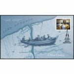
Description Chloe Cooley’s brave act of resistance on 14 MAR 1793, paved the way to freedom for so many Black enslaved men, women and children like her. This set the stage for the great freedom movement of enslaved African Americans known as the Underground Railroad. We will hike to where her bravery took place. This hike will take us along the General Brock Side Trail (GBST) and on then on the Niagara Parkway (NP). The GBST’s terrain is hilly/moderate, whereas the NP is flat/easy. We will then retrace our steps back.
The terrain may be icy and/or snow covered. Hiking poles and icers are advised, depending on the conditions.
PLEASE NOTE: This hike counts as 1 of the 3 required hikes towards the Black History badge. If you will have hiked 3 hikes in this series, and are interested in receiving a badge, remember to bring your $10. This applies to anyone who has not already received this badge.
For more information about Chloe Cooley click on the link below.
Description We will complete a loop hike on the mail Bruce Trail and side trails including the Great Esker side trail. Trail conditions are expected to be late winter/early spring. After the hike those interested are invited to meet at the Shepard’s Crook in Georgetown for refreshments.
Directions: From the 4o1 go north on Trafalgar Road pasts Georgetown. Trafalgar merges with Hwy 7 for about 3 km then separates to the right at the village of Silver Creek. From the stop light at Silver Creek go north on Trafalgar about 1 km to the entrance of Scotsdale Farm on your right. Drive in to the parking area about half a km.
Pace: Medium – 3 to 4 km/hr Terrain: Dependent on Conditions, Moderate – Some hills and/or some poor footing Distance: 11 kms
Description Hiking the main trail and side trails: Bennet Heritage Trail, Duff Pit, Reservoir, Trafalgar Rd and a bit of Great Esker. Through forest and meadow and on rocks and roots. Come with water, a snack and icers. If there is fresh snow, we can also snowshoe. I will send an email two days before the hike to confirm.
Hosting Club: Toronto Category: Urban Walk Location (Google Maps): 125 metres west of Dixon Road & Islington Avenue intersection, south side at entrance to Wincott Park. If arriving early, meet me at the Tim Hortons inside the No Frills Plaza SE corner at 10 am to use the washrooms and to stay warm. We will leave the Tim Hortons at 10:20 to walk to Wincott Park entrance. If driving to the hike, park on Northcrest Road, assessable via Fenley Dr and Poynter Dr from Islington Ave. Follow the path around the pond to the entrance of the park at Dixon Road to meet the group. Transit users can come either via Islington Bus 37 from Islington Subway running every 11 minutes or via Lawrence West Bus 52 to Pearson Airport running every 12 minutes.
Pace: Moderate Terrain: Flat, Variable Distance: 10 – 13 km
Description This is a partial repeat of my January hike along the little known Humber Creek, except that this time we will not be crossing the Humber River to the east side at Raymore Park but heading south along the Humber Trail to James Gardens and finishing at Historic Lambton House on Old Dundas Street. Lambton House is the last remaining building from the former Humber River hamlet of Lambton Mills and will be open for family St. Patrick’s Day festivities. For those interested in extending the hike, I will lead us another 3 km to Old Mill Road where those wanting to access the Subway can walk up to Old Mill Station and the rest of us wanting a post hike fellowship pub stop can join me at Bryden’s (Jane & Bloor).
Washrooms at Tim Hortons (0 km); James Gardens (7.5 km); and Lampton House (10 km)
Description The ‘green’ of St. Patrick’s Day reminds us of the Emerald Isle of Ireland, that spring is nearly here, and the importance of nature around us. Lucky us, to have the beauty of the Bruce Trail connected to the Glendridge Quarry Naturalization geosite and the work of the Niagara GeoPark that seamlessly connects our urban and natural environments. Come join us for a hike through this central geosite and along the Escarpment to Hydro Hill, and then back through the Brock Univeristy campus. The hike is organized for different abilities, and will provide parents and others the opportunity to adapt the hike to their physical needs. Listening to music from Ireland prior to the hike is recommended. Wear something green to welcome spring!
Pace: Leisurely: 3 km/h or less Terrain: Moderate: Some hills and/or poor footing Distance: 3 km
Description Deep snow will require snowshoes, icy conditions will require non-slip soles/icers.
We will carpool to Kemble and start of Nels Maher Side Trail which leads through mixed forest to join the main trail at km 143.9. First part is easy. The main trail skirts the escarpment crossing Kemble Rock Rd., and the Edmonstone Side trail at km 145.7 will return us to the parking area. We may see early wildflowers, as well as many fern species, including the at risk Hart’s Tongue Fern.
Pace: Medium – 3 to 4 km/hr Terrain: Moderate – Some hills and/or some poor footing Distance: 8-10km
Description We’ll walk between Hwy 6 and Waterdown road along the main trail. Some rocky terrain and hills. Recommend sturdy footwear/hiking boots with good tread. Hiking poles will be helpful and depending on the conditions icers. Dress in layers according to weather. Bring snacks and water
Description Hike the main and side trails of Short Hills Provincial Park. Bring hiking boots, icers and water. Last chance to log a hike to qualify for the Winter hiking badge. See website for details. https://niagarabrucetrail.club/badges/
Hosting Club: Caledon Hills Category: Tuesday Hikers Location (Google Maps): Pear Tree parking lot, 15 Sideroad. Driving directions: From Highway 401 going west, turn right (north) on Road 25, left on 15 Sideroad, drive about 300 m to Pear Tree parking lot on the left.
Hike Leader(s): Mohammad Shafiq
Pace: Medium – 3 to 4 km/hour Terrain: Moderate – some hills and/or some poor footing Distance: 10 km
Description Will hike southwards from the parking lot, main Bruce Trail, Al Shaw Side Trail and Vanderleck Side Trail to 17 Sideroad; after snack break will trace our steps back to the parking lot. Dress according to weather, poles are recommended. Bring water and snack of your choice. Hike leaders phone contact for hiking day: 416-566-0503
Hosting Club: Dufferin Hi-Land Category: Tuesday Hike Location (Google Maps): Dufferin Hi-land. Map 20. Meet at roadside parking on Prince of Wales Rd. (County Rd. 19) where the Primrose Loop Side Trail crosses Prince of Wales Rd. From Primrose (intersection of Hwy 10 and 89) drive north for about 1.5 km. Parking is about 0.7 km north of the bridge on the east side of the road.
Pace: Medium Terrain: Moderate, Slippery Sections Likely Distance: Long hike 7 km Short hike 3km
Description We will hike the Primrose Loop Side Trail on the west side of Prince of Wales Rd. Then, after crossing the road, we will head toward the Main Trail where we will turn left towards Murphy’s Pinnacle, climb to the top and take in the view. We will then return to Prince of Wales Rd. The short hike will end after completing the Primrose Loop Side Trail.
Icers are recommended. Bring water and snacks. Snowshoes may be needed if the snow is deep.
Optional refreshment stop at SuperBurger in Primrose after the hike.
Pace: Brisk – 4 to 5 km/hr Terrain: Moderate – Some hills and/or some poor footing Distance: 12 km
Description CONTACT Hike Leader to get directions for meet-up point. Three steep climbs makes for a very challenging hike. Footing is generally good but we may encounter some spots that are tricky along the way and some road hiking. Terrain includes shale and sandstone. We will include Russ McConnell Side Trail, John Haigh Side Trail and Pretty River Side Trail at some point along the way when you are least expecting it. It is always a strenuous and fulfilling adventure. Bring a snack or lunch and water.
Hosting Club: Niagara Category: Car Pool Location (Google Maps): Meet at the Parking Lot at Port Dalhousie Parking Lot and Car pool to Book Depot , 67 Front St North Thorold, 43.128058, -79.202189
From Jordan Hollow Hike the main trail to Upper and Lower Balls Falls, Moyer Road or Louth and Return. You must register for each hike. Bring Poles, sunscreen, bug spray , snack and a drink and dress for the weather
Pace: Medium – 3 to 4 km/hr Terrain: Dependent on Conditions, Moderate – Some hills and/or some poor footing, Slippery and Steep Sections Distance: About 8 kms
Description We will hike along the main trail alongside the beautiful Grindstone Creek and around a couple of the bike trails and back to the main trail. There are some steep sections along this trail and possibly some icy places, depending on how much snow is still on the trail. Bring icers just in case. I will send an email two days before the hike to confirm.
Description Each Friday we will explore different neighbourhoods, trails and parkland throughout Historic Niagara-on-the-Lake.
Moderate pace with some weeks entirely on sidewalks and roads while others may include a mix of trails and paved pathways. Great way to build up endurance for longer more strenuous hikes.
Prepare for cooler windy conditions on open parkland and along Lake Ontario and Niagara River trails.
Plan to stay for conversation and a warm cup of coffee or tea at Sweets & Swirls, Community Centre, Niagara Stone Road, NOTL
Description Starting on the Borchardt Rd parking lot (km 108.7), we will follow the Minhinnik ST to the Lillie Family parking area on Britain Lk Rd at the Cotrill Lake ST (110.8 km) we will loop around the Cotrill Lk ST spending time on the shores looking for the arrival of water fowl. On the return trip to the cars, we will follow the Main Trail South, looking for grebes, loons and other shoreline birds that frequent Dyers Bay. We will visit the Devil’s Monument viewing platform, and check out the waterfall before heading back to the parking lot along Devil’s Monument ST and the Minhinnik to Borchardt Rd. Throughout our hike, we will keep an eye out for the arrival of spring flowers and other harbingers of spring. This route is quite rocky in places with stairs. The Trail may be wet and muddy around Cotrill Lake. We will be taking stairs down to the viewing platform and the waterfall. Total distance is around 8 km. This hike may take 3 hours to complete. Pack snacks and drinks accordingly.
Pace: Leisurely: 3 km/h or less Terrain: Easy: Mostly flat and good footing., Moderate: Some hills and/or poor footing, There might be muddy sections. Distance: 5.0 km approx
Description We will make a balloon loop through this beautiful forest reserve from Concession 24 road allowance access. Water and snacks as needed. Text or call hike leader 226-787-8804 for any questions or if unable to register.
Description This is the first of three hikes to hike the Toronto section E2E. We will be hiking in early spring conditions (mud, ice, snow) so be prepared for it all. Please bring your icers, gaitors, and poles. Hiking boots/shoes are mandatory. Please bring at least 2L of water, snacks, and your lunch.
We will be shuttling to Hilton Falls CA parking, close to Appleby Line, and hiking by the location of the first blaze on the Bruce Trail. Please note, we will need to pay for parking at Hilton Falls. If any hiker has an annual pass, please let me know. Pass holders can do this shuttle and the rest of the hikers are expected to pay the driver $2. If there are no pass holders, hikers will share the cost of the parking. Hikers are expected to follow all Covid 19 restrictions.
Please arrive by 8:00 so we can get organized. We will begin our shuttle at 8:15 am.
Location (Google Maps): Meet at Bethesda Trail Head Parking on Bethesda Sideroad off Bayview Avenue, across from Lake Wilcox. This parking lot is free.
Description Join us to explore Jefferson Forest and Bond lake ,
Please bring hiking poles, proper closing and shoes and lots of water,
Please carefully read safety procedures during the hike:
1-Hikers must stay between the leader and the sweep.
2-Hikers must advise the leader or the sweep if they wish to leave the group.
3- Hikers must follow the whistle instructions: 1 blast- stay where you are; 2 blasts come to the leader; 3 blasts – come to the leader quickly.
4-Hike leader may request volunteers to stop at trail intersections, they need to help hikers to the direction the group walk and wait till they see the sweep .
5-Hikers have to make sure they can see the persons behind and in front of them.
Description On March 14, 1793 Chloe Cooley, an enslaved Black woman living in Queenston, strongly resisted as she was bound, thrown in a boat and taken across the river to a new enslaver in the United States. On 21 MAR, 1793, two men testified to her capture at the Executive Council of Upper Canada (at Navy Hall). Her brave act of resistance led to the 1793 Act to Limit Slavery, the first of its kind in the British Empire. This paved the way to freedom for so many others like Chloe & set the stage for the great freedom movement of enslaved African Americans to Canada.
Participants will walk along the Niagara Parkway to a plaque that marks the place where this incident may have place, then return along the same route with a stop at Navy Hall, the site where Executive Council met.
Open the link below to view the Chloe Cooley Heritage Minute.
https://www.youtube.com/watch?v=cLPMlNSQjOg
*This hike counts as 1 of 3 required hikes towards the Black History badge. If you have met the requirements, and are interested in a badge, please remember to bring $10.*
PLEASE NOTE: Hikes are offered by BTC volunteers who have committed to their own learning, to be able to offer informative and contemplative hike experiences. These hikes are open to all & offered in a spirit of mutual leaning and inclusion.
Description This challenging “hike” is intended for those wishing to train for future challenging hikes. Choose your own pace to go up and down the moderately steep hill for 90 minutes with a brief flat walk partway through. The terrain is a hard packed gravel surface. Bring water, hiking poles, snack and dress for the weather.
Hosting Club: Blue Mountains Category: Register in person the morning of hike. Location (Google Maps): Hike meets in the parking lot behind Tim Hortons on First St. in Collingwood.
Pace: Medium – 3 to 4 km/hr Terrain: Moderate – Some hills and/or some poor footing Distance: 8 km
Description We will park at km 91.9 on Sideroad 16C in the Beaver Valley section. We will follow the white blazed trail north to km 94.9 and return via the Sligo Side Trail to the cars. The trail meanders through varied wilderness terrain that includes extensive wetlands, a large beaver pond, deciduous forest, spruce and pine plantations and an old forest road. Bring a snack and water.
Hosting Club: Iroquoia, Toronto Category: General Hike Location (Google Maps): Parking capacity is in brackets. March 23 – Meet on 3rd line (Charles Hildebrandt Side Trail)) – 15kms March 24 – Meet at Scottsdale Farm on Trafalgar Rd Parking Lot – 14.4kms March 30 – Meet at Roadside pkg at Boston Mills Rd just west of the Mississauga Rd intersection. Note: Driveway is private property . 43.750866, -79.951452 (5) 17km
Pace: Medium – 3 to 4 km/hr Terrain: Moderate – Some hills and/or some poor footing Distance: Varies – two long days and one short one.
Description Join us for this special 3 day Toronto End to End this spring on March 23, 24, and 30, 2024. The hikes will be at a moderate pace 3-4km per hour. This is suitable for intermediate to advanced hikers.
We will be using hiker’s vehicles to shuttle between to our start from our meeting point. As well, there will be entry costs at Hilton Falls. (If you are a member of Halton Conservation, please bring your pass). Costs will be shared amongst the hikers unless you have a pass.
Proper hiking boots is a must! Bring hiking poles (if you use them), food, snacks, 2l of water, hat, and rain gear. It may be cool, wet or warm. Please check the weather forecast each day before heading out.
Arrive by 9:30 am to check in. Once everyone has arrived, we will proceed and drive to the starting point.
Your fee includes the guidance and organization of a volunteer hike leader. Everyone will receive their Stained-glass End to End badge upon completion which depicts the historic Limehouse Arch. If you must miss a day but can make it up before the last scheduled hike, you will still qualify for this special badge. This is a fundraising hike for the Bruce Trail Club. Proceeds go to the Toronto Club to support the trail infrastructure and to the Bruce Trail Conservancy mission “Protecting this ribbon of wilderness, for every one, forever.”
Please, no dogs or children.
There are no refunds for this hike series. Please ensure you are physically capable of these distances before signing up for this hike.
If you have any questions, please enquire to the hike leader through this form.
Location (Google Maps): There is a long driveway up to the house, some cars will park at the top, when that’s full, others will park along the driveway. The property is located at 496101 on the Eastside of Grey Rd 2. – exactly 1k North of the Ravenna Country Market.
Pace: Medium Terrain: Moderate Length of Hike: Approx. 4 km, about 1 1/2 hours
Description SOUP’S ON! Join us for a lovely snowshoe on the property of Larry & Barb Hall, where we’ll hike through well laid out trails to see some wonderful views. Afterward we’ll enjoy a warming lunch in their home. They will provide the soup, plus coffee & tea and you’ll bring a sandwich, or your choice of accompaniment to go with it. If you’d like to bring goodies to share for dessert, feel free! Folks are welcome to show up just for the lunch, or conversely, just for the hike. If you are there just for lunch, please arrive about 12:00p.m. We may still be on the trail. Depending on the conditions, we may use snowshoes, icers or just boots, so please come prepared. If you have any questions please contact beavervalleytrailactivities@gmail.com. The hike leader will inform the group in the morning on Mar. 23 if weather conditions preclude the hike. Hope to see you there! Please car pool if possible.
COVID-19 Precautions for your Hike
Each hiker joining a Bruce Trail Club organized hike must perform a self-screening check before hiking. Find Ontario’s self-assessment tool here: https://covid-19.ontario.ca/self-assessment/
If you are experiencing COVID-19 symptoms, stay home.
Transportation
All hikers are responsible for their own transportation to and from the hike.
Currently, there are no car shuttles on hikes – all hikes must be out-and-back or loop hikes.
Other Guidelines
Arrive 15 minutes before the start of the hike.
Wear sturdy footwear and appropriate attire for the weather and the terrain. Hiking poles are a good idea in any season, especially if the terrain is rocky or slippery. In winter, snowshoes or icers/crampons are needed when conditions dictate. Wearing appropriate clothing and footwear prevents injuries and shows consideration for a safe and positive group hiking experience.
Always carry I.D. and your health card.
Bring sufficient water and snacks (or lunch if indicated). A minimum of 1L of water is recommended on all hikes, and 3L is recommended for long, challenging hikes in the heat of the summer.
Bring sunscreen and insect repellent (for spring and summer hikes).
Hosting Club: Toronto Category: Urban Walk Location (Google Maps):
NE Corner Yonge & Lawrence (by subway exit)
Hike Leader(s): Tom Swales
Pace: Moderate Terrain: Variable Distance: 12 KM
Description Join us for a hike through ravines from Yonge & Lawrence to Sunnybrook & Serena Gundy parks to end at Brentcliffe & Eglinton. Those who wish may continue to a refreshment stop at the Longo’s on Laird Ave. All are welcome but proper ice traction footwear (icers) is mandatory for safety reasons.
Pace: Medium – 3 to 4 km/hr Terrain: Strenuous – Hilly with steep climbs and some poor footing Distance: 6.5
Description We will meet at the roadside parking where the Bruce Trail crosses Guelph Line, south of No. 1 Sideroad. Please do not block the farm gate.
We’ll be hiking along the main trail to the Fisher’s Pond Side trail, making a loop around the pond, then returning back along the same trail to our cars.
Bring water, snacks, and clothing layers. Poles are optional. Depending on trail conditions, icers may be helpful, especially as there are some hills.
Boots are advised as there may be some muddy sections.
Please arrive at 8:45 am as we will leave promptly at 9:00 am.
Please check email before leaving home. Please contact the hike leader if you need to cancel last minute. Thank you.
Pace: Medium Terrain: Difficult, Moderate Distance: 14 Approx.
Description This hike is through the mature forest of Hope Bay Forest Provincial Nature Reserve. We will hike the Hopeness, Jack Poste and Don Irish Side Trails and loop back on the main trail for some gorgeous lookouts overlooking the Hope Bay.
Dress according to weather. Bring water, lunch and wear appropriate footwear for rugged terrain.
Pace: Medium – 3 to 4 km/hr Terrain: Dependent on Conditions, Moderate – Some hills and/or some poor footing Distance: 8 kms
Description Hiking the bike trails, side trails and main trail to Waterdown and back for a good loop. Mostly good footing with some rocky sections on the main trail. Please bring icers. If there is fresh snow, we can snowshoe. I will send an email two days before the hike to confirm.
Hosting Club: Toronto, Dufferin Hi-Land Category: Car Hike Location (Google Maps): We will meet at Mono Cliffs Provincial Park at 795086 3rd Line EHS (Map 19 of the Bruce Trail Reference Guide, Edition 31). Note that reservations and fees apply to this parking lot.
Description Calling all families with children who love hiking and earning badges!!!
This is the third in a series of ten hikes that will be offered throughout 2024 on a roughly monthly basis so that children who are 15 years of age and younger can earn the Dufferin Hi-Land Adventurer Youth Badge and their parents/guardians can earn the Dufferin Hi-Land Side Trails Badge at the same time!!! Details regarding the requirements for each badge can be found here: https://dufferinbrucetrailclub.org/dufferin-bruce-trail-club-badges/ Each of the ten hikes will be a loop hike so no car shuttles will be needed, and each hike will cover a distance of approximately 6-9 km hiked at a leisurely pace (2-3 km/h) so children and adults alike can participate.
This third hike will be a late winter/early spring hike to explore some side trails within and south of Mono Cliffs Provincial Park, specifically the Carriage Side Trail, the South Outlier Connector, the South Outlier Loop Trail, and the Whitetail Refuge Side Trail (this last side trail is part of the Caledon Hills section of the Bruce Trail). Please dress appropriately for a late winter/early spring hike by dressing in layers (wear an inner layer that wicks sweat away from your skin, a middle layer that keeps you warm, and an outer layer that protects you from wind and snow), wearing gloves/mittens and a toque, and wearing warm and comfortable footwear that has good traction in snow/ice (icers placed over your boots work great!). Hiking poles or walking sticks are an asset since they will help keep you balanced if the ground is slippery. As well, make sure you bring enough water and food for a 3-4 hour hike since we’ll be covering a total distance of approximately 9 km.
*Please note that this hike will begin at a later time than the other hikes in this series because it involves a paid parking lot at Mono Cliffs Provincial Park with set time slots. I will email people registered for this hike five days before the day of the hike so they can reserve their parking space at Mono Cliffs Provincial Park beforehand. The cost to park for a 4-hour time slot at Mono Cliffs Provincial Park is $8.50.
Hopefully you’ll be able to join me on Sunday, March 24th! Until then, happy hiking, everyone!
Hosting Club: Sydenham Category: Snowshoe Hike Location (Google Maps): Meet in the north-east corner of the parking lot at Home Depot on Highway 26 on the east side of Owen Sound.
Pace: Leisurely: 3 km/h or less Terrain: Easy: Mostly flat and good footing. Distance: 2.7 km
Description Carpool to Sydenham Forest East Side Trail and then snowshoe the Exploring Sydenham loop 15 / Looping Though Sydenham 2nd edition loop 9. This winds mostly through bush that should provide some protection from the weather. If unable to register or for information contact Bill Snel at w.snel2@gmail.com or landline (519) 470-0584.
Pace: Medium – 3 to 4 km/hr Terrain: Dependent on Conditions, Moderate – Some hills and/or some poor footing Distance: 10km
Description
Meet in the parking lot next to the Hidden Valley Park Washrooms at 9:45 for a 10:00 am start. This is a 10 km loop hike. Hike distance will be reduced if hiking conditions are poor. Dress appropriately for the weather and for slippery trail conditions. Bring food and water, hiking boots, and icers. We begin the hike by walking in a north westerly direction along Grindstone Creek on Hidden Valley Road. We hike local trails along the east side of Grindstone Creek and then cross Grindstone Creek when we join the BTC main trail. The hike will take us through Clappison (Black) Woods and ends with a walk along Lemonville Road back to our cars. Participants with a sweet tooth can request a stop at the enormous candy store on Sumach Dr. near the end of the hike.
Description Moonlight Night Hike – Take in the magic of the rising moon over Lake Ontario and the Niagara River. This hike includes a stop to connect with your senses – sights, sounds, smells and the rhythm of your breath. Counts towards your night hike badge (5 night hikes).
Hosting Club: Caledon Hills Category: Tuesday Hikers Location (Google Maps): Scotsdale Farm parking lot. From Highway 401 go north on Trafalgar Rd. until it merges with Highway 7, turn left on Highway 7, after about 4 km Trafalgar Rd. will branch-out to the right, take Trafalgar Rd., entrance to Scotsdale Farm is on the right after about 1.5 km. An unpaved road leads to the parking on the left.
Pace: Medium – 3 to 4 km/hour Terrain: Moderate – some hills and/or some poor footing Distance: 11 km
Description Will go on main Bruce Trail and side trails in Scotsdale and Silver Creek Conservation Area, Duff Pit, Reservoir, Maureen Smith and parts of Bennett Heritage in a loop. Bring water, snack. Poles and gaiters are recommended. Dress according to weather, in layers. Hike leader’s contact # 416-566-0503
Hosting Club: Sydenham Category: General Hike Location (Google Maps): Meet at Bruce Trail Parking at the Massie Hills Management Area. This is on the west side of 6th Concession South, south of Side Road 6, north of Side Road 3. From here we will do a short car shuttle to the Bighead River on 4th Concession South
Pace: Brisk: 4 to 5 km/h Terrain: Strenuous: Hilly with steep climbs and some poor footing. Distance: 6.5 km
Description Our hike starts in the Bighead River Valley. This portion may be muddy, depending on weather conditions, so waterproof boots are a must, and gaiters are recommended. We then enjoy a long, steep climb up the escarpment and will be rewarded with lovely views across the fields to the south. We’ll travel beside pastures and hike through a forest. We finish the hike with a lovely loop in the Massie Hills area. Please note that due to the length and steepness of the climb, this hike is suitable for fit and experienced hikers.
Pace: Brisk Terrain: Moderate, Some rocky footing, Some steep sections Length of Hike: approx. 20 km per hike
Description This series of hikes will be held on 4 Tuesdays (March 26, April 2, 16 & 23) If you complete all 4 hikes you will qualify for 2 badges at $10 each.
Conditions will be difficult due to spring weather. Please ensure you are physically able to hike at a brisk pace (4-5km/hr) for a minimum of 5hrs.
Please dress according to the weather presented that day. Bring enough food and water (electrolytes) for a long day of hiking.
This is a car shuttle hike. Please have your vehicle passenger ready as everyone will be taking a turn either to hike start or getting drivers back at end of day.
Please arrive 15 min ahead of time.
No Dogs allowed
A schedule will be sent out to registered participants a week prior to the first day.
COVID-19 Precautions Before, During and After your Hike
Each hiker joining a Bruce Trail Club organized hike must perform a self-screening check before hiking. Find Ontario’s self-assessment tool here: https://covid-19.ontario.ca/self-assessment/
If you are experiencing COVID-19 symptoms, stay home.
Transportation
It is the Bruce Trail Conservancy’s current policy that car shuttles are allowed. It is at the discrepancy of individual hike leaders to make that decision.
Other Guidelines
Arrive 15 minutes before the start of the hike.
Wear sturdy footwear and appropriate attire for the weather and the terrain. Hiking poles are a good idea in any season, especially if the terrain is rocky or slippery. In winter, snowshoes or icers/crampons are needed when conditions dictate. Wearing appropriate clothing and footwear prevents injuries and shows consideration for a safe and positive group hiking experience.
Always carry I.D. and your health card.
Bring sufficient water and snacks (or lunch if indicated). A minimum of 1L of water is recommended on all hikes, and 3L is recommended for long, challenging hikes in the heat of the summer.
Bring sunscreen and insect repellent (for spring and summer hikes).
Pace: Medium Terrain: Dependent on Conditions, Easy, Slippery Sections Likely Distance: 6 km
Description From the parking lot off hwy 50, we will hike through the Palgrave Forest on the many trails available, returning to the parking lot. Dress for the weather, and bring along a snack. Icers and/or snowshoes may be required.
Hosting Club: Caledon Hills Category: General Location (Google Maps): Roadside parking on Coolihans Sideroad (east of Airport Rd.) and east of where the trail crosses the road; km 35, Map 17.
Pace: Leisurely – 3 km/hour or less Terrain: Moderate – some hills and/or some poor footing Distance: 6 km
Description Join Marilyn, Louise and Joyce on this 2 hour, 6 km hike which is the 2nd in the series of hikes for the new “60 for the 60th Anniversary” badge. We will hike south along the main trail and back. Hike one, a few, or all 10 hikes. Join any hike and make up the rest on your own as long as a record is kept of their hikes to submit on completion to obtain their badge. Participants who complete all 10 hikes will be eligible to purchase the “60 for the 60th” badge. Bring icers, poles, and hydration.
Description From the Lionsclub pool the hike will take us up the escarpment to th conservation area where we will loop through the CA and out to view the waterfall and back
Hosting Club: Blue Mountains Category: Register in person the morning of hike. Location (Google Maps): Hike meets in the parking lot behind Tim Hortons on First St. in Collingwood.
Pace: Medium – 3 to 4 km/hr Terrain: Moderate – Some hills and/or some poor footing Distance: 12 km
Description An enjoyable snowshoe along the white blazed trail through the upper escarpment, descending to the Standing Rock Side Trail where the trail becomes more challenging and quite the climb. An enjoyable view of Standing Rock in all its magnificence, then up and over icy rock faces and through icy cracks and crevices. Once at the top continue on to close the loop. Take the Franks Kiln Side Trail just before you reach the end of the loop to view a restored lime kiln that was originally built circa 1860.Bring a snack or lunch and water.
Pace: Medium Terrain: Moderate Length of Hike: Approx. 7 km
Description This hike takes us into the Bayview Escarpment Nature Reserve in the Sydenham section of the Bruce Trail. We travel through mixed hardwood forest with views over Georgian Bay, then return on the Bayview Escarpment side Trail. On winter hikes we may encounter bare ground, light snow, deep snow, or ice. Please bring snowshoes and icers to our Winter Wednesday Walkers outings. Wear appropriate clothing for the weather plus water and a snack.
COVID-19 Precautions Before, During and After your Hike
Each hiker joining a Bruce Trail Club organized hike must perform a self-screening check before hiking. Find Ontario’s self-assessment tool here: https://covid-19.ontario.ca/self-assessment/
If you are experiencing COVID-19 symptoms, stay home.
Other Guidelines
Arrive 15 minutes before the start of the hike.
Wear sturdy footwear and appropriate attire for the weather and the terrain. Hiking poles are a good idea in any season, especially if the terrain is rocky or slippery. In winter, snowshoes or icers/crampons are needed when conditions dictate. Wearing appropriate clothing and footwear prevents injuries and shows consideration for a safe and positive group hiking experience.
Always carry I.D. and your health card.
Bring sufficient water and snacks (or lunch if indicated). A minimum of 1L of water is recommended on all hikes, and 3L is recommended for long, challenging hikes in the heat of the summer.
Bring sunscreen and insect repellent (for spring and summer hikes).
Bring your own first aid kit.
Please leave dogs at home.
On winter/early spring hikes we may encounter bare ground, light snow, deep snow, or ice. Please bring snowshoes and icers to our Winter Wednesday Walkers outings. Wear appropriate clothing for the weather plus water and a snack.
COVID-19 Precautions Before, During and After your Hike
Each hiker joining a Bruce Trail Club organized hike must perform a self-screening check before hiking. Find Ontario’s self-assessment tool here: https://covid-19.ontario.ca/self-assessment/
If you are experiencing COVID-19 symptoms, stay home.
Other Guidelines
Arrive 15 minutes before the start of the hike.
Wear sturdy footwear and appropriate attire for the weather and the terrain. Hiking poles are a good idea in any season, especially if the terrain is rocky or slippery. In winter, snowshoes or icers/crampons are needed when conditions dictate. Wearing appropriate clothing and footwear prevents injuries and shows consideration for a safe and positive group hiking experience.
Always carry I.D. and your health card.
Bring sufficient water and snacks (or lunch if indicated). A minimum of 1L of water is recommended on all hikes, and 3L is recommended for long, challenging hikes in the heat of the summer.
Bring sunscreen and insect repellent (for spring and summer hikes).
Pace: Medium – 3 to 4 km/hr Terrain: Dependent on Conditions, Moderate – Some hills and/or some poor footing Distance: 7.5 km
Description We will follow the Red Hill Creek Trail and Bruce Trail to Felker’s Falls and follow a similar route back to the parking lot. Bring water,a snack and icers (as a precaution- unlikely to be needed). Trails may be muddy and slippery so poles may be needed. Please arrive by 9:45 am as we will be on the trail by 10:00 am sharp.
If cancelled due to rain, I will notify you by email the evening prior to the hike. If you cancel after 4:00 pm on the day prior to the hike, use the contact information I will send you by email a day or two before the hike.
From Jordan Hollow Hike the main trail to Upper and Lower Balls Falls, Moyer Road or Louth and Return. You must register for each hike. Bring Poles, sunscreen, bug spray , snack and a drink and dress for the weather
Pace: Medium – 3 to 4 km/hr Terrain: Dependent on Conditions, Moderate – Some hills and/or some poor footing Distance: About 8 kms
Description We will hike around several of the bike trails. There may be snow, so bring icers. I will send an email two days before the hike to confirm.
Pace: Leisurely – 3km/hr or less Terrain: Dependent on Conditions, Moderate – Some hills and/or some poor footing Distance: 9-10 km.
Description Join in for a there and back hike to the old Duff Pit Quarry and the old Georgetown Reservoir. Meet at 9:45 am. for a 10;00 am. start in the main parking lot of Scotsdale Farm, just off of Trafalgar Rd., on the east side. Careful, it is easy to miss the entrance. We will use main trail to hike west to pick up the blue side trail leading to Duff Pit and the Reservoir trail. If time allows and we’re up for it we can add an extra loop before heading back to the farm. Bring water, a snack and poles if using. Icers may be necessary. Leader: Anne Armstrong
Pace: Brisk Terrain: Challenging, Variable Distance: 20.7 km
Description The first of 8 hikes to complete the Sydenham section. We will carpool to km 0.0 and hike back. Bring icers, 2litres of water. We will follow all Covid 19 instructions. Please arrive at 8:15 so the shuttle can leave by 8;30. Expected pace is 4- 4.5 km per hour.
Description Each Friday we will explore different neighbourhoods, trails and parkland throughout Historic Niagara-on-the-Lake.
Moderate pace with some weeks entirely on sidewalks and roads while others may include a mix of trails and paved pathways. Great way to build up endurance for longer more strenuous hikes.
Prepare for cooler windy conditions on open parkland and along Lake Ontario and Niagara River trails.
Plan to stay for conversation and a warm cup of coffee or tea at Sweets & Swirls, Community Centre, Niagara Stone Road, NOTL
Pace: Moderate Terrain: Flat, Variable Distance: 16.71 km
Description Discover Georgina with an exploratory trip to Georgina’s lakeshore along Lake Simcoe and the Metro Road Tract trail in York Region. https://onthegomap.com/s/1r6ogqb7
Meeting point: Yonge Street and Steeles Avenue intersection northbound bus stop (If coming from the subway you may choose to board the bus at Finch bus terminal and meet at the next transfer stop or the starting point of the walk/hike)
Transit: York Region Transit Viva Blue bus
Commuting route (to destination):
blue, Yonge / Steeles to Yonge / Davis Northbound, 9:32 AM – 10:32 AM 050, Davis Dr / Yonge St to Metro Rd / Dalton Rd, 10:37 AM – 11:41 AM
Commuting route (return trip):
050, Metro Rd / Lake Dr N to Davis Dr / Yonge St, 4:11 PM – 5:06 PM blue, Yonge / Davis Southbound to Finch, 5:15 PM – 6:30 PM
Distance: 16.71 km
Pace: 4 km/hour
Note: Please be advised that the commuting time is +2 hours each way.
Description Let’s launch the Spring & Migration Monitor Hikes with an easy, low-impact, out and back stroll along the Cape Chin Drive Way to the Cape Chin Point. This will be a weather dependent hike. We will take a break at Cape Chin to observe the changing shoreline that stretches to the South. Will the Sandhills have returned to the Cape Chin wetlands? Bring you binoculars and keen sense of observation. Open to everyone!
Hosting Club: Toronto Category: Car Hike Location (Google Maps): We will again meet at km 17.4 (GPS N43.615163, W79.975157) on the east side of the road where the trail crosses Fourth Line and do our shuttle from there.
Description This is the second of three hikes in this series to complete the Toronto E2E. We will be hiking in early spring conditions (mud, ice, snow) so be prepared for it all. Please have your icers, gaitors, and poles at the ready. Hiking boots/shoes are mandatory. We will stop for snacks and lunch so bring 2L of water, snacks, and your lunch.
We will be shuttling to our starting point so pleased be prepared participate in the shuttle. All Covid 19 restrictions will be followed.
Today we will be hiking past the “Hole in the Wall” in Limehouse.
Pace: Brisk Terrain: Challenging, Variable Distance: 21.4 km
Description 2nd hike of 8, we will carpool to km 41,7 and hike back. Bring icers and 2 litres of water. We will follow all Covid 19 instructions. Please arrive 15 minutes early, so the car shuttle can leave by 8:30. Everyone is expected to participate in car shuttle throughout the 8 days. Expected pace is 4- 4.5 km per hour moving time.
Hosting Club: Dufferin Hi-Land Category: General Hike Location (Google Maps): Mono Community Centre, 200m south of Mono Centre (County Road 8). Park in gravel lot. Please be there for 8:45 am.
Pace: Medium Terrain: Slippery and Steep Sections, Strenuous Distance: 19.5 kms
Description Join us for a challenging but rewarding shuttle hike from the new BTC Riverside Woods Reserve property in the Hockley Valley to Mono Centre. There will be a lot of hills but the woods will be beautiful. We will take in no fewer than 8 side trails! Please be prepared to use your vehicle to shuttle fellow hikers and please bring a garbage bag and change of footwear to keep the cars clean. It will be muddy. Hiking boots mandatory. Please pack icers just in case. Gaiters and poles recommended. Please bring 2L of water, a warm drink, a snack, a lunch and a smile. Please meet at 8:45 to be ready to shuttle at 9 am sharp. We will keep moving but there will also be plenty of time to stop and smell the roses.
Hosting Club: Blue Mountains Category: Register in person the morning of hike. Location (Google Maps): Hike meets in the parking lot behind Tim Hortons on First St. in Collingwood.
Pace: Leisurely – 3 km/hr. or less Terrain: Easy – Mostly flat and usually good footing Distance: 5 km
Description We will drive to the Blue Mountains/Clearview Townline, north of County Road 91 and park at Eagle Cres for a hike through the Nottawasaga Lookout Nature Reserve. We will start the hike at km 42.5 and hike through the woods for about an hour before retracing our steps. Bring a snack or lunch and water.
Pace: Moderate Terrain: Flat, Hilly, Variable Distance: 16.79 km
Description Discover Newmarket, East Gwillimbury, and King City with an exploratory trip to Peggy’s Wood, Dave Kerwin Trail and the Thornton Bales Conservation Area (99 Steps) in York Region. https://onthegomap.com/s/5ckipp28
Meeting point: Finch Bus Terminal
Transit: York Region Transit Viva bus
Commuting route (to destination):
blue, Finch to Newmarket Terminal, 9:14 AM – 10:23 AM
Commuting route (return trip):
057, Bathurst St / Keith Av to Newmarket Terminal, 3:16 PM – 3:23 PM blue, Newmarket Terminal to Finch, 3:36 PM – 4:58 PM
Distance: 16.79 km
Pace: 4 km/hour
Note: Please be advised that the commuting time is +1 hours each way.
!!! Beware of steep incline in the Thornton Bales Conservation Area (99 Steps): The change in vertical elevation from the top of the 99 steps to the bottom is a larger change in elevation than the drop over Niagara Falls!
Description This hike follows the 9/11 Memorial Trail, the Waterfront Trail, the northernmost portion of the Greater Niagara Circle Route and the George Nicholson Memorial Trail. Hikers will have lovely views of Lake Ontario. Trails are generally wide dirt paths, with the exception of the 9/11 Memorial Trail which is gravel. Short portions of the hike follows city streets.
Prepare for cooler windy conditions on open parkland and along Lake Ontario.
See the link below for information about the 9/11 Memorial Trail.
Description We will hike the Caledon Rail Trail from Mississauga Road to Caledon East. This hike is intended to get us started on the spring hiking season. Hiking boots are recommended but not essential. Trail conditions should be mostly dry depending on weather.
From Caledon East we car pool to Mississauga Road and hike back. The hike passes through Inglewood and natural areas. East of Hwy 10 we pass through a swampy area frequented by beavers. We will also pass a remnant of the past when railways held our country together. After the hike you may join other hikers for a coffee at the Four Corners Cafe.
To get to the meeting point drive north on Airport Road from King Street in Caledon. Turn right on Old Church Road and go less than 1 km to the Town Hall (on your right). Meet other hikers at the south west corner of the parking area
Description An Easter Saturday hike. We start at Old Mill subway Station and walk upstream along the Humber River. I expect to hear lots of birds in James Gardens. When we arrive in Weston at end of hike around 12:30 PM a Pizza Pizza, Tim Hortons as well as other restaurants are nearby if you have not brought a lunch to eat in Weston Lions Park.
To travel by transit back home from Weston Lions Park, there is an Eastbound Eglinton West #52 bus to Lawrence West subway or Lawrence subway station. There is also the Southbound Weston #89 bus to Keele subway station. To travel to Union Station the Weston UP Express or GO station is just East of Weston Road.
Pace: Brisk Terrain: Challenging, Variable Distance: 20.51 km
Description The 3ed of 8 hikes to complete the Sydenham E2E. We will carpool to km 62.4 and walk back. Bring icers and 2litres of water. We will follow all Covid 19 instructions. Please arrive at 8:15 so the shuttle can leave at 8:30. Expected pace is 4- 4.5 km per hour. Everyone is expected to participate in the car shuttle during the 8 days.
Hosting Club: Iroquoia Category: General Hike Location (Google Maps): Meet roadside on 15 Side Road at Speyside at 9:15 am. We will carpool to 22 Side Road to start the hike.
Pace: Medium – 3 to 4 km/hr Terrain: Dependent on Conditions, Moderate – Some hills and/or some poor footing Distance: 8 kms
Description Meeting roadside on 15 Side Road, just off Hwy 25 at Speyside, we will carpool to 22 Side Road and hike back along the Canada Goose Side Trail to the main trail. Turn onto the Cliff Hatch Side Trail and finish along the Speyside South Side Trail to the cars. This hike has a lot of technical sections (rocks and lots of them), so be prepared for that. It’s a wonderful challenge! I will send an email two days before the hike to confirm.
Description Please join me at the south west corner of Finch and Weston by 10 AM. We will hike south on the Humber Recreational Trail to Scarlet and Eglinton (km 30.2 to km 19.2). Here is an online map with km markings of our route for all 7 hikes for the Toronto Urban Badge.
Please make sure you bring at least 2 liters of water, a lunch, bug spray and sunscreen.