Hosting Club: Caledon Hills Category: Car Hike Location (Google Maps): Meet at Rock Chapel Nature Sanctuary parking — Map 9, km 62.0. From Hwy 403 take Hwy 6 north 3 km to Dundas St. Turn left. Follow for 2 km and turn left on Rock Chapel Rd. Follow 1.5 km to PAY parking on left.
Description From Borer’s Falls we will hike east on the Trail under Hwy 6, through Clappison Woods as far as Snake Rd and then return. Possibly a side trip on the Rockcliffe Side Trail (720 meters).
Hike will be shortened if the weather is very hot.
Description Sunset & Moonrise Night Hike – Take in the magic of the setting sun and rising moon over Lake Ontario and the Niagara River. This hike includes a stop to connect with your senses – sights, sounds, smells and the rhythm of your breath. Counts towards your night hike badge (5 night hikes).
Hosting Club: Blue Mountains Category: Register in person the morning of hike. Location (Google Maps): Hike meets in the parking lot behind Tim Hortons on First St. in Collingwood.
Pace: Leisurely – 3 km/hr. or less Terrain: Easy – Mostly flat and usually good footing Distance: 5km
Description Hike this 204 acre property featuring majestic mature sugar maple trees and a meandering cold water stream. This lush Niagara Escarpment forest is home to a variety of rare and at-risk species. The sounds of hairy and pileated woodpeckers echo through the trees. We will creatively combine Mingay, Maple Leaf and Trout trails to complete a loop-de-loop. Bring a snack and water.
Pace: Leisurely Terrain: Easy, Moderate Length of Hike: 3.9 km
Description An enjoyable walk with lots of opportunities for stops and photos. We’ll walk by a creek, view a flowerpot and a waterfall, and see the E.C. Carr Observatory buildings along our route. Country laneways with farm views, as well. Please bring water and a snack.
Hosting Club: Sydenham Category: An evening walk. Location (Google Maps): Meet in the municipal parking lot by the river on the west side of 1st Ave. E between 7th St. E and 8th St. E in Owen Sound.
Pace: Brisk: 4 to 5 km/h Terrain: Easy: Mostly flat and good footing. Distance: Approx 5 km
Description Join us for an evening hike exploring trails & neighbourhoods in Owen Sound followed by an opportunity for refreshments. No need to arrive 15 minutes early. The hike will leave at 7:00 pm. For further information or if you are unable to register, contact Hike Leader Harriet Nixon at harrietnixon@bmts.com or cell 519-373-6598
From Jordan Hollow Hike the main trail to Upper and Lower Balls Falls, Moyer Road or Louth and Return. You must register for each hike. Bring Poles, sunscreen, bug spray , snack and a drink and dress for the weather
Hosting Club: Caledon Hills Category: End-to-End Location (Google Maps): Meet at roadside parking at km 41.7 on Prince of Wales Rd. Shuttle to parking at Lavender Cemetery, km 55.7.
Pace: Medium – 3 to 4 km/hour Terrain: Easy – mostly flat and usually good footing, Moderate – some hills and/or some poor footing Distance: From km 56.3 – 41.7, total distance 14.6 km.
Description This is the first hike of four and takes us from the village of Lavender through fields, a pine plantation, following fence lines, in and out of the Black Bank ravine and through pasture.
Hosting Club: Toronto Category: Urban Walk Location (Google Maps):
Meet on east side of Scarlett Road at Edenbridge Drive (south of Eglinton) opposite the gas station.. Take Bus #79A from Runnymede Station scheduled to depart at 5:25 pm
Description On this fourth of our series of evening rambles we will hike south on the Humber through James Gardens and Lambton Woods to the Old Mill Subway Station. Each Thursday evening in the Summer there will be an evening ramble on park trails around Toronto.
Hosting Club: Sydenham Category: General Hike Location (Google Maps): Parking area on the west side of Kemble Rock Road, at the start of the Nels Maher Side Road, north of km 145.3, Map 34
Pace: Medium: 3 to 4 km/h Terrain: Moderate: Some hills and/or poor footing Distance: 7 kms
Description From the meeting point, we will shuttle to the corner of Coles and Taylor Side Roads to start our hike. We had north on the Don Richards Side Trail, then continue north on the main trail to the new Maple Cross Side Trail. We will explore the side trail in both directions before resuming our hike on the main trail to the parking area. The terrain is rocky with crevasses, good footwear is needed and hiking poles may be helpful. Bring water and snacks. If you are unable to register, please call or text the hike leader.
Description Enjoy the benefits of pausing for a yoga practice as we tour through the trails, parkland and Historic Niagara-on-the-Lake. No mat required. Movement will focus on a flow of standing poses designed especially for hikers. Plan to stay for conversation and a warm cup of coffee or tea at Sweets & Swirls, Community Centre, Niagara Stone Road, NOTL.
Pace: Medium – 3 to 4 km/hr Terrain: Moderate – Some hills and/or some poor footing Distance: 9km
Description Crevice Springs ST, Woodford ST, Bayview Escarpment YOU MUST CONTACT HIKE LEADER TO ENSURE YOU ONOW EXACTLY WHERE HIKE STARTS. 2 of 9 hikes. Hikers meet at trailhead at 8:30AM, arrange your own carpooling.
Drive to and park at Woodford Community Centre off Hwy. 26 in the Sydenham section at km 41.7. Hike south on the white blazed trail to km 41.2, follow the Crevice Springs Side Trail and return to the cars. From the cars, hike north on the white blazed trail to km 43.5, follow the Woodford Escarpment Side Trail and return to the cars. Drive to and park on St. Vincent Sydenham Townline at km 55.2. Hike east on the white blazed trail to km 52.4, follow the Bayview Escarpment Side Trail and return to the cars. Bring a snack or lunch and water.
Hosting Club: Toronto Category: Bus Hike Location (Google Maps): This hike will take us around the bottom of Kempenfelt Bay on the Barrie waterfront trail and out to the Oro Medonte trail to Shanty Bay .
Pace: Moderate Terrain: Flat, Variable Distance: 14 km
Description
Please join us on Saturday, August 5thfor a wonderful day of hiking, swimming, and attending the annualKempenfest, one of the largest outdoor arts, crafts, and music festivals in North America!
We will hike along the Oro-Medonte Trail and onto Shanty Bay for a swim. Afterward, we’ll head back to Barrie by bus where you’ll have time to visit the annual Kemperfest, featuring over 400 vendors, one-of-a-kind arts and crafts, antiques, and food vendors. Or you may choose to sightsee Barrie Downtown area or enjoy a drink at one of the patios overlooking Barrie’s beautiful waterfront. Be sure to bring at least 2 litres of water, sun protection, your lunch, and a bathing suit and towel.
Pace: Moderate Terrain: Hilly, Variable Distance: 15 km
Description On this hike we will explore the section of the Rouge National Urban Park in Toronto, including the Vista Trail, Mast Trail, Orchard Trail, Cedar Trail and the Beare Wetlands Loop.
The meeting point will be Kennedy Subway station. We will take the TTC bus at 9:15 AM to get to the Zoo Road Day Use Area by 10 AM.
For your reference, the Park Map for the Rouge is attached.
Hosting Club: Caledon Hills Category: Tuesday Hikers Location (Google Maps): Park at Fallbrook Trail / Sideroad 27 (where the Bruce Trail crosses Fallbrook Trail). Do not park near school. Driving directions: From Highway 401, north on Trafalgar Road, it will merge with Highway 7 – turn left, after about 4 km, turning right on Trafalgar Road (branching out), turn right on Sideroad 27, it will cross 8th Line, continue on Sideroad 27; at junction with Fallbrook Trail, turn right and park roadside.
Pace: Medium – 3 to 4 km/hour Terrain: Moderate – some hills and/or some poor footing Distance: 13 km
Description Will hike Main Bruce Trail and side trails in Silver Creek area, Great Esker, Bennett Heritage, Maureen Smith and Roberts. Drop out possible at 11 km. – bring water and snack. – poles recommended – Sunscreen and bug spray
Hosting Club: Sydenham Category: General Hike Location (Google Maps): 1.5 km north of Grey Rd.18, parking area at north end of 2nd Concession South. (east of Owen Sound), Map 30
Pace: Medium: 3 to 4 km/h Terrain: Strenuous: Hilly with steep climbs and some poor footing. Distance: 5.6 kms
Description We will follow the Silent Valley Side Trail, the Avalanche Pass Side Trail, the Main Trail, the Wilson Homestead Side Trail, and then return again via the Silent Valley trail back to the cars. This is a technical hike, Poles are recommended. Bring water, and a snack if you wish. If you are unable to register, please call or text leader at 519 379 2573
Hosting Club: Niagara Category: Loop Location (Google Maps): Meet at Floral Showhouse, Botanical Garden, just south of the Falls on the Niagara Parkway. Paid parking.
Description Park at the Floral Showcase, Niagara Parkway, just south of the FALLS. Paid parking. Parking passes available through Niagara Parks
View the Falls from several angles as we hike along Niagara Parks to the Rainbow Bridge. We will cross into the United States and hike around the American side viewing both falls and the upper rapids and then returning to see the majestic Horseshoe Falls. Bring your camera, snacks, water and $1 to cross the bridge. Passport or Nexus card required.
Hosting Club: Blue Mountains Category: Register in person the morning of hike. Location (Google Maps): Hike meets in the parking lot behind Tim Hortons on First St. in Collingwood.
Pace: Medium – 3 to 4 km/hr Terrain: Moderate – Some hills and/or some poor footing, Strenuous – Hilly with steep climbs and some poor footing Distance: 11.5km
Description We will drive to the start of the hike at the roadside parking area near the cemetery located 1 km east of Lavender on Mulmur/Nottawasaga Townline. We will hike along the road until we reach Lavender where km 0.0 is the start of the Blue Mountains section. We will continue hiking past the bridge over the Noisy River and up to County Rd. 9 then retrace our steps. This hike offers a variety of terrain as we proceed along crevices, through forest, fields, and beautiful wetlands before reaching the Noisy River. Bring lunch and water.
Pace: Medium Terrain: Moderate Length of Hike: 4.7 kms + 650 m of road
Description We will walk south from 12th Sideroad and as we walk through deciduous forest, we’ll cross a piece of history, remnants of The Old Mail Road. We continue south, crossing Grey Road 19, through property that is managed by the BTC, until we return to our cars. Please bring water and a snack.
Description Join Nina and Barbara from Loving Yoga for the second annual fundraising event to help restore the natural beauty and habitat of Cape Chin Meadows at MapleCross Nature Reserve at Cape Chin. This is an outdoor yoga and meditation experience with one of the most magnificent views of Georgian Bay from the Bruce Trail. All levels, including beginners, welcome.
Your teachers will guide you through mindful & gentle yoga and meditation practices above the stunning lookout point. Since it was so well received last year, Barbara will bring back the Yoga Tune Up therapy balls and you will have the opportunity to experience firsthand the benefits of self-massage through rolling.
Part of the experience will be guided in silence, heightening your awareness & senses and connecting to nature. We will wrap up the experience with some social time and a picnic under the trees overlooking Georgian Bay. There will be plenty of time for spectacular photographs and short, self-guided walks nearby.
Cost: Free will donation. Please consider donating generously for this worthwhile fundraiser. Tax deductible receipt available upon request. 100% of proceeds will be directed to the Cape Chin Meadows Restoration at MapleCross Nature Reserve at Cape Chin. Payment received by cash or cheque at the event , or etransfer to Bruce Trail Conservancy upon registration. No refunds.
Parking: Please arrive at 388 Cape Chin Road North, Lion’s Head about 1/2 hour prior to starting time. This will give you time to drive up the winding driveway (3 1/2 km) to the yoga location. Please park directly behind the previous vehicle. If you need to leave before lunch, please let Marg know.
What to bring:
Yoga mat or towel (large towel preferable on the grass)
Tennis ball or yoga tune up ball
Litterless lunch
Water bottle, bug spray, etc
Picnic lunch (bring your own lunch)
Questions? Contact Marg at pbtcyoga1@gmail.com
For more information about Nina and Barbara at Loving Yoga: lovingyoga.ca
From Jordan Hollow Hike the main trail to Upper and Lower Balls Falls, Moyer Road or Louth and Return. You must register for each hike. Bring Poles, sunscreen, bug spray , snack and a drink and dress for the weather
Hosting Club: Caledon Hills Category: End-to-End Location (Google Maps): Meet at BTC parking area at km 29.4 on the 1st Line E. Shuttle to start on Prince of Wales Rd. Maps 21 and 20.
Pace: Medium – 3 to 4 km/hour Terrain: Moderate – some hills and/or some poor footing, Strenuous – hilly with steep climbs and some poor footing Distance: From km 41.7 to 29.4, total distance 12.3 km.
Description This is the second hike of four and involves hills, cedar and pine forests, crevices and caves. The trail goes around the Pine River Fishing area to Kilgorie. The trail then follows Centre Road and CR 17.
Hosting Club: Caledon Hills Category: General Location (Google Maps): Meet at Winston Churchill Blvd., intersection with Caledon Trailway. Driving direction: North on Highway 410, continue north on Highway 10, left on King Street, right on Winston Churchill Blvd; drive 1 kilometre to roadside parking on either side of the road.
Pace: Medium – 3 to 4 km/hour Terrain: Moderate – some hills and/or some poor footing Distance: 10-11 Km
Description Will hike parts of Terra Cotta Side Trail, main Bruce Trail and Conservation Area trail to make a loop of 10-11 km. Bring water, snack, poles, sunscreen and bug spray. After hike, there is optional stop at Terra Cotta Inn to check their menu and enjoy lunch sitting on the deck. At start of hike will ask how many are interested to join, this restaurant is open Thursday to Sunday and closed in winter. Phone contact for the day of hike: 416-566-0503.
Hosting Club: Sydenham Category: General Hike Location (Google Maps): Meet in the north-east corner of the parking lot at Home Depot on Highway 26 on the east side of Owen Sound.
Pace: Medium: 3 to 4 km/h Terrain: Strenuous: Hilly with steep climbs and some poor footing., There might be muddy sections. Distance: 4.6 kms
Description We will hike up the Old Baldy side trail. This is a steep challenging climb. Proper hiking boots required and sticks recommended. In the event of heavy rains resulting in muddy conditions, prior we will amend the route accordingly. On top of Old Baldy we will explore the mail trail enjoying the outstanding views and loop via Mac Kirk side trail before descending Old Baldy side trail. Closer to the hike date we can investigate if lunch can be sorted at Justin’s Oven. Map 26. If you are unable to register, call or text the hike leader at 416-848-8818.
Pace: Moderate Terrain: Flat, Variable Distance: 8 km
Description Join us for a Level 1 evening ramble hike from the Ontario Science Centre to York Mills Road at Leslie Street via the West Don Trail, Wilket Creek Trail, and the Leaside Spur rail trail. Expect a leisurely to moderate pace (3.5 km/hour).
Each Friday we will explore some history of Niagara-on-the-Lake while getting a moderate paced walk. Discover where the Niagara River meets Lake Ontario. Experience the Heritage District, woods and the Niagara Parkway.
Some weeks may be totally on sidewalks and roads while others may include a mix of trail and paved pathways.
Great way to build up endurance for longer more strenuous hikes.
Plan to stay for conversation and a coffee at Sweets & Swirls, Community Centre, Niagara Stone Rd., NOTL20
Pace: Medium – 3 to 4 km/hr Terrain: Moderate – Some hills and/or some poor footing Distance: 12 Km
Description We will hike through the Mono Cliffs Provincial Park on the main Bruce Trail and several side trails. Bring water and snacks. Wear clothing and footwear appropriate to conditions.
Park in the gravel lot at the Mono Community Centre, Mono Centre Road (County Road 8). Please arrive by 9:15 am as we will leave promptly at 9:30 am.
There may be an optional pub stop following the hike, for those interested.
Pace: Brisk – 4 to 5 km/hr, Medium – 3 to 4 km/hr Terrain: Strenuous – Hilly with steep climbs and some poor footing Distance: 9km
Description HIKERS MUST contact the hike leader if ON-LINE REGISTRATION has closed. NO morning sign-ins on this series as hikers will meet at trailhead. This hike is about 9 km with a little over 400m elevation gain. Park your car on the side of the road near the Noisy River Provincial Park sign [44.27499, -80.20731]. Proceed south on the white blazed trail crossing the Noisy River via the new bridge, for 1.5 km until you come to a small bench overlooking a pond. Turn around and head back to the car. Repeat this twice more for a total of three 3 km trips. This is a hilly hike, so bring lots of water and lunch. Congratulations you’ve completed the NoisyTriple, a fitting end to the Rim 2 Rim Triple Run. Don’t forget to go online to order your hard earned badge ($10).
Hosting Club: Toronto Category: Car Hike Location (Google Maps): Park along Fairfield Dr. or Dufferin Street, Gathering at trail head in Dufferin Street.
Pace: Moderate Terrain: Variable Distance: 14-15 KM
Description We will hike in trails around Seneca lake and Mary Lake,pass by Eaton and visit Pine farm where you can enjoy coffee,tea,apple pie during our snack time.
Some safety procedures during the hike:
1-Hikers must stay between the leader and the sweep.
2-Hikers must advise the leader or the sweep if they wish to leave the group.
3- Hikers must follow the whistle instructions: 1 blast- stay where you are; 2 blasts come to the leader; 3 blasts – come to the leader quickly.
4-Hike leader may request volunteers to stop at trail intersections, they need to help hikers to the direction the group walk and wait till they see the sweep .
5-Hikers have to make sure they can see the persons behind and in front of them.
Description Hike on the main trail from Kinsmen Park along the new section of trail and across the escarpment at Cave Spring. Spectacular views and natural beauty. An amazing section of trail under the tree canopy.
Description This easy hike will walk out along the Cape Chin Side Trail and return via the main trail along the beach. If all hikers are interested, we will add an additional 1 km to hike to the lookout at Smokey Head and back. Total time commitment is about 2 hours.
This hike follows the main trail along Lake Moodie to the Morningstar Mill side trail, past DeCew Falls to Morningstar Mill and returns along the same route.
Hosting Club: Blue Mountains Category: Register in person the morning of hike. Location (Google Maps): Hike meets in the parking lot behind Tim Hortons on First St. in Collingwood.
Pace: Leisurely – 3 km/hr. or less Terrain: Easy – Mostly flat and usually good footing, Moderate – Some hills and/or some poor footing Distance: 6km
Description We will start from the Franks Kiln parking lot. We will follow the white trail, you can enjoy the view once arriving at the “Wedding Tree”. We will carry on or not for a distance and then retrace our steps back to the “Wedding Tree” where we will stop for a picnic. Bring your own picnic lunch and water. Many, many moons ago, a young couple were married by an old maple tree situated on top of the Niagara Escarpment overlooking the Georgian Bay on the Bruce Trail located in the upper field of the Franks’ Highfield Farm, Duntroon. The young couple affixed to the tree a carved wooden sign citing all the details of the event (bagpiper and all) thereby, formally identifying the tree as “The Wedding Tree”! Alas, this thoughtful record went missing in 2015! Wouldn’t it be nice if it was found, as another relative would like to record their wedding on it. Bring lunch and water.
Join us for a fun day in Orillia! We will hike along the Oro-Medonte Trail into the outskirts of Orillia. After the hike, you can choose to enjoy the beach at Tudhope Park or visit the Stephen Leacock Museum ($). Afterward, the bus will take us for a short ride to downtown Orillia for some refreshments.
Remember to bring lunch/snacks, lots of drinking water (at least 2L is recommended), sun protection, insect repellent, bathing suit and towel, and any required medication.
Description All PBTC hikes welcome 2S-LGBTQQIAP+ participants and community allies. This hike is developed by Grey Bruce Pride and PBTC.
Join Peninsula Bruce Trail Club for a gentle hike along the Bruce Trail at Colpoy’s Bay at Bluewater Park in Wiarton. This hike is on flat terrain and is a wheelchair accessible section of the Bruce Trail. As you hike – be a community scientist – collect litter found along the way. At the end of the hike, we will sort and count the litter – then, submit the data to Bruce Trail Conservancy. You will help us keep the trail clean and learn more about the type, amount and location of litter found here. All supplies provided! Everyone is welcome! After the trail cleanup, stay for a picnic lunch during our Trash Talk Café. Meet new friends and bring along some old ones, too! Help us protect nature! Teenagers – you can collect hours for your high school community service requirement. All participants receive a “Hike It! Love It! Keep It Clean!” badge.
This will be a busy day at Bluewater Park. The Multi-Sport race will be using the Bruce Trail for part of the race. Supporters and sponsors will have tents set up at the finish line near Dockside Willie’s. Look for our PBTC tent there. This will be a great day- with a festival feel in the air! Arrive a little early, as you may need to park a short walking distance from the Park.
What to bring: Bring your lunch, water and a lawn chair or picnic blanket. Wear sturdy walking shoes, sunscreen and a hat.
Hosting Club: Toronto Category: Urban Walk Location (Google Maps): Markham Pan Am Centre, Kennedy Rd & YMCA Blvd. Meet inside main lobby by the coffee shop for 10:00 departure after those who travelled by GO Transit arrive.
Description The villages of Unionville & Markham are connected by the Rouge Valley Trail System following the Rouge River and running behind the historic buildings on Main Street Unionville, by Walden Pond in Austin Drive Park, through Milne Dam Conservation Area, and ending with a 143 metre long suspension bridge over the dam. We will walk into the village of Markham and finish with a short boardwalk trail through Tannery Pond which is close to the Markham GO Station. We begin the hike at Unionville GO Station hiking north to the historic Main Street and picking up the Rouge Valley Trail at Carlton Road. Return to Toronto or the starting point by GO Bus or York Region Transit bus. Optional stop at the Rouge River Brewery after the hike.
Terrain is easy, mostly paved path/boardwalk with some dirt trails.
Those wishing to arrive by GO Bus may take the 9:13 GO Bus from the Union Station Bus Terminal arriving at 9:43 $10 GO Transit Weekend Day Pass available on Smart Phones only (not available at the ticket counter)
The Stouffville Line trains are not operating on the weekends while the crews work on the line for future expansion so the option is to take the GO Bus.
Hikers may choose to meet us in the Great Hall of Union Station by the information desk (with the clock over it) to depart for the Union Station Bus Terminal at 8:45 AM.
If traveling from the north end of Toronto by public transit contact hike leader for directions from Finch Subway Station.
Hosting Club: Sydenham Category: General Hike Location (Google Maps): Parking area at the north end of Concession 3, north of Grey Road 5, north of km 98.7 (Map 32)
Pace: Leisurely: 3 km/h or less Terrain: Moderate: Some hills and/or poor footing Distance: approx 4 km
Description Arrive 15 min before start of hike. Plan: follow side trail north along hydro corridor to escarpment lookout and return via main trail to parking area. Recommend well fitting footwear and sunscreen. Walking poles are helpful. If unable to register, call or text the hike leader at 519-378-5630.
Description We will hike the main and side trails under a forest canopy. The trail is variable, following farm lanes and well trodden paths with some rocky sections. After the hike those inclined will retire to a local restaurant in Georgetown to replace electrolytes.
Before the hike you are invited to visit the Georgetown farmers market that runs from about 7:30 am to 1:30 pm. Check the event website to find available parking.
Directions to the meeting point: north on Trafalgar Road past Georgetown to Hwy 7. Left onto Hwy 7 for about 3 km to Silver Creek. Turn right at the stoplight go another 1.5 km to the entrance to Scotsdale Farm. The parking area where we meet is about a half km from Trafalgar Road
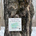
Hosting Club: Niagara Category: Loop Location (Google Maps): We will meet at the parking area located 380 meters north of the main trail crossing on Pretty River Rd.
Description We are going to visit the highest point of the Bruce Trail, which offers breathtaking views of the surrounding landscape and provides opportunities to spot diverse wildlife and bird species at Pretty River Provincial Park.
Because of elevation of Trail, “This hike is not recommended for beginners”.
Dress appropriately for the weather conditions. Make sure to wear hiking boots and bring hiking poles, bug repellent spray, snacks, lunch, and a minimum of 2 liters of water.
During the hike, we will take short water breaks, as well as a 30-minute lunch break.
Description Learn about using a two-eyed seeing approach to understanding and protecting nature, as you hike the Bruce Trail with Caley Doran, Indigenous Trail Guide and Layna Lubimiv, Chief Park Naturalist, MacGregor Point. During your hike, you will also participate in a communicty science project – picking up and sorting litter found along the trail and submitting litter data to the Bruce Trail Conservancy. Finish the hike by joining us for a group conservation about your experience and talk about what you have learned. This is a moderately paced hike covering rocky and rooty terrain with some short, steep climbs. Please bring water, light snacks, lunch. Wear sturdy footwear, hat and sun protective clothing. Bring sunscreen, insect repellent and garden gloves.
Parking Reservations are Required for all participants. Parking fees apply to non-residents of the Municipality of Northern Bruce Peninsula. Book early! 9:30-1:30 https://book.parkpassproject.com/book?inventoryGroup=1699994654&inventory=1592358846
Description Please join me at the south east corner of Sheppard Ave East and Leslie by 10 AM. We will hike south through several parks to Don Mills (S of Overleigh) (km 51.7 to km 62.4). Here is an online map with km markings of our route for all 7 hikes for the Toronto Urban Badge.
Please make sure you bring at least 2 liters of water, a lunch, bug spray and sunscreen.
Join us for this 3rd of four 2023 NBTC Nature Hikes to learn more about the biodiversity along the Niagara Escarpment. We will explore the trails throughout Louth Conservation area which offer beauty in all four seasons. Hikes will be held January, May, August & October – it will be amazing to see all the changes throughout the seasons. Your hike leaders, members of the NBTC Biodiversity Committee, will share their knowledge of the amazing flora & fauna along the trail as well as any biodiversity projects in the works for this year.
Be sure to register in advance as space is limited & the hike will be rescheduled in the event of heavy rains or heavy snow.
Contact Alicia Aitchison, aliciaaitchison1@gmail.com, with any questions.
Hosting Club: Sydenham Category: General Hike Location (Google Maps): The Owen Sound Galaxy Theatre parking lot. Meet at the tall “Galaxy Centre” sign next to the traffic lights.
Pace: Leisurely: 3 km/h or less Terrain: Easy: Mostly flat and good footing. Distance: 2.3 km
Description We will carpool to Lindenwood Rd. and do an easy hike of the Lindenwood loop. Map 33. For more information contact the hike leader at w.snel2@gmail.com or landline (519) 470-0584. If unable to register phone the hike leader.
Hosting Club: Caledon Hills Category: Tuesday Hikers Location (Google Maps): Meet at Hockley Road parking lot, north side of Hockley Rd. and east of 2nd Line EHS. DIRECTION: Go on Highway 410 north, this becomes Highway 10 north. After passing through Orangeville turn right on Hockley Road (7), shortly after passing 2nd Line EHS, BT parking lot is on the left.
Pace: Medium – 3 to 4 km/hour Terrain: Strenuous – hilly with steep climbs and some poor footing Distance: 12 km
Description Will hike parts of Hockley Valley trails; Glen Cross, Isabel East and Tom East connected by sections of main Bruce Trail. Bring 2 litres of water and snack. Hiking poles are strongly recommended, the distance may be shortened depending on weather conditions. Pace will vary due to hilly sections. Bring bug spray and sun protection. We just want to get out and enjoy the nature.
Hosting Club: Blue Mountains Category: Organized Hike Location (Google Maps):
Hike Leader(s): Terry Kimmerly
Pace: Medium – 3 to 4 km/hr Terrain: Moderate – Some hills and/or some poor footing
Description Beaver Springs Side Trail, Sydenham Forest East Side Trail, Pines Side Trail and Clearview Side Trail Hikers meet at trailhead at 8:30AM, (go to Irish Block Road in the Sydenham section at km 64.9) or you can meet in Collingwood behind Tim’s for 7:30am to carpool. The leader for the hike Terry Kimmerly (705-351-2494)
Pace: Medium Terrain: Moderate Length of Hike: 5.5kms
Description We will meet in the Metcalfe Rock parking lot and then arrange ourselves to shuttle to the Kolapore Parking lot. The hike starts by getting some road walking out of the way. Then it’s a varied walk past pasture/field/meadow, through cedar stands and under deciduous forest canopy to the base of Metcalfe Rock. Please bring water and a snack.
From Jordan Hollow Hike the main trail to Upper and Lower Balls Falls, Moyer Road or Louth and Return. You must register for each hike. Bring Poles, sunscreen, bug spray , snack and a drink and dress for the weather
Hosting Club: Caledon Hills Category: End-to-End Location (Google Maps): Meet at roadside parking at km 15.2 on Hurontario St. south of Hwy 89. Shuttle to start at BTC parking area on 1st Line E. Map 20.
Pace: Medium – 3 to 4 km/hour Terrain: Moderate – some hills and/or some poor footing, Strenuous – hilly with steep climbs and some poor footing Distance: From km 29.4 to 15.2, total distance 14.2 km. Map 20
Description This is the third hike of four. The trail takes us over bridges and a boardwalk, to lookouts with views of the Boyne Valley, across steep ravines, through old orchards and open fields, and to more bridges and boardwalks through the Boyne Valley Provincial Park. Map 20.
Description Join us for a Level 1 evening walk through Warden Woods and Taylor Creek Park. Expect a pace of about 3.5 km/hour. We will end at Don Mills and Overlea where three bus routes run to the Bloor/Danforth Line 2 subway.
Description Enjoy the benefits of pausing for a yoga practice as we tour through the trails, parkland and Historic Niagara-on-the-Lake. No mat required. Movement will focus on a flow of standing poses designed especially for hikers. Plan to stay for conversation and a warm cup of coffee or tea at Sweets & Swirls, Community Centre, Niagara Stone Road, NOTL.
Pace: Medium – 3 to 4 km/hr Terrain: Moderate – Some hills and/or some poor footing Distance: 15 km
Description
Starting at the Limehouse Parking Lot, the hike will follow the main trail, the Canada Goose Side Trail, the Ridge Side Trail and the Todd Bardes Meadowland Side Trail to form at 15 km loop. There will be regular breaks, including a lunch stop along the way. Bring snacks, a lunch and plenty of water. Please arrive at 9:15 am as we will depart promptly at 9:30 am. An optional pub stop may follow the hike.
Description This 2 hour hike is an introduction to the Bruce Trail. It is suitable for beginners of any age. The Bruce Trail in this location is a wheelchair accessible. You will be walking at a leisurely pace on flat, even terrain for a short distance. This is a great hike to meet new friends, learn more about hiking and the Bruce Trail! It’s fun!
The hike leaders will discuss:
how to prepare for a hike
safety considerations
how to find your way on the Bruce Trail
After the hike, we will have a picnic together, as we eat our lunch.
What to bring:
light backpack to carry your water bottles, cellphone and personal items
Lunch, blanket or lawn chair for the picnic
What to wear:
hat, sunscreen, layered clothing, sturdy walking shoes
Every participant will receive a “My First Hike Badge” from Bruce Trail Conservancy to celebrate your first hike on the Bruce Trail.
Pace: Moderate Terrain: Variable Distance: 14-15 KM
Description Will explore Toronto part of Rouge park along Rouge river and Little Rouge Creek,
Some safety procedures during the hike:
1-Hikers must stay between the leader and the sweep.
2-Hikers must advise the leader or the sweep if they wish to leave the group.
3- Hikers must follow the whistle instructions: 1 blast- stay where you are; 2 blasts come to the leader; 3 blasts – come to the leader quickly.
4-Hike leader may request volunteers to stop at trail intersections, they need to help hikers to the direction the group walk and wait till they see the sweep .
5-Hikers have to make sure they can see the persons behind and in front of them.
Pace: Medium – 3 to 4 km/hr Terrain: Moderate – Some hills and/or some poor footing Distance: 10.7km
Description Start time: 8:30AM Rock Spring-KOA Side Trail, Boyd Crevice, Palisades Side Trail, Merle Gunby Side Trail, East Linton Side Trail and Frank Holley Side Trail. 4 of 9 hikes. Hikers meet at trailhead at 8:30AM. Contact leader to confirm exact location of meeting.
Description We will hike along the main trail from Rush Cove to Jackson’s Cove and return via side trails – Cannon ST; Jackson’s Cove ST; Pease ST; Shoreline Access ST and Rush Cove ST.
Wear sturdy shoes and bring sunscreen, water and lunch. Expect to finish around 13:00, depending on the speed of the group.
Description We will hike south from East Gwillimbury GO Station to Fairy Lake and historic Main Street in Newmarket. We will pass the remains of a swing railway bridge, the remains of an abandoned canal, and a diverse landscape. The walking is easy south on this Level 1 Hike to Fairy Lake where we loop around the lake with a scenic boardwalk trail on the east side and paved path leading into the historic downtown of Newmarket. We’ll stop in the historic downtown for refreshments at the Old Flame Brewery or alternative establishments and walk up Main Street to get the 2:50 train back towards Toronto’s Union Station.
We will take advantage of the GO Transit $10 Day Weekend Pass available only on smartphones. Those without a smart phone may purchase the pass from the Hike Leader at Union Station the morning of the hike. Those wishing to travel together will meet at Union Station in the Great Hall by the information desk (with the clock over it) to take the GO Train towards Barrie departing at 8:53 AM.
Pace: Leisurely – 3km/hr or less Terrain: Moderate – Some hills and/or some poor footing Distance: 4-5 km
Description CANCELLED Due to changes in availability this hike has been cancelled. Join Logan Mercier, Conservation Halton, Landowner Outreach and Restoration Project Team member for a informative tour of the newly acquired and restored nature preserve formerly known at Kelso Quarry. More information is available at https://www.conservationhalton.ca/parks/area-8/ MINIMUM 5 participants for hike to proceed. We will meet at the parking lot and we are working on free parking for attendees. Donations to CH appreciated to support their many projects. If you have a Conservation Halton annual pass, please bring it. BTC members get discount on annual membership. As an education walk there will be a number of stops where Logan will explain the restoration process. There will be lots of opportunities for questions. Bring snack, water, personal first aid kit, sun protection and be prepared for biting insects including ticks. Note there are no facilities here. Hiking boots recommended. Bring binoculars if you have them. For more information please contact hike leader Bron brontreg@cogeco.ca In case you need to cancel the day of please text me with your name at 905-334-4013 Please arrive by 9:45 AM so I can check off your name and we can start the hike promptly at 10 AM. CANCELLED in inclement weather.
Hosting Club: Toronto Category: Car Hike Location (Google Maps): Km 65.8 Map 9. From Hwy 403 drive north on Hwy 6 for 1 km then exit at York Rd. Go west on York Rd. 1/2 km and turn right at Old Guelph Rd. After 1 km Old Guelph Rd makes a left turn and then a right turn. Turn right and follow 200m to parking at dead end. OR, from Clappison’s Corners (Hwy 5 & 6) drive south on Hwy 6 for 2 km to exit at York Rd. then turn right at Old Guelph Rd as described above. (Note: You want “York Rd” not “York Blvd” which is further south). My phone number is 905-301-4091. N 43.307417, W 70.911580
390-398 Old Guelph Rd, Pleasant View, Dundas, Ontario
Pace: Moderate Terrain: Hilly, Rocky Distance: 12 km
Description We will hike west on the Main Trail through the Rock Chapel and Borer’s Falls areas to the lookout at Sydenham Rd. Return by the same route.
Description Please join me at the south east corner of Overlea Blvd and Don Mills Rd by 10 AM. We will hike south on the Don Trail to the Distillery District (km 62.4 to km 71.4). Here is an online map with km markings of our route for all 7 hikes for the Toronto Urban Badge.
Please make sure you bring at least 2 liters of water, a lunch, bug spray and sunscreen.
Hosting Club: Sydenham Category: General Hike Location (Google Maps): The Owen Sound Galaxy Theatre parking lot. Meet at the tall “Galaxy Centre” sign next to the traffic lights.
Pace: Leisurely: 3 km/h or less Terrain: Moderate: Some hills and/or poor footing, There might be muddy sections. Distance: 7km
Description We will hike the main trail along Skinners Bluff with wonderful views along the escarpment, then take the Chris Walker side trail back to our cars – 3 km. Those that are up to it can then do do a further hike along the Slough of Despond side trail looping via The Presidents Path – 4 km. Map # 34 edition 30. If you are unable to register, please call or text the hike leader @ 416-848-8818.
Hosting Club: Caledon Hills Category: Tuesday Hikers Location (Google Maps): Meet in the Kinsmen Park parking lot – Frost Rd. Lincoln. Enter from Hixon St., at the intersection Of Kinsmen Rd. and Frost Rd. This is peach and wine country, time permitting we could visit a vineyard along the trail.
Pace: Medium – 3 to 4 km/hour Terrain: Moderate – some hills and/or some poor footing Distance: 12 km
Description Meet in the Kinsmen Park parking lot at 9:30 AM. From there we will shuttle to the Balls Falls Conservation Area. We will explore the park, the upper and lower waterfalls and then hike the main Bruce Trail back to Kinsmen Park parking lot. The trail runs mostly along the top of the escarpment with some ups and downs, through some meadows and fields, and past some interesting rock formations.
Bring water, lunch, snacks, poles if you like, sunscreen, bug spray, a hat.
Hosting Club: Blue Mountains Category: Register in person the morning of hike. Location (Google Maps): Hike meets in the parking lot behind Tim Hortons on First St. in Collingwood.
Pace: Brisk – 4 to 5 km/hr, Medium – 3 to 4 km/hr Terrain: Moderate – Some hills and/or some poor footing, Strenuous – Hilly with steep climbs and some poor footing Distance: 11.5km
Description We will drive to the Beaver Valley Ski Resort parking lot. The hike starts at the junction of the Beaver Valley Crossover Side Trail and the Kimberly Forest Side Trail. We will hike north on the Kimberly Forest Side Trail to the white blazed trail at km 83.1 then north to km 83.6 to do an in and out hike of the Wodehouse Karst Side Trail. We will then return south on the white blazed trail to the Valley Crossover Side Trail at km 79.5. From here it is all downhill to the Beaver Valley Ski Resort parking lot. Bring lunch and water.
Description 2023 is the 230th anniversary of the passing of the very first piece of anti-slavery legislation in the British Empire, which happened in Niagara-on-the-Lake (NOTL). We have a brave and determined Black woman named Chloe Cooley to thank. This guided hike offers an opportunity to learn about Chloe Cooley and her fight for freedom. It will celebrate the strength and perseverance of people of African heritage who lived in what was once the capital of Upper Canada. We will stop at numerous sites of historical significance. “Today let us remember the…freedom fighters of the past so that they may inspire future generations to build just societies.” unesco.org
This hike is in the open, so participants are reminded to come prepared for the sun and heat (e.g., sunscreen, hat and water).
Note: Niagara Black history hikes are offered by volunteers who have committed to their own learning, to be able to offer an informative and contemplative hike experience. These hikes are open to all and offered in a spirit of mutual learning and inclusion.
Location (Google Maps): Meet in the small parking lot of Duncan Crevice Caves Provincial Nature Reserve on the 9th Sideroad near Duncan. km 33.3, map 25, Edition 30
Pace: Medium Terrain: Moderate Length of Hike: 4.4 km
Description This hike takes us along a pleasant flat forest pathway to the impressive Duncan Crevices. There’s a walk along a field and then it’s on to the massive Pinnacle Rock. We then return to our original parking lot. Please bring water.
From Jordan Hollow Hike the main trail to Upper and Lower Balls Falls, Moyer Road or Louth and Return. You must register for each hike. Bring Poles, sunscreen, bug spray , snack and a drink and dress for the weather
Hosting Club: Caledon Hills Category: End-to-End Location (Google Maps): Meet at Mono Community Centre, southwest of km 1.2, on the gravel surface. Shuttle to start at km 15.2. Maps 20, 19.
Pace: Medium – 3 to 4 km/hour Terrain: Easy – mostly flat and usually good footing, Moderate – some hills and/or some poor footing Distance: From km 15.2 to 0.0, plus walk to parking area, total distance approx. 16 km.
Description This is the last of four hikes to complete the E2E. Following roads, through fields and woodlots then back on the road, the hike will take us to Mono Cliffs Provincial Park. Maps 20, 19.
Description Join us for an evening walk following the city of Toronto’s Garrison Creek “Discovery Walk” following the path of the buried creek to Fort York and then along the Harbourfront Waterfront Trail. The pace will be a moderate 3.5 km/hour.
Pace: Medium Terrain: Difficult, Easy, Moderate Distance: 14 Approx.
Description
This hike is through the mature forest of Hope Bay Forest Provincial Nature Reserve. We will hike the Hopeness, Jack Poste and Don Irish Side Trails and loop back on the main trail for some gorgeous lookouts overlooking the Hope Bay.
Dress according to weather. Bring water, lunch and wear appropriate footwear for rugged terrain.
Each Friday we will explore some history of Niagara-on-the-Lake while getting a moderate paced walk. Discover where the Niagara River meets Lake Ontario. Experience the Heritage District, woods and the Niagara Parkway.
Some weeks may be totally on sidewalks and roads while others may include a mix of trail and paved pathways.
Great way to build up endurance for longer more strenuous hikes.
Plan to stay for conversation and a coffee at Sweets & Swirls, Community Centre, Niagara Stone Rd., NOTL20
Hosting Club: Sydenham Category: Hike & Picnic Location (Google Maps): Parking area at Beautiful Joe Park in Meaford. From hwy 26, take Victoria Crescent south and keep right at the fork. The park entrance is on your right just before the bridge.
Pace: Medium: 3 to 4 km/h Terrain: Moderate: Some hills and/or poor footing Distance: 6 km
Description Meet at Beautiful Joe Park in Meaford at 9:15. We will walk along the shady river bank crossing some boardwalks, a few ups and down to the dam/mill ruin which will be our turn around point. Back at Beautiful Joe Park we will find a spot to have our own provided lunches (this is not a pot luck). On the hike good boots and poles are recommended, please bring water. If you are unable to register, call or text the hike leader at 705-888-1496.
Pace: Medium – 3 to 4 km/hr Terrain: Easy – Mostly flat and usually good footing Distance: 8 km
Description Please join Brooke Henry and Jackie Randle from the Bruce Trail Conservancy on a Rainbow/Pride Hike to celebrate the 2S-LGBTQ+ community ahead of Hamilton Pride. Whether you are part of the community or a supportive ally, we invite you to show your pride on the Trail by wearing rainbow colours. Be prepared for a moderate hike. We will hike at a medium pace with the planned distance being approximately 8 km.
All hikers will receive the Bruce Trail Conservancy Pride Badge as a thank-you for joining us.
Starting at Chedoke Golf Club, the hike will head up the Bruce Trail as it follows the Chedoke Radial Trail before entering the Iroquoia Heights Conservation Area and looping back via the Iroquoia Heights Side Trail.
Hikers are invited to join us after the hike at nearby Steeltown Cider for an optional drink to kick off the weekend.
Pace: Brisk – 4 to 5 km/hr, Medium – 3 to 4 km/hr Terrain: Strenuous – Hilly with steep climbs and some poor footing Distance: 38km
Description Please refer to the written description of the Spring/Summer/Fall Rim2Rim Badge on the BMBTC website. All three RIM hikes MUST be completed on the same day. The 3R2Rs in a DAY Challenge badge will be red, orange and yellow to reflect the level of difficulty. Currently, this hike badge is only available by registering on-line. You must have a vehicle to drive yourself to each RIM. You are encouraged to have a partner hiker with similar pace to complete the challenge as this will not be a traditional hike led by a leader, everyone’s pace differs. You MUST have a cell phone since there are no leaders/sweeps or drop out spots with volunteers. If you use the designated parking spots you will never be more than 6 kms away from your vehicle. You determine your rest stop frequency, and snack or meal needs as well as refreshments. You can decide what items to leave in the car (extra water and snacks) that don’t need to be carried for each “leg of the challenge”. You can plan to have lunch breaks at your car if desired. You must ensure you have plenty of water in your pack for each RIM. As this hike requires a significant amount of driving from one RIM to the next, we have included an outline below of the approximate time involved. Car travel times [according to Google Maps] from Bruce Trail Parking on 33/34 Sideroad [44.428118, -80.276849] to Devil’s Glen Provincial Park parking [44.36161, -80.20824] = 14 min for 14 km Car travel times [according to Google Maps] from Devil’s Glen Provincial Park parking [44.36161, -80.20824] to Noisy River Nature Preserve parking [44.27499, -80.20731] = 12 min for 15 km You and your partner should plan to set a pace between 4-6 km/hr ● Approximate time needed to finish about 40 km @ 6 km/hr = 6 hrs + 40 min + half an hour travel/resting/eating/drinking time = just over 7 hrs ● Approximate time needed to finish about 40 km @ 5 km/hr = 8 hrs + half an hour travel/resting/eating/drinking time = 8 and 1/2 hrs ● Approximate time needed to finish about 40 km @ 4 km/hr = 10 hrs + half an hour travel/resting/eating/drinking time = 10 and 1/2 hrs (The distance as measured by GPS is actually closer to 38km)
You are signing up for the following dates and times: 2023-08-26 at 07:30 2023-08-27 at 07:30 2023-09-02 at 07:30 2023-09-03 at 07:30 2023-09-04 at 07:30
Pace: Medium Terrain: Moderate, Some rocky footing, Some steep sections, Strenuous Length of Hike: The 5 hikes will range from approx. 22 km to 28 km. You set your own pace but medium will get the job done in timely fashion.
Description Please note that the event will be subject to current COVID protocols. It is recommended that hikers wear masks on the bus to help protect all of us from risk of contagion.
The registration fee of $100.00, members, $110.00 non members includes the online registration fee, transportation to the trail heads, refreshments and the End to End badge. There are no refunds for this event.
Further details of the event will be sent to participants once registration is received. Please arrive at 7:30 a.m. for check in and bus loading. The bus will leave promptly at 8:00 a.m.
COVID-19 Precautions Before and During the hike
Each hiker joining a Bruce Trail Club organized hike must perform a self-screening check before hiking. Find Ontario’s self-assessment tool here: https://covid-19.ontario.ca/self-assessment/
If you are experiencing COVID-19 symptoms, stay home.
Personal Protective Equipment:
Hikers may choose to wear masks on the trail and should wear masks on the bus.
We will explore Tommy Thompson park along Lake Ontario and listen to the birds and visit light house at the end of park.
Some safety procedures during the hike:
1-Hikers must stay between the leader and the sweep.
2-Hikers must advise the leader or the sweep if they wish to leave the group.
3- Hikers must follow the whistle instructions: 1 blast- stay where you are; 2 blasts come to the leader; 3 blasts – come to the leader quickly.
4-Hike leader may request volunteers to stop at trail intersections, they need to help hikers to the direction the group walk and wait till they see the sweep .
5-Hikers have to make sure they can see the persons behind and in front of them.
Pace: Moderate Terrain: Rocky, Variable Distance: 15 km
Description Join us to hike the Toronto section of the Bruce Trail in a series of four moderate pace/moderate distance Level 2 hikes (15-16 km a day). Those who complete all 4 hikes will qualify for the Toronto club’s diamond E2E badge. The badge fee ($5 members/$15 non-members) will be collected on Hike #3.
Members may alternatively choose to use the hikes to earn the new stained glass Limehouse stone bridge fundraiser badge. Available to members only the badge fee is $30 and proceeds go to protecting and preserving the Bruce Trail. Please contact the Hike Leader if you are interested in earning the fundraiser badge for further instructions. This badge can be earned only on one of the series of special group hikes led by a BTC Hike Leader and not individually.
Hikers who complete all 4 hikes will qualify for either the diamond badge or stained glass kfundraiser badge, as they have chosen.
Any hikers are welcome to join the hikes regardless of working towards one of E2E badges.
There will be a refreshment/social stop in Milton after the hike before returning to the Kipling Station departure point by 5:30 PM. Dropout at 11,3 km.
Note: This hike will not be visiting the falls at Hilton Falls Conservation Area (we take only the main Bruce Trail).
Description On this loop we will hike up hydro hill to connect with the main Bruce Trail and then connect with 12 Mile Creek and eventually return via the Twelve Side Trail.
Hosting Club: Blue Mountains Category: Register in person the morning of hike. Location (Google Maps): Hike meets in the parking lot behind Tim Hortons on First St. in Collingwood.
Pace: Leisurely – 3 km/hr. or less Terrain: Moderate – Some hills and/or some poor footing Distance: 5km
Description We will park at km 67.5 on the Lower Valley Road in the Beaver Valley section. We will hike on the Hoggs Falls Lower Side Trail, join up with the white blazed trail and continue north. Meeting up with the Hoggs Falls Upper Side Trail, we will hike west to form a loop back to the cars. The trail leads through forests, climbs out of the creek valley and follows along the edge of an open field before dropping down again onto an old logging road and into the beginning of a wide valley. Bring a snack or lunch and water.
Hosting Club: Toronto Category: Car Hike Location (Google Maps): We will meet at roadside parking at km 35.2 (Map 17 of the Bruce Trail Reference Guide, Edition 30) on the south side of Coolihans Sideroad where it intersects with Glen Haffy Road.
Description Celebrate the end of summer break with a trek, a token, and a treat!
First, we’ll do an out-and-back trek (approximately 4 km total) to explore “The Dingle”, which is a narrow-wooded valley in the Caledon Hills section of the Bruce Trail.
While on our hike, I will provide assistance to hikers of all ages who are interested in earning a token: the Caledon Hills Bruce Trail Club’s Nature Hunter Badge (http://caledonbrucetrail.ca/hiking/club-badges/nature-hunt-badge/)! I will point out and identify trees and wildflowers as we hike, as well as explain plant life cycles. This badge can be earned by children and adults alike, so this hike is for everyone! Please register all people who are planning on coming along on the hike.
Afterwards, we’ll make the short 5-minute drive to Daisy Cones (19258 Airport Road) in order to treat ourselves to some delicious Kawartha Dairy ice cream before we head home.
You should bring enough water and food for a 2-hour hike, comfortable hiking shoes, sun and bug protection, appropriate clothing for the weather, a camera if you want to earn the Nature Hunter Badge, and money if you intend to join us at Daisy Cones after the hike.
Description We will car pool to the start of the hike in Hillsburgh. The trail passes through mixed farmland and the village of Erin. The trail is mostly open with forest canopy in some locations. The trail is a former railway corridor and therefore flat. We can expect to make a brisk pace. Hiking boots are optional.
After the hike those so inclined may gather at a restaurant in Erin to replace electrolytes.
The meeting point for the hike is where the Elora Cataract Trail crosses Mississauga Road about 3.5 km north along Mississauga Road from Belfountain.
Hosting Club: Sydenham Category: General Hike Location (Google Maps): The Owen Sound Galaxy Theatre parking lot. Meet at the tall “Galaxy Centre” sign next to the traffic lights.
Pace: Medium: 3 to 4 km/h Terrain: Strenuous: Hilly with steep climbs and some poor footing., There might be muddy sections. Distance: 5 Km
Description Explore Rural Rocks and Obese side trails which are very rocky is some sections. We will be climbing over, under and between boulders. Good hiking shoes and sticks recommend as this will be rather rugged walking. Map #35 edition 30. If you are unable to register, please call or text the leader @416-848-8818.
Description Join us for a challenging adventure at Forks of the Credit Provincial Park. A section of the trail is rocky, with limited foot space, making it not recommended for beginners.
Dress appropriately for the weather conditions. Make sure to wear hiking boots and bring hiking poles, bug repellent spray, snacks, lunch, and a minimum of 2 liters of water.
During the hike, we will take short water breaks, as well as a 30-minute lunch break.
We will pass High Park and walk along Lake Shore Blvd. On the way, we will pass many small parks and Music Garden, and lastly arrive at Harborfront Centre to participate in the Taiwan Festival.
Pace: Leisurely: 3 km/h or less Terrain: Moderate: Some hills and/or poor footing Distance: 2.8 km
Description Carpool to Meaford Conc. 8 N. to hike the Clearview Side Trail loop. Map 31. For more information contact Bill Snel at w.snel2@gmail.com or landline at (519) 470-0584. If you are unable to register phone the hike leader.
Description Connect to the main trail from the parking lot and follow Louth side trail in a loop to rejoin main trail back to staff avenue. Stop and view louth falls.
You are signing up for the following dates and times: 2023-08-28 at 11:00 2023-09-11 at 11:00 2023-09-18 at 11:00 2023-09-25 at 11:00 2023-10-02 at 11:00
Hosting Club: Toronto Category: Car Hike Location (Google Maps): First hike will meet at 38.7 km parking area .Tenth Line and Walking Fern Side Trail. There will be a car shuffle to the end of the Toronto section and we will hike back to the cars. The following meeting points will be emailed to the registrants or arrange at the end of each hike.
Description A great way to start your week with a Monday morning hike. This will be a series of 5 hikes on the Toronto section to meet the requirements of the new and very pretty “Fundraisers End to End “badge. The hikes will be completed before Thanksgiving. We will not be hiking on Labour Day Monday. Check the posting for the dates The group will be small,the distance 8-11 km and the pace is leisurely. We are starting a bit later to miss the morning traffic,and will be done mid afternoon. There will be a car shuffle for each hike. When you register for this series of hikes you are registering for all five dates and you will need to pay for your badge. If you happen to miss a hike, a makeup hike can arranged.
Hosting Club: Caledon Hills Category: Tuesday Hikers Location (Google Maps): Sydenham Club , Woodford, Map 30 Parking is available in the Woodford Community Hall parking lot as well as on Woodford Cres.
Pace: Medium – 3 to 4 km/hour Terrain: Moderate – some hills and/or some poor footing Distance: 12 – 14 km depending on the number of side trails we include
Description Hiking the side trails and the Bruce Trail main trail; Silent Valley – acquired by the Bruce Trail Conservancy 10 years ago, the Valley has a story to tell “a fascinating story of geology, history, and disaster.” You can learn more about the unique history of this former farm in a book written by Ron Savage, (volunteer with the Bruce Trail) titled Silent Valley – A stunning jewel in a beautiful necklace.
MEET: 9:30 AM at the Woodford Community Centre Hwy 26 just east of Owen Sound.
From here we will shuttle to the parking area on 2nd Concession S. off Hwy 18. We will hike the Silent Valley Side Trail and loop through the additional side trails. There are several plaques of information on the property as well as artifacts, and an interesting landscape.
Following our exploration of the property we will hike the main trail back to Woodford. Along the way there are additional points of interest, including a look out over Bighead River Valley, a glacier spillway, caves and crevasses.
The trail can be wet in places, consider bringing extra foot wear. Bring water, beverages, lunch, snacks, poles optional, but terrain can be rough in spots. Sunscreen, bug spray, a hat suggested.
Hosting Club: Blue Mountains Category: Register in person the morning of hike. Location (Google Maps): Hike meets in the parking lot behind Tim Hortons on First St. in Collingwood.
Pace: Leisurely – 3 km/hr. or less Terrain: Moderate – Some hills and/or some poor footing Distance: 6km
Description Parking on the north end of 2nd Concession S in the Sydenham section, we will access the Silent Valley Side Trail and head towards the Wilson Homestead Side Trail. Afterwards, we will do a loop around Avalanche Pass Side Trail and investigate the Vanishing Wall Side Trail. We will visit the site of the Cessna 205 plane crash, look for the barn foundation stones, limestone kiln remains and many other treasures. You can even search for fossils! There will be some scrambling over rocks. Bring a snack or lunch and water.
Pace: Medium – 3 to 4 km/hr Terrain: Dependent on Conditions, Moderate – Some hills and/or some poor footing Distance: 12 km
Description We will hike through Hilton Falls Conservation Area on the Hilton Falls Side Trail and Conservation Area trails. Bring water and snacks. Wear clothing and footwear appropriate to weather conditions.
Park in Hilton Falls Conservation Area parking lot, accessible from Campbellville Road. Reservations are required. For further information see Conservation Halton web site: https://www.conservationhalton.ca/parks/hilton-falls/ Please arrive by 9:15 am as we will depart promptly at 9:30 am.
Location (Google Maps): Meet at the end of Fox Ridge Road where there is official parking, km 39.3, Map 25, Edition 30. We will take a couple vehicles to the start of our hike at Km 37.9 on Fox Ridge Road.
Pace: Medium Terrain: Moderate Length of Hike: 5 km
Description Our hike begins by walking through a hedgerow. Then we walk through a forested area and across some small streams. The Trail opens up to meadow with some views into the Valley. We’ll be experiencing land that was a fairly recent BTC land acquisition. On our return we will be walking along the pleasant Fox Ridge Road.
Hosting Club: Niagara Category: Night Location (Google Maps): Parking lot on north side of York Road just west of the Niagara River Parkway. Across the street from the Niagara River Recreational Trail. Look for the Greenbelt Route sign in the parking lot.
Description Once in a Blue Moon Night Hike – Park at the base of the escarpment (York Road just west of the Parkway) and follow the Niagara River Recreational Trail up to Queenston Heights to take in the magic of the rising moon over Niagara-on-the-Lake, follow the main trail to Alfred’s Trot side trail and loop back along the main trail. This hike includes a stop to connect with your senses – sights, sounds, smells and the rhythm of your breath. Counts towards your night hike badge (5 night hikes). Bring a night light and wear hiking shoes.
From Jordan Hollow Hike the main trail to Upper and Lower Balls Falls, Moyer Road or Louth and Return. You must register for each hike. Bring Poles, sunscreen, bug spray , snack and a drink and dress for the weather
Pace: Leisurely – 3km/hr or less Terrain: Moderate – Some hills and/or some poor footing Distance: Approx 10 km.
Description Scotsdale Farm is an area rich in the early history of farming and some quarrying. We will hike west from the farm on main trail towards Highway 7 and then hike the Duff Pit Side Trail, until we reach the Trafalgar Side Trail where we will connect to the main trail via the Great Esker Trail. We will turn south and west to return to the farm. We will be using a number of side trails today. Bring a snack, water, sunscreen and insect repellent. Poles may be useful. Leader: Anne Armstrong 905 617 3937 hikingrandma@gmail.com
Description In the midst of suburbia lies a quiet, forested valley.
Most of the route is flat, shaded, and on a packed gravel path. At 4.5 km we ascend one flight of stairs to the top of the valley (66 steps total). A short section in the north west – near 4th Line, immediately south of Dundas Street bridge – is signed as closed, but remains walkable.
This is a loop hike, and we will return to the parking lot where we meet up. Portable toilets are available at the start/end (Sixteen Hollow Park) and 3 km mark (Lions Valley Park).
Please pack one litre of water, a lunch or snacks, a hat and sun screen.