Description We will shuttle to km 0.0 and hike to km 16.1. We will enjoy the area of the Forks of the Credit and the Devil Pulpit. This hike can qualify for the winter badge as well as we will allow time for that badge. must have snowshoes and icers. Bring 2 litres of water. We will follow all Covid 19 rules. check before the hike in case the hike date is changes due to bad weather.
Description We will be car pooling, Bring Icers and poles. No dogs. To earn your Niagara Winter End to End badge, it must be completed between December 21, 2022 to March 21, 2023. Because of the potential for bad winter trail conditions we have broken this e2e into 6 hikes rather than 5
Hosting Club: Blue Mountains Category: Register on-line or sign-in morning of hike Location (Google Maps): Hike meets in the parking lot behind Tim Hortons on First St. in Collingwood.
Pace: Brisk – 4 to 5 km/hr, Medium – 3 to 4 km/hr Terrain: Moderate – Some hills and/or some poor footing, Strenuous – Hilly with steep climbs and some poor footing Distance: 12km
Description Please be prepared with icers’s or snowshoes.An enjoyable snowshoe along the white blazed trail through the upper escarpment, descending to the Standing Rock Side Trail where the trail becomes more challenging and quite the climb. An enjoyable view of Standing Rock in all its magnificence, then up and over icy rock faces and through icy cracks and crevices! Once at the top continue on to close the loop. Take the Franks Kiln Side Trail just before you reach the end of the loop to view a restored lime kiln that was originally built circa 1860. Bring a snack or lunch and water.
Pace: Medium – 3 to 4 km/hr Terrain: Easy – Mostly flat and usually good footing Distance: 8 km
Description This enjoyable walk by the Hamilton waterfront is from Bayfront Park parking lot to Princess Point, around a short loop at Princess Point and then back on a paved path. Sometimes we need a little encouragement to get out and enjoy the fresh air in the winter. Dress warmly as there may be winds.
Hosting Club: Sydenham Category: An evening walk. Location (Google Maps): Meet in the municipal parking lot by the river on the west side of 1st Ave. E between 7th St. E and 8th St. E in Owen Sound.
Pace: Brisk: 4 to 5 km/h Terrain: There might be icy and slippery sections. Distance: Approx 5 km
Description This hike WILL leave at 7:00 pm – no need to arrive early. This evening we will explore trails and neighbourhoods in Owen Sound. Please bring icers if conditions are icy. For further information contact Harriet Nixon at 519-373-6598 or harrietnixon@bmts.com
From Jordan Hollow Hike the main trail to Upper and Lower Balls Falls, Moyer Road or Louth and Return. You must register for each hike. Bring Poles, snack and a drink ices and dress for the weather
Hosting Club: Sydenham Category: Snowshoe Hike Location (Google Maps): Parking area at south end of 11th Concession by the rail trail, north of km 86.5 (Map 32)
Pace: Medium: 3 to 4 km/h Terrain: Strenuous: Hilly with steep climbs and some poor footing., There are crevices or holes which may be hidden by layers of snow. Hike with extreme caution.
Description This will be an in and out hike. We will follow the rail trail to the main trail. We will walk through cedar forests which lead to giant dolostone blocks separated by spectacular crevices. We may need to remove our snowshoes as we explore the area. We will then head back to our vehicles.
Pace: Leisurely – 3km/hr or less Terrain: Moderate – Some hills and/or some poor footing Distance: 10 – 11 km. depending on route selected
Description Today’s hike will take us from City View Park to Smokey Hollow and back. Depending on conditions we many include the McNally and Norman Pearson Side Trails which include a long climb up Grindstone Creek to Smokey Hollow. Meet at 9:45 am. for a 10:00 am. start in the first parking lot on your right in the most southerly parking lot of City View Park (not the one with the soccer fields and baseball diamond on Kerns Rd.) Bring water, a snack, icers and poles if using. If cancelling after 8:00 am. on the day before the hike please email leaders or text. Leaders: Anne and Phill Armstrong 905 617 3937 hikingrandma@gmail.com
Pace: Medium Terrain: Moderate, Some steep sections Length of Hike: 5 km
Description Enjoy a part of the Beaver Valley that rarely has crowds. We will take the Main Trail to the Stew Hilt’s Side Trail. There is a wonderful view of a (frozen) waterfall. Once we join up with the Main Trail again, we’ll continue for a distance to enjoy cross-the-Valley views. We’ll then return on that section of Main Trail and continue on the Main Trail back to the parking area. Making the hike a loop “with a leg”.
Please be prepared to wear snowshoes or icers, depending on the conditions at the time of the hike. Bring water and a snack.
COVID-19 Precautions Before, During and After your Hike
Each hiker joining a Bruce Trail Club organized hike must perform a self-screening check before hiking. Find Ontario’s self-assessment tool here: https://covid-19.ontario.ca/self-assessment/
If you are experiencing COVID-19 symptoms, stay home.
Personal Protective Equipment:
Hikers may choose to wear masks
Transportation
It is the Bruce Trail Conservancy’s current policy that car shuttles are allowed. It is at the discrepancy of individual hike leaders to make that decision.
Other Guidelines
Arrive 15 minutes before the start of the hike.
Wear sturdy footwear and appropriate attire for the weather and the terrain. Hiking poles are a good idea in any season, especially if the terrain is rocky or slippery. In winter, snowshoes or icers/crampons are needed when conditions dictate. Wearing appropriate clothing and footwear prevents injuries and shows consideration for a safe and positive group hiking experience.
Always carry I.D. and your health card.
Bring sufficient water and snacks (or lunch if indicated). A minimum of 1L of water is recommended on all hikes, and 3L is recommended for long, challenging hikes in the heat of the summer.
Bring sunscreen and insect repellent (for spring and summer hikes).
Description Black History Hike #1 – An Introduction to Black Slavery in Upper Canada
Since 1995, the government of Canada officially recognized February as Black History Month; a time when Canadians are invited to reflect, educate and engage in the ongoing fight against anti-Black racism and discrimination. This series of four hikes will give us an opportunity to celebrate the strength and perseverance of the early Black community here in Upper Canada.
Wear extra warm clothing as we will be stopping several times. While the terrain is easy, consider bringing your walking sticks and/or footwear with micro spikes. Sidewalks and streets may be icy.
Description Since 1995, the government in Canada officially recognized February as Black History Month; a time when Canadians are invited to reflect, educate and engage in the ongoing fight against anti-Black racism and discrimination. During this and the other hikes in this series, you will learn about some of those who fought enslavement, and how they were pivotal in shaping our society to be as diverse as it is today.
Wear extra warm clothing as we will be stopping several times. While the terrain is easy, consider bringing your walking sticks and/or footwear with micro spikes. Sidewalks and streets may be icy.
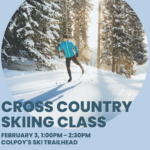
Location (Google Maps): Colpoys Ski Trailhead. The Trailhead is located just north of Colpoys Bay on Bruce County Road 9 (44.785044° -81.124368°). Parking is available here.
Description Join us for an afternoon on the Bruce Trail at Colpoys Bay Ski Trail. Learn, or refresh your cross-country ski skills and techniques from a Bruce Trail Ski Club instructor. Don’t have skis? Consider renting equipment from nearby Suntrail Source for Adventure in Hepworth. PBTC and SBTC members only. FREE! (does not include ski rental) Registration required. Parking is available at the Colpoy’s Ski Trailhead (GPS co-ordinates – 44.783246, -81.124349) just north of the village of Colpoy’s Bay on the east side of County Road 9 – Bruce Trail Map 35.
Description Bus departs from 10 York Mills Rd at 8 AM. Please arrive 15 minutes before departure. The bus waits for no one.
Join us for a fantastic day of cross-country skiing and snowshoeing at Kawartha Nordic on the beautiful Canadian Shield. Bring some seeds and feed the chickadees. Snowshoers: Join George and Michael for a fun-filled guided snowshoe hike, or team up with some friends and explore the trails at your own pace. Skiers: Explore the forest on 46 km of trails groomed for classic and skate skiing. Keep your eyes peeled for deer. Classic ski and skate ski rentals available. Limited snowshoe rentals available so best to bring your own. If renting equipment, complete the rental form and bring it with you to the rental shop.
Coach fares must be paid online when you register. Trail fees will be collected in cash on the bus (please bring exact change; quarters, dimes and nickels will not be accepted). Masks are mandatory while on the bus.
Hosting Club: Toronto Category: Car Hike Location (Google Maps): Parking lot before the main gate of Boyd conservation park Islington Avenue,
Hike Leader(s): Mohammad Aghamiri
Pace: Moderate Terrain: Variable
Description Explore the trails that wind through the beautiful valley at Boyd Conservation Area and the William Grainger Greenway. We will have lunch/snack in shelter with seated area,
It is winter time all participants are required to have Ice cleats with them, have proper shoes, warm clothing and hot drinks with you.
Please carefully read safety procedures during the hike:
1-Hikers must stay between the leader and the sweep.
2-Hikers must advise the leader or the sweep if they wish to leave the group.
3- Hikers must follow the whistle instructions: 1 blast- stay where you are; 2 blasts come to the leader; 3 blasts – come to the leader quickly.
4-Hike leader may request volunteers to stop at trail intersections, they need to help hikers to the direction the group walk and wait till they see the sweep .
5-Hikers have to make sure they can see the persons behind and in front of them.
Hosting Club: Caledon Hills Category: General Location (Google Maps): Meet at the BTC parking lot on the east side of 5th Line EHS, just south of Hockley Road. 43.993572, -80.014057 (Map 18, Edition 30)
Directions: From ON-10 turn east onto Hockley Rd/Dufferin County Rd 7. Drive for 9.4 kilometres. Turn south/right onto 5 Line E. Drive for 100 metres.
Pace: Medium – 3 to 4 km/hour Terrain: Strenuous – hilly with steep climbs and some poor footing Distance: 9.5 kilometres
Description
Beat the winter blues! Register individually for one, a few, or all of our Frosty Five Winter Blues Weekend Badge hikes. Participants who complete all five hikes will be eligible to receive a CHBTC Winter badge and a Sideways badge on the final hike. Hike three explores parts of the main Trail and Hemlock Ridge, Griffith Ravine and Glacier Valley Side Trails in the south Hockley Valley area. Bring your choice of hydration and snacks. Hiking boots and icers/crampons are required. See January 7, January 21, February 18, and March 4 for details pertaining to the other hikes in the series. (Note: If you wish to purchase badges, the cost of each badge is $10.00 for BTC members and $15.00 for non-members.)
We will be car pooling, Bring Icers and poles. No dogs. To earn your Niagara Winter End to End badge, it must be completed between December 21, 2022 to March 21, 2023. Because of the potential for bad winter trail conditions we have broken this e2e into 6 hikes rather than 5
Pace: Medium – 3 to 4 km/hr Terrain: Moderate – Some hills and/or some poor footing Distance: 7km
Description Due to lack of registration there will be no morning sign-in. This hike has been cancelled.
Please be prepared with icers’s or snowshoes.We will drive to Kilgorie in the Dufferin Hi-Land section and park the cars at km 34.9 on Centre Road. From here, we will hike a figure 8 loop utilizing the white blazed trail, the new Pine River Valley Side Trail, and the Kilgorie Side Trail. This hike boasts a wonderful view from the Bell Tower Side Trail, ruins of an old powerhouse, the stunning Pine River, lake views, ponds, and more! The ruins of the old powerhouse along the Pine River are almost all that remain of the Dufferin Light and Power Company. Nearby is the old flume that brought water from a dam which, when constructed in 1909, was the largest of its kind in Ontario. The plant provided power until 1923. Bring a snack or lunch and water. Map: 20 Edition 30
Hosting Club: Iroquoia Category: General Hike Location (Google Maps): Trail begins on Miller Drive, Georgetown. Closest address is 124 Miller Drive. Plenty of parking on the road.
Pace: Medium – 3 to 4 km/hr Terrain: Easy – Mostly flat and usually good footing Distance: 5 km
Description
Join me for a Guided Meditation Hike through Hungry Hollow Georgetown. It will be 5km at a slow to moderate pace on well groomed trails. The trails wind through the Hungry Hollow Ravine along Silver Creek. The trail is nestled in Georgetown and known for its beautiful nature, marshes, meadows, and ponds, with boardwalks, and bridges.
Meet at 9:45am Sharp to get ready and hike in at 10:00am.
Duration: 2 hours
Also a great hike for those that would like to start hiking and looking for an introduction to how to hike.
Please bring your phone with a full battery and earbuds to listen to the meditation. Download Spotify. The meditation will be for 1/2 hour with plenty of time to meet and chat with the other hikers for the duration of our hike together.
Please wear hiking boots, icers, backpack with water and snacks. Hiking poles are great for balance but optional..
Hosting Club: Toronto Category: Urban Walk Location (Google Maps): NE Corner Yonge & Lawrence (by subway exit)
Hike Leader(s): Tom Swales
Pace: Moderate Terrain: Variable Distance: 12 KM
Description Join us for a hike through ravines from Yonge & Lawrence to Sunnybrook & Serena Gundy parks to end at Brentcliffe & Eglinton. Those who wish may continue to a refreshment stop at Cork’s Beer & Wine Bar in the Longo’s grocery store on Laird Ave. All are welcome but proper ice traction footwear (icers) is mandatory for safety reasons.
Please join me at Bathurst Station no later than 9:00 am. We will take the streetcar southbound departing 9:38 am, arriving at Adelaide St 9:54 am. If you want to meet us at Bathurst and Adelaide, be there by 9:54 am. We start hiking at 10:00 am.
We will hike to the lake and east to Leslie St. The estimated distance is 9.4 km. Here is an online map of our route Bathurst to Leslie
Bring a snack, at least 2 liters of water, and icers. Dress for cold weather.
Location (Google Maps): Meet on the south shoulder at the end of North St. in Eugenia. (North Street is just north of the Top O’ The Rock store) Turn to park cars facing east. km 58.3, Map 26, Edition 30
Pace: Medium Terrain: Moderate, Some steep sections Length of Hike: Approx. 6 km
Description This is the first hike of two to earn the Snowshoe Adventure badge. The hike will proceed without snowshoes if they’re not needed. Please do bring snowshoes and icers. We’ll be hiking along the escarpment through forest to the Beaver Valley landmark “The Penstocks” and then returning to our cars. Some great views to be had! If the night is clear and the moon is out, headlamps aren’t necessary and the tree shadows on the snow are beautiful.
COVID-19 Precautions Before, During and After your Hike
Each hiker joining a Bruce Trail Club organized hike must perform a self-screening check before hiking. Find Ontario’s self-assessment tool here: https://covid-19.ontario.ca/self-assessment/
If you are experiencing COVID-19 symptoms, stay home.
Personal Protective Equipment:
Hikers may choose to wear masks
Transportation
It is the Bruce Trail Conservancy’s current policy that car shuttles are allowed. It is at the discrepancy of individual hike leaders to make that decision.
Other Guidelines
Arrive 15 minutes before the start of the hike.
Wear sturdy footwear and appropriate attire for the weather and the terrain. Hiking poles are a good idea in any season, especially if the terrain is rocky or slippery. In winter, snowshoes or icers/crampons are needed when conditions dictate. Wearing appropriate clothing and footwear prevents injuries and shows consideration for a safe and positive group hiking experience.
Always carry I.D. and your health card.
Bring sufficient water and snacks (or lunch if indicated). A minimum of 1L of water is recommended on all hikes, and 3L is recommended for long, challenging hikes in the heat of the summer.
Bring sunscreen and insect repellent (for spring and summer hikes).
Hosting Club: Dufferin Hi-Land Category: General Hike Location (Google Maps): Dufferin Hi-Land, Map 19. Mono Cliffs Provincial Park. Meet at south end of 1st Line EHS, Mono (Km 7.9), south of 25 Sideroad. Directions ; Coming north on Hwy 10 turn right on 25 Sideroad ( approx. 14 km north of Orangeville ) then right on 1st Line EHS follow to end. NOTE Parking is very limited if you can car pool with someone that would be a great help BE CAREFUL OF THE DITCHES!
Description Meet 6:15 pm for a 6:30 pm start Be on time no waiting ” IT’S COLD ” We will do a 8 km hike in Mono cliffs Prov. Park. Bring Water, Snack, Headlamp. Snowshoes are essential. Dress for the conditions.
Hosting Club: Toronto Category: Car Hike Location (Google Maps): We will meet at km 18.7. Coordinates N 44.117420,W 80.128361. A 100 meters trail leads to the main trail.
Pace: Brisk Terrain: Hilly, Variable Distance: 18.7 km
Description First hike of three to complete the Dufferin section end to end. This is a winter hike. Could be hiking in deep snow. Make sure to bring snowshoes and icers. Dress in layers. Bring 2 litres of water. We will follow the covid 19 instructions. We will shuttle to km 0.0. Please note that we will park in Mono centre. It is a paid parking. We will all share the parking cost.
Description We will follow the Etobicoke Creek South, hoping to finish around Brampton city hall. Please arrive at least 15-20 minutes prior to the start time.
Pace: Medium – 3 to 4 km/hr Terrain: Moderate – Some hills and/or some poor footing, Slippery Sections Likely, Strenuous – Hilly with steep climbs and some poor footing Distance: 17 km.
Description Join us for a winter wonderland shuttle hike on rocky terrain with some great views from the heights of the escarpment. We will take in the Main Trail and the Charles Hildebrand and Philip Gosling Side Trails. Please bring icers, a snack, a lunch, water, a warm drink, and an appreciation of nature and good people. Conservation Halton reservations required at Hilton Falls CA. We will not be taking in the Falls on this hike but we will be seeing a smaller waterfall on the trail. Possible optional pub stop after.
Pace: Medium – 3 to 4 km/hr Terrain: Dependent on Conditions, Moderate – Some hills and/or some poor footing Distance: 12 km
Description We will hike through Hilton Falls Conservation Area on the Hilton Falls Side Trail and Conservation Area trails. Bring water and snacks. Wear clothing and footwear appropriate to weather conditions. Icers and/or snowshoes may be required, depending on conditions.
Park in Hilton Falls Conservation Area parking lot, accessible from Campbellville Road. Reservations are required. For further information see Conservation Halton web site: https://www.conservationhalton.ca/parks/hilton-falls/ Please arrive by 9:15 am as we will depart promptly at 9:30 am.
An optional pub stop will take place following the hike – details all be provided a few days prior to the hike.
Please join me at Old Mill Station no later than 9:12 am. We will take the 66 bus departing 9:27 am, arriving 9:40 am. If you want to meet us at Parklawn and Lakeshore, please be there by 9:40 am. We start hiking at 9:50 am.
We will hike east along the lake to Spadina. The estimated distance is 9.1 km. Here is an online map of our route Parklawn to Spadina
Bring a snack, at least 2 liters of water, and icers. Dress for cold weather.
Hosting Club: Sydenham Category: Snowshoe Hike Location (Google Maps): Parking lot at Harrison Park, Owen Sound, in front of the Harrison Park Inn, north of km 96.7 (Map 32)
Pace: Medium: 3 to 4 km/h Terrain: Moderate: Some hills and/or poor footing, There might be icy and slippery sections. Distance: 5 kms
Description This hike takes us along the main trail to the Palisades Side Trail. We meet up with the Harrison Park Side Trail to return to the parking lot. Depending upon the conditions, snowshoes or icers will be needed. The Palisades area can be challenging but we will take it slowly. Hiking poles are recommended. Approximately 2 to 2 1/2 hours. Refreshments afterwards at the Harrison Park Inn. If you are unable to register, please call or text Maureen at 647-918-4180.
Hosting Club: Toronto Category: Car Hike Location (Google Maps): Km 18.7 coordinates N 44.117420,W 80.128361 centre street south of the 5 Sideroad. A. 100 meters south of the main trail.
Pace: Brisk Terrain: Hilly, Variable Distance: 19 km
Description We will shuttle to km 37.7 and hike to the cars. Bring snowshoes and icers, 2 litres of water. We will follow all Covid 19 instructions. Please note that there may be a need to change the date due to winter conditions.
We will meet at Jordan Hollow Park, King St (Hwy 81) across from Boo’s Restaurant 3039 King St, Jordan Station After completing the Ball’s Falls hike, we will drive to Jordan Main Street Parking Lot beside RPM Bakehouse ( 43.1492718 -79.3696930) and complete the walking tour of the town. Hikers have the option to do the next hike from Mountainview Conservation (43.157888 -79.498415) independently or with the leader on the same day.
Pace: Medium Terrain: Moderate Distance: 9-15 km dependent on doing 3rd hike from Mountainview Conservation Area the same day
Description This series of 3 hikes is a joint effort of NBTC and the Lincoln Museum to introduce hikers to the Niagara Benchlands area. We will complete the Ball’s Falls hike first, then move to the town of Jordan and explore the historical homes in town as well as the Museum if it is open.
Please refer to the following site for badge requirements: http://niagarabrucetrail.club/wp/wp-content/uploads/2022/12/Niagara-Benchlands-Badge.pdf
It is also recommended to download the following pdf: https://qrco.de/bch3Qi and print the map on page 10 of the PDF
After these 2 sections are completed, hikers will have the option to 1) continue to Mountainview Conservation to complete the third hike with the hike leader or 2) complete this hike independently when convenient. If #2 is the choice, then hikers will need to submit the required information independently to receive the badge.
If completing all 3 hikes, then badges will be available after the third hike. Members $10, Non members $15
Hosting Club: Caledon Hills Category: Tuesday Hikers Location (Google Maps): Parking at: 10 Side Road and 4th Line Nassagaweya (trail entrance to Halton Regional Forest). From Highway 401 West, turn right (north) on Guelph Line, right on 10 Side Rd. it will bend northwards and become 4th Line Nassagaweya; park at the bend, roadside.
Pace: Medium – 3 to 4 km/hour Terrain: Moderate – some hills and/or some poor footing Distance: 13 km
Description Will hike trails in Halton Regional Forest, Hilton Falls Conservation Area and a beautiful section of the blue trail overlooking Beaver Dam. Trails are relatively flat with some rocky parts. Snack break at Hilton Falls. Bring water, snack and a warm drink. Dress according to weather in layers, icers are required, poles recommended. Hike leader cell phone: 416-566-0503 (note that reception in hiking area is usually poor, leave messages to callback). Check your email at 7:30 am, on the hike day, a message will be sent if there is change due to adverse weather or driving conditions .
Location (Google Maps): Beaver Valley section, km 85. Please meet at parking on 7A. Please access 7A from 7th Line (NOT GREY ROAD 7) sorry about all the 7’s Map 26-ED 30
Pace: Brisk Terrain: Moderate, Some steep sections Length of Hike: 7km-10km depending on conditions (2.5-3 hrs)
Description This in and out hike will take us from km 85 southbound to Kimberley Forest side Trail. Once we reach the end of Kimberley Forest we will re-trace our steps northbound. If time and terrain allow we will take a quick in and out of Wodehouse Karst Side Trail before returning back to our cars.
Please be prepared with icers and snowshoes
Bring water and a snack
Please no dogs
Text Kristina @ 519-410-9077 for morning of cancelations
Hosting Club: Dufferin Hi-Land Category: Tuesday Hike Location (Google Maps): For car pooling, meet at parking on the east side of Party City/Winners building in Orangeville, Hwy 10 and 4th Ave. at 8:30 am. Or meet at Cold Creek Conservation Area on 11th Concession, King, 3.5 km north of King Rd. Park in front of entrance gate for 9:30 am start.
Pace: Medium Terrain: Easy, Slippery Sections Likely Distance: Long hike 6.6 km Short hike 2.5km or 4 km
Description We will hike the outer loop, experiencing various types of ecosystems– forests, meadows, wetlands and pine plantations. The shorter hike will return to the parking lot by way of one of the connector trails–North Connector 2.5 km or South Connector 4 km. Bring snacks and water. Icers are recommended. If the snow is deep , snowshoes may be needed.
Hosting Club: Toronto Category: Car Hike Location (Google Maps): Meet at the (roadside) parking area at the end of 17 Sideroad, 730 m northeast of Halton Rd 25. Map 12.
Pace: Leisurely Terrain: Variable Distance: approximately 2 k
Description
Join us for a slow walk in the woods to observe and identify the impressive variety of trees in this area, without the benefit of examining their leaves! The distinctions found in twigs, buds and bark are just some of the clues we will be seeking, with the assistance of our guide, Adam Brylowski, an ecologist on staff at the BTC.
Please dress for the weather, and along with your curiosity, I suggest a hot drink, water and lunch or snack. End time and distance we’ll travel are estimates, depending on weather snd trail conditions.
This hike is brought to you by the TBTC’s Biodiversity Team. We endeavour to promote the critical role we can all play in protecting and conserving the Niagara Escarpment.
Pace: Brisk Terrain: Challenging, Hilly Distance: 17 km.
Description We will shuttle to km 52 and walk back, some challenging hills. Bring snowshoes and icers. Bring 2 litres of water. This hike will also be used for the winter badge as we will make the time for it. Make sure to check your email before the hike for a change of date because of bad weather. We will follow covid 19 rules.
Description We will be car pooling, Bring Icers and poles. No dogs. To earn your Niagara Winter End to End badge, it must be completed between December 21, 2022 to March 21, 2023. Because of the potential for bad winter trail conditions we have broken this e2e into 6 hikes rather than 5
If you have completed all 6 hikes bring $10 for the coveted Winter End to End Badge
Hosting Club: Blue Mountains Category: Register on-line or sign-in morning of hike Location (Google Maps): Hike meets in the parking lot behind Tim Hortons on First St. in Collingwood.
Pace: Medium – 3 to 4 km/hr Terrain: Moderate – Some hills and/or some poor footing Distance: 8km
Description Please be prepared with icers’s or snowshoes.We will park at Lavender Cemetery roadside parking about 0.5 km east of Lavender Hill Rd on Mulmur-Nottawasaga TownLine. We will hike from the cemetery (1km) over to the start of the Blue Mountains section. We will snowshoe for approximately 3km and then turn around heading back to the cars. This hike offers a variety of terrain, along crevices, through forest, fields. Bring snacks and adequate water.
Hosting Club: Iroquoia Category: Good Companions Location (Google Maps): 101 Osler Dr in Dundas, behind the Shoppers Drug Mart, in the parking area adjacent to the trailhead
Pace: Medium – 3 to 4 km/hr Terrain: Easy – Mostly flat and usually good footing Distance: 9 km
Description This leisurely hike is on a wide path, mostly flat but with a slight ascent to the train station. We will stop at the station for a break and snack before heading back. Please arrive at 9:45 in the parking lot for a 10:00 sharp start. Dress warmly and wear good footwear in case there is some ice on the path. Sometimes we need encouragement to get out in the winter, so join in this social walk. The hike will be cancelled if the weather is poor weather.
From Jordan Hollow Hike the main trail to Upper and Lower Balls Falls, Moyer Road or Louth and Return. You must register for each hike. Bring Poles, snack and a drink ices and dress for the weather
Pace: Leisurely – 3km/hr or less Terrain: Dependent on Conditions, Moderate – Some hills and/or some poor footing Distance: 10 – 14 km.
Description Scotsdale Farm and its surrounding trails make for an interesting hike with varied terrain. Our hike today takes us west to the Duff Pit Side Trail, then east along the new Trafalgar Side Trail entering the Great Esker Side Trail. Here there will be a choice of continuing east to pick up the Bennett Side Trail (longer version) or returning west via the main trail to the parking lot (shorter version). Meet at 9:45 am. for a 10:00 am. start in the main parking lot of the farm. Bring water, a snack or lunch, icers and poles if using. If cancelling after 4:00 pm. the day before please text or email leader. Leader: Phill Armstrong 416 895 3937 hikingrandpa@gmail.com
Description We will shuttle to km 16.1 and hike back. The hike includes road walking. Be ready for cold winds on the road sections. This hike will qualify for the winter badge. We will allow time for that badge. Must have icers and snowshoes. Bring 2 litres of water. We will follow covid 19 rules. Check for change of date before the hike in case of bad weather.
Description Black History Hike #2 – Richard Pierpoint and the Coloured Corps.
Since 1995, the government of Canada officially recognized February as Black History Month; a time when Canadians are invited to reflect, educate and engage in the ongoing fight against anti-Black racism and discrimination. This series of four hikes will give us an opportunity to celebrate the strength and perseverance of the early Black community here in Upper Canada.
Wear extra warm clothing as we will be stopping several times. While the terrain is easy, consider bringing your walking sticks and/or footwear with micro spikes. Sidewalks and streets may be icy.
Description Since 1995, the government in Canada officially recognized February as Black History Month; a time when Canadians are invited to reflect, educate and engage in the ongoing fight against anti-Black racism and discrimination. You will find out about some of those who fought enslavement, and how they were pivotal in shaping our society to be as diverse as it is today.
Wear extra warm clothing as we will be stopping several times. While the terrain is easy, consider bringing your walking sticks and/or footwear with micro spikes. Sidewalks and streets may be icy.
Description Trip cancelled due to weather and too many cancellations.
Bus departs 10 York Mills Rd at 8:00 AM and Major Mackenzie Dr and HWY 400 Park and Ride at 8:20 AM. If you wish to be picked up at the Major Mackenzie Dr and HWY 400 Park and Ride, select that option when you register. Please arrive 15 minutes before departure. The bus waits for no one.
Join us for an awesome day of cross-country skiing and snowshoeing in beautiful Awenda Provincial Park. For information about trail conditions visit: https://www.ontarioparks.com/skireport. Snowshoers: Explore the trails on your own or join Nijole and Tanya for a guided 10 KM snowshoe hike on Awenda’s beautiful winter trails. The hike will traverse parts of the Bluff, Wendat, and Connector trails, and will also circle around Kettle’s Lake. Mostly flat with a few short hills. Pace will be approximately 3 km/hr. Plenty of time to take pictures and enjoy the scenery. Skiers: Enjoy self-guided tours of Awenda’s beautiful ski trails with majestic views of Georgian Bay. No rentals.
Coach fares and park admission must be paid online when you register. Masks are mandatory while on the bus.
We will be car pooling, Bring Icers and poles. No dogs. To earn your Niagara Winter End to End badge, it must be completed between December 21, 2022 to March 21, 2023. Because of the potential for bad winter trail conditions we have broken this e2e into 6 hikes rather than 5
Hosting Club: Niagara Category: Loop Location (Google Maps): Meet in the upper parking lot of Fireman’s Park, Dorchester Rd and Mountain Rd, Niagara Falls
Description Winter hiking at its best! Hike around Fireman’s Park on the Bruce Trail and other recreational trails. Poles and icers recommended. Bring water and a snack.
Hosting Club: Toronto Category: Urban Walk Location (Google Maps): Union Station – Meet in the Great Hall by the information desk with the clock over it by 9:00. We will take the 9:13 Stouffville Line train to Mount Joy GO Station and connect to the GO Bus towards Uxbridge. You may alternatively board the GO Train at Kennedy GO Station or stops in north Scarborough. The GO $10.00 Transit Day Pass, available for smart phones, is valid for return travel on the train and GO Bus. Hikers without a smart phone may purchase the Day Pass from the Hike Leader. Seniors return fare from Union is $11.06.
Hike Leader(s): Tom Swales
Pace: Moderate Terrain: Variable Distance: 12
Description Join us for a winter hike on the Countryside Preserve trails, the Ewan and Historic Trails into downtown Uxbridge, and the Trans Canada Trail over the trestle bridge. We’ll also pass by the historic train station and railway museum. Due to the limited bus service plan on joining us for a refreshment stop before returning to the city. Bring icers (mandatory) and poles if preferred. The trails are well used so walking should be fairly easy unless there is a lot of fresh snow.
Hosting Club: Iroquoia Category: General Hike Location (Google Maps): Rattlesnake Point Conservation Area Parking Lot (Appleby Line 1km north of Derry Road.
Pace: Medium – 3 to 4 km/hr Terrain: Dependent on Conditions, Moderate – Some hills and/or some poor footing Distance: 11 km
Description We will hike on the Conservation Trails, the Rattlesnake Point Side Trail, main Bruce Trail, and Crawford Lake Side Trail to Crawford Lake and back. Wear appropriate clothing and footwear for weather conditions. Icers and/or snowshoes may be required depending on conditions.
Hosting Club: Blue Mountains Category: Register on-line or sign-in morning of hike Location (Google Maps): Hike meets in the parking lot behind Tim Hortons on First St. in Collingwood.
Pace: Leisurely – 3 km/hr. or less Terrain: Easy – Mostly flat and usually good footing Distance: 6km
Description Please be prepared with icers’s or snowshoes.We will park the cars on Conc. 10 South, north of Cty Rd. 124. We will begin hiking at km 34.2 heading south to km 31.7. The trail winds its way through privately owned forest and farmland. South of the parking lot on Cty. Rd. 124, there is a viewing platform. After stopping for a break and taking in the view, we will retrace our steps back to the cars. Bring a snack or lunch and water.
Description We will hike the Caledon Rail Trail from Inglewood to Caledon East. This trail is flat and should be mostly packed snow throughout. Icers are recommended.
We will meet in Caledon East at the Four Corners Bakery and car pool to the starting point in Inglewood. After the hike those wishing to may join us for a hot drink in the Four Corners Bakery before heading off.
Directions: From Hwy 10 north of Brampton, go north to Olde Baseline Road. Go east about 8 Km to Airport Road. Go north on Airport Road about 1.5 Km to Caledon East. The Four Corners Bakery is on your right about 100 meters south of the stoplight. There is street parking available on both sides or Airport Road in this location.
Please join me at the Tim Horton’s at Lakeshore and Leslie no later than 9:50 am. We start hiking at 10:00 am.
We will hike east on Lakeshore, along the Beaches Boardwalk, and on Kingston Rd to Brimley Rd. The estimated distance is 10.9 km. Here is an online map of our route Lakeshore to Brimley Rd
Bring a snack, at least 2 liters of water, and icers. Dress for cold weather.
Pace: Brisk Terrain: Hilly, Variable Distance: 14 km
Description We will shuttle to km 31.5 and hike back to the cars. Bring snowshoes and icers. Bring 2 litres of water. We will follow all Covid 19 instructions. Please note that we might change the date of the hike or the distances due to weather conditions.
Hosting Club: Iroquoia Category: General Hike Location (Google Maps): Black P BTC parking at the end of Boston Mills Road to the immediate west of Mississauga Road. Between kms 47.4 and 48.3 on BTC Map 14.
Pace: Medium – 3 to 4 km/hr Terrain: Moderate – Some hills and/or some poor footing, Slippery and Steep Sections, Slippery Sections Likely Distance: 17 km
Description Join us for a lovely winter loop hike through the Terra Cotta Conservation Area. Terrain is rocky in spots and it will be icy and snowy for sure. Icers essential. Poles recommended. Please bring a smile, water, a snack, warm drink and a lunch. Please arrive for 9:15 to be ready to hike for 9:30.
Please join me at Bathurst Station no later than 9:00 am. We will take the streetcar southbound departing 9:38 am, arriving at Adelaide St 9:54 am. If you want to meet us at Bathurst and Adelaide, be there by 9:54 am. We start hiking at 10:00 am.
We will hike to the lake and east to Leslie St. The estimated distance is 9.4 km. Here is an online map of our route Bathurst to Leslie
Bring a snack, at least 2 liters of water, and icers. Dress for cold weather.
Hosting Club: Caledon Hills Category: Tuesday Hikers Location (Google Maps): Dundas Valley Conservation Area – Gatehouse Museum Parking lot. Enter from Sulphur Springs Rd, just east of it’s junction with Mineral Springs Rd. A parking fee applies, consider car pooling
Pace: Medium – 3 to 4 km/hour Terrain: Moderate – some hills and/or some poor footing Distance: 12 km
Description Celebrating Black History month, and Valentines Day. A visit to Griffin House to remember one of the first Black African families to settle in Ontario. As it is also Valentines Day, consider wearing red. We will hike the trails in and around Dundas Valley including Headwaters Trail, and other side trails, about 12 km. Bring water and snacks and don’t forget to bring a good pair of ICERS – TRAILS IN THE PARK CAN BE ICY!
Please check e-mail before leaving home, hike may be cancelled if unfavourable weather conditions occur. Please inform hike leader if you are unable to attend the hike. Thanks.
Pace: Leisurely, Medium Terrain: Moderate, Slippery and Steep Sections Distance: 5.0 Km, Short hike 2.5 km
Description We will hike the Main trail to Turnbull sidetrail and Springwater sidetrail. The short hike will return to parking lot by Main trail. Longer hike will continue south on main trail to intersection with Hockley Heights side trail and return to parking lot via Main trail, Bring icers. Snowshoes may be required.
Hosting Club: Caledon Hills Category: Tuesday Hikers Location (Google Maps): Meet at the BTC parking lot located off 7th Line immediately east of Airport Road. 43.960477, -79.979773 (Map 18, Edition 30)
Directions: From Airport Rd/Peel Regional Rd 7 turn east onto 7 Line E/7 Line EHS. Drive for 60 metres.
Pace: Medium – 3 to 4 km/hour Terrain: Strenuous – hilly with steep climbs and some poor footing Distance: 10 kilometres
Description
Beat the winter blues! Register individually for one, a few, or all of our Frosty Five Winter Blues Weekday Badge hikes. Participants who complete all five hikes will be eligible to receive a CHBTC Winter badge and a Sideways badge on the final hike. Hike four explores parts of the main Trail and Harmony, Hockleycrest and Darcy’s Side Trails in the south-east Hockley Valley area. Bring your choice of hydration and snacks. Hiking boots and icers/crampons are required. See January 3, January 17, January 31 and February 28 for details pertaining to the other hikes in the series. (Note: If you wish to purchase badges, the cost of each badge is $10.00 for BTC members and $15.00 for non-members.)
We will meet at Jordan Hollow Park, King St (Hwy 81) across from Boo’s Restaurant 3039 King St, Jordan Station After completing the Ball’s Falls hike, we will drive to Jordan Main Street Parking Lot beside RPM Bakehouse ( 43.1492718 -79.3696930) and complete the walking tour of the town. Hikers have the option to do the next hike from Mountainview Conservation (43.157888 -79.498415) independently or with the leader on the same day.
Pace: Medium Terrain: Moderate Distance: 9-15 km dependent on doing 3rd hike from Mountainview Conservation Area the same day
Description This series of 3 hikes is a joint effort of NBTC and the Lincoln Museum to introduce hikers to the Niagara Benchlands area. We will complete the Ball’s Falls hike first, then move to the town of Jordan and explore the historical homes in town as well as the Museum if it is open.
Please refer to the following site for badge requirements: http://niagarabrucetrail.club/wp/wp-content/uploads/2022/12/Niagara-Benchlands-Badge.pdf
It is also recommended to download the following pdf: https://qrco.de/bch3Qi and print the map on page 10 of the PDF
After these 2 sections are completed, hikers will have the option to 1) continue to Mountainview Conservation to complete the third hike with the hike leader or 2) complete this hike independently when convenient. If #2 is the choice, then hikers will need to submit the required information independently to receive the badge.
If completing all 3 hikes, then badges will be available after the third hike. Members $10, Non members $15
Hosting Club: Blue Mountains Category: Register on-line or sign-in morning of hike Location (Google Maps): Hike meets in the parking lot behind Tim Hortons on First St. in Collingwood.
Pace: Medium – 3 to 4 km/hr Terrain: Moderate – Some hills and/or some poor footing, Strenuous – Hilly with steep climbs and some poor footing Distance: 6km
Description Please be prepared with icers’s or snowshoes.We will park in the Kolapore Parking lot on the east side of the 10th Line in the Beaver Valley section. Plenty of lookouts, technical side trails, and other features that draw your attention. There are nice rolling climbs and descents. We will start on the blue blazed trail first taking us up to Metcalfe Rock. We may have the possibility to climb up through the rock which can be very challenging and icy. Or you may prefer to stay on the white blazed trail ascending up to where we can all meet. We will head to Pinnacle Rock and back. Bring a snack or lunch and water.
From Jordan Hollow Hike the main trail to Upper and Lower Balls Falls, Moyer Road or Louth and Return. You must register for each hike. Bring Poles, snack and a drink ices and dress for the weather
Pace: Medium: 3 to 4 km/h Terrain: Moderate: Some hills and/or poor footing Distance: Approximately 6 km
Description We will walk along the base of the escarpment on the Memorial Forest Side Trail and ascend through a crevasse to join the Main Trail along the top of the escarpment. We will head to Jones Falls and explore the area. We will then take the Merle Gunby Side Trail loop and join up with the Main Trail again. This hike ends with a steep descent back to the parking lot. Please arrive 15 minutes before the start time. If you are unable to register, please call or text the leader at 519-270-5068.
Description Jeanette Vincent, Brenda and David Royle will continue the tradition of Greg Vincent’s Family Day Snowshoe Weekend in Tobermory. Celebrate with a weekend trip snowshoeing the trails of the National Park at the “Tip o’ the Bruce” Tobermory.
We arrive Friday, February 17th at our comfortable hotel overlooking Little Tub Harbour where we stay and have our meals for three nights at the Princess Hotel in Tobermory.
This outing is restricted to those staying and having their meals with us at the Princess Hotel in Tobermory for the weekend. Please call the Princess for rates and a reservation 1-519-596-8282 and mention Vincent/Royle Winter Snowshoe weekend when booking. Or use the code vinfeb23 to book this package online. Once you have made your reservation, please email Jeanette at vincentjeanette1604@gmail.com
Description Black History Hike #3 – The Long Road to Freedom
Since 1995, the government of Canada officially recognized February as Black History Month; a time when Canadians are invited to reflect, educate and engage in the ongoing fight against anti-Black racism and discrimination. This series of four hikes will give us an opportunity to celebrate the strength and perseverance of the early Black community here in Upper Canada.
Wear extra warm clothing as we will be stopping several times. While the terrain is easy, consider bringing your walking sticks and/or footwear with micro spikes. Sidewalks and streets may be icy.
Description Since 1995, the government in Canada officially recognized February as Black History Month; a time when Canadians are invited to reflect, educate and engage in the ongoing fight against anti-Black racism and discrimination. You will find out about some of those who fought enslavement, and how they were pivotal in shaping our society to be as diverse as it is today.
Wear extra warm clothing as we will be stopping several times. While the terrain is easy, consider bringing your walking sticks and/or footwear with micro spikes. Sidewalks and streets may be icy.
Pace: Brisk – 4 to 5 km/hr Terrain: Strenuous – Hilly with steep climbs and some poor footing Distance: 19.5km
Description **Note different meeting location: Parking at Devil’s Glen Provincial Park. We will start at Devil’s Glen white blazed trail and hike across to a steep, slippery slope reaching Sideroad 15/16 Nottawasaga meeting up with the Ganaraska Trail. Once reaching the Ganaraska sign you have completed half the hike and we will then retrace our steps back! COME PREPARED! Lots of water, snacks and lunch!Please be prepared with icers’s or snowshoes.Must register for this hike. No morning of sign-in.
Bus departs 10 York Mills Rd at 8:00 AM and Major Mackenzie Dr and HWY 400 Park and Ride at 8:20 AM. If you wish to be picked up at the Major Mackenzie Dr and HWY 400 Park and Ride, select that option when you register. Please arrive 15 minutes before departure. The bus waits for no one.
Mother nature isn’t cooperating. The coming week will be mild and rainy. Horseshoe only has a 5 to 10 cm base. We have no idea how it will hold up.
Nijole and Martina were in Awenda on Sat Feb 11 and conditions were perfect for everything. So we’re going to try Awenda Provincial Park again. Be prepared to pick your activity according to the conditions on Saturday. If snowshoeing is good – great! If winter hiking is better – enjoy! If skiing is possible – bonus! The trip will run no matter what (assuming we have enough registrants).
Driving time to Awenda is 1.75 hours. It’s so worth it to spend the day on the shore of Georgian Bay.
Winter hikers: Explore the trails on your own or join Nijole and Tanya for a guided 10 KM hike on Awenda’s beautiful winter trails. The hike will traverse parts of the Bluff, Wendat, and Connector trails, and will also circle around Kettle’s Lake. Mostly flat with a few short hills. Pace will be approximately 3 km/hr. Plenty of time to take pictures and enjoy the scenery. Skiers: If conditions allow, enjoy self-guided tours of Awenda’s beautiful ski trails with majestic views of Georgian Bay. No rentals. No food or drink.
Coach fare must be paid online when you register. Park admission ($4 per person) will be collected in cash on the bus. No quarters, dimes or nickels will be accepted. Masks are mandatory while on the bus.
Hosting Club: Caledon Hills Category: General Location (Google Maps): Meet at the BTC parking lot located off 7th Line immediately east of Airport Road. 43.960477, -79.979773 (Map 18, Edition 30)
Directions: From Airport Rd/Peel Regional Rd 7 turn east onto 7 Line E/7 Line EHS. Drive for 60 metres.
Pace: Medium – 3 to 4 km/hour Terrain: Strenuous – hilly with steep climbs and some poor footing Distance: 10 kilometres
Description
Beat the winter blues! Register individually for one, a few, or all of our Frosty Five Winter Blues Weekend Badge hikes. Participants who complete all five hikes will be eligible to receive a CHBTC Winter badge and a Sideways badge on the final hike. Hike four explores parts of the main Trail and Harmony, Hockleycrest and Darcy’s Side Trails in the south-east Hockley Valley area. Bring your choice of hydration and snacks. Hiking boots and icers/crampons are required. See January 7, January 21, February 4, and March 4 for details pertaining to the other hikes in the series. (Note: If you wish to purchase badges, the cost of each badge is $10.00 for BTC members and $15.00 for non-members.)
We will be car pooling, Bring Icers and poles. No dogs. To earn your Niagara Winter End to End badge, it must be completed between December 21, 2022 to March 21, 2023. Because of the potential for bad winter trail conditions we have broken this e2e into 6 hikes rather than 5
Hosting Club: Blue Mountains Category: Register on-line or sign-in morning of hike Location (Google Maps): Hike meets in the parking lot behind Tim Hortons on First St. in Collingwood.
Pace: Leisurely – 3 km/hr. or less Terrain: Moderate – Some hills and/or some poor footing Distance: 6km
Description Please be prepared with icers’s or snowshoes.We will drive to the parking lot at 15/16 Sideroad in Singhampton and explore the Nottawasaga Bluffs. This is a great place for snowshoeing and hiking, offering several options in length, difficulty, beauty and views. Bring a beverage and a light snack.
Hosting Club: Dufferin Hi-Land Category: General Hike Location (Google Maps): Dufferin Hi-Land, Map 21. Meet at roadside parking on Prince of Wales Rd, about 1 km south of County Rd 21, where the Main Trail turns east from the road (Km 46.1).
Pace: Medium Terrain: Moderate, Slippery and Steep Sections Distance: 7.2 km
Description We will hike the Main Trail to Km 49.7 and back. The route features a large snowdrift at the top of Black Bank hill. Snowshoes will be required. Depending on conditions, icers may be required. Dress for winter conditions. Bring water, snacks and lunch. Hike leaders will contact all registered hikers a day or two before the hike to advise of trail conditions and any weather alerts.
Description Join us for some family fun with this Family Day Weekend Youth Hike!
We will explore the trails through Louth Conservation Area. This hike can be used to earn one of the NBTC Youth Badges – check out our website for details!
Children must be accompanied by parent/grandparent/guardian.
Please be sure to register in advance as space is limited & the hike will be rescheduled in the event of BAD weather. Please register each family member.
Contact Alicia Aitchison with any questions – aliciaaitchison1@gmail.com
Pace: Moderate Terrain: Flat, Hilly Distance: 11.4 km
Description
Please join me at Kennedy Station by 10:15 am. We will take the 12 Kingston Rd bus departing 10:30 am, arriving 10:45 am.
We will hike along Kingston Rd, down to and east olong the Lake on the Doris MacCarthy Trail to Guildwood and then to Beechgrove Dr. The estimated distance is 11.4 km. Here is an online map of our route – Brimley to Beechgrove
Bring a snack, at least 2 liters of water, and icers. Dress for cold weather.
Hosting Club: Toronto Category: Urban Walk Location (Google Maps): Meet front entrance Civic Garden Centre Pavilion, Toronto Botanical Gardens – Leslie Street & Lawrence Avenue. Take Bus #54 Lawrence or #51 Leslie from Eglinton Station on Line 1
Pace: Moderate Terrain: Variable Distance: 10-12 km
Description We’ll hike a couple of loops through Wilket Creek, Sunnybrook, ET Seton, and Serena Gundy Parks. Those who wish may join us for lunch or coffee at Corks Beer & Wine Bar in Longo’s in Leaside.
Description Join us for this Family Day Weekend Hike for some fun with the family!
We’ll meet at Rotary Hall and hike for around 7 kilometers through Lion’s Head Village ST, part of the Bruce Main Trail, and Warder ST. We’ll head back to the Rotary Club for more talk and hot cocoa.
Please dress appropriately for the weather; layers, traction-enhancing footwear, hiking poles, and trail crampons are helpful in slick conditions.
Description Join us for a family friendly hike on Family Day! This hike is designed for both adults and children hiking with their families. We will take up the challenge of hiking 3 side trails: Lion’s Head Village Sidetrail, Bannister’s Hill Side Trail, William’s Cave Side Trail. With only one more side trail, you can tell/draw your hiking story at the Rotary Centre and receive your Bear Cub Badge!
The hike leaders will be hiking with a 3 year old and a 1 year old in carriers. We will keep a pace that is appropriate for children, and modify the route if required due to weather. Please come prepared in layered clothing, sturdy shoes and be ready for slick conditions on the trail (icers or crampons are recommended).
Meet at the Rotary Centre at 1 p.m. and join us after the hike for hot chocolate and board games!
Note: if you are bringing children, please also register them separately for the hike so we know how many to expect. Thank you!
Location (Google Maps): Meet in the Grey Sauble Conservation Area parking lot at the end of the CA access road off Sideroad 7B, about 500 m south of km 43.5, Map 25, Edition 30. In winter Access Sideroad 7B from County Rd. 13, to Artemesia-Euphrasia Townline to 3rd Line A, then 7B. There is paid parking at this location.
Pace: Medium Terrain: Moderate, Some steep sections Length of Hike: Approx. 5.5 km with the possibility of an extension depending on snow depth and how we feel.
Description This is the second hike of two to earn the Snowshoe Adventure badge. The hike will proceed without snowshoes if they’re not needed. Please do bring snowshoes and icers. We’ll be hiking along the escarpment through forest above the iconic Old Baldy cliffs and then returning to our cars. Some great views to be had!
COVID-19 Precautions Before, During and After your Hike
Each hiker joining a Bruce Trail Club organized hike must perform a self-screening check before hiking. Find Ontario’s self-assessment tool here: https://covid-19.ontario.ca/self-assessment/
If you are experiencing COVID-19 symptoms, stay home.
Personal Protective Equipment:
Hikers may choose to wear masks
Transportation
It is the Bruce Trail Conservancy’s current policy that car shuttles are allowed. It is at the discrepancy of individual hike leaders to make that decision.
Other Guidelines
Arrive 15 minutes before the start of the hike.
Wear sturdy footwear and appropriate attire for the weather and the terrain. Hiking poles are a good idea in any season, especially if the terrain is rocky or slippery. In winter, snowshoes or icers/crampons are needed when conditions dictate. Wearing appropriate clothing and footwear prevents injuries and shows consideration for a safe and positive group hiking experience.
Always carry I.D. and your health card.
Bring sufficient water and snacks (or lunch if indicated). A minimum of 1L of water is recommended on all hikes, and 3L is recommended for long, challenging hikes in the heat of the summer.
Bring sunscreen and insect repellent (for spring and summer hikes).
Hosting Club: Iroquoia, Dufferin Hi-Land Category: General Hike Location (Google Maps): Red P BTC parking lot on County Road 19 (Prince of Wales Road) 80 metres south of the southern end of the Prince of Wales Side Trail (about 1 km north of Primrose).
Pace: Medium – 3 to 4 km/hr Terrain: Dependent on Conditions, Slippery and Steep Sections, Strenuous – Hilly with steep climbs and some poor footing Distance: 13.5 kms
Description Join us for a winter walk in the Dufferin Hi-Lands on the Prince of Wales Side Trail, the Primrose Loop Side Trail, the Boyne Valley Side Trail and parts of the Main Trail. Please arrive at 9:15 am for a 9:30 start. Please bring icers, water, a warm drink, a snack, a lunch and an appreciation of nature. Consider bringing along snow shoes just in case there is sufficient snow. If we do snowshoe, hike length will be reduced accordingly. Snow shoes optional. Poles recommended. This hike has a lot of up and downs but is richly rewarding.
Hosting Club: Toronto Category: Urban Walk Location (Google Maps): Transit users meet Hike Leaders at Kipling Subway upper floor bus platforms near the washrooms by 9:15 am. We will be boarding the 112C West Mall TTC bus for a 9:22 departure. Coming directly to the hike, meet us by 9:45 am at Neilson Park Creative Centre, 56 Neilson Drive, Toronto. Neilson Drive runs north off of Dundas St. W, west of the 427 HWY and The West Mall.
Pace: Moderate Terrain: Flat, Variable Distance: 12.5 km
Description
Join us for a winter’s hike along Etobicoke Creek to Centennial Park where we will transition from winter in deciduous forest to tropical, humid and warm when we visit Centennial Park Conservatory during our lunch stop. We will begin the hike form Neilson Park Creative Centre, hike the entire length of Markland Wood Golf Course to Burnhamthorpe Rd and then along nature trails as far as Eglington Ave where we will loop back along the Etobicoke Creek Trail to Centennial Park. After lunch we will return to Neilson Park by way of the Elmcrest Creek Trail. This is one of the nicest GTA urban loop hikes entirely in valleys, parks and green space.
Public Washrooms at Neilson Park Creative Centre and Centennial Park Conservatory.
Drop-outs at 5 km, 6.4 km and 9.1 km where you can take the TTC.
Please join me at the Tim Horton’s at Lakeshore and Leslie no later than 9:50 am. We start hiking at 10:00 am.
We will hike east on Lakeshore, along the Beaches Boardwalk, and on Kingston Rd to Brimley Rd. The estimated distance is 10.9 km. Here is an online map of our route Lakeshore to Brimley Rd
Bring a snack, at least 2 liters of water, and icers. Dress for cold weather.
Pace: Brisk Terrain: Easy, Moderate Distance: 3 km
Description Join me for our first youth hike on the calendar!
A great chance to connect with like minded young people, and possibly network, or just enjoy the hike. Mud Lake features a large manmade lake that is shielded from most wind, making it a great spot to see birds
It’s looking like it will be just below zero degrees, and we can expect it to be very muddy! We will meet at the parking lot at noon, start the hike around 12:10pm
Pace: Leisurely: 3 km/h or less Terrain: Easy: Mostly flat and good footing. Distance: 2.3 km
Description Easy snowshoe of the Lindenwood loop. If you are unable to register, please contact Bill Snel at w.snel2@gmail.com or landline (519) 470-0584.
Location (Google Maps): Meet in the Hogg’s Falls parking lot km 67.5, Map 26, Edition 30. If snowshoes we will carpool to Johnston’s Sidetrail for a shorter hike. If no snow, we will hike in and out for a longer hike.
Pace: Medium Terrain: Moderate, Some steep sections Length of Hike: Either 6.8 km with snowshoes or 13.6 km with boots.
Description Depending on snow conditions we will choose 1 of 2 hikes. If there is sufficient snow we will car pool and do a one way 6.8 km snowshoe hike. If there isn’t enough snow, we’ll do an in and out from Hogg’s Falls of 13.6 km. Bring snowshoes, icers/cleats, and poles would be helpful. Also bring water and snacks.
COVID-19 Precautions Before, During and After your Hike
Each hiker joining a Bruce Trail Club organized hike must perform a self-screening check before hiking. Find Ontario’s self-assessment tool here: https://covid-19.ontario.ca/self-assessment/
If you are experiencing COVID-19 symptoms, stay home.
Personal Protective Equipment:
Hikers may choose to wear masks
Transportation
It is the Bruce Trail Conservancy’s current policy that car shuttles are allowed. It is at the discrepancy of individual hike leaders to make that decision.
Other Guidelines
Arrive 15 minutes before the start of the hike.
Wear sturdy footwear and appropriate attire for the weather and the terrain. Hiking poles are a good idea in any season, especially if the terrain is rocky or slippery. In winter, snowshoes or icers/crampons are needed when conditions dictate. Wearing appropriate clothing and footwear prevents injuries and shows consideration for a safe and positive group hiking experience.
Always carry I.D. and your health card.
Bring sufficient water and snacks (or lunch if indicated). A minimum of 1L of water is recommended on all hikes, and 3L is recommended for long, challenging hikes in the heat of the summer.
Bring sunscreen and insect repellent (for spring and summer hikes).
Description DUE TO Extreme muddy conditions hike has been moved to Rockway Explore Short Hills and the majestic side trails of Scarlett Tanager, Hemlock. Swayze Falls and Terrace. Register for each hike
Bring Poles water, snack and Dress for the weather, Icers and layers/p>
Hosting Club: Caledon Hills Category: Car Hike Location (Google Maps): Meet at Pear Tree Parking lot — Map 12, km 11.4. From Regional Rd. 25 turn west on 15 Sideroad for 200 meters to parking on left.
Hosting Club: Dufferin Hi-Land Category: Tuesday Hike Location (Google Maps): Dufferin Hi-Land, Map 21. Meet at SuperBurger (Hwy 10 & 89) at 9:30 am or at roadside parking on Centre Road (Km 47.5) at 9:45 am
Pace: Leisurely Terrain: Moderate, Slippery and Steep Sections Distance: 4.4 or 3.4 km
Description We will hike the Main Trail down Black Bank hill, on to Dufferin Rd 21 and back. The short hike will return from the point where the Main Trail turns north toward Dufferin Rd 21. Expect a large snowdrift at the top of the hill. Snowshoes will be required. Depending on conditions, icers may be required. Bring water and snacks.
Beamer Memorial Conservation Area offers one of Niagara’s most breath-taking and panoramic views of the Niagara Escarpment and Lake Ontario. Take a walk along the scenic Lookout and Bruce Trails and soak up the picturesque views of the 40 Mile Creek Valley, the Lake Ontario shoreline and the escarpment ridge from one of our viewing. Bring a drink, icers and poles
Hosting Club: Blue Mountains Category: Register on-line or sign-in morning of hike Location (Google Maps): Hike meets in the parking lot behind Tim Hortons on First St. in Collingwood.
Pace: Brisk – 4 to 5 km/hr Terrain: Moderate – Some hills and/or some poor footing Distance: 6km
Description Please be prepared with icers’s or snowshoes.Parking at the Woodford community center (just north of km 41.7 in the Sydenham section), we will cross to the south side of Hwy 26. We will hike through some crevices, see a giant pothole converted into a lime kiln and other signs of an old pioneer settlement (church foundation) and continue on to the Escarpment edge. We will then loop back to pick up the start of Crevice Springs Side Trail, exploring crevices formed when dolostone loosened from the face of the Escarpment. Ultimately we will descend before beginning the ascent through an interesting crevice called the “hole-in-the-wall”.
Hosting Club: Iroquoia Category: Good Companions Location (Google Maps): Hidden Valley Park – Burlington (parking lot on Hidden Valley Road- just off Lemonville Rd) – see map below
Pace: Medium – 3 to 4 km/hr Terrain: Dependent on Conditions, Moderate – Some hills and/or some poor footing Distance: 7 km.
Description Starting at the RBG parking lot for the Hendry Valley trails at Cherry Hill Gate, we will walk the Hendry Valley and out to Woodland Cemetery where we will walk the perimeter with views over Burlington Bay. Our walk in the cemetery will necessitate traversing some graves. Bring icers , snack and water.
Please arrive a few minutes before start time. If you cancel after 4:00 pm the day before the hike please inform me by email at tedbossence@sympatico.ca or by text at 905 334-8752 the morning of the hike. I will be leaving on time.
Hosting Club: Sydenham Category: Snowshoe Hike Location (Google Maps): Meet in the north-east corner of the parking lot at Home Depot on Highway 26 on the east side of Owen Sound.
Pace: Medium: 3 to 4 km/h Terrain: Strenuous: Hilly with steep climbs and some poor footing., There might be icy and slippery sections. Distance: 4-6 kms
Description Depending on snow and weather conditions we will snowshoe a variety of blue and white trails. Distance to be decided the day of the hike. Poles are recommended. Map 30. Please contact hike leader at 519-379-2573 if you are unable to register or if you not interested in car pooling.
From Jordan Hollow Hike the main trail to Upper and Lower Balls Falls, Moyer Road or Louth and Return. You must register for each hike. Bring Poles, snack and a drink ices and dress for the weather
Description Black History Hike #4 – Early Niagara Community
Since 1995, the government of Canada officially recognized February as Black History Month; a time when Canadians are invited to reflect, educate and engage in the ongoing fight against anti-Black racism and discrimination. This series of four hikes will give us an opportunity to celebrate the strength and perseverance of the early Black community here in Upper Canada.
Wear extra warm clothing as we will be stopping several times. While the terrain is easy, consider bringing your walking sticks and/or footwear with micro spikes. Sidewalks and streets may be icy.
Description Since 1995, the government in Canada officially recognized February as Black History Month; a time when Canadians are invited to reflect, educate and engage in the ongoing fight against anti-Black racism and discrimination. This hike will give us an opportunity to celebrate the strength and perseverance of the early Black community here in Upper Canada.
Wear extra warm clothing as we will be stopping several times. While the terrain is easy, consider bringing your walking sticks and/or footwear with micro spikes. Sidewalks and streets may be icy.
Description Bus departs 10 York Mills Rd at 8 AM and Major Mackenzie Dr and HWY 400 Park and Ride at 8:20 AM. If you wish to be picked up at the Major Mackenzie Dr and HWY 400 Park and Ride, select that option when you register. Please arrive 15 minutes before departure. The bus waits for no one.
Join us for an awesome day of skiing and snowshoeing at Scenic Caves Nature Adventures. Cross southern Ontario’s longest suspension bridge and enjoy great views of Georgian Bay. Snowshoers: Join Duro and Geri for a guided snowshoe. The group will maintain a comfortable level II pace, through old growth forest and moderate hills and cover about 11 KM. Prepare to be outside for four hours as we traverse spectacular vistas and some great lookouts. If you prefer, you can explore the resort trails with a friend at your own pace. Skiers: Enjoy forests, fields, and rolling hills on trails expertly groomed for classic and skate skiing.
Join our après ski and shoe party in our cozy, private chalet. Some wine will be provided (bring your own beer) and we will raise a glass to Wayne. If you would like to, bring some finger food to share.
Ski and snowshoe rentals available. Scenic Caves rents equipment on a first-come, first served basis. Rental equipment must be picked up and dropped off in the main chalet and paid for individually.
We’ve reserved the log cabin for our group so there will be plenty of space to leave extra gear and warm up by the fire.
Coach fares must be paid online when you register. Trail fees will be collected in cash on the bus. Masks are mandatory on the bus.
Description We will explore Oak Ridges Corridor in Richmond Hill, Hike around Bond lake .
To reach there turn right to Bethesda side road from Bayview Ave. Then drive around 500 meter and park in Oak Ridges trail head parking.
It is winter time please bring your icers, hiking poles, proper closing and shoes and hot drinks,
Please carefully read safety procedures during the hike:
1-Hikers must stay between the leader and the sweep.
2-Hikers must advise the leader or the sweep if they wish to leave the group.
3- Hikers must follow the whistle instructions: 1 blast- stay where you are; 2 blasts come to the leader; 3 blasts – come to the leader quickly.
4-Hike leader may request volunteers to stop at trail intersections, they need to help hikers to the direction the group walk and wait till they see the sweep .
5-Hikers have to make sure they can see the persons behind and in front of them.
We will be car pooling, Bring Icers and poles. No dogs. To earn your Niagara Winter End to End badge, it must be completed between December 21, 2022 to March 21, 2023. Because of the potential for bad winter trail conditions we have broken this e2e into 6 hikes rather than 5
If you have completed all 6 hikes bring $10 for the coveted Winter End to End Badge
Description Escape the mud with this urban hike will take us through Port Dalhousie starting at Jaycee Gardens Park and winding around the town to the Green Ribbon Trail and back close to Lake Ontario. Bring snack and drink.
Description Learn about Niagara’s role in the legendary Underground Railroad that led an estimated 40,000 slaves to freedom throughout the 19th century
Location (Google Maps): Meet at Kimbercote Farm 316362 3rd Line C, Grey Highlands. Parking on the premises. Driveway sign says Kimbercote, Wild School, Elephant Thoughts. Near the corner of 3rd Line and Sideroad 22C.
Pace: Medium Terrain: Moderate, Some steep sections Length of Hike: Approximately 6-8 km
Description Join Norine and Garth Baron for a hike in the Quiet Valley area, which will also take in parts of the main trail, Kimbercote Farm and the Seigerman Side Trail. Norine and Garth will provide interesting historical notes along the way. Please bring snowshoes and icers as we will decide what is needed on the day.
COVID-19 Precautions Before, During and After your Hike
Each hiker joining a Bruce Trail Club organized hike must perform a self-screening check before hiking. Find Ontario’s self-assessment tool here: https://covid-19.ontario.ca/self-assessment/
If you are experiencing COVID-19 symptoms, stay home.
Personal Protective Equipment:
Hikers may choose to wear masks
Transportation
It is the Bruce Trail Conservancy’s current policy that car shuttles are allowed. It is at the discrepancy of individual hike leaders to make that decision.
Other Guidelines
Arrive 15 minutes before the start of the hike.
Wear sturdy footwear and appropriate attire for the weather and the terrain. Hiking poles are a good idea in any season, especially if the terrain is rocky or slippery. In winter, snowshoes or icers/crampons are needed when conditions dictate. Wearing appropriate clothing and footwear prevents injuries and shows consideration for a safe and positive group hiking experience.
Always carry I.D. and your health card.
Bring sufficient water and snacks (or lunch if indicated). A minimum of 1L of water is recommended on all hikes, and 3L is recommended for long, challenging hikes in the heat of the summer.
Bring sunscreen and insect repellent (for spring and summer hikes).
Hosting Club: Toronto, Dufferin Hi-Land Category: General Hike Location (Google Maps): Please note the meeting point location- its at the Dundas Valley Conservation parking lot at the end of Lions Club Rd. Follow this road to the end, then enter the gates leading to the parking lot. You may have to pay at this gate, or there is a pay station in the parking lot. Please note that there are a number of parking lots within this conservation area.
Pace: Medium Terrain: Moderate, Slippery and Steep Sections Distance: 10 to 13, depending on conditions
Description We will hike to Sherman /Tiffany Falls and back, then take a loop within Dundas Valley Conservation area, taking in Canterbury Falls. Some steep and slippery terrain. Bring icers, hiking poles, and showshoes in the event of heavy snowfalls.
Parking fees apply payable by credit card.
Directions to Dundas Valley Trail Parking: From Hwy 403 going west up the escarpment past Hamilton, take Exit 64 following Mohawk /Rousseau road north. Turn right on Wilson St, continuing for 0.75 km to the next traffic light. Turn left on Montgomery Dr, then right following Old Dundas Valley Road down a steep hill, then left on Lions Club Road. Continue for about 1.3 km on Lions Club Road to park gates, and then through gates to parking further down the lane.
Hosting Club: Toronto Category: Car Hike Location (Google Maps): We will meet on the Eldred King Woodlands parking lot off of the west side of Highway 48, north of Aurora Rd. From Toronto, take the 404 northbound and exit 45 to Aurora Road. Then turn left at highway 48 and travel northbound on highway 48 to the Eldred King Woodlands parking lot on the west side.
Pace: Moderate Terrain: Flat, Hilly, Variable Distance: 7-8 km
Description Join me on a beautiful snowy hike through the Eldred King Woodlands and then south on the Hall Tract. This is one of the most beautiful times to visit with the picturesque snow on the trees so you don’t want to miss it!
We will meet at the Highway 48 parking lot on the west side of Eldred King Woodlands and then hike southward to the Hall Tract and then loop back up to the parking lot.
Most slopes are pretty gentle, there are about two downhill that will require some caution.
While the first half of the hike is sheltered from the wind, the second half has more wind exposure.
Mandatory equipment: given this is a winter hike, you will need to bring icers for your safety and the safety of participants. If you do not have them at the trailhead, you will not be able to participate.
Recommended equipment: Hiking boots and waterproof pants to stay comfortable as there may be some snow to hike through.
While it is winter, please bring 1-2 L of water so you are well hydrated. Please bring a snack as well for a morning break.
Please leave your dogs at home.
There are no washrooms here, so if you need one before the hike, you might try the Tim Hortons on highway 48 and Aurora before coming.
Description Please meet me at Kennedy Station by 10:04 am. There are a couple of trail closures on the Waterfront Trail so there is a change in the start point which means there is a change in the bus we take. We will take the 86 Scarborough bus departing 10:19 am. We will transfer to the 54 Lawrence Ave bus, arriving at Port Union Rd at 10:54 am. We start hiking 11:00 am.
We will hike south to Lake Ontario and along the Waterfront Trail through Port Union and Rouge Hill to Pickering GO. The estimated distance is 9.8 km. Here is an online map of our route – Port Union to Pickering The route has changed slightly from when this hike was first posted.
Bring a snack, at least 2 liters of water, and icers. Dress for cold weather.
Pace: Medium – 3 to 4 km/hr Terrain: Moderate – Some hills and/or some poor footing, Slippery Sections Likely Distance: 12-16 km.
Description Come enjoy the many hiking trails of this wonderful forest area. Please meet at the corner of 10th Sideroad and Nassagaweya Fourth Line. Plenty of roadside parking. Mandatory icers, water and lunch to be enjoyed at Hilton Falls. Bring marshmallows to be roasted for the leader. Leader: Phill Armstrong 416 895 3937 hikingrandpa@gmail.com
Pace: Moderate Terrain: Flat, Hilly Distance: 11.4 km
Description
Please join me at Kennedy Station by 10:15 am. We will take the 12 Kingston Rd bus departing 10:30 am, arriving 10:45 am.
We will hike along Kingston Rd, down to and east along the Lake on the Doris MacCarthy Trail to Guildwood and then to Coronation Dr. The estimated distance is 11.4 km. Here is an online map of our route – Brimley to Beechgrove
Bring a snack, at least 2 liters of water, and icers. Dress for cold weather.
Description This hike will give us an opportunity to celebrate the strength and perseverance of the early Black community in what once once part of Upper Canada. This hike covers information from the Black History Series offered on Fridays this month in NOTL.
We will end at the Niagara Historical Museum, where there is free admission to Niagara residents this month. Participants may want to consider visiting the museum before and/or after this hike. The galleries have integrated the Black history components into the main text, inclusive, not exclusive of other events.
Wear extra warm clothing as we will be stopping several times. While the terrain is easy, consider bringing your walking sticks and/or footwear with micro spikes. Sidewalks and streets may be icy.
Hosting Club: Sydenham Category: Snowshoe Hike Location (Google Maps): The Galaxy Theatre parking lot. Meet in the parking lot at the tall “Galaxy Centre” sign next to the traffic lights. 1020 10th St. W., Owen Sound
Pace: Medium: 3 to 4 km/h Terrain: Moderate: Some hills and/or poor footing, There might be icy and slippery sections. Distance: 5 kms
Description We will hike the main trail and return via the Frank Holley loop where we pass the ruins of the Walker Homestead. We continue down the road allowance to access the Fossil Glen property at the south end, returning to the parking area via the main trail. There are many fossils to be seen on the underside of the rock overhang in this area. Map 33. Depending upon the conditions, icers or snowshoe may be needed. Poles are also useful.
Please note: If you are unable to register or if you wish to meet at the hike start point, please call or text Maureen at 647-918-4180 (no calls after 10 pm please). The BTC hike schedule portion of the website will be down all day on February 27th for system upgrades.
Location change to Rockway. Explore Short Hills and the majestic side trails of Scarlett Tanager, Hemlock. Swayze Falls and Terrace. Register for each hike
Bring Poles water, snack and Dress for the weather, Icers and layers/p>
Hosting Club: Caledon Hills Category: Tuesday Hikers Location (Google Maps): Meet at: Limehouse Conservation Area, at baseball diamonds, access from Fifth Line. Driving directions: Highway 401 going west, north on Trafalgar Road, drive to Highway 7, turn left on Highway 7, left on 22 Sideroad to Limehouse, keep left to cross a small bridge, turn left on Fifth Line, after climbing through a steep hill, parking is on the left.
Pace: Medium – 3 to 4 km/hour Terrain: Moderate – some hills and/or some poor footing Distance: 13 km
Description From parking, will access main Bruce Trail and head north for 6 kilometres, there and back; will also hike Black Creek and Todd Bordes Meadowland ST on the way, total of 13 km. There are about 5 minutes neighborhood walk and 10 minutes road walk both ways. Bring icers, poles, gaiters and dress in layers. Bring water and snack as usual.
Hike Leader contact # 416-566-0503 (on the day of hike, leave a ring and I will return call asap or leave sms)
Hosting Club: Dufferin Hi-Land Category: Tuesday Hike Location (Google Maps): Dufferin Hi-land. Map 20. Meet at roadside parking on Prince of Wales Rd. (County Rd. 19) where the Primrose Loop Side Trail crosses Prince of Wales Rd. From Primrose (intersection of Hwy 10 and 89) drive north for about 1.5 km. Parking is about 0.7 km north of the bridge on the east side of the road.
Pace: Medium Terrain: Moderate, Slippery and Steep Sections Distance: Long hike 7 km Short hike 3km
Description We will hike the Primrose Loop Side Trail on the west side of Prince of Wales Rd. Then, after crossing the road, we will head toward the Main Trail where we will turn left towards Murphy’s Pinnacle, climb to the top and take in the view. We will then return to Prince of Wales Rd. The short hike will return to their cars after completing the Primrose Loop Side Trail.
Icers are recommended. Bring water and snacks. Snowshoes may be needed if the snow is deep.
Hosting Club: Caledon Hills Category: Tuesday Hikers Location (Google Maps): Meet at roadside parking, km 16.1 along the southwest shoulder of the Willoughby Road and Escarpment Sideroad intersection. 43.831244, -79.980588 (Map 15, Edition 30)
Directions: From ON-10 turn west onto Escarpment Sideroad. Drive for 1.6 kilometres to 2521 Escarpment Sideroad.
From here, we will carpool to the Forks of the Credit Provincial Park. Individuals can also choose to drive alone. Parking is by reservation and paid by car. Closer to the date, participants will be emailed to indicate travel preferences.
Pace: Medium – 3 to 4 km/hour Terrain: Strenuous – hilly with steep climbs and some poor footing Distance: 12 kilometres
Description
Beat the winter blues! Register individually for one, a few, or all of our Frosty Five Winter Blues Weekday Badge hikes. Participants who complete all five hikes will be eligible to receive a CHBTC Winter badge and a Sideways badge on the final hike. Hike five explores the trails within the Forks of the Credit Provincial Park.Bring your choice of hydration and snacks. Hiking boots and icers/crampons are required. See January 3, January 17, January 31, and February 14 for details pertaining to the other hikes in the series. (Note: If you wish to purchase badges, the cost of each badge is $10.00 for BTC members and $15.00 for non-members.)
Pace: Medium – 3 to 4 km/hr Terrain: Easy – Mostly flat and usually good footing Distance: 6
Description Please meet at 9:45 for a 10am start at Bayfront Park.
We will hike along the Bayfront waterfront path to the stairs by the canal. We will then hike to the Hamilton Convention Centre.
The Hamilton Soupfest supports Living Rock Youth Centre. $20 for 4 soup samples. Tickets can be bought in advance or online. https://www.livingrock.ca/soupfest
After soup, music etc we will walk back to our cars.