Hike Schedule
Join us for a hike! Registration required.
All hikes available to BTC members. Some hikes are open to non-members.
See Refund Policy for Paid Hikes >
TIP: The calendar view displays up to 7 hikes on a day, but often there are more. Click “View more events” to see them all.
Categories
- 01October 1, 2023

Bruce Trail Day in Cape Croker Park (Peninsula Blue Series)
https://hikes.brucetrail.org/event/bruce-trail-day-in-cape-croker-park-peninsula-blue-series/Sorry, the registration cut-off time for this hike has been reached.Not a member? Click here to join today!Hosting Club: Peninsula
Location (Google Maps): Cape Croker Park, Neyaashiinigmiing
Hike Leader(s): Saabir Sohrab Click here to contact Hike Leader(s)
Pace: Medium
Terrain: Moderate
Distance: 13kmDescription
Join us to celebrate Bruce Trail Day at Neyaashiinigmiing. We will hike the Boundary Bluff ST, Hart’s Tongue ST and Sydney Bay Lookout ST.Bruce trail day is an annual celebration to enjoy, appreciate, preserve and protect this beautiful hiking tail for the future generations to come.
Please be sure to bring water, snack/light lunch and wear appropriate footwear for uneven terrain.
Rain or shine.
Time commitment is approximately 4.5hrs.
Starting point : Park road parking (44.895142, -81.109017).
9:00 Bruce Trail Day Fitness Hike
https://hikes.brucetrail.org/event/bruce-trail-day-fitness-hike/Sorry, the registration cut-off time for this hike has been reached.Not a member? Click here to join today!Hosting Club: Niagara
Category: Event Hikes
Location (Google Maps): Niagara College Garden Nursery, Taylor Road NOTLHike Leader(s): Alan Laver Click here to contact Hike Leader(s)
Pace: Brisk
Terrain: Moderate
Distance: 12kDescription
Join us for a pre event hike on Bruce Trail Day. This hike will take us on the trail at Woodend, through the Screaming Tunnel towards Fireman’s Park It will be at a brisk pace with a few stops for water. The Bruce Trail with its irregular footing and undulating hills is ideal terrain to improve your fitness, balance and mental health without the confines of a stuffy gymnasium or a busy pavement.BMBTC Bruce Trail Day Event - Nottawasaga Bluffs Hike and more.
https://hikes.brucetrail.org/event/bmbtc-bruce-trail-day-event-nottawasaga-bluffs-hike-and-more/Sorry, the registration cut-off time for this hike has been reached.Not a member? Click here to join today!Hosting Club: Blue Mountains
Category: Register on-line or sign-in morning of hike
Location (Google Maps): Tim Hortons, First St. CollingwoodHike Leader(s): contact Jim Lewis Click here to contact Hike Leader(s)
Pace: Leisurely – 3 km/hr. or less, Medium – 3 to 4 km/hr
Terrain: Moderate – Some hills and/or some poor footing
Distance: 3km or 7kmDescription
This year’s theme will be “Bruce Trail for All.” This theme centres on our commitment to welcoming diverse communities and fostering inclusivity and belonging among all who explore our trail system. Everyone is welcome on the Bruce Trail; we invite nature lovers, hikers of all levels, and anyone wanting to venture onto the Trail for the first time or experienced hikers to join us on Bruce Trail Day, Sunday, October 1, 2023.The BMBTC is offering two hikes on Bruce Trail Day that will start at 10:00 AM and end at approximately 12:00PM. We will explore the Nottawasaga Bluffs portion of our section. Choose Hike #1 – a 3-5km hike through the Bluffs to the Lookout, once here learn about the geology and some history of the Blue Mountains section of trail then loop back around on the white blazed trail to your car. This hike is a family oriented hike and is great for beginner hikers and young hikers.
Or choose Hike #2 – a 7km trek through the Bluffs, climb through the Keyhole and carry on along the Betty Carter Side Trail, eventually heading back to your car.
Want directions, meet behind Tim Hortons on First Street in Collingwood at 8:45am. Otherwise everyone can meet at the Nottawasaga Bluffs trailhead (8861 Sideroad 15 & 16 Nottawasaga access by taking Mill Town Rd, Singhampton) for 9:45am.
Check out the BMBTC table with literature regarding the BTC before or after your hike. We are there to answer any questions you may have about our club and the goals of the Bruce Trail Conservancy. Help celebrate all the wonderful things the Bruce Trail Conservancy does. We encourage you to think about joining the Bruce Trail Conservancy or to make a donation and support their mission goal in preserving a ribbon of wilderness, for everyone, forever.

9:00 Bruce Trail Day in Short Hill provincial park.
https://hikes.brucetrail.org/event/900-bruce-trail-day-in-short-hill-provincial-park/Sorry, the registration cut-off time for this hike has been reached.Not a member? Click here to join today!Hosting Club: Niagara
Category: Loop
Location (Google Maps): We will meet each other at Short Hills Parking Lot A.
Pelham Rd, St. Catharines, ON L0S1E0Hike Leader(s): Mehrnoush Ahmadi Click here to contact Hike Leader(s)
Pace: Medium
Terrain: Moderate
Distance: 16kmDescription
Join us for an exhilarating adventure on Bruce Trail Day! Immerse yourself in the breathtaking beauty of the Bruce Trail as we hike through lush forests, past Swayze Waterfalls, and visit Terrace Falls. Whether you’re a seasoned hiker or a nature enthusiast looking for an exciting outdoor experience, this event is perfect for you. Discover the hidden gems of this iconic trail, connect with fellow nature lovers, and create lasting memories. Don’t miss this opportunity to celebrate the wonders of the Bruce Trail and the great outdoors!Bus Hike: Bruce Trail Day (Scotsdale Farm)
https://hikes.brucetrail.org/event/bus-hike-bruce-trail-day-scotsdale-farm/Sorry, the registration cut-off time for this hike has been reached.Not a member? Click here to join today!Trip Information
Departure Time: 10:00
Return to City Time: 17:00
Departure Point: Kipling Departure PointOptional Items
Hosting Club: Toronto
Category: Bus Hike
Location (Google Maps): The school bus will depart from the north parking lot of Kipling Subway station at 10 am.Hike Leader(s): Peter Leeney and Celia Ho
Pace: Leisurely
Terrain: Flat, Rocky
Distance: 11 km. Drop-out possible after 5 km and 7 km.Description
“Hikers are required to bring a mask and wear it on the bus. Masks must fit properly and cover the nose, mouth and chin. For the highest level of protection against Covid-19, respiratory viruses or the flu, KN95 or N95 masks are recommended.”The theme for this year’s Bruce Trail Day is Welcoming. Whether you are a newcomer or have never hiked before, we welcome you to join us. “Nature is for everyone. All are welcome!”
We will start the hike at Scotsdale Farm and follow the Maureen Smith Side Trail to where it joins the Main Trail. Then we will continue west on the Trail to Limehouse. There will be two possible drop-out points — after 5 km and after 7 km. We will go through Limehouse Conservation Area and “Hole in the Wall”. The hike will end in Limehouse where snacks will be available as part of Bruce Trail Day. But bring lunch and water with you.
The bus fare is subsidized by the Toronto Club — It is the same for both members and non-members:$20 for adults, $10 for children. No charge for parking at Kipling Station on Sunday.
Current Toronto Bruce Trail Club members are welcome to join but are asked to wait until Sunday September 17th (two weeks prior to the hike) before registering so we can allow priority for non-members wishing to join the hike.

Bruce Trail Day: Mississauga Urban Hike ( UTM & Sawmill Valley Trails)
https://hikes.brucetrail.org/event/bruce-trail-day-mississauga-urban-hike-utm-sawmill-valley-trails/Sorry, the registration cut-off time for this hike has been reached.Not a member? Click here to join today!Hosting Club: Toronto
Category: Urban Walk
Location (Google Maps): Meet at MiWay Kipling Terminal Platform 16 for 9:10 a.m. departure MiWay Bus #1. Walk 5 minutes west from Kipling Subway Station to the Terminal. Or if going directly to the hike, meet the rest of us by the washrooms at Erindale Park. The entrance to Erindale Park is 1695 Dundas Street West, just east of Mississauga Road. Try to arrive 10-15 minutes ahead of time.Hike Leader(s): Andrew Proczek
Pace: Moderate
Terrain: Flat, Variable
Distance: 12.3 kmDescription
Come out and celebrate Bruce Trail Day in Mississauga with a beautiful walk high above the Credit River on UTM trails followed by an end to end of the attractive Sawmill Valley Trail. The hike will originate and finish at Erindale Park with a loop on each end. The Credit River Valley is a significant feature of the Bruce Trail and the Credit Valley Footpath an unfinished side trail that once completed all the way to Port Credit will be a way to access the Bruce Trail from the Lake Ontario waterfront. The river valley was a major trading route for native peoples as well as home and hunting grounds for the Mississaugas of the Credit.The terrain is relatively easy without any major hills. We will be walking on a variety of dirt, packed gravel, and paved paths with some grass and boardwalks. Public washrooms available at Erindale Park only, but nature stops will be offered during the hike.
We at the Toronto Bruce Trail Club value and welcome everyone who wants to join our hikes. We are an inclusive organization and we love diversity of participants at all our events. Positive vibes and good feelings live here.
Bruce Trail Day! Daphne & Dorothy Nicholls Nature Reserve and more - all welcome!
https://hikes.brucetrail.org/event/bruce-trail-day-daphne-dorothy-nicholls-nature-reserve-and-more-all-welcome/Sorry, the registration cut-off time for this hike has been reached.Not a member? Click here to join today!Hosting Club: Beaver Valley
Location (Google Maps): Meet in the BTC parking lot on the south side of Grey Road 40, where the trail crosses, km 108.4, Edition 30.
Hike Leader(s): Glenda Collings Click here to contact the hike leader.
Pace: Medium
Terrain: Moderate
Length of Hike: Approx. 4 kmDescription
Join us for an in and out hike north of Grey Road 40 through lovely autumn woods, including the Daphne and Gordon Nicholls Nature Reserve.10:30 Bruce Trail Day Nature Hike
https://hikes.brucetrail.org/event/1030-bruce-trail-day-nature-hike/Sorry, the registration cut-off time for this hike has been reached.Not a member? Click here to join today!Hosting Club: Niagara
Category: Loop
Location (Google Maps): Niagara College – Greenhouse BuildingHike Leader(s): Alicia Aitchison Click here to contact Hike Leader(s)
Pace: Leisurely
Terrain: Moderate
Distance: ~6 kmDescription
Join us on this Nature Hike led by Adam Brylowski, Bruce Trail Conservancy Manager of Conservation & Trail as well as other NBTC hike leaders & learn about the ecosystems in this area in CELEBRATION of 2023 BRUCE TRAIL DAY!Please meet at the Greenhouse and we will split into smaller groups depending on numbers.
Toronto Club Bruce Trail Day Biodiversity Hike
https://hikes.brucetrail.org/event/toronto-club-bruce-trail-day-biodiversity-hike/Sorry, the registration cut-off time for this hike has been reached.Not a member? Click here to join today!Hosting Club: Toronto
Category: TBTC Special Events
Location (Google Maps): All Bruce Trail Day hikes will start from the LImehouse Community Center 22nd Side Rd and Fifth LIne.Hike Leader(s): KJ Chong
Pace: Leisurely
Terrain: Variable
Distance: 3-5 KmDescription
The theme for 2023 Bruce Trail Day is ” Welcoming” Everyone is welcome on the Bruce Trail. Ask a friend or neighbour to come out and join you today on one of the BTC Day hikes. Ideal hike for families.
This hike will be lead by members of the TBTC Biodiversity team. It will be a nature walk through two of the BTC properties. It will follow the main trail and some of the blue side trails. There is lots to see as the seasons change and the fall colours come into their beauty. The leaders will explain the I naturalist app and how to identify plants and trees along the trail.
Bruce Trail Day 2023-Iroquoia
https://hikes.brucetrail.org/event/bruce-trail-day-2023/Sorry, the registration cut-off time for this hike has been reached.Not a member? Click here to join today!Hosting Club: Iroquoia
Category: Special Event
Location (Google Maps): Burlington City View Park- Take Dundas Rd to Kerns – take 2nd(south) entrance off Kerns road-south of soccer fieldHike Leader(s): Cathie Green Click here to contact Hike Leader(s)
Pace: Leisurely – 3km/hr or less
Terrain: Easy – Mostly flat and usually good footing
Distance: 6-8 kmsDescription
Join us for Bruce Trail Day at City View Park in Burlington-No Pre-Registration requiredThis year’s theme is “Bruce Trail for All.” This theme centres our commitment to welcoming diverse communities and fostering inclusivity and belonging among all who explore our trail system. Everyone is welcome on the Bruce Trail; we invite nature lovers, hikers of all levels, and anyone wanting to venture onto the Trail for the first time to join us on Sunday, October 1st.
10:30 Guided Hike Karen Bergmann 11:00 Children’s Hike (badge) Anne Armstrong 11:30 General Hike Kristy Goss 12:30 Guided Hike Cathie Green 1:30 Children’s Hike (badge) Julia Kole 
11:00 Bruce Trail Day Leisure Hike/Welcome Hike
https://hikes.brucetrail.org/event/1100-bruce-trail-day-leisure-hike-welcome-hike/Sorry, the registration cut-off time for this hike has been reached.Not a member? Click here to join today!Hosting Club: Niagara
Category: Leisurely
Location (Google Maps): Niagara College Garden Nursery, Taylor Road, Niagara-on-the-lake (near the Outlet Collection at Niagara Mall and White Oaks Conference Resort and Spa, just off the QEW)Hike Leader(s): Angela Lytle Click here to contact Hike Leader(s)
Pace: Leisurely
Terrain: Easy
Distance: 2-3 kmDescription
Join us on Bruce Trail Day for a leisurely hike in the beautiful natural environment of Niagara. The theme for this year’s Bruce Trail Day is BRUCE TRAIL FOR ALL. This hike celebrates the unifying and connecting power of nature to bring us all together.We will walk together on the side trails around the wetlands by Niagara College, and then enjoy light food and drinks as part of the Bruce Trail Day celebration.
This hike is suitable for beginners and folks who want to explore with a leisurely pace on fairly flat terrain. It’s perfect for those who want to walk, enjoy nature and the company of others!
This is one of a series of “Welcome Hikes” that invite first time/new hikers to try out the trail, enjoy an organized hike experience and learn more about the Niagara Bruce Trail club.
We especially welcome folks who are joining via the CANOO App.
Children are welcome with a guardian.
Important note: Those hiking for the first time on the Bruce Trail can earn the special “My First Hike” badge by participating in this hike. You can expect to develop a passion for badges after this!
In order to be comfortable on the hike, please:
- wear comfortable hiking shoes or boots
- comfortable clothing, be prepared for weather changes
- carry water for drinking
Advance registration is encouraged, but it is also possible to show up and register on-site. Please arrive 10 minutes before the scheduled hike time to check in with the hike leaders. We will meet by the Niagara college greenhouse.

Bruce Trail Day: Urban Walk (Toronto Rosedale Ravines)
https://hikes.brucetrail.org/event/bruce-trail-day-urban-walk-toronto-rosedale-ravines/Sorry, the registration cut-off time for this hike has been reached.Not a member? Click here to join today!Hosting Club: Toronto
Category: TBTC Special Events
Location (Google Maps): Meet by the exit of Davisville Subway Station west side of Yonge Street at Chaplin Crescent.Hike Leader(s): Tom Swales, Sajedeh Zahraei, Leonora Rochwerger, Lindita Kalo Click here to contact Hike Leader(s)
Pace: Moderate
Terrain: Variable
Distance: 10 kmDescription
“Join us to celebrate Bruce Trail Day with a hike on trails right in the heart of Toronto through the scenic Rosedale Ravines, Evergreen Brickworks, and Mount Pleasant Cemetery. This will be an opportunity to hear and learn about the Bruce Trail, the conservation work of the Bruce Trail Conservancy, and the Toronto Bruce Trail Club’s year round hiking program. Beginners and families welcome on this Level 1 Hike. There will be a break at the Evergreen Brickworks for lunch and washrooms before continuing on the Moore Park Ravine. Bring lunch, water, and rain gear (if applicable). Sturdy walking shoes or runners recommended.The theme for this year’s Bruce Trail Day is Welcoming. Whether you are a newcomer or you have never hiked before we welcome you to join us. “Nature is for all. All are welcome!”
Bruce Trail Day! Family friendly hike to pretty Webwood Falls - all welcome!
https://hikes.brucetrail.org/event/bruce-trail-day-family-friendly-hike-to-pretty-webwood-falls-all-welcome/Sorry, the registration cut-off time for this hike has been reached.Not a member? Click here to join today!Hosting Club: Beaver Valley
Location (Google Maps): Meet in the BTC parking lot on the south side of Grey Road 40, where the trail crosses, km 108.4, Edition 30.
Hike Leader(s): Kristina Rettie Click here to contact the hike leader.
Pace: Leisurely, Medium
Terrain: Easy, Moderate
Length of Hike: Approx. 4 kmDescription
Bring the kids and join us for a family friendly hike to Webwood Falls and back. There will be fun, on the trail activities for the young ones, not to mention viewing the beautiful little falls.Bruce Trail Day! Daphne & Dorothy Nicholls Nature Reserve and more – all welcome!
https://hikes.brucetrail.org/event/bruce-trail-day-daphne-dorothy-nicholls-nature-reserve-and-more-all-welcome-2/Sorry, the registration cut-off time for this hike has been reached.Not a member? Click here to join today!Hosting Club: Beaver Valley
Location (Google Maps): Meet in the BTC parking lot on the south side of Grey Road 40, where the trail crosses, km 108.4, Edition 30.
Hike Leader(s): Glenda Collings Click here to contact the hike leader.
Pace: Medium
Terrain: Moderate
Length of Hike: Approx. 4 kmDescription
Join us for an in and out hike north of Grey Road 40 through lovely autumn woods, including the Daphne and Gordon Nicholls Nature Reserve.
Rainbow Hike - Boundary Road, Neyaashiinigmiing
https://hikes.brucetrail.org/event/rainbow-hike-boundary-road-neyaashiinigmiing/Sorry, the registration cut-off time for this hike has been reached.Not a member? Click here to join today!Hosting Club: Peninsula
Location (Google Maps): Meet at Crooked Toe Road and Boundary Road (Neyaashiinigmiing). GPS Coordinates: 44.873790, -81.075044 (Bruce Trail Reference Guide Edition 30, Map 36 .
Hike Leader(s): Marg Glendon Click here to contact Hike Leader(s)
Pace: Medium
Terrain: Easy, Moderate
Distance: ~2 1/2 KMDescription
All PBTC hikes welcome 2S-LGBTQQIAP+ participants and community allies. This hike is collaboratively planned by Grey Bruce Pride and Peninsula Bruce Trail Club.Bruce Trail Day is the first Sunday in October. On this day, hikes and activities help us to celebrate the longest and oldest marked footpath in Canada -The Bruce Trail. Celebrate by joining this popular PBTC Fall hike. The wetland here is a favourite spot for migrating waterfowl! We will hike to the pond, then through a gentle meadow toward the beautiful colours of the Fall Forest found here. A short, steep climb here will lead us to the top of the hill before our gentle return walk down Boundary Road to our parked vehicles. This hike is about 2 ½ km, has some uneven terrain, long grass and one short, steep climb. It is not wheelchair accessible.
What to bring: Wear a hat and long sleeved/legged pants. Bring a light backpack with snacks and water. Hiking poles are not essential, but would be helpful. Binoculars and camera – if you wish.
Parking: Free – thank you to Chippewas of Nawash. Roadside parking at the meeting location. Car pool if possible.
Bruce Trail Day
https://hikes.brucetrail.org/event/bruce-trail-day-2/Sorry, the registration cut-off time for this hike has been reached.Not a member? Click here to join today!Hosting Club: Sydenham
Category: Community Event
Location (Google Maps): Harrison ParkHike Leader(s): Destinee Perry Click here to contact Hike Leader(s)
Pace: Leisurely: 3 km/h or less, Medium: 3 to 4 km/h
Terrain: Easy: Mostly flat and good footing., Moderate: Some hills and/or poor footingDescription
- 02October 2, 2023No events
- 03October 3, 2023
8:00 Long Hike Wiley Road Short Hills
https://hikes.brucetrail.org/event/800-long-hike-wiley-road-short-hills-34/Sorry, the registration cut-off time for this hike has been reached.Not a member? Click here to join today!Hosting Club: Niagara
Category: Loop
Location (Google Maps):Short Hills Wiley Road Entrance
Hike Leader(s): Alan Laver Click here to contact Hike Leader(s)
Pace: Medium
Terrain: Moderate
Distance: 10kmDescription
Explore Short Hills and the majestic side trails of Scarlett Tanager, Hemlock. Swayze Falls and Terrace. Register for each hike
Bring Poles water, snack, sunscreen and bug spray and dress for the weather

Falling Water - Beaver Valley (1 Day independent)
https://hikes.brucetrail.org/event/falling-water-beaver-valley-1-day-independent-2/Sorry, the registration cut-off time for this hike has been reached.Not a member? Click here to join today!Hosting Club: Beaver Valley
Location (Google Maps): Meet in the Beaver Valley Ski Club lower parking lot off Grey Road 30, Map 26, Edition 30
Hike Leader(s): Kristina Rettie Click here to contact the hike leader.
Pace: Brisk
Terrain: Some steep sections, Strenuous
Length of Hike: approx 30kDescription
Introducing a new independent Falling Water badge! (cost of badge is $10 for members, $12 non-members)Lets get out and enjoy the beautiful colors the valley has to offer this time of year.
In this challenging loop we will hike the east and west sides of the valley from Beaver Valley Ski Club, connecting them with the Valley Crossover Side Trail.
This hike is for experienced hikers only. You must be able to hike 4-5km per hour for 30km.
This will be a long day and we will stay together as a group.
Bring lots of water and food
Please no dogs
Please text Kristina @ 519-410-9077 for morning of cancelations
COVID-19 Precautions Before, During and After your Hike
- Each hiker joining a Bruce Trail Club organized hike must perform a self-screening check before hiking.
Find Ontario’s self-assessment tool here: https://covid-19.ontario.ca/self-assessment/ - If you are experiencing COVID-19 symptoms, stay home.
Transportation
It is the Bruce Trail Conservancy’s current policy that car shuttles are allowed. It is at the discrepancy of individual hike leaders to make that decision.
Other Guidelines
- Arrive 15 minutes before the start of the hike.
- Wear sturdy footwear and appropriate attire for the weather and the terrain.
Hiking poles are a good idea in any season, especially if the terrain is rocky or slippery. In winter, snowshoes or icers/crampons are needed when conditions dictate.
Wearing appropriate clothing and footwear prevents injuries and shows consideration for a safe and positive group hiking experience. - Always carry I.D. and your health card.
- Bring sufficient water and snacks (or lunch if indicated). A minimum of 1L of water is recommended on all hikes, and 3L is recommended for long, challenging hikes in the heat of the summer.
- Bring sunscreen and insect repellent (for spring and summer hikes).
- Bring your own first aid kit.
- Please leave dogs at home.
9:15 Short Hike - Pelham Road, Short Hills
https://hikes.brucetrail.org/event/915-short-hike-pelham-road-short-hills-62/Sorry, the registration cut-off time for this hike has been reached.Not a member? Click here to join today!Hosting Club: Niagara
Category: Loop
Location (Google Maps): Pelham Road entrance, Short Hills Provincial ParkHike Leader(s): janet davey Click here to contact Hike Leader(s)
Pace: Medium
Terrain: Moderate
Distance: 6 kmsDescription
Hike the main and side trails of Short Hills Provincial Park. Bring water.Silver Creek- Great Esker side trail
https://hikes.brucetrail.org/event/silver-creek-great-esker-side-trail-2/Sorry, the registration cut-off time for this hike has been reached.Not a member? Click here to join today!Hosting Club: Dufferin Hi-Land
Category: Tuesday Hike
Location (Google Maps):Toronto Section, Map 13, Meet at intersection of 8th Line and 27th Sideroad, just north of Km 32.2
Hike Leader(s): Inge Eckerich, Les Babbage, Julie Daley, Tony Evangelista Click here to contact Hike Leader(s)
Pace: Leisurely
Terrain: Moderate, Slippery and Steep Sections
Distance: 6.0 kmDescription
We will hike a loop on the Main trail and Great Esker side trail. - Each hiker joining a Bruce Trail Club organized hike must perform a self-screening check before hiking.
- 04October 4, 2023
Beaver Valley - Falling Water #2 of 2 hikes
https://hikes.brucetrail.org/event/beaver-valley-falling-water-3-of-3-hikes/Sorry, the registration cut-off time for this hike has been reached.Not a member? Click here to join today!Hosting Club: Blue Mountains
Category: Register on-line or sign-in morning of hike
Location (Google Maps): Hike meets in the parking lot behind Tim Hortons on First St. in Collingwood.Hike Leader(s): Kelly-Leigh Thomas Click here to contact Hike Leader(s)
Pace: Medium – 3 to 4 km/hr
Terrain: Moderate – Some hills and/or some poor footing
Distance: 16.5Description
Record your final hike and submit your log of both Falling Water hikes to BVBTC for your badge. http://beavervalleybrucetrail.org/hikes/badges.html
We will drive our cars and park at the Beaver Valley Ski Club lower parking lot off Grey Road 30. We will then shuttle to Hoggs Falls at km 67.5 on the Lower Valley Road in the Beaver Valley section to begin the hike. Following the white blazed trail north up the east side of the valley to km 52.2, we will take the Valley Crossover Side Trail back to the cars. On this section, one is never far from the sight or sound of falling water as we pass Hogg’s Falls and Eugenia Falls. Bring a lunch and water.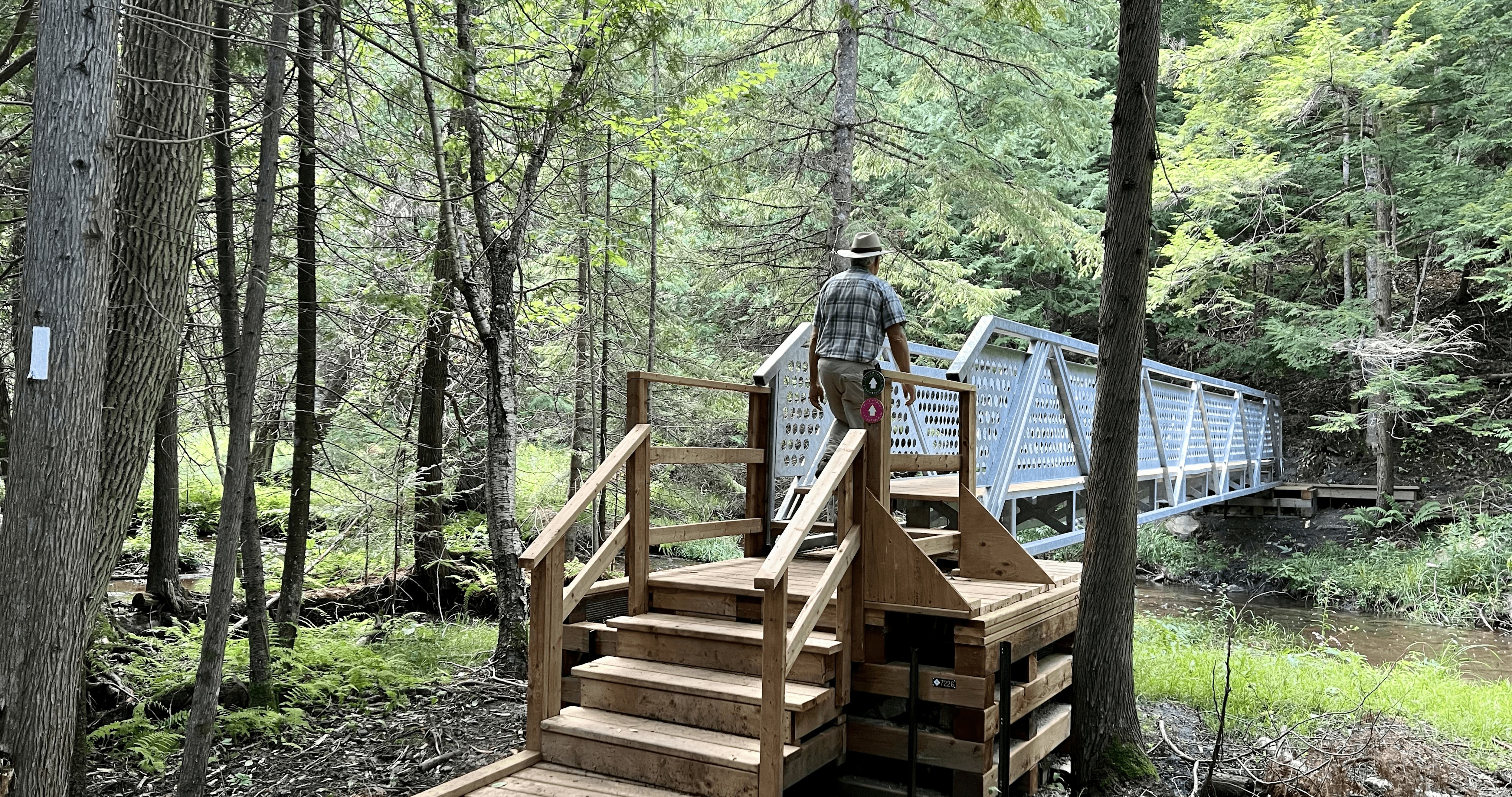
WEDNESDAY WALKERS - Hogg's Falls Bridges and Walkways
https://hikes.brucetrail.org/event/wednesday-walkers-hoggs-falls-bridges-and-walkways/Sorry, the registration cut-off time for this hike has been reached.Not a member? Click here to join today!Hosting Club: Beaver Valley
Location (Google Maps): Meet in the parking lot of Hogg’s Falls, km 67.5, Map 26, Edition 30
Hike Leader(s): Margaret Yaraskavitch Click here to contact the hike leader.
Pace: Medium
Terrain: Moderate, Some steep sections
Length of Hike: 5 kmDescription
Our hike takes us along a route that showcases much of the new construction that has recently been completed in the Hogg’s Falls area. Multiple bridges across the Boyne River allow for hiking loops. We will walk southward from the parking lot along the Main Trail and then we will cross the Boyne River. The Trail rises well above the Boyne River meaning there’s some steep inclines. Another bridge is crossed to return to the other side of the Boyne and then we include a loop into uplands. A visit to see the Falls is a special view.
Good Companions -McCormack Trails
https://hikes.brucetrail.org/event/good-companions-mccormack-trails/Sorry, the registration cut-off time for this hike has been reached.Not a member? Click here to join today!Hosting Club: Iroquoia
Category: Good Companions
Location (Google Maps): Delotteville Park. on Newcombe Road, south of Davidson Blvd. DundasHike Leader(s): Mary Rose Click here to contact Hike Leader(s)
Pace: Leisurely – 3km/hr or less
Terrain: Moderate – Some hills and/or some poor footing
Distance: 6KDescription
We will meet at Delottville Park on Newcombe Road. Dundas. Take Governors Road from Dundas and turn right onto Davidson Blvd. Left onto Pirie and then right onto Newcombe. There is plenty of on street parking. From the park we walk north to the Davidson Blvd. entrance for the Bruce Trail. After a walk through the woods we reach the McCormack trails. There are a couple of hills but easy walking under foot. Great views at top of hill.Evening Hike in Owen Sound followed by an opportunity for Refreshments
https://hikes.brucetrail.org/event/evening-hike-in-owen-sound-followed-by-an-opportunity-for-refreshments-2/Sorry, the registration cut-off time for this hike has been reached.Not a member? Click here to join today!Hosting Club: Sydenham
Category: An evening walk.
Location (Google Maps): Meet in the municipal parking lot by the river on the west side of 1st Ave. E between 7th St. E and 8th St. E in Owen Sound.Hike Leader(s): Harriet Nixon Click here to contact Hike Leader(s)
Pace: Brisk: 4 to 5 km/h
Terrain: Moderate: Some hills and/or poor footing
Distance: Approx 5 kmDescription
Join us for an evening hike exploring Owen Sound trails and neighbourhoods, followed by an opportunity for refreshments. There is no need to show up 15 minutes early. The hike will leave at 7:00 pm. For further information contact Hike Leader Harriet Nixon at harrietnixon@bmts.com or Cell 519-373-6598. - 05October 5, 2023
8:00 am Long Hike Jordan to Moyer / Louth
https://hikes.brucetrail.org/event/800-am-long-hike-jordan-to-moyer-louth-61/Sorry, the registration cut-off time for this hike has been reached.Not a member? Click here to join today!Hosting Club: Niagara
Category: In and Out
Location (Google Maps):Jordan Hollow Park 3039 King St Jordan
Hike Leader(s): Alan Laver Click here to contact Hike Leader(s)
Pace: Medium
Terrain: Moderate
Distance: 10kDescription
From Jordan Hollow Hike the main trail to Upper and Lower Balls Falls, Moyer Road or Louth and Return. You must register for each hike. Bring Poles, sunscreen, bug spray , snack and a drink and dress for the weather
9:15 Short Hike - Jordan Hollow
https://hikes.brucetrail.org/event/915-short-hike-jordan-hollow-77/Sorry, the registration cut-off time for this hike has been reached.Not a member? Click here to join today!Hosting Club: Niagara
Category: Loop
Location (Google Maps): Jordan Hollow Park, Jordan StationHike Leader(s): Bill Russell Click here to contact Hike Leader(s)
Pace: Medium
Terrain: Strenuous
Distance: 6 kmsDescription
Hike the main and side trails around Jordan Hollow and Ball’s Falls. Bring water and hiking boots.Iroquoia End-to-End Hike 5 of 10
https://hikes.brucetrail.org/event/iroquoia-end-to-end-hike-5-of-10/Sorry, the registration cut-off time for this hike has been reached.Not a member? Click here to join today!Hosting Club: Caledon Hills
Category: End-to-End
Location (Google Maps): Meet at Old Guelph Rd. km 65.8. Shuttle to start at City View Park.Hike Leader(s): Nancy Mooney Click here to contact Hike Leader(s)
Pace: Medium – 3 to 4 km/hour
Terrain: Moderate – some hills and/or some poor footing, Strenuous – hilly with steep climbs and some poor footing
Distance: From 76.9 to 65.8 plus City View Side Trail, 11.4 km. Map 9Description
This is the fifth hike of ten and takes us through Kerncliff Park and Waterdown Woods to Great Falls and a lookout. The hike continues along valley slopes, crosses a bridge then Snake Rd., passes through woods and along an old quarry to then pass through the Highway 6 tunnel to vehicles.Wiarton to Lion's Head #1: Wiarton to Malcolm Bluff
https://hikes.brucetrail.org/event/wiarton-to-lions-head-1-wiarton-to-malcolm-bluff/Sorry, the registration cut-off time for this hike has been reached.Not a member? Click here to join today!Hike open to BTC Members only.
Hosting Club: Dufferin Hi-Land
Category: General Hike
Location (Google Maps): Where the Purple Valley Access Trail meets Wright’s Crescent .5 km north of km 15.6, BTC Map 36.Hike Leader(s): Stuart Law Click here to contact Hike Leader(s)
Pace: Medium
Terrain: Slippery and Steep Sections, Slippery Sections Likely, Strenuous
Distance: 16.1 kmsDescription
Join us rain or shine for this series of Peninsula shuttle hikes from Wiarton to Lion’s Head. The terrain is demanding but stunning. Hikes range from 15 to 19 km. See individual hike descriptions for details. Please be ready for rocks, poison ivy, bugs and ticks. Hiking boots and poles mandatory. Lots of climbing, some mud and a lot of laughs. Please arrive 15 minutes ahead of time because our departure times are firm. Please bring your own first aid kit with moleskin, 2.5L water, lunch, snack and a change of footwear and a garbage bag (for the shuttle). Please be prepared to use your vehicle for the shuttle. No dogs and no dropouts. Km references are to 31st Edition Bruce Trail Reference. - 06October 6, 2023

9:00 am Niagara-on-the-Lake Tour
https://hikes.brucetrail.org/event/900-am-niagara-on-the-lake-tour-14/Sorry, the registration cut-off time for this hike has been reached.Not a member? Click here to join today!Hosting Club: Niagara
Category: Urban
Location (Google Maps): Veterans Memorial Park, park just outside the park on King StreetHike Leader(s): Robin Garrett Click here to contact Hike Leader(s)
Pace: Medium
Terrain: Easy
Distance: 6-7 kmDescription
Each Friday we will explore different neighbourhoods, trails and parkland throughout Historic Niagara-on-the-Lake.Moderate pace with some weeks entirely on sidewalks and roads while others may include a mix of trails and paved pathways. Great way to build up endurance for longer more strenuous hikes.
Prepare for cooler windy conditions on open parkland and along Lake Ontario and Niagara River trails.
Plan to stay for conversation and a warm cup of coffee or tea at Sweets & Swirls, Community Centre, Niagara Stone Road, NOTL
Wiarton to Lion's Head #2: Malcolm Bluff to Cape Croker
https://hikes.brucetrail.org/event/wiarton-to-lions-head-2-malcolm-bluff-to-cape-croker/Sorry, the registration cut-off time for this hike has been reached.Not a member? Click here to join today!Hike open to BTC Members only.
Hosting Club: Dufferin Hi-Land
Category: General Hike
Location (Google Maps): Cape Croker Park camp ground entrance. Km 33.3 BTC Map36.Hike Leader(s): Stuart Law Click here to contact Hike Leader(s)
Pace: Medium
Terrain: Slippery and Steep Sections, Slippery Sections Likely, Strenuous
Distance: 18.2 kmsDescription
Join us rain or shine for this series of Peninsula shuttle hikes from Wiarton to Lion’s Head. The terrain is demanding but stunning. Hikes range from 15 to 19 km. See individual hike descriptions for details. Please be ready for rocks, poison ivy, bugs and ticks. Hiking boots and poles mandatory. Lots of climbing, some mud and a lot of laughs. Please arrive 15 minutes ahead of time because our departure times are firm. Please bring your own first aid kit with moleskin, 2.5L water, lunch, snack and a change of footwear and a garbage bag (for the shuttle). Please be prepared to use your vehicle for the shuttle. No dogs and no dropouts. Km references are to 31st Edition Bruce Trail Reference.Slough of Despond loop
https://hikes.brucetrail.org/event/slough-of-despond-loop-3/Sorry, the registration cut-off time for this hike has been reached.Not a member? Click here to join today!Hosting Club: Sydenham
Category: General Hike
Location (Google Maps): Kemble Arena parking lot for carpooling. 319897 Kemble Rock Road. Meet at 12:45. Limited parking at the trail head.Hike Leader(s): Carol Graham-Mullin Click here to contact Hike Leader(s)
Pace: Medium: 3 to 4 km/h
Terrain: Moderate: Some hills and/or poor footing
Distance: 5.5 kmDescription
President’s Path and Slough of Despond loop with an optional add on to view Skinner’s Bluff. This hike is relatively flat through fields and forests. Note : 3 stiles to climb, no walk around. Some crevices. Magnificent views of the bay and Slough of Despond. We can choose to take a short extension at the end to the lookout over Skinner’s Bluff (extra 30 minutes). If you are unable to register, please call or text the leader at 226-787-8804. - 07October 7, 2023
Fall Colours Club End-to-End
https://hikes.brucetrail.org/event/fall-colours-club-end-to-end/Sorry, the registration cut-off time for this hike has been reached.Not a member? Click here to join today!This is a Multi-Day Hike
You are signing up for the following dates:
2023-10-07, 2023-10-08, 2023-10-09Hosting Club: Caledon Hills
Category: End-to-End
Location (Google Maps): Fung Loy Kok Taoist Tai Chi-International Centre, 248305 Side Road 5, Mono, ON L9W 6C3
GPS Co-ordinates: 43.975421, -79.989252.From Airport Road, turn east onto Side Road 5. Drive 270 metres to the entrance of the International Centre on the left. Turn right onto the first gravel road and proceed towards the pagoda-styled building. Park on the shoulder of this circular driveway. Please do not park in the main parking lot near the office. The buildings and facilities of the International Centre are off limits to participants during this Bruce Trail event.
Meeting Locations for Day 2 and Day 3 are noted in the hike description.
Hike Leader(s): Sandy Green Click here to contact Hike Leader(s)
Pace: Brisk – 4 to 5 km/hour
Terrain: Strenuous – hilly with steep climbs and some poor footing
Distance: 72.5 kilometresDescription
Make plans to complete the full 72.5 kilometres of the Caledon Hills section over the Thanksgiving long weekend.The bus will leave at 8:00 a.m. sharp, each day. Please plan to arrive at least 20 – 30 minutes before the departure time.
On Saturday, meet at the Fung Loy Kok Taoist Tai Chi-International Centre, 248305 Side Road 5, Mono, ON, 43.975421, -79.989252.
The bus will take participants to the northern end of the Caledon Hills section, at County Rd. 8 and 3rd Line EHS. The group will then hike south, back to the International Centre. Checkpoints are located 11 km, 17 km [Cut-off Time: 1:00 pm], and 26.5 into the hike.
On Sunday, meet at km 21.0, the north/east corner of Escarpment Side Road and Heart Lake Road. Park on the north side of Escarpment Side Road, well off of the road, 43.859911, -79.947606.
The bus will take hikers to km 0.0 on Creditview Road. Participants will then hike back to the meeting place on Escarpment Side Road.
Checkpoints are located 9.5 km [Cut-off Time: 11:00] and 21.0 km into the hike.
On Monday, meet at the Fung Loy Kok Taoist Tai Chi-International Centre.
The bus will take participants to Escarpment Side Road and Heart Lake Road. Everyone will then hike back to the International Centre.
Checkpoints are located 7.0 km, 14. km [Cut-off Time: 12:15 pm], and 25.0 km into the hike.
Please note that on Saturday and Monday, the final checkpoint (the end of the hike) is slightly off the Bruce Trail. There will be signs in place to direct hikers. Also note that the meeting place on Sunday is different than the other two days.
Car Hike: Erindale Park Mississauga
https://hikes.brucetrail.org/event/car-hike-erindale-park-mississauga/Sorry, the registration cut-off time for this hike has been reached.Not a member? Click here to join today!Hosting Club: Toronto
Category: Car Hike
Location (Google Maps): Erindale Park Dundas Street west and Mississauga Road
Please park in parking lot after entering the parkHike Leader(s): Mohammad Aghamiri , 19 Willowbrook Rd Click here to contact Hike Leader(s)
Pace: Moderate
Terrain: VariableDescription
Please join us to hike along Credit river and see how salmon fishes go upstream and see the view of widest river around GTA,Some safety procedures during the hike:
1-Hikers must stay between the leader and the sweep.
2-Hikers must advise the leader or the sweep if they wish to leave the group.
3- Hikers must follow the whistle instructions: 1 blast- stay where you are; 2 blasts come to the leader; 3 blasts – come to the leader quickly.
4-Hike leader may request volunteers to stop at trail intersections, they need to help hikers to the direction the group walk and wait till they see the sweep .
5-Hikers have to make sure they can see the persons behind and in front of them.
Bus Hike: Toronto Section E2E 3 of 4 - Scotsdale Farm/Terra Cotta
https://hikes.brucetrail.org/event/bus-hike-toronto-section-e2e-3-of-4-scotsdale-farm-terra-cotta/Sorry, the registration cut-off time for this hike has been reached.Not a member? Click here to join today!Trip Information
Departure Time: 08:30
Return to City Time: 17:30
Departure Point: Kipling Departure PointOptional Items
Hosting Club: Toronto
Category: Bus Hike
Location (Google Maps): Toronto Section – Scotsdale Farm/Terra CottaHike Leader(s): Tom Swales & Celia Ho Click here to contact Hike Leader(s)
Pace: Moderate
Terrain: Hilly, Rocky, Variable
Distance: 15 kmDescription
Join us to hike the Toronto section of the Bruce Trail in a series of four moderate pace/moderate distance Level 2 hikes (15-16 km a day). Those who complete all 4 hikes will qualify for the Toronto club’s diamond E2E badge. The badge fee ($5 members/$15 non-members) will be collected on Hike #3.Members may alternatively choose to use the hikes to earn the new stained glass Limehouse stone bridge fundraiser badge. Available to members only the badge fee is $30 and proceeds go to protecting and preserving the Bruce Trail. Please contact the Hike Leader if you are interested in earning the fundraiser badge for further instructions. This badge can be earned only on one of the series of special group hikes led by a BTC Hike Leader and not individually.
Hikers who complete all 4 hikes will qualify for either the diamond badge or stained glass fundraiser badge, as they have chosen.
Any hikers are welcome to join the hikes regardless of working towards one of E2E badges.
There will be a refreshment/social stop in Georgetown after the hike before returning to the Kipling Station departure point by 5:30 PM
** Hikers are required to bring a mask and wear it on the bus. Masks must fit properly and cover the nose, mouth and chin. For the highest level of protection against Covid-19, respiratory viruses or the flu, KN95 or N95 masks are recommended. **
Looping through Sydenham # 7 of 9
https://hikes.brucetrail.org/event/looping-through-sydenham-7-of-9/Sorry, the registration cut-off time for this hike has been reached.Not a member? Click here to join today!Hosting Club: Blue Mountains
Category: Organized Hike
Location (Google Maps):Hike Leader(s): David Little Click here to contact Hike Leader(s)
Pace: Medium – 3 to 4 km/hr
Terrain: Moderate – Some hills and/or some poor footing
Distance: 11kmDescription
Glen Side Trail, Ron Savage Side Trail, Lindenwood Side Trail and Ross McLean Side Trail 7 of 9 hikes Start time: 8:30AM Hikers meet at trailhead at 8:30AM, arrange your own carpooling.
Contact hike leader for details where to meet up
9:00 Cave Spring Witch Hunt
https://hikes.brucetrail.org/event/900-cave-spring-witch-hunt-8/Sorry, the registration cut-off time for this hike has been reached.Not a member? Click here to join today!Hosting Club: Niagara
Category: In and Out
Location (Google Maps):Parking lot Quarry Road Beamsville
Hike Leader(s): Bill Russell Click here to contact Hike Leader(s)
Pace: Leisurely
Terrain: Moderate
Distance: 6kDescription
Discover the history of the 19th Century Quarry Pioneers and the Cave Spring Witch. Complete this hike and count it towards the Screaming Tunnel Badge
9:00 Port Dalhousie - Jaycee Gardens & Green Ribbon Trail
https://hikes.brucetrail.org/event/900-port-dalhousie-jaycee-gardens-green-ribbon-trail-3/Sorry, the registration cut-off time for this hike has been reached.Not a member? Click here to join today!Hosting Club: Niagara
Category: Urban
Location (Google Maps):Jaycee Gardens Park, 543 Ontario St., St Catharines, L2N 4N4
Hike Leader(s): Karen Couch Click here to contact Hike Leader(s)
Pace: Medium
Terrain: Easy
Distance: 10 kmDescription
This urban hike will form a loop, first crossing over Martindale Pond, then winding through town to the Green Ribbon Trail and then back close to Lake Ontario.Wiarton to Lion's Head #3: Cape Croker to Jackson's Cove
https://hikes.brucetrail.org/event/wiarton-to-lions-head-3-cape-croker-to-jacksons-cove/Sorry, the registration cut-off time for this hike has been reached.Not a member? Click here to join today!Hike open to BTC Members only.
Hosting Club: Dufferin Hi-Land
Category: General Hike
Location (Google Maps): BTC parking lot on Jackson’s Cove Road at the top of the hill just west of the trail. Km 51.9 BTC Map 37.Hike Leader(s): Stuart Law Click here to contact Hike Leader(s)
Pace: Medium
Terrain: Slippery and Steep Sections, Slippery Sections Likely, Strenuous
Distance: 18.6 kmsDescription
Join us rain or shine for this series of Peninsula shuttle hikes from Wiarton to Lion’s Head. The terrain is demanding but stunning. Hikes range from 15 to 19 km. See individual hike descriptions for details. Please be ready for rocks, poison ivy, bugs and ticks. Hiking boots and poles mandatory. Lots of climbing, some mud and a lot of laughs. Please arrive 15 minutes ahead of time because our departure times are firm. Please bring your own first aid kit with moleskin, 2.5L water, lunch, snack and a change of footwear and a garbage bag (for the shuttle). Please be prepared to use your vehicle for the shuttle. No dogs and no dropouts. Km references are to 31st Edition Bruce Trail Reference.
New Badge! Beaver Valley Geology Hike #3
https://hikes.brucetrail.org/event/new-badge-beaver-valley-geology-hike-3/Sorry, the registration cut-off time for this hike has been reached.Not a member? Click here to join today!Hosting Club: Beaver Valley
Location (Google Maps): Meet in the Metcalfe Rock parking lot on 10th Line, near km 27.9
Hike Leader(s): Glenda Collings Click here to contact the hike leader.
Pace: Medium
Terrain: Moderate, Some rocky footing, Some steep sections, Strenuous
Length of Hike: 10.4 kmDescription
This is a series of 7 hikes to earn the Beaver Valley Geology badge. We will use the criteria listed in Beth Gilhespy’s book, Walking Through Time, Exploring Niagara Escarpment Geology in the Beaver Valley Bruce Trail Section. We’ll boost our knowledge of the local geology along the way as we take the required photos. Hikers are welcome to join any or all of the hikes, however, they must complete all 7 hikes to earn the badge. Bring sufficient water and snacks.Hike Three: The Mill Creek Valley
COVID-19 Precautions Before, During and After your Hike
- Each hiker joining a Bruce Trail Club organized hike must perform a self-screening check before hiking.
Find Ontario’s self-assessment tool here: https://covid-19.ontario.ca/self-assessment/ - If you are experiencing COVID-19 symptoms, stay home.
- Personal Protective Equipment:
- Hikers may choose to wear masks
Transportation
It is the Bruce Trail Conservancy’s current policy that car shuttles are allowed. It is at the discrepancy of individual hike leaders to make that decision.
Other Guidelines
- Arrive 15 minutes before the start of the hike.
- Wear sturdy footwear and appropriate attire for the weather and the terrain.
Hiking poles are a good idea in any season, especially if the terrain is rocky or slippery. In winter, snowshoes or icers/crampons are needed when conditions dictate.
Wearing appropriate clothing and footwear prevents injuries and shows consideration for a safe and positive group hiking experience. - Always carry I.D. and your health card.
- Bring sufficient water and snacks (or lunch if indicated). A minimum of 1L of water is recommended on all hikes, and 3L is recommended for long, challenging hikes in the heat of the summer.
- Bring sunscreen and insect repellent (for spring and summer hikes).
- Bring your own first aid kit.
- Please leave dogs at home.
Taylor Creek & West Don Ravine hike to Lawrence Subway
https://hikes.brucetrail.org/event/taylor-creek-west-don-ravine-hike-to-lawrence-subway/Sorry, the registration cut-off time for this hike has been reached.Not a member? Click here to join today!Hosting Club: Toronto
Category: Urban Walk
Location (Google Maps): Start at Victoria Park subway station ticket collector. Several dropouts along the way. Final destination is Lawrence subway station on Yonge Street.Hike Leader(s): Ray Berzins Click here to contact Hike Leader(s)
Pace: Moderate
Terrain: Flat
Distance: 14 kmDescription
From Victoria Park subway we shall walk northeast along the Taylor Creek to the Don River, follow the West Don River to Sunnybrook Park, then to Sherwood Park and then to Alexander Muir Memorial Park ending up at Lawrence subway station on Yonge Street. We shall have a picnic halfway so bring a sandwich and a thermos. - Each hiker joining a Bruce Trail Club organized hike must perform a self-screening check before hiking.