|
Sun | Mon | Tue | Wed | Thu | Fri | Sat |
|---|
May | May | 1 | 2 | 3 | 4 | 5 |
6 | 7 - Evening Hike in Owen
12:00 AM 06/07/2021 https://hikes.brucetrail.org/event/evening-hike-in-owen/2021-06-07/
| 8 | 9 | 10 | 11 | 12 |
13 - Derby Forest Trails
1:15 PM 06/13/2021 https://hikes.brucetrail.org/event/derby-forest-trails-5/2021-06-13/
| 14 | 15 | 16 | 17 | 18  Niagara-on-the-Lake Tours Niagara-on-the-Lake Tours 9:00 AM-10:30 AM 06/18/2021 https://hikes.brucetrail.org/event/niagara-on-the-lake-tours-5/2021-06-18/
| 19 - 12 Mile Creek Loop
9:00 AM-12:30 PM 06/19/2021 https://hikes.brucetrail.org/event/12-mile-creek-loop-5/2021-06-19/  9am DeCew – 12 Mile Creek Loop 9am DeCew – 12 Mile Creek Loop 9:00 AM-12:30 PM 06/19/2021 https://hikes.brucetrail.org/event/9am-decew-12-mile-creek-loop/2021-06-19/ - Rockway Conservation Area
9:00 AM-10:30 AM 06/19/2021 https://hikes.brucetrail.org/event/rockway-conservation-area-4/2021-06-19/ Click here for more information or to register Hosting Club: Niagara
Category: In and Out
Location (Google Maps): Rockway Conservation Area Hike Leader(s): Diane Marlatt Click here to contact Hike Leader(s)
Pace: Medium
Terrain: Moderate
Distance: Approximately 6 km Description
Starting out at Rockway Community Centre we will hike the side trail and main trail. Beautifully wooded, hilly area with water fall views. Terrain can be challenging with rocks & steep hills. Pace is moderate. Hiking boots & poles are strongly recommended.
- Hike #2 Loree Forest Lollipop
9:00 AM-1:30 PM 06/19/2021 https://hikes.brucetrail.org/event/hike-2-loree-forest-lollipop/2021-06-19/ Click here for more information or to register Hosting Club: Blue Mountains
Category: Blue Mountain Hike
Location (Google Maps): Hike meets in the parking lot behind Tim Horton’s on First St. in Collingwood.
Hike Leader(s): Michael Treuman (416) 518-0489 Click here to contact Hike Leader(s)
Pace: Leisurely – 3 km/hr. or less
Terrain: Easy – Mostly flat and usually good footing
Distance: 5 km Description
We will drive to the parking area on the 21st Sideroad at the Loree Forest.
This is a circular hike that proceeds north along the access road to the Loree Forest.
We then hike east along a forest trail and then west to arrive at the top of the Georgian Peaks ski club. Then we proceed west to arrive at the start point. There are several views of the Bay along the way.
Bring a snack and water.
Optional lunch stop afterwards at Ravenna General Store.
Map: 24 Edition 30
- Fox Ridge Rd to Ken Young Side Trail
9:00 AM-1:00 PM 06/19/2021 https://hikes.brucetrail.org/event/hike-1-fox-ridge-rd-to-ken-young-side-trail/2021-06-19/ Click here for more information or to register Hosting Club: Blue Mountains
Category: Blue Mountain Hike
Location (Google Maps): Hike meets in the parking lot behind Tim Horton’s on First St. in Collingwood.
Hike Leader(s): Annette Sandberg (705) 795-9700 Click here to contact Hike Leader(s)
Pace: Medium – 3 to 4 km/hr
Terrain: Moderate – Some hills and/or some poor footing
Distance: 9 km Description
We will drive to and park the cars at the westerly end of Fox Ridge Rd in the Beaver Valley Section.
We begin to hike south at km 39.3 with descents and an ascent through a spectacular natural pass.
Continuing south to km 43.5, we will then take the Ken Young Side Trail
and hike north to meet up with the white blazed trail, retracing our steps back to the cars.
Bring a snack or lunch and water.
|
20 - A Ramble on Kemble Mountain
1:00 PM 06/20/2021 https://hikes.brucetrail.org/event/a-ramble-on-kemble-mountain/2021-06-20/ Click here for more information or to register Hosting Club: Sydenham
Category: General Hike
Location (Google Maps): Bruce Trail parking area on the left side of Kemble Rock Road, north of Concession 24 (at km 149.7) Map 34
Hike Leader(s): Danuta Valleau Click here to contact Hike Leader(s)
Pace: Medium: 3 to 4 km/h
Terrain: Moderate: Some hills and/or poor footing
Distance: 4.5 km Description
This is a loop hike on the main trail to km 154.2, followed by a 3.3 km hike back to the start along Cape Road and up W hill.
 Merritt Island Merritt Island 2:00 PM-3:30 PM 06/20/2021 https://hikes.brucetrail.org/event/merritt-island-12/2021-06-20/
| 21 - Rotary Park
9:00 AM-10:30 AM 06/21/2021 https://hikes.brucetrail.org/event/rotary-park-8/2021-06-21/ - FIrst Day of Summer-Summer Solstice
9:00 AM-12:00 PM 06/21/2021 https://hikes.brucetrail.org/event/first-day-of-summer-summer-solstice/2021-06-21/ Click here for more information or to register Hosting Club: Blue Mountains
Category: Blue Mountain Hike
Location (Google Maps): Hike meets in the parking lot behind Tim Horton’s on First St. in Collingwood.
Hike Leader(s): Kelly-Leigh Thomas (519) 501-8170 Click here to contact Hike Leader(s)
Pace: Medium – 3 to 4 km/hr
Terrain: Moderate – Some hills and/or some poor footing
Distance: 5 km Description
We will drive to the end of the 6th Line at km 13.7 (turn off 119).
The Trail passes through a hardwood bush and abandoned farm fields to enter a pretty wooded area.
It then winds along the edge of a ravine, carved out by a small stream that is the headwaters of Indian Brook.
The bubbling brook drops over dolostone ledges as it rushes on to Georgian Bay. The Trail passes a small flowerpot formation created by wave action along the shore of an ancient glacial lake. The land crossed by this loop trail was one of the earliest purchases in the 1980s under the Bruce Trail’s Land Acquisition Program. Margaret Paull was one of those early Bruce Trail volunteers who made such a dream possible.
Bring a snack and water.
Map: 24 Edition 30
| 22 - Long Hike Wiley Road Short Hills
8:00 AM-10:30 AM 06/22/2021 https://hikes.brucetrail.org/event/long-hike-wiley-road-short-hills-17/2021-06-22/ - Long Hike Wiley Road Short Hills
8:30 AM-11:00 AM 06/22/2021 https://hikes.brucetrail.org/event/long-hike-wiley-road-short-hills-26/2021-06-22/ - 9:15am Short Hike, Pelham Road, Short Hills
9:15 AM-10:45 AM 06/22/2021 https://hikes.brucetrail.org/event/915am-short-hike-pelham-road-short-hills-2/2021-06-22/ - Clearview and Pines Loop
9:30 AM 06/22/2021 https://hikes.brucetrail.org/event/clearview-and-pines-loop/2021-06-22/ Click here for more information or to register Hosting Club: Sydenham
Category: General Hike
Location (Google Maps): Roadside parking on west side of 8th Conc. North, 0.8 km north of Hwy 26. (To the east of km 73.7 ) Map 31
Hike Leader(s): Franziska Edney Click here to contact Hike Leader(s)
Pace: Medium: 3 to 4 km/h
Terrain: Moderate: Some hills and/or poor footing
Distance: 5.0 kms Description
This 2 hr hike around the Clearview Loop (2.8 km) and Pines Loop (1.8 km) takes us through a variety of forest and along a stream valley, over some boardwalks and bridges. After a good rain there could be some muddy sections. We can visit the famous polish tree just a short 200m hike away from the loop.
- Scotsdale Farm
10:00 AM-1:00 PM 06/22/2021 https://hikes.brucetrail.org/event/scotsdale-farm-10/2021-06-22/ Click here for more information or to register Hosting Club: Iroquoia
Category: General Hike
Location (Google Maps): Scotsdale Farm 13807 Trafalgar Rd.
Hike Leader(s): Hike System Administrator Click here to contact Hike Leader(s)
Pace: Leisurely – 3km/hr or less
Terrain: Moderate – Some hills and/or some poor footing
Distance: 10-12 km. Description
This is a favourite spot to hike. Scotsdale Farm was donated to the Ontario Heritage Foundation by the Bennett Family. It is crisscrossed by both Main Bruce Trail and blue side trails. The terrain varies with old fields, road allowance, hills, ravines with streams and rocky sections. There will be a shorter version of about 10 km. and a longer one of 12 km. Bring a lunch, sunscreen and insect repellent. Poles would be useful. Park in the main parking lot closest to the farm buildings. Leader: Anne Armstrong 905 617 3937 hikingrandma@gmail.com
- Two Loops and Lunch in Beaver Valley
10:30 AM-3:00 PM 06/22/2021 https://hikes.brucetrail.org/event/two-loops-and-lunch-in-beaver-valley/2021-06-22/ Click here for more information or to register Hosting Club: Caledon Hills
Category: Tuesday Hikers
Location (Google Maps): Km 13.7 on Map 24. From Shelburne, take Rd. 124 north. Turn left on Grey Rd. 4, then right on Grey Rd. 2. In Ravenna, turn right on Rd. 119, then left to dead end of 6th Line.
Hike Leader(s): Barbara Euler Click here to contact Hike Leader(s)
Pace: Medium – 3 to 4 km/hour
Terrain: Moderate – some hills and/or some poor footing
Distance: 14 km Description
We will hike a loop using the Main Trail and the Margaret Paull Side Trail through forest and fields featuring small flowerpots formed by an ancient sea and some waterfalls. Then we will drive into Ravenna where we can pick up the famous Country Market sandwiches (or bring your own lunch if you prefer). We’ll drive to the Loree Forest to have our lunch and hike a loop with beautiful views over Georgian Bay.
| 23 - Hike #1 Hockley Valley -EARLY START 8:00AM
8:00 AM-3:30 PM 06/23/2021 https://hikes.brucetrail.org/event/hike-1-hockley-valley-early-start-800am/2021-06-23/ Click here for more information or to register Hosting Club: Blue Mountains
Category: Blue Mountain Hike
Location (Google Maps): Hike meets in the parking lot behind Tim Horton’s on First St. in Collingwood.
Hike Leader(s): David Little (705) 428-3022 Click here to contact Hike Leader(s)
Pace: Medium – 3 to 4 km/hr
Terrain: Moderate – Some hills and/or some poor footing, Strenuous – Hilly with steep climbs and some poor footing
Distance: 12 km Description
We will park in the parking lot east of km 61.5 on Hockley Valley Rd. in the Caledon Hills section. Starting on the white blazed trail we will climb, climb and climb until we reach the north end of the Isabel East Side Trail. We will then begin our descent via the Isabel East Side Trail
and the Tom East Side Trail before returning to the cars.
Bring lunch and water.
Map: 18 Edition 30
- Niagara Glen (Gorge)
9:00 AM-11:30 AM 06/23/2021 https://hikes.brucetrail.org/event/niagara-glen-gorge-7/2021-06-23/ 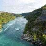 Click here for more information or to register Hosting Club: Niagara
Category: Hike
Location (Google Maps): Meet at the Niagara Glen Nature Centre Parking Lot 3050 Niagara Parkway
Hike Leader(s): Dan Wilson Click here to contact Hike Leader(s)
Pace: Medium
Terrain: Strenuous
Distance: 11 km Description
Hike deep in the Niagara Gorge, stairways lead to 4 kilometres of rugged paths that wind through this pristine pocket of Carolinian Forest, past prehistoric geological formations, wild flora and fauna. The Niagara Glen overlooks the rapid waters of the Niagara River. This is a strenuous hike! Good chance hikers will get wet!! Parking fee required!!!
- Hike #2: Nottawasaga Bluffs
9:00 AM-1:00 PM 06/23/2021 https://hikes.brucetrail.org/event/hike-2-nottawasaga-bluffs/2021-06-23/ Click here for more information or to register Hosting Club: Blue Mountains
Category: Blue Mountain Hike
Location (Google Maps): Hike meets in the parking lot behind Tim Horton’s on First St. in Collingwood.
Hike Leader(s): Paul Carnahan (705) 428-3022 Click here to contact Hike Leader(s)
Pace: Leisurely – 3 km/hr. or less
Terrain: Moderate – Some hills and/or some poor footing
Distance: 5 km Description
We will drive to the parking lot at 15/16 Sideroad in Singhampton and explore the Nottawasaga Bluffs.
This is a great place for hiking, offering several options in length, difficulty, beauty and views. We will will be doing a leisurely pace taking in the wonderful area.
Bring a snack and water.
Map: 22 Edition 30
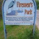
- Firemans Park Loop
9:00 AM-10:30 AM 06/23/2021 https://hikes.brucetrail.org/event/firemans-park-loop-10/2021-06-23/ - Cootes Paradise South Shore Trails
9:30 AM-11:30 AM 06/23/2021 https://hikes.brucetrail.org/event/cootes-paradise-south-shore-trails/2021-06-23/ Click here for more information or to register Hosting Club: Iroquoia
Category: General Hike
Location (Google Maps): Princess Point Parking Lot
Hike Leader(s): Ted Bossence Click here to contact Hike Leader(s)
Pace: Medium – 3 to 4 km/hr
Terrain: Moderate – Some hills and/or some poor footing
Distance: Approx 7-8 km Description
We will walk around Princess Point and then the South Shore Trails to McMaster University and back. Cancelled in case of rain. We will start sharp at 9:30 am. Parking fee unless you have an RBG parking pass. Usual COVID 19 protocols in effect.
| 24 | 25 | 26 - Barrow Bay Staircase, Peninsula EARLY start time 7:30am
7:30 AM-5:00 PM 06/26/2021 https://hikes.brucetrail.org/event/barrow-bay-staircase-peninsula-start-time-early-730am/2021-06-26/ Click here for more information or to register Hosting Club: Blue Mountains
Category: Blue Mountain Hike
Location (Google Maps): Hike meets in the parking lot behind Tim Horton’s on First St. in Collingwood.
Hike Leader(s): Dick Edwards (705) 445-5849 Click here to contact Hike Leader(s)
Pace: Medium – 3 to 4 km/hr
Terrain: Strenuous – Hilly with steep climbs and some poor footing
Distance: 6.5-7 km Description
We will drive from Collingwood to Lions Head (2hours) and follow Rd 9 to km 67.9
at the junction of the Barrow Bay Side Trail which has now become the white blazed trail after
printing edition 30.
We follow this NEW trail to a very steep descent down the escarpment to the Georgian Bay shore.
We then follow a moderately rugged path just inside the treeline for 2km along an unspoiled rocky shoreline.
We then head back up via a steep zig zag among huge boulders until we meet a formerly impassable cliff,
now conquered by a spectacular wooden staircase built in 2020 by volunteers from the Peninsula BTC.
We will take a moment to appreciate the hard work
and beautiful views before continuing on an easy peasy walk to our end point.
The trail features cliffs, spectacular lookouts, and dense forests.
A long drive home but what a spectacular new section of our fabulous footpath to have experienced.
Bring snacks, lunch and water.
Map: 37/38 Edition 30
 Hunt for Edibles CANCELLED Hunt for Edibles CANCELLED 9:00 AM-11:00 AM 06/26/2021 https://hikes.brucetrail.org/event/hunt-for-edibles-2/2021-06-26/  Click here for more information or to register Hosting Club: Niagara
Category: Cancelled
Location (Google Maps): Bailey Bridge Parking Lot (West of 21st Street Jordan)
Hike Leader(s): Bill Russell Click here to contact Hike Leader(s)
Pace: Leisurely
Terrain: Easy
Distance: 6k Description
Learn to Forage for edible treats and snacks with Bill Russell Loop Hike through wooded trail and Jordan Village looking for edible flowers and plants.Feel free to bring your camera or smartphone & you can submit your findings to the Bruce Trail citizen science project on i-naturalist or submit to #nbtccitizenscience.
- Rockway Short Hills Return
9:00 AM-1:00 PM 06/26/2021 https://hikes.brucetrail.org/event/rockway-short-hills-return/2021-06-26/  Rockway to Short Hills & return 9AM Rockway to Short Hills & return 9AM 9:00 AM-1:00 PM 06/26/2021 https://hikes.brucetrail.org/event/rockway-to-short-hills-return-9am/2021-06-26/
|
27 - New Date & Time – Harrison Park and Inglis Falls
1:00 PM 06/27/2021 https://hikes.brucetrail.org/event/new-date-time-harrison-park-and-inglis-falls/2021-06-27/ Click here for more information or to register Hosting Club: Sydenham
Category: General Hike
Location (Google Maps): Parking lot in Harrison Park by the Harrison Park Inn (north of km 96.7) Map 32
Hike Leader(s): Sheri Hatcher Click here to contact Hike Leader(s)
Pace: Brisk: 4 to 5 km/h
Terrain: Moderate: Some hills and/or poor footing, There might be muddy sections., There might be sections with water on the trail.
Distance: 10 km Description
On this brisk hike we encounter a variety of terrain. We start on the Harrison Park Side Trail, which meets both the Main Trail (upper trail) and the Palisades Side Trail (lower trail). The Main Trail is quite spectacular with rocky and steep sections. Weather permitting, we will do this section but if it appears too slippery we will do the Palisades Side Trail which will take us back to the Main Trail. From there we head to Inglis Falls and return via the Creamery Side Trail to Harrison Park.
- Louth Conservation Area
2:00 PM-3:30 PM 06/27/2021 https://hikes.brucetrail.org/event/louth-conservation-area-9/2021-06-27/ Click here for more information or to register Hosting Club: Niagara
Category: Loop
Location (Google Maps): Louth Conservation Area Hike Leader(s): Bruce Manion Click here to contact Hike Leader(s)
Pace: Leisurely
Terrain: Moderate
Distance: Approximately 6 km Description
Hike will start out at Louth Conservation Area parking lot and hike the Louth Side trail and main trail to form a loop through the beautifully wooded conservation area with spectacular water fall views. The terrain can be challenging with lots of rocks, crevices and hills. Hiking boots & poles are strongly recommended. Pace is medium to brisk at approximately 4 km/hr.
| 28 - Rotary Park
9:00 AM-10:30 AM 06/28/2021 https://hikes.brucetrail.org/event/rotary-park-9/2021-06-28/
| 29 - Long Hike Wiley Road Short Hills
8:00 AM-10:30 AM 06/29/2021 https://hikes.brucetrail.org/event/long-hike-wiley-road-short-hills-18/2021-06-29/ - Long Hike Wiley Road Short Hills
8:30 AM-11:00 AM 06/29/2021 https://hikes.brucetrail.org/event/long-hike-wiley-road-short-hills-27/2021-06-29/ - Forks of the Credit
9:00 AM-2:30 PM 06/29/2021 https://hikes.brucetrail.org/event/forks-of-the-credit-8/2021-06-29/ Click here for more information or to register Hosting Club: Caledon Hills
Category: Tuesday Hikers
Location (Google Maps): Mississauga Rd. intersection with Elora-Cataract Trailway.
Driving direction: From Highway 401, north on Mississauga Rd., pass through Belfountain village, after crossing Cataract Rd. and Elora-Cataract Trailway, park on either side of the road.
Hike Leader(s): Mohammad Shafiq Click here to contact Hike Leader(s)
Pace: Medium – 3 to 4 km/hour
Terrain: Moderate – some hills and/or some poor footing
Distance: 13 km Description
Will enter Forks of the Credit Conservation Area using the Elora-Cataract Trailway and hike the main Bruce Trail, Mill Pond, Cataract and Dorothy Medhurst Side Trails and parts of conservation trails. Lunch break at a lovely spot on the Credit River, arguably one of the best spots on the river.
COVID regulations to be observed throughout the hike, keeping a distance of 2 meters between hikers and wearing face mask when required. Bring your own bug spray and hand sanitizer, not to be shared.
Bring 2 litres of water and snack; poles are recommended.
- 9:15am Short Hike, Pelham Road, Short Hills
9:15 AM-10:45 AM 06/29/2021 https://hikes.brucetrail.org/event/915am-short-hike-pelham-road-short-hills-3/2021-06-29/
| 30 - Leisurely Pace: Bibbulmun Friendship Trail Start time: EARLY 8:00AM
8:00 AM-1:30 PM 06/30/2021 https://hikes.brucetrail.org/event/leisurely-pace-bibbulmun-friendship-trail-start-time-early-830am/2021-06-30/ Click here for more information or to register Hosting Club: Blue Mountains
Category: Blue Mountain Hike
Location (Google Maps): Hike meets in the parking lot behind Tim Horton’s on First St. in Collingwood.
Hike Leader(s): Allison Thomas (705) 444-4616 Click here to contact Hike Leader(s)
Pace: Medium – 3 to 4 km/hr
Terrain: Moderate – Some hills and/or some poor footing
Distance: 7 km Description
This is one of our Friendship trails running along BTC trails and other conserved
land north of Boyne Valley Provincial Park.
We will park at km 29.4 on 1st Line E in the Dufferin Hi-Land section.
The 7km figure eight hike will follow the white blazed trail to km 25.4,
looping back to the parking lot via the Oliver Creek Side Trail and the Moss Haven Side Trail.
Bring a lunch/snack and water.
The Bibbulmun Track in Western Australia stretches 1,000 km
from Kalamunda in the Perth Hills to the historic town of Albany on the south coast.
Map: 20 Edition 30
- Medium Pace: Bibbulmun Friendship Trail Start time: EARLY 8:00AM
8:30 AM-2:00 PM 06/30/2021 https://hikes.brucetrail.org/event/medium-pace-bibbulmun-friendship-trail-start-time-early-800am/2021-06-30/ Click here for more information or to register Hosting Club: Blue Mountains
Category: Blue Mountain Hike
Location (Google Maps): Hike meets in the parking lot behind Tim Horton’s on First St. in Collingwood.
Hike Leader(s): Terry Kimmerly (705) 351-2494 Click here to contact Hike Leader(s)
Pace: Medium – 3 to 4 km/hr
Terrain: Moderate – Some hills and/or some poor footing
Distance: 7 km Description
This is one of our Friendship trails running along BTC trails
and other conserved land north of Boyne Valley Provincial Park.
We will park at km 29.4 on 1st Line E in the Dufferin Hi-Land section.
The 7km figure eight hike will follow the white blazed trail to km 25.4, looping
back to the parking lot via the Oliver Creek Side Trail and the Moss Haven Side Trail.
Bring a lunch/snack and water.
The Bibbulmun Track in Western Australia stretches 1,000 km
from Kalamunda in the Perth Hills to the historic town of Albany on the south coast.
Map: 20 Edition 30
- Pacific Slope Friendship Trail
9:00 AM 06/30/2021 https://hikes.brucetrail.org/event/pcacific-slope-friendship-trail/2021-06-30/ 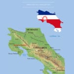 Click here for more information or to register Hosting Club: Beaver Valley Location (Google Maps): Meet in the Hogg’s Falls Parking lot on Lower Valley Road, Map 26 Edition 30, km 67.5
Hike Leader(s): Glenda Collings Click here to contact the hike leader.
Pace: Medium
Terrain: Moderate, Some rocky footing, Some steep sections
Length of Hike: 13.6 km Description
This will be an out and back hike with lots of ups and downs, running water and views. Bring snacks and water. This section of the trail is twinned with the section of the Sendero Pacifico leading into the Children’s Eternal Rainforest in Costa Rica. COVID-19 Precautions Before, During and After your Hike - Each hiker joining a Bruce Trail Club organized hike must perform a self-screening check before hiking.
Find Ontario’s self-assessment tool here: https://covid-19.ontario.ca/self-assessment/ - If you are experiencing COVID-19 symptoms, stay home.
- Follow the guidelines for safe & responsible hiking
- Personal Protective Equipment:
- Hikers may choose to wear masks
- Hikers may carry and use hand sanitizer, but should not be sharing it with the group
- Hikers who experience COVID-19 symptoms following a Bruce Trail Club organized hike must inform their local public health unit.
Find your local health unit at http://www.health.gov.on.ca/en/common/system/services/phu/locations.aspx
Other Guidelines - Arrive 15 minutes before the start of the hike.
- Wear sturdy footwear and appropriate attire for the weather and the terrain.
Hiking poles are a good idea in any season, especially if the terrain is rocky or slippery. In winter, snowshoes or icers/crampons are needed when conditions dictate.
Wearing appropriate clothing and footwear prevents injuries and shows consideration for a safe and positive group hiking experience. - Always carry I.D. and your health card.
- Bring sufficient water and snacks (or lunch if indicated). A minimum of 1L of water is recommended on all hikes, and 3L is recommended for long, challenging hikes in the heat of the summer.
- Bring sunscreen and insect repellent (for spring and summer hikes).
- Bring your own first aid kit.
- Please leave dogs at home.
- Happy Rolph’s
9:00 AM-10:30 AM 06/30/2021 https://hikes.brucetrail.org/event/happy-rolphs-4/2021-06-30/
| July | July | July |