Join us for a hike! Registration required:
All hikes available to BTC members. Some hikes are open to non-members.
TIP: The calendar view displays up to 7 hikes on a day, but often there are more. Click “More events” to see them all.
Toronto Hike Schedule
Toronto Bruce Trail Club Registration Live Dates
Day Winter Coach Program
Registration begins two weeks in advance of the event departure (at 8:00 PM)
Day Bus Hikes
Registration begins two weeks in advance of the event departure (at 8:00 PM) with some exceptions of special event hikes
Day Coach Hikes
Registration begins 7 weeks in advance of the event departure
Day Car Hikes and Urban Hikes
Registration begins two weeks in advance of the event departure
Overnight and Weekend Trips
Registration begins 12 weeks in advance of the event departure
To view all Bruce Trail Conservancy Hikes click here
- 01April 1, 2026
Car Hike: Toronto End-to-End in 3 - #2
https://hikes.brucetrail.org/event/car-hike-toronto-end-to-end-in-3-2/Sorry, the registration cut-off time for this hike has been reached.Not a member? Click here to join today!Hosting Club: Toronto
Category: Car Hike
Location (Google Maps): Meet again at km 17.4 on the east side of Fourth Line (GPS 43.615163, -79.975157). Please do not park in front of the junk yard. We’ll shuttle to roadside parking on the eastern shoulder of Eighth Line at the southernmost intersection with 27 Sideroad (GPS 43.686276, -79.975578) to begin our hike.Hike Leader(s): Jacqueline Van Dyke Click here to contact Hike Leader(s)
Pace: Moderate (3-4 km/hr)
Terrain: Hilly, Rocky
Distance (km): 17Description
This is the second of three hikes in this series to complete the Toronto E2E. We will be hiking in early spring conditions (mud, ice, snow) so be prepared for it all. Please have your icers, gaitors, and poles at the ready. Hiking boots/shoes are mandatory. We will stop for snacks and lunch so bring 2L of water, snacks, and your lunch.We will be shuttling to our starting point so please be prepared participate in the shuttle.
Today we will be hiking past the “Hole in the Wall” in Limehouse.
- 02April 2, 2026

Car Hike: Toronto End-to-End in 3 - #3
https://hikes.brucetrail.org/event/car-hike-toronto-end-to-end-in-3-3/Sorry, the registration cut-off time for this hike has been reached.Not a member? Click here to join today!Hosting Club: Toronto
Category: Car Hike
Location (Google Maps): Meet at km 48.4, roadside parking at the end of Boston Mills Rd. (GPS 43.750866, -79.951452). Do not park in/on the driveway as it is private property. We’ll be creative with shuttling – doing a short shuttle to km 50.3 at the beginning, then a longer one to roadside parking on the eastern shoulder of Eighth Line at the southernmost intersection with 27 Sideroad (GPS 43.686276, -79.975578).Hike Leader(s): Jacqueline Van Dyke Click here to contact Hike Leader(s)
Pace: Moderate (3-4 km/hr)
Terrain: Rocky, Variable
Distance (km): 16Description
It’s the third of three hikes to complete the Toronto E2E and it’s badge day! Hikers may wish to visit the Spirit Tree after the hike.It’s early spring so mud may abound! Be prepared with poles and gaitors. Hiking boots/shoes are mandatory. We’ll stop for snacks and lunch so bring 2L of water, snacks, and your lunch.
Be prepared to shuttle if you haven’t already had a turn.
- 02April 2, 2026
Urban Walk: Valley View Park Thornhill
https://hikes.brucetrail.org/event/urban-walk-valley-view-park-thornhill-156/Sorry, the registration cut-off time for this hike has been reached.Not a member? Click here to join today!Hosting Club: Toronto
Category: Urban Walk
Location (Google Maps): Parking lot is off Sycamore Drive, East of Bayview , across Starbucks plaza
Bus 91 from Finch East station stops at Sycamore station.Hike Leader(s): MOHAMMAD AGHAMIRI Click here to contact Hike Leader(s)
Pace: Moderate (3-4 km/hr)
Terrain: Hilly, Level 2 (Intermediate – some hills and uneven surfaces, rocks and roots underfoot)
Distance (km): 6-7 kmDescription
We will explore Valleyview and Maple View parks, and walk along German Mill Creak, in return we stop in Huntington park and have snack under beautiful shed.Although this is considered an “Urban Walk”, you can expect some hills up and down and uneven surfaces with tree roots. Please bring hiking poles, Ice cleats water and snacks.
phone number for the day of hike 289 58
- 04April 4, 2026
Car Hike: Bethesda Trail Richmond Hill 233
https://hikes.brucetrail.org/event/car-hike-bethesda-trail-richmond-hill-39/Sorry, the registration cut-off time for this hike has been reached.Not a member? Click here to join today!Hosting Club: Toronto
Location (Google Maps): Oak Ridges Corridor, Bethesda Trail Head Parking Lot, Bethesda Side Road, Richmond Hill, Ontario
Hike Leader(s): Mohammad Aghamiri Click here to contact Hike Leader(s)
Pace: Moderate (3-4 km/hr)
Terrain: Hilly, Level 2 (Intermediate – some hills and uneven surfaces, rocks and roots underfoot), Variable
Distance (km): 14-15 kmDescription
Join us to explore the trails of York Regional Forest and the Oak Ridges Corridor at Jefferson Forest and Bond lake,From parking lot we hike thought Jefferson forest and continue to Bond Lake and have snack beside the lake and return to parking around 13 to 13.30
Please bring lots of water and snacks ,hiking poles are recommended
phone number for the day of hike 289 588 6482
- 04April 4, 2026
School Bus Hike: Iroquoia E2E #5 of 8
https://hikes.brucetrail.org/event/bus-hike-iroquoia-e2e-5-of-8/Sorry, the registration cut-off time for this hike has been reached.Not a member? Click here to join today!Trip Information
Departure Time: 08:30
Return to City Time: 18:00
Departure Point: Kipling Departure PointOptional Items
Hiking ($.01)Hosting Club: Toronto
Category: Bus Hike
Location (Google Maps): Dundas, ON to Waterdown, ONHike Leader(s): Tom Swales, David Royle Click here to contact Hike Leader(s)
Pace: Moderate (3-4 km/hr)
Terrain: Hilly, Level 2 (Intermediate – some hills and uneven surfaces, rocks and roots underfoot), Rocky, Variable
Distance (km): 14 kmDescription
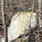
We continue our Iroquoia section End-2-End series which we began in the Fall of 2025. Any capable hikers are welcome regardless if completing the End-2-End for one of the badges or not. Hikers can expect rocky portions and hills as the trail goes up and down the Niagara escarpment. The trail may be wet and muddy. We hope to maintain a steady pace of 4 km/hr. We resume whre we left off at Sydenham Lookout in Dundas. After 2,1/2 km we pass Rock Chapel Sanctuary and Borer’s Falls. We descend to Valey Road (4 km). After an asecent we continue along the escarpment to Old Guelph Rd/Hwy 6 (6 km). We continue through the Hwy 6 tunnel through Clappison Woods. and the steep ascent through Smokey Hollow to the Great Falls Lookout Point (12 km) where there will be an optional dropout. We continue another 2 km to King Road (14 km). We will reward our efforts with a refreshment stop in Waterdown, home of the Copper Kettle’s apple fritters. The distance may be modified according to our progress during the day.