Join us for a hike! Registration required:
All hikes available to BTC members. Some hikes are open to non-members.
TIP: The calendar view displays up to 7 hikes on a day, but often there are more. Click “More events” to see them all.
Toronto Hike Schedule
Toronto Bruce Trail Club Registration Live Dates
Day Winter Coach Program
Registration begins two weeks in advance of the event departure (at 8:00 PM)
Day Bus Hikes
Registration begins two weeks in advance of the event departure (at 8:00 PM) with some exceptions of special event hikes
Day Coach Hikes
Registration begins 7 weeks in advance of the event departure
Day Car Hikes and Urban Hikes
Registration begins two weeks in advance of the event departure
Overnight and Weekend Trips
Registration begins 12 weeks in advance of the event departure
To view all Bruce Trail Conservancy Hikes click here
- 09November 9, 2025
Car Hike: Jefferson Forest and Bond Lake (Richmond Hill)
https://hikes.brucetrail.org/event/car-hike-jefferson-forest-and-bond-lake-richmond-hill-8/Sorry, the registration cut-off time for this hike has been reached.Not a member? Click here to join today!Hosting Club: Toronto
Category: Car Hike
Location (Google Maps):1245 Bethesda Side Rd, Richmond Hill, ON L4E 1A2 ( Bethesda Trail Head Parking lot)
Hike Leader(s): Amir Alemohammad Click here to contact Hike Leader(s)
Pace: Moderate (3-4 km/hr)
Terrain: Flat, Hilly, Level 2 (Intermediate – some hills and uneven surfaces, rocks and roots underfoot), Variable
Distance: 13-14 kmDescription
Join us for a wonderful hike in Jefferson Forest and have a snack/lunch beside the Bond Lake. We will hike among tall trees and bushes of the Jefferson Forest and across the Bayview-Yonge corridor to reach to the Bond Lake. Boots mandatory, poles recommended, bring at least 2L of water, sunscreen, snack/lunch and dress according to the weather conditions. Please avoid parking along the road. Difficulty Level: 2 (Moderate).Please arrive @7:45 AM for start of 8:00AM.
This is a joint hike with the Oak Ridges Trail Association (ORTA).
GO Train Hike: Stoney Creek City Park Trails To Battlefield Park and Devil's Punchbowl
https://hikes.brucetrail.org/event/go-train-hike-stoney-creek-city-park-trails-to-battlefield-park-and-devils-punchbowl/Sorry, the registration cut-off time for this hike has been reached.Not a member? Click here to join today!Hosting Club: Toronto
Category: GO Train Hike
Location (Google Maps): We will take the Niagara bound Express GO Train departing Union Station in Toronto departing at 9:04 AM arriving at Confederation GO Station in Stoney Creek at 10:30 AM. Meet us in the Great Hall of Union Station by the information desk over it by 8:50 AM or proceed to the Bay Street Concourse to board the train and you may find us in the accessibility coach (or find us when the train arrives at Confederation GO Station). On the return we will take the HSR Bus to return to Confederation GO and will be taking the GO Bus to Burlington to connect with the train (there’s no trains until 5:00 PM)Hike Leader(s): Tom Swales Click here to contact Hike Leader(s)
Pace: Moderate (3-4 km/hr)
Terrain: Hilly, Level 2 (Intermediate – some hills and uneven surfaces, rocks and roots underfoot), Variable
Distance: 10-11 kmDescription
We will take the Niagara bound express train from Union Station to Confederation GO Station in Stoney Creek (stops at Exhibition and Port Credit) and make our way towards the Niagara Escarpment by way of the local park trails to Battlefield Park (home of the historic pivotol battle of June 6 1813) connecting to the Bruce Trail, Devil’s Punchbowl Side Trail, and the Devil’s Punchbowl Conservation Area Lookout. We will retrace our steps to Battlefield Park and take an HSR Bus to return to Confederation GO Station. While most of the terrain will be easy (Level 1) we will be ascending and descending the escarpment on the Devil’s Punchbowl Side Trail (about 94 metres) and hiking boots are recommended. Optional pub stop at Shoeless Joe’s by the GO Station. The return trip will involve taking a GO Bus direct to Burlington Station to connect with trains that run half hourly (making all regular stops). Anyone is welcome to join from GO stops on the way or meet us at 10:30 at Confederation GO Station. - 10November 10, 2025No events
- 11November 11, 2025
Urban Walk: Valley View Park Thornhill
https://hikes.brucetrail.org/event/urban-walk-valley-view-park-thornhill-116/Sorry, the registration cut-off time for this hike has been reached.Not a member? Click here to join today!Hosting Club: Toronto
Location (Google Maps): Parking lot is off Sycamore Drive East of Bayview , across Starbucks plaza
Bus 91 from Finch east station stops at Sycamore station.Hike Leader(s): Mohammad Aghamiri Click here to contact Hike Leader(s)
Pace: Moderate (3-4 km/hr)
Terrain: Hilly, Level 2 (Intermediate – some hills and uneven surfaces, rocks and roots underfoot)
Distance: 7-8 kmDescription
We will explore Valleyview and Maple View parks, and walk along German Mill Creak, in return we stop in Huntington park and have snack under beautiful shed ,Even it is considered Urban walk, it is urban hike as we have some up and down hills and tree roots, please bring your hiking poles, water and snacks,
phone number for the day of hike 289 588 6482
- 12November 12, 2025No events
- 13November 13, 2025
Urban Walk: Valley View Park Thornhill
https://hikes.brucetrail.org/event/urban-walk-valley-view-park-thornhill-117/Sorry, the registration cut-off time for this hike has been reached.Not a member? Click here to join today!Hosting Club: Toronto
Location (Google Maps): Parking lot is off Sycamore Drive East of Bayview , across Starbucks plaza
Bus 91 from Finch east station stops at Sycamore station.Hike Leader(s): Mohammad Aghamiri Click here to contact Hike Leader(s)
Pace: Moderate (3-4 km/hr)
Terrain: Hilly, Level 2 (Intermediate – some hills and uneven surfaces, rocks and roots underfoot)
Distance: 7-8 kmDescription
We will explore Valleyview and Maple View parks, and walk along German Mill Creak, in return we stop in Huntington park and have snack under beautiful shed ,Even it is considered Urban walk, it is urban hike as we have some up and down hills and tree roots, please bring your hiking poles, water and snacks,
phone number for the day of hike 289 588 6482
- 14November 14, 2025
City Of Waterfalls.
https://hikes.brucetrail.org/event/city-of-waterfalls/Sorry, the registration cut-off time for this hike has been reached.Not a member? Click here to join today!Hike open to BTC Members only.
This is a Multi-Day Hike
You are signing up for the following dates and times:
2025-11-14 at 08:30
2025-11-16 at 08:30Hosting Club: Toronto
Category: Car Hike
Location (Google Maps): Cityview Park Main Lot coordinates 43.351747,-79.862195 maps 8,9Hike Leader(s): Smadar Junkin Click here to contact Hike Leader(s)
Pace: Brisk (4-5 km/hr)
Terrain: Challenging, Hilly, Level 2 (Intermediate – some hills and uneven surfaces, rocks and roots underfoot)
Distance: 21.3 kmsDescription
This hike series of 2 hikes will take us through the beautiful water falls of Hamilton. On the first day we will shuttle to Tews Falls+ Dundas Peak Parking. There is a parking fees of $11 to be shared between the hikers. We will go through Tews falls, Borer’s Falls, Great Falls. Other highlights- Dundas Lookout, Sydenham Lookout, Grindstone Creek, McNally Reserve Donor Wall.on November 16 we will meet at Mud Street Side Trail Parking coordinates 43.200682, -79.815214 maps 7, 8
we will shuttle to Artaban Road Parking coordinates, fees of $11 per car to be shared between the hikers.
we will go through Sherman Falls, Tiffany Falls, Lower Cheroke Falls, Upper Princess Falls, Mountview Falls, Sanatorium Falls, Albion Falls, Buttermilk Falls,
other highlights- Hamilton Cityscape, Stairs, Hamilton Branford Rail Trail
please arrive 15 minutes early so we can start the shuttle by 8:30. Bring food, 2 litres of water. Everyone is expected to participate in the shattle.
- 15November 15, 2025
Car Hike: Happy Valley King City
https://hikes.brucetrail.org/event/car-hike-happy-valley-king-city-7/Sorry, the registration cut-off time for this hike has been reached.Not a member? Click here to join today!Hosting Club: Toronto
Category: Car Hike
Location (Google Maps): Happy Valley, Oak Ridges Trail 16th Sideroad & Weston RoadPlease park along 16th Side road
Hike Leader(s): Mohammad Aghamiri Click here to contact Hike Leader(s)
Pace: Moderate (3-4 km/hr)
Terrain: Hilly, Level 2 (Intermediate – some hills and uneven surfaces, rocks and roots underfoot)
Distance: 12-14 kmDescription
Come and join us to view nice scenery and look out of Happy valley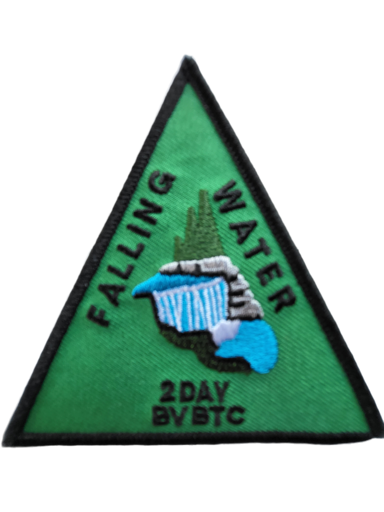
Did someone say badge?!! Two-Day Falling Water Badge - School Bus Hike (#1 of 2)
https://hikes.brucetrail.org/event/did-someone-say-badge-two-day-falling-water-badge-school-bus-hike/Sorry, the registration cut-off time for this hike has been reached.Not a member? Click here to join today!Trip Information
Departure Time: 08:30
Return to City Time: 18:30
Departure Point: Kipling Departure PointOptional Items
Badge (optional) - Members ($10)
Badge (optional) - Non-members ($15)Hosting Club: Toronto
Category: Bus Hike
Location (Google Maps): Beaver Valley Ski ClubHike Leader(s): Marijo Roy, Felix Wan Click here to contact Hike Leader(s)
Pace: Moderate (3-4 km/hr)
Terrain: Challenging, Level 2 (Intermediate – some hills and uneven surfaces, rocks and roots underfoot)
Distance: 30 km over two SaturdaysDescription
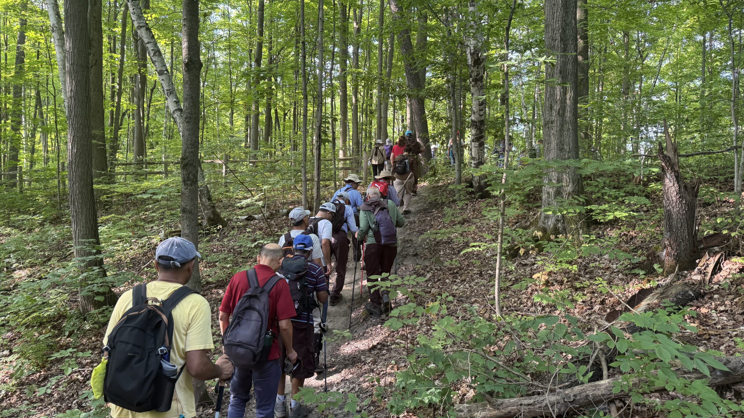
Please join us for a series of two 15 km hikes to earn the Two-Day Falling Water badge. These beautiful hikes will take us on both the east and west sides of the Beaver Valley. The Falling Water section includes some challenging parts, with plenty of ups and downs and several steep sections. Those who complete the entire loop will receive the Two-Day Falling Water Triangle badge. The fee ($10.00 for members; $15.00 for non-members) will be collected on the bus at the start of Hike #2 for those who opt to obtain the badge.Hike #1 of 2 (BT Map #26) – Today, we’ll hike east on the Valley Crossover Side Trail, then south to Hogg’s Falls, reaching km 65.2.
A late return to Kipling Station is expected.
Reminders:
1. Wear sturdy footwear and appropriate attire for the weather and the terrain (snow might be present).
2. Hiking poles are a good idea in any season, especially when the terrain is rocky or slippery.
3. Always carry I.D. and your health card.
4. Bring lunch, sufficient water, and snacks. A minimum of 2L of water is recommended.
5. Bring your own first aid kit.Looking forward to hiking with you,
Marijo and Felix
#1/3 Toronto E2E & in Memory of Doug Sloan - 18KM
https://hikes.brucetrail.org/event/hike-in-memory-of-doug-sloan-from-speyside-to-kelso-18km/Sorry, the registration cut-off time for this hike has been reached.Not a member? Click here to join today!Hosting Club: Toronto
Category: Car Hike
Location (Google Maps): KM121.3. Kelso Conservation AreaHike Leader(s): Alina Lin
Pace: Brisk (4-5 km/hr)
Terrain: Challenging, Hilly, Level 2 (Intermediate – some hills and uneven surfaces, rocks and roots underfoot), Rocky, Variable
Distance: 19 kmDescription
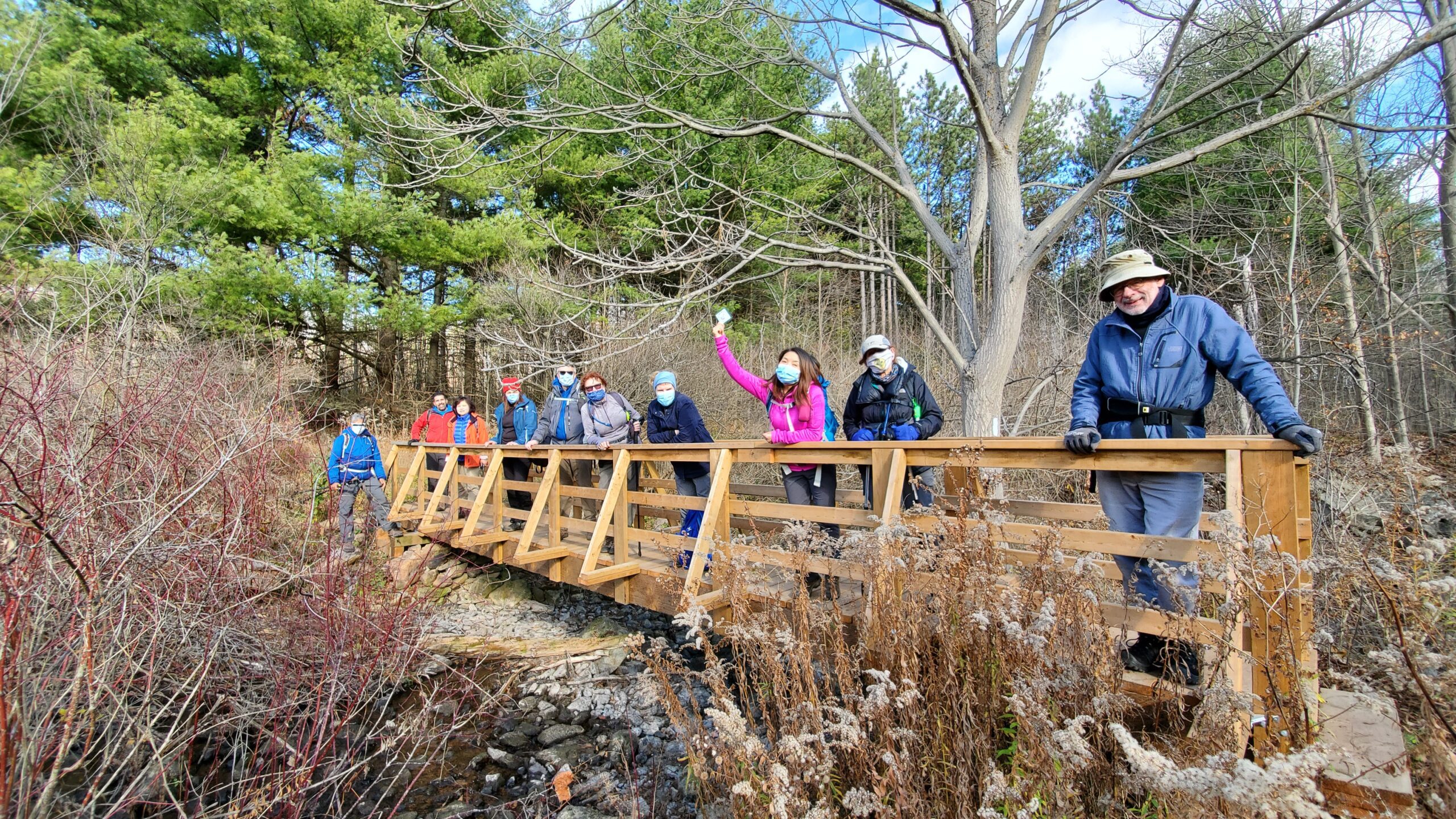
If you have been a member of the Bruce Trail community long enough, you might have heard of Doug Sloan, a legendary hiker who completed the Bruce Trail End-to-End more than 50 times—he actually achieved his 50th completion in 2015 and stopped counting afterward, though he continued hiking until he passed away in December 2021. As an avid hiker, committed Hike Leader and Trail Captain, and passionate supporter of the Bruce Trail, Doug made countless friends on the trail and inspired many with his remarkable dedication and accomplishments. In May 2024, a plaque “The Doug Sloan Wetland” was unveiled in Speyside to honour his contributions and achievements.My last hike with Doug was on November 14, 2020, when he joined the final hike of a Toronto Section double-badge End-to-End series I led, during which he presented badges to qualifying hikers. That hike took place between Kelso Conservation Area and Speyside.
It feels fitting that my current End-to-End journey brings me back to the same area around the same time of year. On November 15, 2025, I am leading a hike from Speyside to Kelso Conservation Area and making it a hike in memory of Doug Sloan. Our hike will start at Speyside, where Doug’s commemorative plaque stands, and end at Kelso, where this group photo was taken back on November14, 2020.
Meeting Point:
Kelso Conservation Area parking lot. Enter from Tremaine Rd between Steeles Ave nd Highway401. GPS: 43.503204, -79.947548. Entrance fee applies at Kelso Conservation Area, see details at https://www.conservationhalton.ca/park-fees-membership-rates/ Please arrive at the parking lot before 8:45am to allow time for car shuttle coordination.We will car shuttle to Toronto Section KM14.1. 17th side road, GPS: 43.592859,-79.980456. From there to hike back to Kelso Conservation Area.
All drivers are expected to participate in the car shuttle, either before or after the hike. All hikers are expected to chip in for parking fees, if applicable.
Important Notes:
- Wear sturdy hiking footwear and dress appropriately for the weather
- Bring snacks, and at least 1.5L of water
- No dropouts available.
- No pets.