|
Sun | Mon | Tue | Wed | Thu | Fri | Sat |
|---|
July | July | July | July | 1 | 2 | 3  Car Hike: Erindale Park Mississauga Car Hike: Erindale Park Mississauga 8:30 AM-1:15 PM 08/03/2024 https://hikes.brucetrail.org/event/car-hike-erindale-park-mississauga-2/2024-08-03/   Bus Hike: Hiking, swimming, and attending the annual Kempenfest in Barrie Bus Hike: Hiking, swimming, and attending the annual Kempenfest in Barrie 8:30 AM-6:00 PM 08/03/2024 https://hikes.brucetrail.org/event/bus-hike-hiking-swimming-and-attending-the-annual-kempenfest-in-barrie/2024-08-03/ 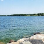 Trip Information
Departure Time: 08:30
Return to City Time: 18:00
Departure Point: York Mills Bus Pickup Click here for more information or to register Optional Items
Hosting Club: Toronto
Category: Bus Hike
Location (Google Maps): Centennial Park – Oro-Medonte Trail (Barrie) Hike Leader(s): Edmond Brown; Marijo Roy Click here to contact Hike Leader(s) Pace: Leisurely
Terrain: Flat
Distance: 12 km Description
Please join us on Saturday, August 3rd, for a wonderful day of hiking, swimming, and attending the annual Kempenfest, one of North America’s largest outdoor arts, crafts, and music festivals! We will hike along the Oro-Medonte Trail and onto Barrie, where you’ll have time to visit the annual Kemperfest, featuring over 400 vendors, one-of-a-kind arts and crafts, antiques, and food vendors. You may also choose to swim at Centennial Beach, sightseeing in Barrie’s downtown area, or enjoy a drink at one of the patios overlooking Barrie’s beautiful waterfront. Sign up today! https://kempenfest.com/festival/
|
4 | 5 - Toronto E2E (shuttle)
8:30 AM-1:30 PM 08/05/2024 https://hikes.brucetrail.org/event/toronto-e2e-shuttle/2024-08-05/ This is a Multi-Day HikeYou are signing up for the following dates and times:
2024-08-05 at 08:30
2024-08-12 at 08:30
2024-08-19 at 08:30 Click here for more information or to register Hosting Club: Toronto, Caledon Hills
Category: End-to-End
Location (Google Maps): Meet at Fourth Line (where the trail crosses) (Bruce Trail Ref. Guide km 17.4)
Shuttle to Hilton Falls (paid parking) Hike Leader(s): Heather Murch Click here to contact Hike Leader(s) Pace: Brisk – 4 to 5 km/hour
Terrain: Moderate – some hills and/or some poor footing
Distance: 17.6 km Description
You are signing up for 3 hikes. Please arrive at the meeting point ready to shuttle by 8:30. We will shuttle south and hike north. Everyone will need to shuttle; have your vehicle ready to take 4 people if possible. Come prepared for… Hiking! You must wear hiking shoes/boots. Consider bringing hiking poles for uneven terrain. Heat: At least 2L of water; a sun hat. Rain: A raincoat/poncho and a love of the outdoors, no matter the weather. Bugs: Bug spray or a bug hat/shirt. Poison Ivy: Long sleeves; long pants. An appetite: Bring a snack; we’ll take a short break along the way. Although I have hiked the full Bruce Trail a few times, this is my first official hike series as a leader, so, Welcome! 🙂 5 Aug. 17.6 km Meet at Fourth Line (where the trail crosses) (guide 17.4)
43.615163, -79.975157 Shuttle to Hilton Falls (paid parking)
43.505705, -79.961589 12 Aug. 16.9 km
Meet at
8th Line & 27 Sideroad (Guide approx. km 34.3)
43.686276, -79.975578 Shuttle to:
Fourth Line (where the trail crosses)
43.615163, -79.975157 19 Aug (total 16 km)
1. 2.5 km
Meet at:
Boston Mills Road (Guide 48 km)
43.750866, -79.951452 Modified shuttle to Creditview Road
43.767739, -79.942929 2. 13.5 km Shuttle to:
8th Line & 27 Sideroad (Guide approx. km 34.3)
43.686276, -79.975578
| 6 - Peninsula Stained Glass Badge, Fundraiser in 8 hikes.
9:00 AM-3:00 PM 08/06/2024 https://hikes.brucetrail.org/event/peninsula-stain-glass-badge-fundraiser/2024-08-06/ 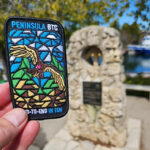 Hike open to BTC Members only. This is a Multi-Day HikeYou are signing up for the following dates and times:
2024-08-06 at 09:00
2024-08-07 at 08:30
2024-08-08 at 08:30
2024-08-09 at 08:30
2024-08-19 at 09:00
2024-08-20 at 08:30
2024-08-21 at 08:30
2024-08-22 at 08:30 Click here for more information or to register Hosting Club: Toronto, Peninsula
Category: Car Hike
Location (Google Maps): BlueWater park, Wiarton, km 0.0 coordinates N 44.742514,W 81.135140 map 35 Hike Leader(s): Smadar Junkin Click here to contact Hike Leader(s) Pace: Brisk
Terrain: Challenging, Variable
Distance: 24.4 km Description
Thank you for registering to the Stain Glass, fund raising hike of the Peninsula. This will be a fundraising hike series in 8. Each hiker will be allowed to miss one hike and make it on their. The funds for this hike will be collected by the Toronto club and it will be transferred to the Peninsula club to help maintain the trail and keep the pledge of Ribbon Of Wilderness For Everyone, Forever.
on the first hike we will shuttle to km and hike back.
hike 2- we will meet at km 44.1, Hope Bay coordinates N 44.902930,W 81.155706 map 37 and shuttle to km 24.4 hike 3- we will meet at km 44.1, Hope Bay and will shuttle to km 67.9 and walk back. hike 4- we will meet at km 87.5, Richardson Side Trail, coordinates N 45.020460,W 81.283790 map 39, we will shuttle to km 67.9 and walk back.
hike 5- we will meet at Richardson SideTrail and shuttle to km 110.6 – (may be a paid parking) and walk back. hike 6- we will meet at km 110.6 coordinates N 45.147416,W 81.338921 map 40, we will shuttle to km 125.4 Crane Lake and walk back. hike 7- we will meet at Crane Lake, km 124.4 coordinates N 45.190813,W 81.419658, map 41 we will shuttle to Cyprus Lake, parking B. this is a paid parking and will add about 2km to the hike. We will go on the trail that leads to mars lake, km 145.5 and walk back. hike 8- we will park in Tobermory, there are some places that are free parking, we will park in a free parking place that I will explain how to get there during the duration of the hike. We will shuttle to cypress Lake, ( paid parking) and walk back. It’s badge day at the cairn, pictures and treats.
please bring 2 or more litres of water, snacks and lunch. Everyone is expected to participate in the shuttle once or twice in the duration of the 8 days. lets go and have fun on the trail.
| 7 - Car Hike: Midweek Fitness Walk Around Island Lake (8.5 km)
10:15 AM-1:15 PM 08/07/2024 https://hikes.brucetrail.org/event/car-hike-midweek-fitness-walk-around-island-lake-8-5-km/2024-08-07/ Click here for more information or to register Hosting Club: Toronto
Category: Car Hike
Location (Google Maps): Island Lake Conservation Area (Hwy 10 and 4th Ave intersection) Hike Leader(s): Natalia Svechnikova Click here to contact Hike Leader(s) Pace: Moderate
Terrain: Flat
Distance: 8.3 km Description
Please join me for an enjoyable fitness walk on a relatively flat and easy trail around the lake in the Island Lake Conservation area. The trail has treed sections as well as boardwalks near the water, meadows with beautiful flowers and much more. We will keep some steady but still comfortable pace of approximately 3 km/h. We will have a short break on the picnic area after about 6 km. Please bring 2 L of water, sunglasses, hut and some snacks/light lunch. We will meet at the start of the trail (near the large trail map) at 4th Ave and Hwy 10 intersection. You can park anywhere at the Zehrs Orangeville, Winners or Mark’s parking lot which is just across Hwy 10,
| 8 | 9 | 10  Urban Walk: Hendrie Valley Sanctuary to West Harbour GO Station, Hamilton Urban Walk: Hendrie Valley Sanctuary to West Harbour GO Station, Hamilton 8:30 AM-2:15 PM 08/10/2024 https://hikes.brucetrail.org/event/urban-walk-hendrie-valley-sanctuary-to-west-harbour-go-station-hamilton-2/2024-08-10/ Click here for more information or to register Hosting Club: Toronto
Category: Urban Walk
Location (Google Maps): Meet in the Great Hall of Union Station by the information desk with the clock with no later than 8:30 AM to take the Lakeshore West train towards West Harbour departing at 8:45 AM Hike Leader(s): Tom Swales, Janet McColeman Click here to contact Hike Leader(s) Pace: Moderate (3-4 km/hr) Distance: 12 km Description
From Aldershot GO Station we will hike to scenic Hidden Valley Park and the Hendrie Valley Sanctuary, a popular spot for birdlife. Then on to Burlington Heights and the Hamilton Waterfront Trail to catch the train back to Toronto from the West Harbour GO Station. Optional drop out at Burlington Heights by taking the local bus to Burlington GO Station. Optional pub stop at Fisher’s Pier 4 pub 10 minutes walk Harbour GO Station. We will hike from Aldershot GO Station in Burlington to West Harbour Station in Hamilton via Hidden Valley Park, Hendrie Valley (RBG), Burlington Heights, and the Hamilton Waterfront Trail. The route is mostly flat with the exception of one hill to reach Burlington Heights to connect with the Waterfront Trail. Hendrie Valley features a lovely boardwalk through the wetlands. The total distance is about 12 km and we will walk at an average pace of 3 to 3.5 km per hour (and less than 4.). We will take the train departing Union Station at 8:44 and arriving at Aldershot at 9:55. You may meet Tom in the Great Hall by the information desk with the clock over it to depart by 8:30 or find us in the upper level of the accessibility coach if boarding at a station on the way. The train will stop at Mimico Station at 9:00 and Port Credit Station at 9:13. Trains depart West Harbour Station hourly at 23 minutes past the hour. There will be an optional pub stop 10 minutes walk from the station. Ice cream is also available at Hutches fish and chips next to the GO station. Arrival at West Harbour is expected to be approximately just after 2:00 PM. If you have a cell phone with data you may purchase the $10 day pass at the link below. Make sure to select Weekend Day Pass and not an E-Ticket. The senior return fare from Union is less than $11.00 so with the “One Fare” program covering the TTC ride to the GO station it’s cheaper for seniors to use their Presto Card. https://tickets.gotransit.com/en-us?start_address=UN&end_address=WR&ticket_adult=1&ticket_senior=0&mode=one_way
- Car Hike: Glasgow Village (Uxbridge)
8:30 AM-1:15 PM 08/10/2024 https://hikes.brucetrail.org/event/car-hike-glasgow-village-uxbridge/2024-08-10/ Click here for more information or to register Hosting Club: Toronto
Category: Car Hike
Location (Google Maps): Glasgow Trail, Concession Road 2 Park in parking lot at the trail head. From Highway 404 turn right to Stouffville Rd, till to the end of road and turn left on York Durham line in About 1km turn right to Webb Rd. and turn right to Concession Road 2 ,you will see parking lot in 500 meters Hike Leader(s): Mohammad Aghamiri Click here to contact Hike Leader(s) Pace: Moderate (3-4 km/hr)
Terrain: Variable
Distance: 14-17 km Description
Lets explore Goodwood conservation area and visit Secord forest and pond Approximately 5-hour hike, bring lots of water and protect yourself from mosquitos Some safety procedures during the hike: 1-Hikers must stay between the leader and the sweep. 2-Hikers must advise the leader or the sweep if they wish to leave the group. 3- Hikers must follow the whistle instructions: 1 blast- stay where you are; 2 blasts come to the leader; 3 blasts – come to the leader quickly. 4-Hike leader may request volunteers to stop at trail intersections, they need to help hikers to the direction the group walk and wait till they see the sweep . 5-Hikers have to make sure they can see the persons behind and in front of them.
- Bus Hike: Pathways To Port Dover Lynn Valley Trail – Cancelled Due To Low Registration
8:30 AM-7:00 PM 08/10/2024 https://hikes.brucetrail.org/event/bus-hike-pathways-to-port-dover-lynn-valley-trail-2/2024-08-10/ Click here for more information or to register Hosting Club: Toronto
Category: Cancelled
Location (Google Maps): Lynn Valley Trail Hike Leader(s): Tom Swales, Janet McColeman Click here to contact Hike Leader(s) Pace: Moderate
Terrain: Flat
Distance: 12 km Description
Join us for a scenic and easy paced walk, a regular summer favorite led by Wayne Crockett, along the trails running through Norfolk County ending at historic Port Dover. The route is primarily on rail trails so is ideal for those who favor a flatter and easier route in the summer heat. Dropout at 8km. After the walk there will be the opportunity to indulge in the local perch fish and chips or hang out at the beach which together make Port Dover famous. Long Distance Bus Fare applies and there will be a late return (after 6:00 Pm).
- Urban Walk; Historic Main Street Unionville & Main Street Markham & Rouge Valley Trail
2:00 PM-9:00 PM 08/10/2024 https://hikes.brucetrail.org/event/urban-walk-historic-main-street-unionville-main-street-markham-rouge-valley-trail/2024-08-10/  Click here for more information or to register Hosting Club: Toronto
Category: Urban Walk
Location (Google Maps): Main Street Unionville, Main Street Markham, Milne Dam Conservation Area, Rouge Valley Trail Hike Leader(s): Celia Ho Click here to contact Hike Leader(s) Pace: Moderate
Terrain: Flat
Distance: 14.15 km Description
Visit the old villages of Unionville and Markham Village and part of the Rouge Valley Trail system in the City of Markham. We will meet at Varley Art Gallery of Markham in Main Street Unionville after the art event from 2:00 PM – 4:00 PM: https://visitmarkham.ca/event/curators-corner-discovering-art-together/ If you are not planning to join the event at the gallery, the meeting time for the walk is 4:00 PM at the entrance outside the gallery. We will walk along the loop at Too Good Pond before heading to Bruce Creek, Austin Park, and Milne Dam Conservation Area along the Rouge Valley Trail, arriving at Main Street Markham. From this point on it will be road walking as we head back to Main Street Unionville. Drop-out points are available along the way with access to public transit and passing by Markham GO Station and Centennial GO Station. Arriving in Main Street Unionville in the evening hours, there is the option to return home or have a walk on Main Street Unionville and/or have a refreshment stop. (https://unionville.ca/) Please refer to the route map: https://onthegomap.com/s/t3o2m013
|
11 | 12 - Loop Hike #2 – Speyside
8:30 AM-1:30 AM 08/12/2024 https://hikes.brucetrail.org/event/loop-hike-2-speyside/2024-08-12/  Click here for more information or to register Hosting Club: Iroquoia, Toronto
Category: General Hike
Location (Google Maps): Pear Tree Park & Bruce Trail Parking, 15 Side Road Hike Leader(s): Pati Greenwood, Jeff Dowsett Click here to contact Hike Leader(s) Pace: Medium – 3 to 4 km/hr
Terrain: Moderate – Some hills and/or some poor footing
Distance: 14K Description
We will hike the main trail and side trails for 14K loop. We will meet at the Bruce Trail Pear Tree Parking Lot on 15 Sideroad, 200 m southwest of Halton Road 25. Bring plenty of water and a snack. Please arrive by 8:15 am as we will leave promptly at 8:30 am.
| 13 | 14 | 15 | 16 | 17 - Bethesda Trail Richmond Hill
8:30 AM-1:30 PM 08/17/2024 https://hikes.brucetrail.org/event/car-hike-bethesda-trail-richmond-hill-20/2024-08-17/ Click here for more information or to register Hosting Club: Toronto
Category: Urban Walk
Location (Google Maps): Meet at Bethesda Trail Head Parking on Bethesda Sideroad off Bayview Avenue, across from Lake Wilcox. This parking lot is free.
From Finch subway station take blue bus to Richmond hill Centre and then Bus 91B to Bethesda Sideroad and then walk 600 meter to parking lot and meeting point, Please check the public transit one day before hike. Hike Leader(s): Mohammad Aghamiri Click here to contact Hike Leader(s) Pace: Moderate (3-4 km/hr)
Terrain: Hilly, Variable
Distance: 14-15 km Description
Join us to explore Jefferson Forest and Bond lake Please bring hiking poles, proper closing and shoes and lots of water, Please carefully read safety procedures during the hike: 1-Hikers must stay between the leader and the sweep. 2-Hikers must advise the leader or the sweep if they wish to leave the group. 3- Hikers must follow the whistle instructions: 1 blast- stay where you are; 2 blasts come to the leader; 3 blasts – come to the leader quickly. 4-Hike leader may request volunteers to stop at trail intersections, they need to help hikers to the direction the group walk and wait till they see the sweep . 5-Hikers have to make sure they can see the persons behind and in front of
- Falls to Falls
8:30 AM-2:00 PM 08/17/2024 https://hikes.brucetrail.org/event/borer-falls-to-the-great-falls-at-smokey-hollow-thru-grindstone-creek/2024-08-17/ 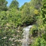 Click here for more information or to register Hosting Club: Iroquoia, Toronto
Category: Car Hike
Location (Google Maps): Parking area beside Mill St at the Smokey Hollow Side Trail. GPS Coordinates N43.330803, W79.886980 Hike Leader(s): Ross Estrella Click here to contact Hike Leader(s) Pace: Moderate (3-4 km/hr)
Terrain: Hilly, Rocky, Variable
Distance: 12.5 kms Description
At a moderate to brisk pace we’ll hike from Borer’s Falls to the Great Falls at Smokey Hollow while enjoying the rhythmic and calming sound of Grindstone Creek rushing water. Please bring snack, lunch and sufficient water for hydration. Bring sun screen, sun head protection and bug spray in the event our friendly mosquitoes welcome us. Comfortable hiking shoe/boot and poles are strongly suggested. Please dress accordingly to weather forecast for the area. Please make sure your personal medication and health card is with you at all times. No drop out.
- Bus Hike: Niagara, beyond the Falls
9:00 AM-6:00 PM 08/17/2024 https://hikes.brucetrail.org/event/niagara-beyond-the-falls/2024-08-17/  Click here for more information or to register Hosting Club: Toronto
Category: School Bus Hike
Location (Google Maps): Niagara Parks Hike Leader(s): Marijo Roy; Janet McColeman Click here to contact Hike Leader(s) Pace: Leisurely (2-3 km/hr)
Terrain: Flat, Variable
Distance: 10 km Description - Please join us for a relaxing and picturesque hike along the Niagara River Recreation Trail. Along the way, we’ll explore the Botanical Gardens, which boasts 99 acres of meticulously maintained gardens, including a world-famous rose garden, the Niagara Glen Nature Centre, and the Whirlpool Area, among other places. As we navigate the trails, we will take in the Niagara River’s breathtaking views and its powerful rapids. There will be time for picture-taking and learning about Niagara’s history and ecology. We’ll follow the scenic Niagara River to Downtown Niagara, stopping for refreshments after the hike.
Trip Information:
Departure Time: 9:00 a.m.
Return to City Time: 6:00 p.m.
Departure Point: Kipling Station North Parking Lot https://maps.app.goo.gl/pudZxLwvbcjR9vLq8
|
18 - Urban Walk: G Ross Lord Park
10:30 AM-1:30 PM 08/18/2024 https://hikes.brucetrail.org/event/urban-walk-g-ross-lord-park/2024-08-18/ 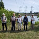 Click here for more information or to register Hosting Club: Toronto
Category: Urban Walk
Location (Google Maps): G. Ross Lord Park Hike Leader(s): Brian Rideout Click here to contact Hike Leader(s) Pace: Moderate
Terrain: Flat
Distance: 8.5 km Description
Please meet be by 10:30 am (by the bus stop) in the parking lot of the plaza on the south east corner of Steeles Ave West and Dufferin St. We will hike south through G Ross Lord Park, returning to Steeles for an estimated distance of 8.5 km. The pub stop is Montana’s on Steeles west of Dufferin for those who wish to join me. Bring a snack, 2 liters of water, bug spray and sun screen. Here is an online map of our route G Ross Lord Park Note: Registration closes 48 hours before the start of the hike.
| 19 | 20 | 21 - Car Hike: Midweek Fitness Hike in the Forks of the Credit Provincial Park (ca 10 km)
10:30 AM-2:30 PM 08/21/2024 https://hikes.brucetrail.org/event/car-hike-midweek-fitness-hike-in-the-forks-of-the-credit-provincial-park-ca-10-km/2024-08-21/ Click here for more information or to register Hosting Club: Toronto
Category: Car Hike
Location (Google Maps): Forks of the Credit Provincial Park (McLaren Road entrance) Hike Leader(s): Natalia Svechnikova Click here to contact Hike Leader(s) Pace: Moderate
Terrain: Hilly, Variable
Distance: ca 10 km Description
Please join me for an enjoyable fitness hike on a hilly part of the park. We will hike a 10 km loop with one section going up hill. The trail has mostly treed sections as well as a few open areas. There will be a lunch stop near the Credit River. Be prepared wearing comfortable cloths, hiking shoes/boots. Please bring at least 2 L of water, a light lunch/snacks, sun screen and bug spray optional. We will on the parking lot at the trail head and map poster to the right of the washroom facilities. You have to drive to the main entrance on the McLaren Road and pay for the parking.
| 22 | 23 | 24 - Car Hike: Boyd Conservation Park Vaughan
8:30 AM-1:15 PM 08/24/2024 https://hikes.brucetrail.org/event/car-hike-boyd-conservation-park-vaughan-5/2024-08-24/ Click here for more information or to register Hosting Club: Toronto
Category: Urban Walk
Location (Google Maps): Boyd Conservation Park, Islington Avenue, Vaughan, ON free parking at the entrance of the park, There are different public transit routes to this parking lot please check transit maps/google map Hike Leader(s): Mohammad Aghamiri Click here to contact Hike Leader(s) Pace: Moderate
Terrain: Variable
Distance: 14-17 km Description
Explore the trails that wind through the beautiful valley at Boyd Conservation Area and the William Grainger Greenway. We will have lunch/snack in shelter with seated area, Please bring hiking poles, proper closing and shoes and lots of water, Please carefully read safety procedures during the hike: 1-Hikers must stay between the leader and the sweep. 2-Hikers must advise the leader or the sweep if they wish to leave the group. 3- Hikers must follow the whistle instructions: 1 blast- stay where you are; 2 blasts come to the leader; 3 blasts – come to the leader quickly. 4-Hike leader may request volunteers to stop at trail intersections, they need to help hikers to the direction the group walk and wait till they see the sweep . 5-Hikers have to make sure they can see the persons behind and in front of
- Bus Hike: Northern Rouge National Urban Park – Northeast Trail & Harvest Trail (Markham-Pickering-Whitchurch-Stouffville)
8:30 AM-5:00 PM 08/24/2024 https://hikes.brucetrail.org/event/bus-hike-northern-rouge-national-urban-park-northeast-trail-harvest-trail-markham-pickering-whitchurch-stouffville/2024-08-24/ 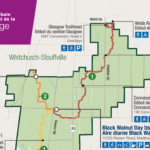 Trip Information
Departure Time: 08:30
Return to City Time: 17:00
Departure Point: York Mills Bus Pickup Click here for more information or to register Optional Items
Unionville GO Station Pick-up ($0.01)
Hosting Club: Toronto
Category: Bus Hike
Location (Google Maps): Northern Rouge National Urban Park Hike Leader(s): Celia Ho, Tom Swales Click here to contact Hike Leader(s) Pace: Moderate (3-4 km/hr)
Terrain: Flat
Distance: 15.8 km Description
On this hike we will continue to explore the Rouge National Urban Park, this time in the section of the park in Markham, Pickering, and Whitchurch-Stouffville, starting in the Black Walnut Day Use Area in Markham. We will explore the Northeast Trail (10.7 km) and the Harvest Trail (5.1 km). The meeting point will be the York Mills Bus Pickup location. There is an additional pickup location at Unionville GO Station – select that option when registering if you would like to be picked up there. The meeting time is 8:30 AM at the York Mills pickup location and 8:45 AM at the Unionville GO Station pickup location. This will be a relatively easy and leisurely hike. The terrain is relatively flat with some stairs. The surface condition consist of compacted granular trails and boardwalks. The pace will be a moderate pace of 4 km/hr. There will be a drop-out point at 10.7 km after the Northeast Trail. The total distance covering all the trails will be 15.8 km. After the hike there will be a refreshment stop at the Muddy York Brewery in Whitchurch-Stouffville or on Main Street Stouffville. For your reference, the Park Map for the Rouge can be found at: https://parks.canada.ca/pn-np/on/rouge/visit/cartes-maps
|
25 - Urban Walk; Markham Hike and Splash
9:30 AM-3:30 PM 08/25/2024 https://hikes.brucetrail.org/event/urban-walk-markham-hike-and-splash/2024-08-25/ 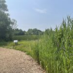 Click here for more information or to register Hosting Club: Toronto
Category: Urban Walk
Location (Google Maps): Finch Go Bus Terminal, Platform 2 Hike Leader(s): Leonora Rochwerger Click here to contact Hike Leader(s) Pace: Moderate
Terrain: Flat
Distance: 10 km (approx.) Description
Join us for a 10 km hike along the Rouge River, through sections of Austin Park and Milne Dam Conservation Park, and ending with a post-hike splash (optional- for those interested) at the Morgan Outdoor Pool in Markham Village. Route map: https://onthegomap.com/s/mfi28ji6 How to get there and get home: We will meet as a group no later than 09:30 at the Finch Go Bus Terminal, Platform 2 outside the TTC Finch Station. From there, we will use YRT public transport to get to our hiking starting point. If you are driving, meet us at the Stiver Mill Community Centre at 9 Station Ln, Markham, at approximately 10:45 am. There is free parking. Please contact the hike leader for precise meeting instructions. To go back, we will use YRT public transport buses to get to our starting points (either parking or TTC Finch Station). Alternatively, GO trains go from Markham Village GO Station to Union station. What to bring: Proper walking /hiking shoes, at least 2 litres of water, sunscreen, hat, bug repellent if used and a packed lunch. Appropriate clothing for the weather. No dogs allowed If going swimming, bring a swimming suit and towel. There is a fee of $4.60 + tax to enter the pool. Change rooms and showers are available. You will need to bring your own lock for a locker. For more information about the Morgan Pool visit: https://www.markham.ca/wps/portal/home/recreation/community-fitness-centres/morgan-outdoor-pool/morgan-pool
- Car Hike: Hike #8 to earn the Dufferin Hi-Land Youth and/or Side Trails Badge!
10:00 AM-2:00 PM 08/25/2024 https://hikes.brucetrail.org/event/car-hike-hike-8-to-earn-the-dufferin-hi-land-youth-and-or-side-trails-badge/2024-08-25/ 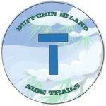 Click here for more information or to register Hosting Club: Toronto, Dufferin Hi-Land
Category: Car Hike
Location (Google Maps): We will meet at roadside parking on the west side of 2nd Line E, where the road ends a little north of 8 Sideroad (Map 20 of the Bruce Trail Reference Guide, Edition 31). Hike Leader(s): Monica Pasquali Click here to contact Hike Leader(s) Pace: Leisurely (2-3 km/hr)
Terrain: Variable
Distance: 7.4 km Description
Calling all families with children who love hiking and earning badges!!! This is the eighth in a series of ten hikes that will be offered throughout 2024 on a roughly monthly basis so that children who are 15 years of age and younger can earn the Dufferin Hi-Land Adventurer Youth Badge and their parents/guardians can earn the Dufferin Hi-Land Side Trails Badge at the same time!!! Details regarding the requirements for each badge can be found here: https://dufferinbrucetrailclub.org/dufferin-bruce-trail-club-badges/ Each of the ten hikes will be a loop hike so no car shuttles will be needed, and each hike will cover a distance of approximately 6-9 km hiked at a leisurely pace (2-3 km/h) so children and adults alike can participate. This eighth hike will be a summer hike to explore the following four side trails: 2nd Line ECL, part of the Oliver Creek ST, the Boyne Creek ST, and the Mulmur Lookout ST. Please dress appropriately for a summer hike by dressing in lightweight and breathable clothing, wearing a sunhat, and wearing comfortable footwear that has good traction. It is also advised that you bring sunscreen, bug spray, a light sweater, and suitable rain apparel in case conditions require their use. As well, make sure you bring enough water and food for a 3-4 hour hike since we’ll be covering a total distance of approximately 7.4 km. Hopefully you’ll be able to join me on Sunday, August 25th! Until then, happy hiking, everyone!
- Urban Walk: Bluffers Park
10:30 AM-1:00 PM 08/25/2024 https://hikes.brucetrail.org/event/urban-walk-bluffers-park-2/2024-08-25/  Click here for more information or to register Hosting Club: Toronto
Category: Urban Walk
Location (Google Maps): Toronto, Ontario Hike Leader(s): Brian Rideout Click here to contact Hike Leader(s) Pace: Moderate
Terrain: Flat
Distance: 6.9 km Description
Please join me at Kennedy Station on the bus platform by 9:45 am. We will take the 201 Bluffers Park bus departing 10:00 am, arriving 10:22 am. We will wander the trails of bluffers park for an estimated distance of 6.9 km. Pub stop is at the Dogfish Pub & Eatery in the park. Please bring at least 2 liters of water, a light snack, bug spray and sunscreen. Here is an online map of our route. Bluffers Park Note: Registration closes 48 hours before the start of the hike.
| 26 | 27 | 28 | 29 | 30 | 31 - Car Hike: Bethesda Trail Richmond Hill
8:30 AM-1:15 PM 08/31/2024 https://hikes.brucetrail.org/event/car-hike-bethesda-trail-richmond-hill-30/2024-08-31/ Click here for more information or to register Hosting Club: Toronto Location (Google Maps): Free parking lot at the head of trail Bethesda Side Road off Bayview Ave. across Wilcox lake Hike Leader(s): Mohammad Aghamiri Click here to contact Hike Leader(s) Pace: Moderate (3-4 km/hr)
Terrain: Hilly, Level 2 (Intermediate – some hills and uneven surfaces, rocks and roots underfoot)
Distance: 14-15 km Description
Join us to explore the trails of York Regional Forest and the Oak Ridges Corridor at Jefferson Forest and Bond lake, From parking lot we hike thought Jefferson forest and continue to Bond Lake and have snack beside the lake and return to parking around 13 to 13.30
- Bus Hike: Crawford Lake
8:30 AM-5:00 PM 08/31/2024 https://hikes.brucetrail.org/event/bus-hike-crawford-lake/2024-08-31/  Trip Information
Departure Time: 08:30
Return to City Time: 17:00
Departure Point: Kipling Departure Point Click here for more information or to register Optional Items
Hosting Club: Toronto
Category: Bus Hike
Location (Google Maps): Crawford Lake Hike Leader(s): Tim Wainwright, George Lennon, Felix Wan Click here to contact Hike Leader(s) Pace: Moderate (3-4 km/hr)
Terrain: Hilly, Other (Refer to Description)
Distance: 16.1 km Description
Our hike starts at the main Bruce Trail at Steeles and Appleby Rd, and continues through the Nassagaweya Canyon connecting Rattlesnake Point to the Crawford Lake Area. The area features majestic cliffs, rugged rock formations, and lush vegetation — a picturesque landscape that is ideal for nature lovers. Its cliffs provide a perfect habitat for turkey vultures to nest, and they can be seen circling overhead as our journey continues to Crawford Lake and its reconstructed 15th century Iroquoian village, where we’ll be stopping for lunch with time to explore the village if possible. Archaeological research has found 10,000 artifacts in the area. From there we’ll continue on the main trail to Kilbride School where the bus will be waiting for us. There will be a drop-out point at 12.6 km for anyone wishing to end the hike earlier. The bus will be leaving from Kipling subway station at 8:30 and the planned return is for 5:00.
- Car Hike: East Point Park Bird Sanctuary, Scarborough, ON 150
8:30 AM-1:30 PM 08/31/2024 https://hikes.brucetrail.org/event/car-hike-east-point-park-bird-sanctuary-scarborough-on-150/2024-08-31/ Click here for more information or to register Hosting Club: Toronto
Category: Urban Walk
Location (Google Maps): East Point Park Bird Sanctuary, Scarborough, ON
parking lot at the end of Beechgrove Dr.
There are different public transit routes to this parking lot please check transit maps/google map Hike Leader(s): Mohammad Aghamiri Click here to contact Hike Leader(s) Pace: Moderate (3-4 km/hr)
Terrain: Level 1 (Easy – mostly on flat, well maintained trails with hard-packed surface), Variable
Distance: 14-17 km Description
We will hike along lake Ontario to Scarborough Bluffs. Please bring hiking poles, proper closing and shoes and lots of water, Please carefully read safety procedures during the hike: 1-Hikers must stay between the leader and the sweep. 2-Hikers must advise the leader or the sweep if they wish to leave the group. 3- Hikers must follow the whistle instructions: 1 blast- stay where you are; 2 blasts come to the leader; 3 blasts – come to the leader quickly. 4-Hike leader may request volunteers to stop at trail intersections, they need to help hikers to the direction the group walk and wait till they see the sweep . 5-Hikers have to make sure they can see the persons behind and in front of
- Urban Walk: Smokey Hollow, Waterdown
10:15 AM-2:15 PM 08/31/2024 https://hikes.brucetrail.org/event/urban-walk-smokey-hollow-waterdown/2024-08-31/  Click here for more information or to register Hosting Club: Toronto
Category: Urban Walk
Location (Google Maps): Waterdown, Ontario Hike Leader(s): Brian Rideout Click here to contact Hike Leader(s) Pace: Moderate (3-4 km/hr)
Terrain: Variable
Distance: 12.4 km Description
Please join me under the clock in the Great Hall in Union Station by 8:45 am. We will take the Lakeshore West train to Adlershot GO departing at 9:03 am and arriving at 10:00 am. We will hike north into Waterdown, taking in Smoky Hollow Waterfall, where we will have lunch followed by an ice cream stop. This is a level 2 / level 3 hike. Here is a map of the route. Smoky Hollow, Waterdown I recommend you purchase a GO one day pass online if you come on this hike. If you are driving, meet us at Aldershot GO by 10 am. Please bring at least 2 liters of water (more is better plus electrolytes), a lunch, bug spray and sun screen. As of August 25, 2024, this hike is not impacted by the rail strike at CN and CP. There is GO train service to Aldershot GO. Note: Registration closes 48 hours before the start of the hike.
|