Join us for a hike! Registration required:
All hikes available to BTC members. Some hikes are open to non-members.
TIP: The calendar view displays up to 7 hikes on a day, but often there are more. Click “More events” to see them all.
Toronto Hike Schedule
Toronto Bruce Trail Club Registration Live Dates
Day Winter Coach Program
Registration begins two weeks in advance of the event departure (at 8:00 PM)
Day Bus Hikes
Registration begins two weeks in advance of the event departure (at 8:00 PM) with some exceptions of special event hikes
Day Coach Hikes
Registration begins 7 weeks in advance of the event departure
Day Car Hikes and Urban Hikes
Registration begins two weeks in advance of the event departure
Overnight and Weekend Trips
Registration begins 12 weeks in advance of the event departure
To view all Bruce Trail Conservancy Hikes click here
- 03August 3, 2024
Bus Hike: Hiking, swimming, and attending the annual Kempenfest in Barrie
https://hikes.brucetrail.org/event/bus-hike-hiking-swimming-and-attending-the-annual-kempenfest-in-barrie/Sorry, the registration cut-off time for this hike has been reached.Not a member? Click here to join today!Trip Information
Departure Time: 08:30
Return to City Time: 18:00
Departure Point: York Mills Bus PickupOptional Items
Hosting Club: Toronto
Category: Bus Hike
Location (Google Maps): Centennial Park – Oro-Medonte Trail (Barrie)Hike Leader(s): Edmond Brown; Marijo Roy Click here to contact Hike Leader(s)
Pace: Leisurely
Terrain: Flat
Distance: 12 kmDescription
Please join us on Saturday, August 3rd, for a wonderful day of hiking, swimming, and attending the annual Kempenfest, one of North America’s largest outdoor arts, crafts, and music festivals! We will hike along the Oro-Medonte Trail and onto Barrie, where you’ll have time to visit the annual Kemperfest, featuring over 400 vendors, one-of-a-kind arts and crafts, antiques, and food vendors. You may also choose to swim at Centennial Beach, sightseeing in Barrie’s downtown area, or enjoy a drink at one of the patios overlooking Barrie’s beautiful waterfront. Sign up today!https://kempenfest.com/festival/
- 03August 3, 2024
Car Hike: Erindale Park Mississauga
https://hikes.brucetrail.org/event/car-hike-erindale-park-mississauga-2/Sorry, the registration cut-off time for this hike has been reached.Not a member? Click here to join today!Hosting Club: Toronto
Category: Car Hike
Location (Google Maps): Erindale Park, Dundas Street West,
park in parking lotHike Leader(s): Mohammad Aghamiri Click here to contact Hike Leader(s)
Pace: Moderate
Terrain: Variable
Distance: 14-17 kmDescription
We will hike Credit River North,and will see nice views of Credit River . - 05August 5, 2024
Toronto E2E (shuttle)
https://hikes.brucetrail.org/event/toronto-e2e-shuttle/Sorry, the registration cut-off time for this hike has been reached.Not a member? Click here to join today!This is a Multi-Day Hike
You are signing up for the following dates and times:
2024-08-05 at 08:30
2024-08-12 at 08:30
2024-08-19 at 08:30Hosting Club: Toronto, Caledon Hills
Category: End-to-End
Location (Google Maps): Meet at Fourth Line (where the trail crosses) (Bruce Trail Ref. Guide km 17.4)
Shuttle to Hilton Falls (paid parking)Hike Leader(s): Heather Murch Click here to contact Hike Leader(s)
Pace: Brisk – 4 to 5 km/hour
Terrain: Moderate – some hills and/or some poor footing
Distance: 17.6 kmDescription
You are signing up for 3 hikes. Please arrive at the meeting point ready to shuttle by 8:30.We will shuttle south and hike north. Everyone will need to shuttle; have your vehicle ready to take 4 people if possible.
Come prepared for… Hiking! You must wear hiking shoes/boots. Consider bringing hiking poles for uneven terrain.
Heat: At least 2L of water; a sun hat.
Rain: A raincoat/poncho and a love of the outdoors, no matter the weather.
Bugs: Bug spray or a bug hat/shirt.
Poison Ivy: Long sleeves; long pants.
An appetite: Bring a snack; we’ll take a short break along the way.
Although I have hiked the full Bruce Trail a few times, this is my first official hike series as a leader, so, Welcome! 🙂
5 Aug. 17.6 km
Meet at Fourth Line (where the trail crosses) (guide 17.4)
43.615163, -79.975157Shuttle to Hilton Falls (paid parking)
43.505705, -79.96158912 Aug. 16.9 km
Meet at
8th Line & 27 Sideroad (Guide approx. km 34.3)
43.686276, -79.975578Shuttle to:
Fourth Line (where the trail crosses)
43.615163, -79.97515719 Aug (total 16 km)
1. 2.5 km
Meet at:
Boston Mills Road (Guide 48 km)
43.750866, -79.951452Modified shuttle to Creditview Road
43.767739, -79.9429292. 13.5 km
Shuttle to:
8th Line & 27 Sideroad (Guide approx. km 34.3)
43.686276, -79.975578 - 06August 6, 2024
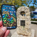
Peninsula Stained Glass Badge, Fundraiser in 8 hikes.
https://hikes.brucetrail.org/event/peninsula-stain-glass-badge-fundraiser/Sorry, the registration cut-off time for this hike has been reached.Not a member? Click here to join today!Hike open to BTC Members only.
This is a Multi-Day Hike
You are signing up for the following dates and times:
2024-08-06 at 09:00
2024-08-07 at 08:30
2024-08-08 at 08:30
2024-08-09 at 08:30
2024-08-19 at 09:00
2024-08-20 at 08:30
2024-08-21 at 08:30
2024-08-22 at 08:30Hosting Club: Toronto, Peninsula
Category: Car Hike
Location (Google Maps): BlueWater park, Wiarton, km 0.0 coordinates N 44.742514,W 81.135140 map 35Hike Leader(s): Smadar Junkin Click here to contact Hike Leader(s)
Pace: Brisk
Terrain: Challenging, Variable
Distance: 24.4 kmDescription
Thank you for registering to the Stain Glass, fund raising hike of the Peninsula. This will be a fundraising hike series in 8. Each hiker will be allowed to miss one hike and make it on their. The funds for this hike will be collected by the Toronto club and it will be transferred to the Peninsula club to help maintain the trail and keep the pledge of Ribbon Of Wilderness For Everyone, Forever.
on the first hike we will shuttle to km and hike back.
hike 2- we will meet at km 44.1, Hope Bay coordinates N 44.902930,W 81.155706 map 37 and shuttle to km 24.4hike 3- we will meet at km 44.1, Hope Bay and will shuttle to km 67.9 and walk back.
hike 4- we will meet at km 87.5, Richardson Side Trail, coordinates N 45.020460,W 81.283790 map 39, we will shuttle to km 67.9 and walk back.
hike 5- we will meet at Richardson SideTrail and shuttle to km 110.6 – (may be a paid parking) and walk back.hike 6- we will meet at km 110.6 coordinates N 45.147416,W 81.338921 map 40, we will shuttle to km 125.4 Crane Lake and walk back.
hike 7- we will meet at Crane Lake, km 124.4 coordinates N 45.190813,W 81.419658, map 41 we will shuttle to Cyprus Lake, parking B. this is a paid parking and will add about 2km to the hike. We will go on the trail that leads to mars lake, km 145.5 and walk back.
hike 8- we will park in Tobermory, there are some places that are free parking, we will park in a free parking place that I will explain how to get there during the duration of the hike. We will shuttle to cypress Lake, ( paid parking) and walk back. It’s badge day at the cairn, pictures and treats.
please bring 2 or more litres of water, snacks and lunch. Everyone is expected to participate in the shuttle once or twice in the duration of the 8 days.lets go and have fun on the trail.
- 07August 7, 2024
Car Hike: Midweek Fitness Walk Around Island Lake (8.5 km)
https://hikes.brucetrail.org/event/car-hike-midweek-fitness-walk-around-island-lake-8-5-km/Sorry, the registration cut-off time for this hike has been reached.Not a member? Click here to join today!Hosting Club: Toronto
Category: Car Hike
Location (Google Maps):Island Lake Conservation Area (Hwy 10 and 4th Ave intersection)
Hike Leader(s): Natalia Svechnikova Click here to contact Hike Leader(s)
Pace: Moderate
Terrain: Flat
Distance: 8.3 kmDescription
Please join me for an enjoyable fitness walk on a relatively flat and easy trail around the lake in the Island Lake Conservation area. The trail has treed sections as well as boardwalks near the water, meadows with beautiful flowers and much more. We will keep some steady but still comfortable pace of approximately 3 km/h. We will have a short break on the picnic area after about 6 km. Please bring 2 L of water, sunglasses, hut and some snacks/light lunch. We will meet at the start of the trail (near the large trail map) at 4th Ave and Hwy 10 intersection. You can park anywhere at the Zehrs Orangeville, Winners or Mark’s parking lot which is just across Hwy 10,