|
Sun | Mon | Tue | Wed | Thu | Fri | Sat |
|---|
January | January | January | January | 1 | 2 | 3  CANCELLED Winter Coach Trip: Kawartha Nordic CANCELLED Winter Coach Trip: Kawartha Nordic 8:00 AM-6:30 PM 02/03/2024 https://hikes.brucetrail.org/event/winter-coach-trip-kawartha-nordic-2/2024-02-03/ Click here for more information or to register Hosting Club: Toronto
Category: Cancelled
Location (Google Maps): Kawartha Nordic Hike Leader(s): Martina Furrer, Duro Vukman, George Lennon Click here to contact Hike Leader(s) Description
Bus departs from 10 York Mills Rd at 8 AM. Please arrive 15 minutes before departure. The bus waits for no one. Join us for a fantastic day of cross-country skiing and snowshoeing at Kawartha Nordic on the beautiful Canadian Shield. Bring some seeds and feed the chickadees. Snowshoers: Join Duro and George for a fun-filled guided snowshoe hike, or team up with some friends and explore the trails at your own pace. Skiers: Explore the forest on 46 km of trails groomed for classic and skate skiing. Keep your eyes peeled for deer. Classic ski and skate ski rentals available. Limited snowshoe rentals available so best to bring your own. If renting equipment, complete the rental form and bring it with you to the rental shop. Also, call ahead (705-931-5672) and the resort staff will have your rental package ready. Coach fares must be paid online when you register. Trail fees will be collected in cash on the bus (please bring exact change; quarters, dimes and nickels will not be accepted). Masks are mandatory while on the bus. This trip will run if there is enough snow to ski on. Hikers: It may not be clear ahead of time whether snowshoes, icers, or just boots will be the most appropriate footwear. Come prepared for anything. If the Club cancels this trip, your coach fare will be refunded.
 Car Hike: Glasgow Village Whitchurch-Stouffville Car Hike: Glasgow Village Whitchurch-Stouffville 8:30 AM-1:30 PM 02/03/2024 https://hikes.brucetrail.org/event/car-hike-glasgow-village-whitchurch-stouffville-8/2024-02-03/ Click here for more information or to register Hosting Club: Toronto Location (Google Maps): Glasgow Trail, Concession Road 2. Park in parking lot at the trail head From Highway 404 turn right to Stouffville Rd, till to the end of road and turn left on York Durham line in About 1km turn right to Webb Rd. and turn right to Concession Road 2 ,you will see parking lot in 500 metres Hike Leader(s): Mohammad Aghamiri , Click here to contact Hike Leader(s) Pace: Moderate
Terrain: Variable
Distance: 14-17KM Description
Approximately 5-hour hike, mostly flat, in the Uxbridge area It is wintertime, please bring your icers, hiking poles, warm layers of clothing, boots, and hot drinks. Some safety procedures during the hike: 1-Hikers must stay between the leader and the sweep. 2-Hikers must advise the leader or the sweep if they wish to leave the group. 3- Hikers must follow the whistle instructions: 1 blast- stay where you are; 2 blasts come to the leader; 3 blasts – come to the leader quickly. 4-Hike leader may request volunteers to stop at trail intersections, they need to help hikers to the direction the group walk and wait till they see the sweep . 5-Hikers have to make sure they can see the persons behind and in front of them.
 Urban Walk: Downtown Toronto PATH Network Urban Walk: Downtown Toronto PATH Network 10:30 AM-1:00 PM 02/03/2024 https://hikes.brucetrail.org/event/urban-walk-downtown-toronto-path-network-2/2024-02-03/  Click here for more information or to register Hosting Club: Toronto
Category: Urban Walk
Location (Google Maps): Union Station – Meet in the Great Hall off of Front Street by the information desk with the clock over it. Hike Leader(s): Tom Swales Click here to contact Hike Leader(s) Pace: Leisurely Distance: 5 km Description
Join us for an exploration of Toronto’s underground PATH Network that connects office buildings, subway stations, shops, and sports and entertainment venues across downtown Toronto. While mostly outdoors we’ll venture outside briefly to see the “Labyrinth” in Trinity Square and City Hall and Nathan Phillips Square. Inside we’ll see the vault of the Bank of Toronto, artwork, and even a waterfall. After the walk we will end with lunch at Longo’s across from the Scotiabank Arena, a short walk back to Union Station. Note that some escalators are not powered on the weekend so expect some stair climbs.
- Car Hike: York Region Forest – North Tract Hike – 13 KM
10:30 AM-2:30 PM 02/03/2024 https://hikes.brucetrail.org/event/car-hike-york-region-forest-north-tract-hike-13-km/2024-02-03/ 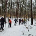 Click here for more information or to register Hosting Club: Toronto
Category: Car Hike
Location (Google Maps): 17054 ON-48, Whitchurch-Stouffville Hike Leader(s): Alina Lin Click here to contact Hike Leader(s) Pace: Moderate
Terrain: Flat
Distance: 13KM Description
Not sure how much snow is left out there but it is always nice to get some crispy fresh air in the winter forest. Very likely, the trails will be icy after the following predicted-to-be-zero-degree days and so icers would be required. Meetup location: 17054 ON-48, Whitchurch-Stouffville, GPS (44.081711358420804, -79.31146662470654). Noted: - Bring snack or light lunch, and beverage;
- Wear Waterproof hiking boots;
- Bring icers/crampons in case;
- Dress for weather.
- Trekking poles are recommended.
|
4 - Urban Walk: Waterfront Trail 3/8 – Long Branch
10:00 AM-1:00 PM 02/04/2024 https://hikes.brucetrail.org/event/urban-walk-waterfront-trail-3-8-long-branch-2/2024-02-04/  Click here for more information or to register Hosting Club: Toronto
Category: Urban Walk
Location (Google Maps): Etobicoke Waterfront Trail Hike Leader(s): Brian Rideout Click here to contact Hike Leader(s) Pace: Moderate
Terrain: Flat
Distance: 9 km Description
Please join me at Kipling Station by 9:15 am. We will take the 123 bus departing 9:30 am, arriving 9:53 am. If you want to meet us at the Long Branch loop, be there by 9:53 am. We start hiking at 10:00 am. We will hike to the lake and then east to Parklawn. There we can catch a bus to Old Mill Station or take the Lakeshore bus / streetcar. The estimated distance is 9 km. Here is an online map of our route – Long Branch to Parklawn Bring a snack, at least 2 liters of water, and icers. Dress for cold weather.
- Hike and Art: Woodbine Subway Station to Leslieville via Ashbridge’s Bay Park
10:30 AM-2:30 AM 02/04/2024 https://hikes.brucetrail.org/event/hike-and-art-woodbine-subway-station-to-leslieville-via-ashbridges-bay-park/2024-02-04/  Click here for more information or to register Hosting Club: Toronto
Category: Urban Walk
Location (Google Maps): Please meet in front of Woodbine Subway Station on Woodbine Avenue. Hike Leader(s): Andrew Proczek Click here to contact Hike Leader(s) Pace: Moderate
Terrain: Flat
Distance: 11 km Description
We will hike to Woodbine Beach and Ashbridge’s Bay Park via a collection of parks and trails, including the little known Small’s Creek and Williamson Ravine. Our destination will be Leslie Grove Gallery, 1158 Queen Street East, in Leslieville where one of our finest new hike leaders, KJ Chong (Ke-Jia) will be exhibiting an artwork for the first time in an indoor gallery as part of a group show. For KJ the last few years have been a parallel journey between becoming a hike leader for TBTC and an artist and she very proficient at both. Please join me as we celebrate a talented and outstanding person among us. KJ will be on hand to greet us. The Route:https://onthegomap.com/s/svqu40d2
| 5 | 6 | 7 | 8 - Car Hike: Caledon E2E hike #1/4
8:30 AM-2:30 PM 02/08/2024 https://hikes.brucetrail.org/event/car-hike-caledon-e2e-hike-1-4/2024-02-08/ Hike open to BTC Members only. Click here for more information or to register Hosting Club: Toronto
Category: Car Hike
Location (Google Maps): Km 2.8. North end of Chonguacousy Rd. Coordinates N 43.785429,W 79.943325 Hike Leader(s): Smadar Junkin Click here to contact Hike Leader(s) Pace: Brisk
Terrain: Hilly, Variable
Distance: 15.93 Description
For all the badge lovers hikers- this hike series can earn you three badges. The vintage badge, the Caledon 60 years badge and the winter Caledon badge. This hike will include some car juggling at the start of the hike to km 0.0. We will go through the Forks Of The Credit area.
snowshoes and icers are mandatory to this hike as we will not know which additional footwear we will need, so we need to bring both. Bring 2 litres of water. The Caledon section has some challenging areas, be prepared for that. We will meet at 8:15 and be ready for the shuttle by 8:30. All participants should be prepared to participate in car shuttles during the 4 days. Be prepared for a change of date in case of bad road conditions and heavy snow.
- Urban Walk: Valley View Park Thornhill
8:30 AM-11:00 AM 02/08/2024 https://hikes.brucetrail.org/event/urban-walk-valley-view-park-thornhill-8/2024-02-08/
| 9 - Car Hike: Caledon E2E and winter badge 2/4
8:30 AM-3:00 PM 02/09/2024 https://hikes.brucetrail.org/event/car-hike-caledon-e2e-and-winter-badge-2-4/2024-02-09/ Hike open to BTC Members only. Click here for more information or to register Hosting Club: Toronto
Category: Car Hike
Location (Google Maps): Km 35.0 Coordinates N 43.937967,W 79.934650 Hike Leader(s): Smadar Junkin Click here to contact Hike Leader(s) Pace: Brisk
Terrain: Challenging, Hilly
Distance: 19km Description
We will shuttle to km 15.9 and hike back. The hike includes road walking. Be ready for cold winds on the road sections. This hike will qualify for the winter badge. We will allow time for that badge. Must have icers and snowshoes. Bring 2 litres of water. We will follow covid 19 rules. Check for change of date before the hike in case of bad weather.
- Car Hike; Forest Ecology with Adam Brylowski
10:30 AM-2:00 PM 02/09/2024 https://hikes.brucetrail.org/event/car-hike-forest-ecology-with-adam-brylowski/2024-02-09/ 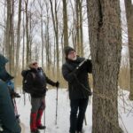 Click here for more information or to register Hosting Club: Toronto
Category: Car Hike
Location (Google Maps): Meet at parking lot opposite Limehouse Public School, on the south side of 22 Sideroad, just north of Fifth Line.
Hike Leader(s): Janet Patterson Click here to contact Hike Leader(s) Pace: Leisurely
Terrain: Variable
Distance: approx 3 km Description As you walk along the trail, do you ever stop to wonder how the forest you are travelling through evolves over time? Would you like to know more about the particular tree species we will identify, and how their growth has been affected by changes to the climate and human intervention? This is your chance to delve into the complexities of forest ecology with the assistance of our knowledgeable guide, Adam Brylowski, a staff ecologist with the Bruce Trail Conservancy. Please dress for the weather, and along with your curiosity, we suggest a hot drink, water and lunch or snack. End time and the distance we’ll travel are estimates, depending on weather and trail conditions. NOTE: Icers are strongly suggested, as well as hiking poles that will be required for at least one short, steep hill we’ll need to climb. This hike is brought to you by the TBTC’s Biodiversity Team, represented by George Lennon and Janet Patterson. We endeavour to promote the critical role we can all play in protecting and conserving the Niagara Escarpment. Limit of 10 participants
| 10 -
 Winter Coach Trip: Awenda Provincial Park Winter Coach Trip: Awenda Provincial Park 8:00 AM-6:00 PM 02/10/2024 https://hikes.brucetrail.org/event/winter-coach-trip-awenda-provincial-park-2/2024-02-10/ Trip Information
Departure Time: 08:00
Return to City Time: 18:00
Departure Point: York Mills Bus Pickup Click here for more information or to register Trip Activities
Pick up at Yonge & York Mills ($0.01)
Pick up at Major Mac ($0.01)
Optional Items
Hosting Club: Toronto
Category: Coach Trips
Location (Google Maps): Awenda Provincial Park Hike Leader(s): Martina Furrer, Nijole Mockevicius, Lisa Lifshitz Click here to contact Hike Leader(s) Description
Bus departs 10 York Mills Rd at 8:00 AM and Major Mackenzie Dr and HWY 400 Park and Ride at 8:20 AM. If you wish to be picked up at the Major Mackenzie Dr and HWY 400 Park and Ride, select that option when you register. Please arrive 15 minutes before departure. The bus waits for no one. Join us for a super fun winter day in beautiful Awenda Provincial Park. Be prepared to pick your activity according to the conditions. If snowshoeing is good – great! If winter hiking is better – enjoy! If skiing is possible – bonus! The trip will run no matter what. Driving time to Awenda is 1.75 hours. It’s so worth it to spend the day on the shore of Georgian Bay. Winter hikers: Explore the trails on your own or join Nijole and Lisa for a guided 10 KM hike on Awenda’s beautiful winter trails. The hike will traverse parts of the Bluff, Wendat, and Connector trails, and will also circle around Kettle’s Lake. Mostly flat with a few short hills. Pace will be approximately 3 km/hr. Plenty of time to take pictures and enjoy the scenery. Skiers: If conditions allow, enjoy self-guided tours of Awenda’s beautiful ski trails with majestic views of Georgian Bay. No rentals. No food or drink. For information about trail conditions visit: https://www.ontarioparks.com/skireport. Coach fare must be paid online when you register. Masks are mandatory while on the bus. Hikers: It may not be clear ahead of time whether snowshoes, icers, or just boots will be the most appropriate footwear. Come prepared for anything. If the Club cancels this trip, your coach fare will be refunded.
- Car Hike: Hike of 2 lakes King city
8:30 AM-1:30 PM 02/10/2024 https://hikes.brucetrail.org/event/car-hike-hike-of-2-lakes-king-city-11/2024-02-10/ Click here for more information or to register Hosting Club: Toronto Location (Google Maps): Park along Fairfield Dr. or Dufferin Street. Gather at trail head on Dufferin Street. Hike Leader(s): Mohammad Aghamiri Click here to contact Hike Leader(s) Pace: Moderate
Terrain: Variable
Distance: 14-17KM Description
We will hike in trails around Seneca lake and Mary Lake,pass by Eaton and visit Pine farm where you can enjoy coffee,tea,apple pie during our snack time. Some safety procedures during the hike: 1-Hikers must stay between the leader and the sweep. 2-Hikers must advise the leader or the sweep if they wish to leave the group. 3- Hikers must follow the whistle instructions: 1 blast- stay where you are; 2 blasts come to the leader; 3 blasts – come to the leader quickly. 4-Hike leader may request volunteers to stop at trail intersections, they need to help hikers to the direction the group walk and wait till they see the sweep . 5-Hikers have to make sure they can see the persons behind and in front of them.
- Campfire under the stars – Let’s beat the Winter Blues!
4:00 PM-6:00 PM 02/10/2024 https://hikes.brucetrail.org/event/campfire-under-the-stars-lets-beat-the-winter-blues/2024-02-10/  Click here for more information or to register Hosting Club: Toronto
Category: Urban Walk
Location (Google Maps): High Park Nature Centre Hike Leader(s): Marie-Josée Roy Click here to contact Hike Leader(s) Pace: Leisurely
Terrain: Variable
Distance: n/a Description
Please join us for a short hike in High Park, and then gather around a campfire. We’ll have some sausages, buns, condiments, and s’mores, but feel free to bring whatever you would like to roast on the fire. And if you are so inclined, bring a guitar, harmonica, or ukulele, and your best camp songs! The High Park Nature Centre is a 6-minute walk from High Park subway station. Please remember that the park is closed to all vehicle traffic on weekends. What to bring: - Proper footwear
- Warm clothing
- Hot drinks (tea, coffee, soup, etc.)
Hike (optional): 4:00-5:00 p.m. Campfire: 5:00-6:00 p.m.
|
11 - Urban Walk: Waterfront Trail 4/8 – Parklawn
10:00 AM-1:00 PM 02/11/2024 https://hikes.brucetrail.org/event/urban-walk-waterfront-trail-4-8-parklawn-3/2024-02-11/  Click here for more information or to register Hosting Club: Toronto
Category: Urban Walk
Location (Google Maps): Toronto Waterfront Trail Hike Leader(s): Brian Rideout Click here to contact Hike Leader(s) Pace: Moderate
Terrain: Flat
Distance: 9.1 km Description Please join me at Old Mill Station no later than 9:12 am. We will take the 66 bus departing 9:27 am, arriving 9:40 am. If you want to meet us at Parklawn and Lakeshore, please be there by 9:40 am. We start hiking at 9:50 am. We will hike east along the lake to Spadina. The estimated distance is 9.1 km. Here is an online map of our route Parklawn to SpadinaBring a snack, at least 2 liters of water, and icers. Dress for cold weather. - Car Hike: Mono Cliffs
10:30 AM-2:30 PM 02/11/2024 https://hikes.brucetrail.org/event/car-hike-mono-cliffs-5/2024-02-11/ Click here for more information or to register Hosting Club: Toronto
Category: Car Hike
Location (Google Maps): Mono Cliffs Prov. Park, Map 19 Hike Leader(s): Al Brown Click here to contact Hike Leader(s) Pace: Moderate
Terrain: Variable
Distance: 8 Km Description
This will be a loop winter hike through the Park starting at the Mono Community Centre. The terrain is variable and mostly flat. The hike will take approximately 3 hours and may be shortened depending on weather. After the hike those interested are invited to stop for refreshments in the area. Bring snow shoes if you have them and icers. To get to the meeting point drive north on Hwy 10 past Orangeville to County Road 8 (at Camilla). Turn right and take the Road 8 into Mono Centre. The parking area is just before the Community Centre on your right. Parking is free.
| 12 | 13 | 14 | 15 | 16 - Feb. 16-19, 2024 – Family Day Snowshoe Weekend in Tobermory (3 nights)
12:00 AM 02/16/2024 https://hikes.brucetrail.org/event/feb-16-19-2024-family-day-snowshoe-weekend-in-tobermory-3-nights/2024-02-16/  Click here for more information or to register Hosting Club: Toronto
Category: Car Hike
Location (Google Maps): Princess Hotel
34 BAY STREET SOUTH TOBERMORY, ONTARIO N0H 2R0, CANADA Hike Leader(s): Jeanette Vincent Click here to contact Hike Leader(s) Pace: Moderate
Terrain: Variable Description
Jeanette Vincent, Brenda and David Royle will continue the tradition of Greg Vincent’s Family Day Snowshoe Weekend in Tobermory. Celebrate with a weekend trip snowshoeing the trails of the National Park at the “Tip o’ the Bruce” Tobermory. We arrive Friday, February 16th at our comfortable hotel overlooking Little Tub Harbour where we stay and have our meals for three nights at the Princess Hotel in Tobermory. This outing is restricted to those staying and having their meals with us at the Princess Hotel in Tobermory for the weekend. Please email Jeanette for the prices for the weekend at the Princess Hotel package and additional information. If you plan to join us call the Princess for rates and a reservation 1-519-596-8282 or info@tobermoryprincesshotel.com and mention Vincent/Royle Winter Snowshoe weekend when booking. Once you have made your reservation, be sure to register for this event on the Toronto Bruce Trail Club please email Jeanette at vincentjeanette1604@gmail.com once you are registered and made your reservation.
| 17 - Car Hike: Bethesda Trail Richmond Hill
8:30 AM-1:45 PM 02/17/2024 https://hikes.brucetrail.org/event/car-hike-bethesda-trail-richmond-hill-15/2024-02-17/ Click here for more information or to register Hosting Club: Toronto Location (Google Maps): Meet at Bethesda Trail Head Parking on Bethesda Sideroad off Bayview Avenue, across from Lake Wilcox. This parking lot is free. Hike Leader(s): Mohammad Aghamiri Click here to contact Hike Leader(s) Pace: Moderate
Terrain: Variable
Distance: 14-17KM Description
Join us to explore Jefferson Forest and Bond lake , Please bring hiking poles, proper closing and shoes and lots of water, Please carefully read safety procedures during the hike: 1-Hikers must stay between the leader and the sweep. 2-Hikers must advise the leader or the sweep if they wish to leave the group. 3- Hikers must follow the whistle instructions: 1 blast- stay where you are; 2 blasts come to the leader; 3 blasts – come to the leader quickly. 4-Hike leader may request volunteers to stop at trail intersections, they need to help hikers to the direction the group walk and wait till they see the sweep . 5-Hikers have to make sure they can see the persons behind and in front of them.
- Cancelled: Winter Coach Trip: Horseshoe Resort
9:00 AM-6:00 PM 02/17/2024 https://hikes.brucetrail.org/event/winter-coach-trip-horseshoe-resort-2/2024-02-17/ Click here for more information or to register Hosting Club: Toronto
Category: Cancelled
Location (Google Maps): Horseshoe Resort Hike Leader(s): Martina Furrer, Duro Vukman, George Lennon Click here to contact Hike Leader(s) Description
Bus departs 10 York Mills Rd at 9:00 AM and Major Mackenzie Dr and HWY 400 Park and Ride at 9:20 AM. If you wish to be picked up at the Major Mackenzie Dr and HWY 400 Park and Ride, select that option when you register. Please arrive 15 minutes before departure. The bus waits for no one. Join us for an awesome day of x-country skiing and snowshoeing/winter hiking. For trail conditions and information about the resort visit: www.horseshoeresort.com Snowshoers: Join Duro and George for a guided snowshoe hike on the Friends of the Copeland Forests Trails. You must have your own snowshoes (or rent in the city) to participate in this hike. Pack lunch and water; you will be on the trail all day. Skiers: Spend your day gliding through the beautiful Copeland Forest on trails expertly groomed for classic and skate skiing. All skiing is self-guided. Ski and snowshoe rentals available. Please book ahead at: http://horseshoeresort.com/nordic-centre/cross-country-skil Coach fares must be paid online when you register. Trail fees will be collected in cash on the bus. Masks are mandatory while on the bus. This trip will run if there is enough snow to ski on. Hikers: It may not be clear ahead of time whether snowshoes, icers, or just boots will be the most appropriate footwear. Come prepared for anything. If the Club cancels this trip, your coach fare will be refunded.
- Urban Walk: Graffiti Art, Culture & Nature in Toronto
10:00 AM-1:00 PM 02/17/2024 https://hikes.brucetrail.org/event/graffiti-art-culture-nature-in-toronto-2/2024-02-17/  Click here for more information or to register Hosting Club: Toronto
Category: Urban Walk
Location (Google Maps): Meet at the South-West corner of Harbord & Spadina Hike Leader(s): Sajedeh Zahraei Click here to contact Hike Leader(s) Pace: Leisurely
Terrain: Flat Description
This hike is part of a series of urban hikes exploring graffiti art, culture, and social history in Toronto’s streets, laneways, underpasses, and parks across the city. These hikes provide opportunities for reflection on our own identity, personal history, examining our connection to each other and to the land, fostering a sense of community and belonging. In this hike we will explore Harbord Village, Little Italy, and Kensington.
- Urban Walk: Cootes Paradise (By GO Transit)
10:15 AM-2:30 PM 02/17/2024 https://hikes.brucetrail.org/event/urban-walk-cootes-paradise-by-go-transit-2/2024-02-17/ Click here for more information or to register Hosting Club: Toronto
Category: Urban Walk
Location (Google Maps): McMaster University GO Bus Terminal. Transit riders may meet at the Great Hall in Union Station at 8:30 to take the 8:45 AM Westbound Lakeshore Line train to Aldershot (or join us at stations on the way). At Aldershot we connect with the GO bus to McMaster University. Hike Leader(s): Tom Swales, Makhan Dhesi Click here to contact Hike Leader(s) Pace: Moderate
Terrain: Hilly
Distance: 9 Description
Join us for a Winter visit to the scenic trails of Cootes Paradise by McMaster University to Princess Point where a fire pit, skaters, and hot chocolate await. Icers are a must for the trails and hills. From Princess Point we’ll proceed to West Hamilton for GO Bus connections to Aldershot or the express bus to Union Station. You may also return to McMaster. Cootes Paradise is a beautiful nature getaway and the largest, most diverse sanctuary in the Royal Botanical Gardens spanning over 600 hectares. On the trails and their lookouts you may spot wildlife, even in Winter. Princess Point has local bus service if you don’t wish to walk further. Dress warmly for the weather and bring icers and hot drinks.
|
18 - Car Hike: Hike #2 to earn the Dufferin Hi-Land Youth and/or Side Trails Badge!
10:00 AM-1:00 PM 02/18/2024 https://hikes.brucetrail.org/event/car-hike-hike-2-to-earn-the-dufferin-hi-land-youth-and-or-side-trails-badge/2024-02-18/  Click here for more information or to register Hosting Club: Toronto, Dufferin Hi-Land
Category: Car Hike
Location (Google Maps): We will meet at the Bruce Trail parking lot on 1st Line E north of 8 Sideroad at km 28.3 (Map 20 of the Bruce Trail Reference Guide, Edition 31). Hike Leader(s): Monica Pasquali Click here to contact Hike Leader(s) Pace: Leisurely
Terrain: Variable
Distance: 6.1 km Description
Calling all families with children who love hiking and earning badges!!! This is the second in a series of ten hikes that will be offered throughout 2024 on a roughly monthly basis so that children who are 15 years of age and younger can earn the Dufferin Hi-Land Adventurer Youth Badge and their parents/guardians can earn the Dufferin Hi-Land Side Trails Badge at the same time!!! Details regarding the requirements for each badge can be found here: https://dufferinbrucetrailclub.org/dufferin-bruce-trail-club-badges/ Each of the ten hikes will be a loop hike so no car shuttles will be needed, and each hike will cover a distance of approximately 6-9 km hiked at a leisurely pace (2-3 km/h) so children and adults alike can participate. This second hike will be a winter hike to explore some side trails north of Boyne Valley Provincial Park, specifically the Rock Hill Park Side Trail, David Hahn Side Trail, Enchanted Forest Side Trail, Oliver Creek Side Trail, and Moss Haven Side Trail. Please dress appropriately for a winter hike by dressing in layers (wear an inner layer that wicks sweat away from your skin, a middle layer that keeps you warm, and an outer layer that protects you from wind and snow), wearing gloves/mittens and a toque, and wearing warm and comfortable footwear that has good traction in snow/ice (icers placed over your boots work great!). Hiking poles or walking sticks are an asset since they will help keep you balanced if the ground is slippery. As well, make sure you bring enough water and food for a 2-3 hour hike since we’ll be covering a total distance of approximately 6.1 km.
- Urban Walk: Waterfront Trail 5/8 – Bathurst
10:00 AM-1:00 PM 02/18/2024 https://hikes.brucetrail.org/event/urban-walk-waterfront-trail-5-8-bathurst-2/2024-02-18/  Click here for more information or to register Hosting Club: Toronto
Category: Urban Walk
Location (Google Maps): Toronto Waterfront Trail Hike Leader(s): Brian Rideout Click here to contact Hike Leader(s) Pace: Moderate
Terrain: Flat
Distance: 9.4 km Description Please join me at Bathurst Station no later than 9:00 am. We will take the streetcar southbound departing 9:38 am, arriving at Adelaide St 9:54 am. If you want to meet us at Bathurst and Adelaide, be there by 9:54 am. We start hiking at 10:00 am. We will hike to the lake and east to Leslie St. The estimated distance is 9.4 km. Here is an online map of our route Bathurst to LeslieBring a snack, at least 2 liters of water, and icers. Dress for cold weather.
| 19 - Urban Walk: Toronto Islands Family Day Hike
10:15 AM-4:30 PM 02/19/2024 https://hikes.brucetrail.org/event/urban-walk-toronto-islands-family-day-hike/2024-02-19/ Click here for more information or to register Hosting Club: Toronto
Category: Urban Walk
Location (Google Maps): Meet inside the waiting area of Jack Layton Ferry Terminal at the foot of Bay Street at 10:15AM to take the 10:30 AM Ferry to Ward’s Island. Ferry tickets can be purchased when you arrive or online. Ferry return fares: $10.50 adult, $6.75 student/senior Hike Leader(s): Ray Berzins Click here to contact Hike Leader(s) Pace: Moderate (3-4 km/hr)
Terrain: Flat, Level 1 (Easy – mostly on flat, well maintained trails with hard-packed surface)
Distance: 12 km Description
The Toronto Islands are very peaceful in the Winter Season. We will catch the 3:45 pm or 4:15 pm ferry to be back in the city by 4:30 pm. Bring a lunch, snacks, water, a hot beverage, and icers if available. Dress in warm layers appropriate to the weather. Heated washrooms available. Dropout anytime by walking back to the Ward’s Island Ferry Dock. We will hike to Hanlan’s Point and return to Ward’s Island (only destination served in the Winter) – approximately 6 km each way.
| 20 | 21 | 22 - Car Hike: Caledon E2E and winter badge 3/4
8:30 AM-3:00 PM 02/22/2024 https://hikes.brucetrail.org/event/car-hike-caledon-e2e-and-winter-badge-3-4-2/2024-02-22/ Click here for more information or to register Hosting Club: Toronto
Category: Car Hike
Location (Google Maps): Km 35.0 coordinates N 43.937967,W 79.934650 Hike Leader(s): Smadar Junkin Click here to contact Hike Leader(s) Pace: Brisk
Terrain: Challenging, Hilly
Distance: 17 km. Description
We will shuttle to km 51.8 and walk back, some challenging hills. Bring snowshoes and icers. Bring 2 litres of water. This hike will also be used for the winter badge as we will make the time for it. Make sure to check your email before the hike for a change of date because of bad weather. We will follow covid 19 rules. We will meet at 8:15 and be ready to shuttle by 8:30.
- Urban Walk: Valley View Park Thornhill
8:30 AM-11:00 AM 02/22/2024 https://hikes.brucetrail.org/event/urban-walk-valley-view-park-thornhill-12/2024-02-22/
| 23 - Car Hike: Caledon E2E and winter badge 4/4
8:30 AM-3:00 PM 02/23/2024 https://hikes.brucetrail.org/event/car-hike-caledon-e2e-and-winter-badge-4-4-2/2024-02-23/ Hike open to BTC Members only. Click here for more information or to register Hosting Club: Toronto
Category: Car Hike
Location (Google Maps): Km 51.8 Coordinates N 43.993572,W 80.014057 Hike Leader(s): Smadar Junkin Click here to contact Hike Leader(s) Pace: Brisk
Terrain: Challenging, Variable
Distance: 21 Description
Last hike in the series. Badges day. We will shuttle to the end of the Caledon section and walk back on the new section of the trail. Bring snowshoes and icers. Bring 2 litres of water. Check your email for change of date because of bad weather. We will follow covid 19 rules.
- #1/4 Feb 23 -26 Sydenham Bruce Trail – Boyd Crevice Hike 6KM
12:00 PM-2:30 PM 02/23/2024 https://hikes.brucetrail.org/event/sydenham-bruce-trail-boyd-crevice-hike-6km/2024-02-23/ 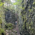 Click here for more information or to register Hosting Club: Toronto, Sydenham
Category: Car Hike
Location (Google Maps): 11th Concession & CP Rail Trail Hike Leader(s): Alina Lin Click here to contact Hike Leader(s) Pace: Moderate
Terrain: Challenging, Hilly, Rocky
Distance: 6KM Description This is one of the four day hikes scheduled from Feb 23 to 26. If you are interested in participating in all four hikes and staying in an Airbnb with some of us, please reach out to me. Meetup location: parking where 11th Concession intersects the rail trail. GPS coordinates: 44.553479, -80.908903. This will be a go-and-back hike along the Bruce Trail main trail starting from 11th Concession to 10th Concession. We will stop at the Boyd Crevices for photo break and admire the spectacular crevices between those giant dolostone blocks. It may not be clear ahead of time whether snowshoes are needed or just icers will be sufficient. Come prepared for anything. Icers/microspikes are a must-have.
| 24 - Car Hike: Cherry Beach Downtown Toronto
8:30 AM-1:30 PM 02/24/2024 https://hikes.brucetrail.org/event/car-hike-cherry-beach-downtown-toronto-5/2024-02-24/ Click here for more information or to register Hosting Club: Toronto Location (Google Maps): Cherry Beach Parking Lot, at the foot of Cherry Street (Free Parking) Hike Leader(s): Mohammad Aghamiri Click here to contact Hike Leader(s) Pace: Moderate
Terrain: Flat
Distance: 14-17KM Description
We will hike along the waterfront trail. Dress warmly, bring icers and hot drinks. Some safety procedures during the hike: 1-Hikers must stay between the leader and the sweep. 2-Hikers must advise the leader or the sweep if they wish to leave the group. 3- Hikers must follow the whistle instructions: 1 blast- stay where you are; 2 blasts come to the leader; 3 blasts – come to the leader quickly. 4-Hike leader may request volunteers to stop at trail intersections, they need to help hikers to the direction the group walk and wait till they see the sweep . 5-Hikers have to make sure they can see the persons behind and in front of them.
- Cancelled: Winter Coach Trip: Mansfield Outdoor Centre
9:00 AM-6:00 PM 02/24/2024 https://hikes.brucetrail.org/event/winter-coach-trip-mansfield-outdoor-centre/2024-02-24/ Click here for more information or to register Hosting Club: Toronto
Category: Cancelled
Location (Google Maps): Mansfield Outdoor Centre Hike Leader(s): Martina Furrer, Brenda Dalglish, Celia Ho Click here to contact Hike Leader(s) Description
Bus departs 10 York Mills Rd at 9:00 AM and Major Mackenzie Dr and HWY 400 Park and Ride at 9:20 AM. If you wish to be picked up at the Major Mackenzie Dr and HWY 400 Park and Ride, select that option when you register. Please arrive 15 minutes before departure. The bus waits for no one. Join us for an awesome day of x-country skiing and snowshoeing/winter hiking. For trail conditions and information about the resort visit: https://mansfieldoutdoorcentre.ca/ Snowshoers: Join Brenda and Celia for a guided snowshoe hike at beautiful Mansfield. Pack lunch and water; you will be on the trail all day. Skiers: Spend your day gliding through Mansfield’s forests and fields on trails expertly groomed for classic and skate skiing. All skiing is self-guided. Classic ski ($35 + HST) and snowshoe ($25 + HST) rentals available; quantities are limited. Coach fares must be paid online when you register. Trail fees will be collected in cash on the bus. Masks are mandatory while on the bu
- Car Hike: Caledon section
9:00 AM-3:30 PM 02/24/2024 https://hikes.brucetrail.org/event/car-hike-caledon-winter-badge/2024-02-24/  This is a Multi-Day HikeYou are signing up for the following dates and times:
2024-02-24 at 09:00
2024-03-02 at 09:00 Click here for more information or to register Hosting Club: Toronto
Category: Car Hike
Location (Google Maps): Caledon Bruce trail Hike Leader(s): Lindita Kalo Click here to contact Hike Leader(s) Pace: Fast, Moderate
Terrain: Variable
Distance: 8-13Km Description
If you working on Caledon 60th anniversary badge those hikes are for you. Distance and coordinate to meet will be e- mailed after registering. Loops or drive back to cars.
Hikers should anticipate winter conditions-boots,icers,snow shoes if needed.We will take turns shttling from meeting place and take the shuttle driver back to their cars when neeed.
We will hike within 3-4k per hour. Please ensure you are physically able to manage pace and distance on winter conditions. Please be true of your physical level.The leader may change the hike dates due to winter conditions. Closer to hike dates more detail e-mail will be send to hikers.
Arrive 15 minutes early. Some paid parking.
- #2/4 Feb 23 -26 Peninsula Bruce Trail – Jackson’s Cove to Rush Cove – 14km
10:00 AM-3:00 PM 02/24/2024 https://hikes.brucetrail.org/event/peninsula-bruce-trail-jacksons-cove-to-rush-cove-14km/2024-02-24/ 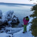 Click here for more information or to register Hosting Club: Toronto, Peninsula
Category: Car Hike
Location (Google Maps): Scenic Caves Rd Parking Hike Leader(s): Alina Lin Click here to contact Hike Leader(s) Pace: Moderate
Terrain: Challenging, Hilly, Rocky, Variable
Distance: 12km – 14km Description
This is one of the four day hikes scheduled from Feb 23 to 26. If you are interested in participating in all four hikes and staying in an Airbnb with some of us, please reach out to me. Meetup at the Bruce Trail Parking located at the east end of Scenic Caves Rd. GPS coordinates: 44.953282, -81.128023. We will hike a combination of main trail and side trails between Rush Cove and Jackson’s Cove. The terrain is challenging with some deep ups and downs of escarpment. Pack lunch and water. No dogs. It may not be clear ahead of time whether snowshoes are needed or just icers will be sufficient. Come prepared for anything. Icers/microspikes are a must-have.
|
25 - #3/4 Feb 23 -26 Bruce Peninsula National Park Hike – 12km
10:00 AM-3:00 PM 02/25/2024 https://hikes.brucetrail.org/event/bruce-peninsula-national-park-hike-12km/2024-02-25/  Click here for more information or to register Hosting Club: Toronto, Peninsula
Category: Car Hike
Location (Google Maps): Bruce Peninsula National Park Parking Lot Hike Leader(s): Alina Lin Click here to contact Hike Leader(s) Pace: Moderate
Terrain: Challenging, Hilly, Rocky, Variable
Distance: 10km -12km Description
This is one of the four day hikes scheduled from Feb 23 to 26. If you are interested in participating in all four hikes and staying in an Airbnb with some of us, please reach out to me. Meetup at the Bruce Peninsula National Park parking lot. GPS coordinates: 45.236363, -81.522626. Admission and parking fees are applied by the Park. We will hike go-and-back along the main trail between Loon Lake and Halfway Dump. The terrain is rocky and rugged so be prepared for some challenges. Pack lunch and water. No dogs. It may not be clear ahead of time whether snowshoes are needed or just icers will be sufficient. Come prepared for anything. Icers/microspikes are a must-have.
- Urban Walk: Waterfront Trail 6/8 – Lakeshore East
10:00 AM-1:30 PM 02/25/2024 https://hikes.brucetrail.org/event/urban-walk-waterfront-trail-6-8-lakeshore-east-3/2024-02-25/  Click here for more information or to register Hosting Club: Toronto
Category: Urban Walk
Location (Google Maps): Toronto/Scarborough Hike Leader(s): Brian Rideout Click here to contact Hike Leader(s) Pace: Moderate
Terrain: Flat
Distance: 10.9 km Description Please join me at the Tim Horton’s at Lakeshore and Leslie no later than 9:50 am. We start hiking at 10:00 am. We will hike east on Lakeshore, along the Beaches Boardwalk, and on Kingston Rd to Brimley Rd. The estimated distance is 10.9 km. Here is an online map of our route Lakeshore to Brimley RdBring a snack, at least 2 liters of water, and icers. Dress for cold weather. - Urban Walk: Wayne Hike: Crothers Woods to Victoria Park Subway via Flat and Taylor Creek Trails
10:30 AM-2:30 PM 02/25/2024 https://hikes.brucetrail.org/event/urban-walk-wayne-hike-crothers-woods-to-victoria-park-subway-via-flat-and-taylor-creek-trails/2024-02-25/ 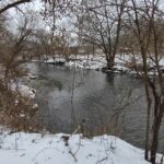 Click here for more information or to register Hosting Club: Toronto
Category: Urban Walk
Location (Google Maps): Meet inside Pape Subway Station at 10:15 to catch the #81 Thorncliffe Park bus at 10:30 to Millwood Rd and Overlea Blvd. From the bus stop we will walk along Millwood to Redway Rd on the left and follow it to the end around the Loblaws to the Thomas Hauser Memorial Trail Head. Alternatively, hikers wanting to meet us there directly by foot or car can do so. The proper hike will leave from the trail head at 11 am. Hike Leader(s): Andrew Proczek Click here to contact Hike Leader(s) Pace: Moderate
Terrain: Flat, Variable
Distance: 10 km Description
“I decided to check out an alternative route along the Don River to avoid cycle traffic on [weekends] and it is pretty nice. I picked up the trail at the parking lot for the Loblaws on Redway Road and worked down into the valley to where it intersected with the Flats Trail on the west side of the Don River. No pavement and few bikes. Mosquitoes and stinging nettles but that is better than dodging bikes. 10 km in just over 2 hours. Need to walk with people to slow down. This on the go application is very useful in planning or tracing routes after the fact.” https://onthegomap.com/s/1u3tdtku Wayne Crockett, June 12, 2020 Please join me for this original Wayne hike. Just as Wayne did we will walk from the bus stop at Millwood and Overlea, by the Loblaws to the Crothers Wood’s Trailhead to begin the proper hike which will remain in nature until we reach Dawes Road at 8.7 km. There will be no mosquitos or Stinging Nettle but the weather forecast is calling for a return to freezing temperatures, so icers may be required. And this is a good thing since Crothers Woods is known for its mud. “Mud, did someone say mud?!” I can almost hear Wayne chiding me. “Andrew, don’t be spreading rumors of mud for one of my hikes!” We will be visiting the ‘Passage’ installation under the Don Mills underpass as well as the Elevated Wetlands Sculptures a.k.a. ‘The Big Teeth’ along the route. Public washrooms at Taylor Creek Park and Dawes Road, unfortunately are closed for the season. Washrooms at the start at Loblaws and bio breaks along the trail will be offered. Please pack a lunch, water or a warm beverage. And, yes Wayne, the group will slow you down. The hike will proceed at the usual moderate pace. Optional Pub stop at the end at The Feather’s Pub, 962 Kingston Rd at Victoria Park where we can toast Wayne for a well planned hike.
| 26 - #4/4 Feb 23 -26 Peninsula Bruce Trail – Rural Rocks Side Trail Hike – 4.5km
11:00 AM-1:00 PM 02/26/2024 https://hikes.brucetrail.org/event/peninsula-bruce-trail-rural-rocks-side-trail-hike-4-5km/2024-02-26/  Click here for more information or to register Hosting Club: Toronto, Peninsula
Category: Car Hike
Location (Google Maps): Bruce Rd 13& Northacres Rd, Wiarton Hike Leader(s): Alina Lin Click here to contact Hike Leader(s) Pace: Moderate
Terrain: Challenging, Hilly, Rocky Description
This is one of the four day hikes scheduled from Feb 23 to 26. If you are interested in participating in all four hikes and staying in an Airbnb with some of us, please reach out to me. Meetup location: 30 meters north of the intersection of Bruce Rd 13& Northacres Rd. GPS coordinates: 44.753489, -81.167505. Rural Rocks Side Trail and Obese Side Trail are satellite loop side trails – probably the only two side trails that aren’t connected to the main trail. You will see a wonderland of enormous rocks left from a time when this area was the shoreline of an ancient glacial lake. Part of the loop is very rugged and challenging to walk through. No dogs. No drop out. It may not be clear ahead of time whether snowshoes are needed or just icers will be sufficient. Come prepared for anything. Icers/microspikes are a must-have.
| 27 | 28 | 29 | March | March |