Join us for a hike! Registration required:
All hikes available to BTC members. Some hikes are open to non-members.
TIP: The calendar view displays up to 7 hikes on a day, but often there are more. Click “More events” to see them all.
Toronto Hike Schedule
Toronto Bruce Trail Club Registration Live Dates
Day Winter Coach Program
Registration begins two weeks in advance of the event departure (at 8:00 PM)
Day Bus Hikes
Registration begins two weeks in advance of the event departure (at 8:00 PM) with some exceptions of special event hikes
Day Coach Hikes
Registration begins 7 weeks in advance of the event departure
Day Car Hikes and Urban Hikes
Registration begins two weeks in advance of the event departure
Overnight and Weekend Trips
Registration begins 12 weeks in advance of the event departure
To view all Bruce Trail Conservancy Hikes click here
- 24November 24, 2024

Car Hike: Exploring Uxbridge Trails (Wilder Forest, Walker Woods, and Glen Major Forest)
https://hikes.brucetrail.org/event/exploring-uxbridge-trails-wilder-forest-walker-woods-and-glen-major-forest/Sorry, the registration cut-off time for this hike has been reached.Not a member? Click here to join today!Hosting Club: Toronto
Location (Google Maps):
2499 Brock Rd, Uxbridge, ON L9P 1R4. We will meet at the East Duffins Headwaters parking lot at the WILDER
FOREST trail head. As soon as you got off the Brock Road, passing the horse back riding facility, there is a free designated parking lot 70 meters down the lane to your right. It includes a sign board for East Duffins Headwaters with a map of the trails. Please do not park on the lane or in the horse back riding property.Hike Leader(s): Amir Alemohammad Click here to contact Hike Leader(s)
Pace: Moderate (3-4 km/hr)
Terrain: Hilly, Level 2 (Intermediate – some hills and uneven surfaces, rocks and roots underfoot), Variable
Distance: Approx.14-16 KmDescription
Join us for an enjoyable fall hike in Uxbridge! We’ll explore parts of Wilder Forest, Walker Woods, and Glen Major Forest in a loop starting from Brock Road, passing Concession Road 6, heading west and back. Along the main trail, we’ll also venture onto several side trails.Please stay on the designated trails at all times. Expect beautiful scenic views and lookouts facing south, with a mix of hilly and flat segments. Be prepared for variable weather—chilly and windy conditions are likely this time of year. Boots mandatory, poles recommended.
Bring at least 2 liters of water and your favorite snacks. We’ll have frequent 2-minute breaks for hydration and lookout photos, along with a 20-minute lunch stop at the Aggregate Pit look out. Please pack your own lunch and refreshments for an enjoyable outdoor meal.
Don’t forget your camera and a smile as we explore the beauty of the Uxbridge trails!
- 25November 25, 2024
Toronto E2E (2 days) Stained Glass Fundraiser
https://hikes.brucetrail.org/event/toronto-e2e-2-days-stained-glass-fundraiser/Sorry, the registration cut-off time for this hike has been reached.Not a member? Click here to join today!Hike open to BTC Members only.
This is a Multi-Day Hike
You are signing up for the following dates and times:
2024-11-25 at 08:30
2024-11-26 at 08:30Hosting Club: Toronto, Sydenham
Category: Fundraiser
Location (Google Maps): Roadside parking on west side of 6th Line, south of Highway 7 near Georgetown (43.658281, -79.985371)Hike Leader(s): Karen Buschert Click here to contact Hike Leader(s)
Pace: Brisk: 4 to 5 km/h
Terrain: Moderate: Some hills and/or poor footing, There might be muddy sections.
Distance: Distances range from 23-26 km per dayDescription
Through this fundraising hike, you can complete the Toronto section in 2 days and earn the Stained Glass badge! Registration cost is $30 and goes to the Toronto Bruce Trail Club. We will be hiking at a moderate pace over moderate to difficult terrain. Because of the distance we need to cover each day, please ensure you have the strength and stamina for two long hiking days.Hikers should wear layered clothing, bring rainwear, poles, hiking boots, hat, water, snacks, lunch, and be prepared for changing weather this time of year.
Hiking itinerary with parking coordinates will be emailed to registered hikers. - 26November 26, 2024
Urban Walk: Valley View Park Thornhill
https://hikes.brucetrail.org/event/urban-walk-valley-view-park-thornhill-36/Sorry, the registration cut-off time for this hike has been reached.Not a member? Click here to join today!Hosting Club: Toronto
Location (Google Maps): Parking lot at the corner of Bayview Ave, and Sycamore Dr. South of Highway 7
Sycamore Dr. is 3blocks south of highway 7 and 2 blocks north of John Street, parking lot is across plaza of Dollarama and Star boxHike Leader(s): Mohammad Aghamiri Click here to contact Hike Leader(s)
Pace: Moderate (3-4 km/hr)
Terrain: Level 2 (Intermediate – some hills and uneven surfaces, rocks and roots underfoot)
Distance: 7-8 kmDescription
We will explore Valleyview and Maple view parks, and walk along German Mill Creek, for a distance of 7-8 km. Difficulty Level: 2 (Moderate) - 27November 27, 2024
Car Hike: Midweek Fitness Walk Around Island Lake (8.5 km)
https://hikes.brucetrail.org/event/car-hike-midweek-fitness-walk-around-island-lake-8-5-km-2/Sorry, the registration cut-off time for this hike has been reached.Not a member? Click here to join today!Hosting Club: Toronto
Category: Car Hike
Location (Google Maps):Island Lake Conservation Area (Hwy 10 and 4th Ave intersection)
Hike Leader(s): Natalia Svechnikova Click here to contact Hike Leader(s)
Pace: Moderate (3-4 km/hr)
Terrain: Flat
Distance: 8.5 kmDescription
Please join me for an enjoyable fitness walk on a relatively flat and easy trail around the lake in the Island Lake Conservation area. The trail has treed sections as well as boardwalks near the water, meadows and more. I think that this hike is suitable for the end of November because it will be less muddy than many other places. We will keep some steady but still comfortable pace of approximately 3 km/h. We will have a short break on the picnic area after about 6 km. Please dress for the weather and bring 2 L of water and some snacks/light lunch. We will meet at the start of the trail (near the large trail map) at 4th Ave and Hwy 10 intersection. You can park anywhere at the Zehrs Orangeville, Winners or Mark’s parking lot which is just across Hwy 10.Please note that this hike will be cancelled in case of inclement weather.
- 28November 28, 2024
Urban Walk: Valley View Park Thornhill 58
https://hikes.brucetrail.org/event/urban-walk-valley-view-park-thornhill-37/Sorry, the registration cut-off time for this hike has been reached.Not a member? Click here to join today!Hosting Club: Toronto
Location (Google Maps): Parking lot at the corner of Bayview Ave, and Sycamore Dr. South of Highway 7
Sycamore Dr. is 3blocks south of highway 7 and 2 blocks north of John Street, parking lot is across plaza of Dollarama and Star boxHike Leader(s): Mohammad Aghamiri Click here to contact Hike Leader(s)
Pace: Moderate (3-4 km/hr)
Terrain: Level 2 (Intermediate – some hills and uneven surfaces, rocks and roots underfoot)
Distance: 7-8 kmDescription
We will explore Valleyview and Maple view parks, and walk along German Mill Creek, for a distance of 7-8 km. Difficulty Level: 2 (Moderate) - 29November 29, 2024No events
- 30November 30, 2024
School Bus Hike: Nottawasaga Bluffs, with Après Hike Holiday Luncheon
https://hikes.brucetrail.org/event/school-bus-hike-nottawasaga-bluffs-with-apres-hike-holiday-luncheon/Sorry, the registration cut-off time for this hike has been reached.Not a member? Click here to join today!Trip Information
Departure Time: 08:00
Return to City Time: 19:00
Departure Point: York Mills Bus PickupOptional Items
Chicken Caesar Wrap & Fries ($33.00)
Fish & Chips ($33.00)
Mylar Burger & Fries ($33.00)
Vegetarian Lasagna & Salad ($33.00)Hosting Club: Toronto
Category: Bus Hike
Location (Google Maps): Nottawasaga Bluffs Conservation AreaHike Leader(s): Martina Furrer, Duro Vukman, Felix Wan, Roland Mark Click here to contact Hike Leader(s)
Pace: Brisk (4-5 km/hr), Moderate (3-4 km/hr)
Terrain: Level 2 (Intermediate – some hills and uneven surfaces, rocks and roots underfoot), Rocky, VariableDescription
Join us for a fun hike in beautiful Nottawasaga Bluffs Conservation Area. Discover Freedom Rock, the Tomb, and “Best Caves”. Climb through the Keyhole and explore limestone crevices on the Keyhole Side Trail. Revel in the awesome view from the bluffs. Choose your own adventure: a moderate hike (3 to 4 km/hr) or a brisk hike (4 to 5 km/hr). Both groups will be on the trail for about 4.5 hours. Afterwards enjoy good cheer and chatter over a festive late lunch (3 to 5 PM) at Mylar and Loreta’s Restaurant in Singhampton.When you register, please select one of the lunch choices listed under optional items. All regular entrées include fries, dessert bar, and non-alcoholic beverage. Vegetarian entrée includes salad, dessert bar, and non-alcoholic beverage. Tax and gratuity are included in the prices. Beer and wine are extra.
You will need to pay your bus fare when you register. E-transfer your lunch money ($33 per person) to martinabeatrice@gmail.com.
Important: Please register by Sat Nov 23.
Bus departs from 10 York Mills Rd at 8 AM. We hope to be back in Toronto by 7 PM.
Car Hike: Boyd Conservation Park, Vaughan
https://hikes.brucetrail.org/event/car-hike-boyd-conservation-park-vaughan-6/Sorry, the registration cut-off time for this hike has been reached.Not a member? Click here to join today!Hosting Club: Toronto
Location (Google Maps): Boyd Conservation Park, Islington Avenue, Vaughan, ON free parking at the entrance of the park,
There are different public transit routes to this parking lot please check transit maps/google map
Hike Leader(s): Mohammad Aghamiri Click here to contact Hike Leader(s)
Pace: Moderate (3-4 km/hr)
Terrain: Level 2 (Intermediate – some hills and uneven surfaces, rocks and roots underfoot), Variable
Distance: 14-15 kmDescription
Explore the trails that wind through the beautiful valley at Boyd Conservation Area and the William Grainger Greenway. We will have lunch/snack in shelter with seated area. Please bring hiking poles, proper clothing for the season, hiking shoes/boots and lots of water. Distance 14-17 km. Difficulty Level:2 (Moderate)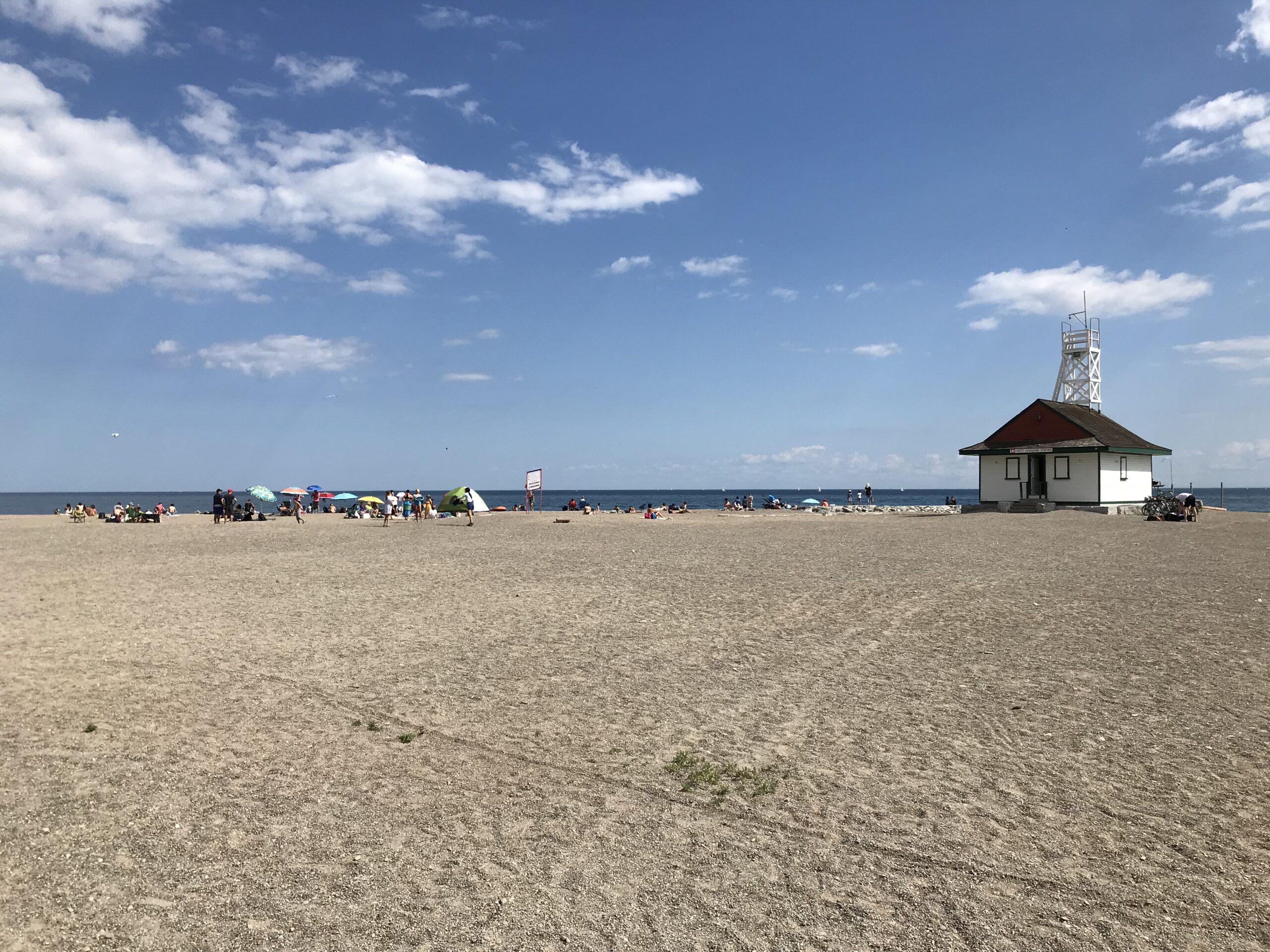
Urban Walk: Toronto Beach Walk and Glen Stewart Ravine
https://hikes.brucetrail.org/event/urban-walk-toronto-beach-walk-and-glen-stewart-ravine-2/Sorry, the registration cut-off time for this hike has been reached.Not a member? Click here to join today!Hosting Club: Toronto
Category: Urban Walk
Location (Google Maps):Meet at the Toronto Public Library, Beaches Branch, 2161 Queen Street East, Toronto, M4L 1J1
Hike Leader(s): Jeanette Vincent Click here to contact Hike Leader(s)
Pace: Moderate (3-4 km/hr)
Terrain: Flat, Level 1 (Easy – mostly on flat, well maintained trails with hard-packed surface)
Distance: 12/13kmDescription
Meet at the Toronto Public Library, Beaches Branch. My late husband Gregory Vincent grew up in the beach and we often visited and walked the area. We will walk the boardwalk and easy pathways that wind along the variety of beaches between Victoria Park Avenue to Ashbridges Bay Park. It will be an out and back route with a couple short loops with lots of views into Lake Ontario, you will see many points of interest, parks, Kew gardens, including the historic Leuty Lifesaving Station and the historic architecture of the Ashbridges Bay Wastewater Treatment Plant, the R.C. Harris Filtration Plant. I have frequent visits to this area and we will make our way across Queen St. to walk the Glen Stewart Ravine a nice ascent, taking in beautiful picturesque natural areas along Ames creek, meandering on elevated boardwalks and stair cases and then descending the area on some of the pleasing neighbourhood streets back to our start at the Beaches Branch Library. A pleasing area that offers a little something for everyone!
If you want something a little shorter you can drop-out at various areas along the way.
No dogs. Wear good footwear, bring snacks/lunch and water. Dress according to the weather conditions for the day