Join us for a hike! Registration required:
All hikes available to BTC members. Some hikes are open to non-members.
TIP: The calendar view displays up to 7 hikes on a day, but often there are more. Click “More events” to see them all.
Toronto Hike Schedule
Toronto Bruce Trail Club Registration Live Dates
Day Winter Coach Program
Registration begins one week in advance of the event departure
Day Bus Hikes
Registration begins one week in advance of the event departure
Day Coach Hikes
Registration begins 4 weeks in advance of the event departure
Day Car Hikes and Urban Hikes
Registration begins two weeks in advance of the event departure
Overnight and Weekend Trips
Registration begins 12 weeks in advance of the event departure
Val David Winter Weekend Trip
Registration begins 17 weeks in advance of the event departure
To view all Bruce Trail Conservancy Hikes click here
- 04September 4, 2021
From Lawrence Park to Castle Frank via Ravines and Park Trails (mostly)
https://hikes.brucetrail.org/event/from-lawrence-park-to-castle-frank-via-ravines-and-park-trails-mostly/Sorry, the registration cut-off time for this hike has been reached.Not a member? Click here to join today!Hosting Club: Toronto
Category: Urban Walk
Location (Google Maps): The hike will start in front of the Locke Branch of the Toronto Public Library, just across from the Lawrence Subway Station.Hike Leader(s): Wayne Crockett Click here to contact Hike Leader(s)
Pace: Moderate
Terrain: Variable
Distance: 18 kmDescription
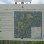
Join us for a meandering Labour Day Weekend walk from Lawrence Park via a variety of trails and ravines (with a little road walking) that will take us through Sherwood Park, Sunnybrook Park, E.T. Seton Park, Crothers Woods and the Brickworks, to finish at Castle Frank Subway Station. We will follow the trails less well trodden along the Don West Creek and Don River, avoiding the paved routes as much as possible. If there has been heavy rain prior to the walk we may have to alter the route slightly in Crothers Woods to avoid contributing to the erosion problems on the trails there. But lots of nice views and some hills to make it interesting.An early start to avoid the worst heat of the day.
What you need: Two litres of water, your lunch, bug spray and sun protection and, if the weather is dicey, a waterproof layer. Because there may be mud and there are definitely hills, hiking boots and poles are recommended.
Our Route: https://onthegomap.com/s/8fdg50se
Dropouts: There are several points along the way where you can dropout if you wish to make a shorter walk. I plan to maintain a pace of about 3.5 km per hour.
- 04September 4, 2021
Aldershot/RBG Hendrie Valley
https://hikes.brucetrail.org/event/aldershot-rbg-hendrie-valley/Sorry, the registration cut-off time for this hike has been reached.Not a member? Click here to join today!Hike open to BTC Members only.
Hosting Club: Toronto
Category: Urban Walk
Location (Google Maps): Aldershot GO Station, outside station building (near the bus loop)Hike Leader(s): Tom Swales Click here to contact Hike Leader(s)
Pace: Moderate
Terrain: Variable
Distance: 12Description
We hike from the GO Station to Hidden Valley Park and through the Hendrie Valley Sanctuary of the Royal Botanical Gardens. Due to the bridge still being out at Valley Inn Road we walk uphill beside the RBG Laking Garden to Plains Road and follow along the top of Burlington Heights with views over the the valley and Hamilton. We then hike on the Hamilton Waterfront Trail to finish the hike near the West Harbour GO Station. Return to the start or Toronto by GO Train (7 day/week service now available from this station). Mostly flat easy walking except the one hill. Optional refreshment stop at cafe or pub.$10 GO Transit Day Pass available on smartphones or can be purchased at Union Station from hike leader morning of the hike. We will take the 8:51 Niagara express train from Union Station arriving at Aldershot 9:39 AM. Anyone departing from west end of Toronto by train can take the local train departing Long Branch Station at 9:06 AM arriving at 9:50 AM.
- 06September 6, 2021
Mississauga: Credit River 3/6 Riverwood to Streetsville return Twilight Hike
https://hikes.brucetrail.org/event/mississauga-credit-river-3-6-riverwood-to-streetsville-return/Sorry, the registration cut-off time for this hike has been reached.Not a member? Click here to join today!Hosting Club: Toronto
Category: Urban Walk
Location (Google Maps): Meet on Bloor St at Green Lanes in front of the Beer Store across from Islington Subway Station by 3:30 pm for a 3:39 pm departure on MiWay Bus#26. Or if going directly to the hike, meet the rest of us by the washrooms at the Visual Arts Mississauga building at Riverwood Conservancy. Follow Riverwood Park Ln from Burnhamthorpe Rd W to the main parking lot near MacEwan Terrace Garden. Walk through the garden to Visual Arts Mississauga beside the MacEwan Barn. Try to arrive 10-15 minutes ahead of time.Hike Leader(s): Andrew Proczek Click here to contact Hike Leader(s)
Pace: Moderate
Terrain: Flat, Hilly, Variable
Distance: 12.5 kmDescription
Rescheduled hike, come and enjoy the Credit River and beautiful tranquil Riverwood Conservancy in the twilight hours as we do a there and back hike along the Culham trail to historic Streetsville, a village founded by Timothy Street in 1824, a town within a city that still retains the charms of a village. Nestled on the banks of the Credit River, Streetsville is home to the largest number of historic buildings in the city of Mississauga. Part of the route will be along an abandoned rail line from the old Barber woolen mill in Barbertown to the outskirts of Streetsville. A 20 minute rest stop in the Village Square with Murphy’s Ice Cream Parlour to tempt us and a washroom available to us from one of the eateries and nearby Starbucks before we make our way back in the waning light. Sunset will be at 7:45 pm. Bring flashlights or use the torch on your cell phones. We will finish on flatter wider trails if need be. Safety is always number one priority. - 11September 11, 2021
Forks of the Credit
https://hikes.brucetrail.org/event/forks-of-the-credit-9/Sorry, the registration cut-off time for this hike has been reached.Not a member? Click here to join today!Hosting Club: Toronto
Category: Car Hike
Location (Google Maps): Meet at the Forks of the Credit Provincial Park, parking lot off McLaren Road.Hike Leader(s): Al Brown Click here to contact Hike Leader(s)
Pace: Moderate
Terrain: Hilly, Variable
Distance: 8 KmDescription
We will complete a loop hike through the Forks of the Credit PP starting at the parking lot, following park trails as well as the main Bruce Trail and side trails. We will take a side trip to see the falls. Natural features that we will pass include one of the largest kettle lakes in southern Ontario, the Falls and the Credit River. There is a fee for parking.Directions from Brampton: north on Hwy 10 to Forks of the Credit Road. West to McLaren Road. North about 3 km to PP entrance on left. Map 15
- 11September 11, 2021
Unionville/Markham
https://hikes.brucetrail.org/event/unionville-markham/Sorry, the registration cut-off time for this hike has been reached.Not a member? Click here to join today!Hike open to BTC Members only.
Hosting Club: Toronto
Category: Urban Walk
Location (Google Maps): Unionville GO Station, outside the station building. Station is located on YMCA Blvd near Kennedy Road & Highway 407Hike Leader(s): Tom Swales, George Lennon Click here to contact Hike Leader(s)
Pace: Moderate
Terrain: Flat
Distance: 12Description
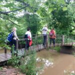
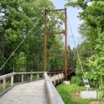
The villages of Unionville & Markham are connected by the Rouge Valley Trail System following the Rouge River and running behind the historic buildings on Main Street Unionville, by Waldon Pond in Austin Drive Park, through Milne Dam Conservation Area, and ending with a 143 metre long suspension bridge over the dam. We will walk into the village of Markham and finish with a short boardwalk trail through Tannery Pond which is close to the Markham GO Station. We begin the hike at Unionville GO Station hiking north to the historic Main Street and picking up the Rouge Valley Trail at Carlton Road. Optional stop at the Rouge River Brewing Company or local pub. Return to Toronto or the starting point by GO Train or York Region Transit bus.Terrain is easy, mostly paved path/boardwalk with some dirt trails.
On The Go Maps Link:
https://onthegomap.com/s/g5rhpj1s
Those wishing to arrive by GO Train may take the 9:14 train from Union Station (also passes by Kennedy Subway Station) arriving at 9:52. $10 GO Transit Weekend Day Pass available on Smart Phones only (not available at the ticket counter) or can be purchased from Hike Leader at Union Station morning of the hike (must travel with hike leader and expect to stay for post-hike refreshment stop).
If travelling from the north end of Toronto by public transit contact hike leader for directions from Finch Subway Station.
Bring lunch, water, insect repellent.