Join us for a hike! Registration required:
All hikes available to BTC members. Some hikes are open to non-members.
TIP: The calendar view displays up to 7 hikes on a day, but often there are more. Click “More events” to see them all.
To view all Bruce Trail Conservancy Hikes click here
Hosting Club: Iroquoia
Category: New Year’s Day Hike
Location (Google Maps): Grimsby Lions Community Pool Parking lot
1 Elm St Grimsby
Hike Leader(s): Ruth Moffatt Click here to contact Hike Leader(s)
Pace: Medium – 3 to 4 km/hr
Terrain: Easy – Mostly flat and usually good footing, Strenuous – Hilly with steep climbs and some poor footing
Distance: ~7km
Description
Join us for a New Year’s Day hike from the Grimsby pool parking lot up to Beamer’s Conservation Area to Beamer’s Falls along 40 Mile Creek and back down to parking lot.
Distance will be about 7km with the strenuous bit being the climb up the hill. Otherwise the terrain is fairly flat. Beautiful vistas across the lake, and Grimsby and on a clear day you can see the mist of Niagara Falls. Bring your camera. Please wear weather appropriate footwear and icers/crampons for your boots if icy conditions exist.
Learn all about the Bruce Trail on this hike. A draw for one membership will be held at the end of the hike. You must be present to win.
Value $50
Hosting Club: Iroquoia
Category: New Year’s Day Hike
Location (Google Maps): Dundas Valley Conservation Area, 650 Governor’s Rd., Dundas
Hike Leader(s): Phillip Armstrong Click here to contact Hike Leader(s)
Pace: Medium – 3 to 4 km/hr
Terrain: Dependent on Conditions, Moderate – Some hills and/or some poor footing
Distance: Approx. 8 – 9 km.
Description
Bring in the New Year with an energetic hike, up and down the hills of the Dundas Valley Conservation Area. Meet at 9:45 am. for a 10:00 am. start at the Trail Centre. We will be heading to Canterbury Falls, stopping at the spring for some “tasty” water, the Hermitage and more interesting spots. We will then return from the falls to the Trail Centre. (Depending on weather and trail conditions we could do a loop hike to Sherman Falls and back.) Conservation Area Pass or parking fee in effect. Bring water, a snack, poles if using and icers.
Leader: Phill Armstrong 416 895 3937 hikingrandpa@gmail.com
Hosting Club: Iroquoia
Category: New Year’s Day Hike
Location (Google Maps): Dundas Valley Conservation Area, 650 Governor’s Rd. Dundas
Hike Leader(s): Anne Armstrong Click here to contact Hike Leader(s)
Pace: Leisurely – 3km/hr or less
Terrain: Dependent on Conditions, Moderate – Some hills and/or some poor footing
Distance: Approx. 6 – 7 km.
Description
Start the new year with a lovely hike in the forests of the Dundas Valley Conservation Area. Meet at the Trail Centre, past the last parking lot and up the hill. (Bathrooms available) The hike begins at 10:30 so try to arrive about 10:15. We will complete the Sawmill Trail loop which goes through some some lovely pine and deciduous forests. Some hills. Bring water, a snack and poles if using. Icers may be necessary. (For the energetic we could complete the Deer Trail loop afterwards.) Conservation Area Pass or parking fee.
Leader: Anne Armstrong 905 617 3937 hikingrandma@gmail.com
Hosting Club: Iroquoia
Category: New Year’s Day Hike
Location (Google Maps): Dundas Valley Conservation Area
650 Governors Road, Dundas
ON, L9E 5E3
Hike Leader(s): Asia Shin Click here to contact Hike Leader(s)
Pace: Medium – 3 to 4 km/hr
Terrain: Easy – Mostly flat and usually good footing, Slippery Sections Likely
Distance: 3.4 Km
Description
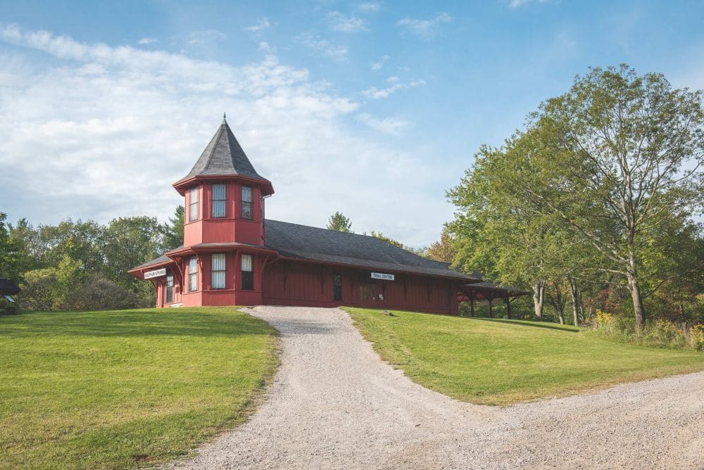
The Main Loop Trail is a journey through a mature deciduous forest hemlock groves, stream valleys, an old apple orchard and open meadow. Points of interest also include the Trail Centre, Hermitage Ruins, Sulphur Spring and Hermitage Cascade.
Depending on weather, icers may needed.
Hosting Club: Iroquoia
Category: New Year’s Day Hike
Location (Google Maps): Dundas Valley Conservation Area and Bruce Trails
Hike Leader(s): Cathie Green Click here to contact Hike Leader(s)
Pace: Medium – 3 to 4 km/hr
Terrain: Moderate – Some hills and/or some poor footing
Distance: Approximately 10kms
Description
This is a 10-12 loop hike on DVCA trails and Bruce Trail – Park at the Dundas Valley Conservation Area Trail Centre-HCA Pass or charges apply per vehicle $11. No reservations required
Meet outside at the entrance to the Trail Centre by the picnic tables by 12 noon-We will hike the Main trail to the Merrick Apple Orchard and follow a few sides trails to Artaban Road
We will then go down the road to Sherman Falls and back along the newly reinstated Bruce Trail Main Trail to Canterbury Falls and back onto the DVCA Main Trail past the Hermitage Ruins to complete this trail and return to the Trail Centre. Please wear weather appropriate clothing and foot ware – Icers recommended as parts of this trail can be icy depending on weather conditions- Pack water/snack/hiking pole/cell phone
Washrooms should be open at Trail Centre-masks required Any questions, concerns -please text or email 416-931-2095 cathiekygreen@gmail.com
Hosting Club: Iroquoia
Category: New Year’s Day Hike
Location (Google Maps): Dundas Valley Conservation Area (start at the Train station)
Hike Leader(s): Allan Meyer Click here to contact Hike Leader(s)
Pace: Medium – 3 to 4 km/hr
Terrain: Moderate – Some hills and/or some poor footing
Distance: Approx 4km
Description
A great way to clear your head and start the New Year. Please join me for a fresh holiday hike. Please wear good footwear, bring icers as the terrain could be slippery. We will do the main loop and maybe a bit more. Please meet outside at the train station.
Hosting Club: Iroquoia
Category: New Year’s Day Hike
Location (Google Maps): Kilbride Park. Parking Lot is in behind Kilbride Public School.
Hike Leader(s): Joe Borges Click here to contact Hike Leader(s)
Pace: Medium – 3 to 4 km/hr
Terrain: Dependent on Conditions, Moderate – Some hills and/or some poor footing, Slippery Sections Likely
Distance: 7.2 km
Description
This is an Iroquoia New Year’s Day Hike starting at 2:00 in the afternoon and taking about 2 hours. 2/2 in 2022:)
It’s an in & out hike where will start & end at Kilbride Park. The parking lot is in behind the school next to the Tennis Courts.
This is a short hike with deceiving elevation changes (the Lowville Valley is steep in spots), there are lots of ups and downs, roots… although not too rocky a section. It’s a very beautiful track including a boardwalk through the marsh and a neat bridge over Bronte Creek. We we then do the River & Ruin Side Trail Loop along Bronte Creek with a stop at the “Ruin” the old Cleaver Farm House. And then we’ll head back to the cars.
Speed of Hike is Moderate at 3-3.5 KM / per hour. (Although stopping for photos is allowed:)
Please ensure you check the weather and are dressed appropriately with layers. Boots are required. Poles are recommended. If weather gets cold and icy, please have crampons (ice cleats) with you. And please bring at least 1L of water, snacks/food.
Hosting Club: Iroquoia
Category: General Hike
Location (Google Maps): Hilton Falls Conservation Area Parking Lot
Hike Leader(s): Louise Langlais Click here to contact Hike Leader(s)
Pace: Brisk – 4 to 5 km/hr, Medium – 3 to 4 km/hr
Terrain: Moderate – Some hills and/or some poor footing
Distance: 12-16 km
Description
We will hike the trails in this lovely Conservation Area. Parking fee applies (unless you have a Halton Parks Pass, a great value) and you must reserve two time slots (9-11 and 11-1) in advance.
Hike Leader: Louise Langlais; Email: langlaislouise@gmail.com. Cell: 519-222-4040 on day of hike. At other times, email is the best way to contact me.
Wear appropriate quick-dry clothing and hiking boots. Bring sunscreen, insect repellent (summer), icers (winter), snacks, lunch, a personal first aid kit , and 1-2 litres of water. During COVID, also bring hand sanitizer and a face mask. For personalized driving directions, click on the hike in the BTC hike calendar, then on (Google Maps) to the right of the word Location, and your smart phone should navigate you to the correct location. Please arrive at least 15 minutes early. If you are unable to attend, please email me as long as possible in advance of the hike, or text me if it is <2 hours before the hike. There is often a waiting list, so the more advance notice you give, the better.

Hosting Club: Iroquoia
Category: Hikers R Us
Location (Google Maps): 105 Sheffield Street, paved parking lot north east of the trail head (vs the often muddy gravel parking lot adjacent to the trail)
Hike Leader(s): Louise Langlais Click here to contact Hike Leader(s)
Pace: Brisk – 4 to 5 km/hr
Terrain: Easy – Mostly flat and usually good footing
Distance: 14-20 km
Description
We will hike along the pretty Speed River, from Hespeler to Preston and back. We will likely visit a local bakery in Preston to pick up treats to supplement our picnic lunches.
Cell: 519-222-4040, on day of hike. At other times, email is the best way to contact me (use the Contact the Hike Leader feature on the BTC web page). Wear appropriate quick-dry clothing and hiking boots. Bring sunscreen, insect repellent (summer), icers (winter), snacks, lunch, a personal first aid kit , and 1-2 litres of water. During COVID, also bring hand sanitizer and a face mask. Please arrive at least 15 minutes early.
If you are unable to attend, in addition to cancelling on the BTC hikes web page, please email me the day before, or text me if it is <2 hours before the hike. There is often a waiting list, so the more advance notice you give, the better.
Hosting Club: Iroquoia
Category: Good Companions
Location (Google Maps): Shell Park. Lakeshore Road, Oakville
Hike Leader(s): Mary Rose Click here to contact Hike Leader(s)
Pace: Medium – 3 to 4 km/hr
Terrain: Easy – Mostly flat and usually good footing
Distance: 8K
Description
We will walk west beside the lake and then double back to the park before going east to Bronte Harbour. We will walk along the lake and through the neighbourhoods, until we finally mosey back to the cars. Please remember to bring icers
Hike open to BTC Members only.
Hosting Club: Iroquoia
Category: Thursday Group
Location (Google Maps): City View Park, Burlington.
Make sure you come in the South entrance to the park not the North Entrance.
Hike Leader(s): Phillip Armstrong Click here to contact Hike Leader(s)
Pace: Medium – 3 to 4 km/hr
Terrain: Easy – Mostly flat and usually good footing
Distance: 8km
Description
We will hike the main trail to Fisher’s Pond and return. We hike around the pond, stop for a snack before coming back.
There is an optional return on the Ian Reid side trail adding about 1km of hilly scenic trail below the escarpment.
Hosting Club: Iroquoia
Category: General Hike
Location (Google Maps): Bruce Trail Pear Tree parking lot on 15 Sideroad just west of Highway 25. Km 11.4 BTC Map 12.
Hike Leader(s): Stuart Law Click here to contact Hike Leader(s)
Pace: Medium – 3 to 4 km/hr
Terrain: Moderate – Some hills and/or some poor footing
Distance: 17 km
Description
Please join us on a there-and-back hike on the Hilton Falls Side Trail, Al Shaw Side Trail and part of the Main Trail. There will be quiet streams, snow-covered cedars, a secret cabin, and a brand new BTC bridge. We may even check out a flooded dam. There will be snow, ice and rocks underfoot so icers and hiking boots mandatory. Poles recommended. Please bring a snack, a lunch, water, a warm drink and a smile. Covid protocols respected. Please check BTC website for what to pack and what to wear. Please arrive at 9:00 am for a 9:15 sharp departure.
Hosting Club: Iroquoia
Category: Happy Wanderers
Location (Google Maps): Parking lot on the north side of Kortright Road W (please use the GPS coordinates vs address, it’s easier and more accurate!)
Hike Leader(s): Louise Langlais Click here to contact Hike Leader(s)
Pace: Brisk – 4 to 5 km/hr, Medium – 3 to 4 km/hr
Terrain: Moderate – Some hills and/or some poor footing
Distance: 10-14 km
Description
We will hike the trails in Preservation Park. This area includes some lovely cedar forests.
Hike open to BTC Members only.
Hosting Club: Iroquoia
Category: Good Companions
Location (Google Maps): Dundurn Park, York Rd, Hamilton (near Dundurn Castle)
Hike Leader(s): Craig Sim Click here to contact Hike Leader(s)
Pace: Medium – 3 to 4 km/hr
Terrain: Moderate – Some hills and/or some poor footing
Distance: 8k (approximate)
Description
Meet at Dundurn Park parking lot, lot farthest from Dundurn Castle. We will walk toward Princess Point via stairs, then a bit of trails there. Some flat trail and some easy hills. Good views. Bring icers for potential winter conditions. Dress in layers adequate for weather, wear hiking boots, bring water and snack. Bring mask in case needed for stairs or outhouse. Observe Covid protocols. Up to day before hike contact by email. On day of hike only cell 289-659-0065.
Hosting Club: Iroquoia
Category: Thursday Group
Location (Google Maps): Scotsdale Farm, 1365 Trafalgar Rd.
Hike Leader(s): Phillip Armstrong Click here to contact Hike Leader(s)
Pace: Leisurely – 3km/hr or less
Terrain: Moderate – Some hills and/or some poor footing
Distance: 10 km.
Description
Scotsdale Farm is a favourite destination. This hike will start at Scotsdale Farm but head west on main Bruce Trail to Duff Pit and return via the same route. Meet in the main parking lot of Scotsdale Farm at 9:45 am. for a 10:00 am. start. Bring a snack, water and poles if using. Icers may be necessary.
Leader: Phill Armstrong 416 895 3937 hikingrandpa@gmail.com
Hosting Club: Iroquoia
Category: General Hike
Location (Google Maps): Limehouse Conservation Area – southwest of km 20.4 at the baseball diamonds. Access from Fifth Line just southeast of the village of Limehouse. Red P Bruce Trail parking on the south end of the Limehouse Side Trail. BTC Map 12.
Hike Leader(s): Stuart Law Click here to contact Hike Leader(s)
Pace: Medium – 3 to 4 km/hr
Terrain: Moderate – Some hills and/or some poor footing
Distance: 18 km
Description
Join us on a winter hike from Limehouse to Speyside and back through woodland, fields and some road. We will take in side trails and the main trail as well as some unmarked trail and trail that used to be the Bruce Trail years ago. Be prepared to explore and be ready for cold temperatures, ice and rocks. Please dress accordingly. Icers mandatory. Please bring a snack, a lunch, a hot drink and a smile. Please arrive at 8:45 so as to be ready to go for 9:00 am sharp. The Hole-in-the-Wall awaits.
Hike open to BTC Members only.
Hosting Club: Iroquoia
Category: Good Companions
Location (Google Maps): Meet at the circular parking lot at RBG Arboretum.
10 Old Guelph Rd, Hamilton
Hike Leader(s): Jill Parratt Click here to contact Hike Leader(s)
Pace: Medium – 3 to 4 km/hr
Terrain: Easy – Mostly flat and usually good footing
Description
Meet at 9:15, hiking at 9:30.
Parking Fee if not a member of RBG.
We will hike a variety of trails depending on the conditions. Please bring water, snack, icers are mandatory.
Morning of the hike, you can text me at 905-399-3601.
Jill
Hosting Club: Iroquoia
Category: Thursday Group
Location (Google Maps): At the corner of Fourth Line and No 10 Side-road. From 401 and Guelph Line turn right at the church just north of the Casino.
Hike Leader(s): Phillip Armstrong Click here to contact Hike Leader(s)
Pace: Medium – 3 to 4 km/hr
Terrain: Moderate – Some hills and/or some poor footing
Distance: About 10km
Description
Enjoy a winter walk in these beautiful woods.
I will select the route based on weather and trail conditions. Please bring icers some of these rails get really ice packed.
Park as near as you can to the corner.
Hosting Club: Iroquoia
Category: Thursday Group
Location (Google Maps): Halton Agreement Forest
Hike Leader(s): Anne Armstrong Click here to contact Hike Leader(s)
Pace: Leisurely – 3km/hr or less
Terrain: Easy – Mostly flat and usually good footing
Distance: Approx. 10 km.
Description
The Halton Agreement Forest is a wonderful forest full of hiking and biking trails which can be shared. There are also areas of wetlands which feed into the Sixteen Mile Creek at Hilton Falls further south. . Meet at 9:45 am. for a 10:00 am. start on Fourth Line Nassagaweya, just north of the corner where 10th Sideroad (east of Guelph Line and north of the 401) meets Fourth Line Nassagaweya. There is a small off road parking lot on the right, north of that corner. There is also roadside parking. Bring water, a snack, poles if using and icers. **one short rocky section**
Leader: Anne Armstrong 905 617 3937 hikingrandma@gmail.com
Hosting Club: Iroquoia
Category: General Hike
Location (Google Maps): Scotsdale Farm main parking lot (BTC red “P”) off Trafalgar Road just north of Silver Creek. About 1 km northeast of km 29.7, BTC Map 13.
Hike Leader(s): Stuart Law Click here to contact Hike Leader(s)
Pace: Medium – 3 to 4 km/hr
Terrain: Moderate – Some hills and/or some poor footing, Slippery Sections Likely
Distance: 18 kms
Description
Join us for a wintry hike in the snow at Scotsdale Farm as we venture to the Walking Fern Side Trail and back in a loop encompassing the Bennett Heritage Side Trail, the Roberts Side Trail and portions of the Main Trail. Waterfalls, streams, cedars, lookouts, bridges and rocks. The going will be more strenuous in the snow but highly rewarding. Please dress for the weather in layers as suggested on the BTC website for winter hiking. Icers mandatory. Poles recommended. Please bring two hot beverages, a snack, a lunch, your own first aid kit, two sets of mitts, hand warmers and a smile. Please meet at 8:45 am and be ready to go for a 9:00 am sharp start.
Hosting Club: Iroquoia
Category: General Hike
Location (Google Maps): Park at Fletcher Creek Ecological Preserve on Concession 7 just north of Gore Rd , Puslinch
HCA passes can be used or 7.50 per vehicle
Hike Leader(s): Cathie Green Click here to contact Hike Leader(s)
Pace: Medium – 3 to 4 km/hr
Terrain: Moderate – Some hills and/or some poor footing
Distance: Approximately 10kms
Description
This is the rescheduled Jan 17 hike(cancelled due to blizzard) Note new start time 10:30 am
Fletcher’s Creek Preserve is an abandoned quarry site that has been rehabilitated and is located at the headwaters of the Spencer Creek watershed
We will take a loop hike through the preserve as well as an adjacent trail that also was part of the quarry back in the day-lots of local history and old stories associated with this area
Suitable for snowshoeing if there is enough snow-Wear hiking or winter boots, Icers, hiking pole, water snack/lunch, cell phone, and appropriate clothing for the weather
Please feel free to call or text me if you have any concerns or questions Cathie 416-931-2095 cathiekygreen@gmail.com
Hosting Club: Iroquoia
Category: Good Companions
Location (Google Maps): Chedoke Golf Course Parking Lot
Hike Leader(s): Ted Bossence Click here to contact Hike Leader(s)
Pace: Medium – 3 to 4 km/hr
Terrain: Dependent on Conditions, Moderate – Some hills and/or some poor footing, Slippery and Steep Sections, Slippery Sections Likely
Distance: 7.5 km
Description
We will head east from the Chedoke Golf Course parking lot along the radial line and then onto the Bruce Trail up the escarpment. We will need to cross busy Beckett’s Drive/Queen Street Hill. We will then follow the Bruce Trail to the top of the escarpment and then descending to the city streets and return via the tree lined streets to the radial trail and the golf course parking lot.
In case of too much snow or other impediments on the trail, we will take different routes through the city streets. without the ascent and descent of the escarpment.
Icers are essential. Covid precautions in effect. Walk will be cancelled in case of poor weather/driving conditions (please check your email the evening before).
Please arrive 15 minutes before the start time and we will start walking at 10:00 am sharp! Please inform me by email at tedbossence@sympatico.ca if you cancel after the registration cut-off time.
Hosting Club: Iroquoia
Category: Thursday Group
Location (Google Maps): Meet at 9:45 at the south parking lot at City View Park, Burlington, located at Kerns Road and Highway #5.
Hike Leader(s): Lynn Sullivan Click here to contact Hike Leader(s)
Pace: Medium – 3 to 4 km/hr
Terrain: Moderate – Some hills and/or some poor footing
Distance: 9-10 km
Description
We will hike from City View Park to Grindstone Creek on mostly the main Bruce Trail. Please dress with layers and bring water, snacks and icers. Poles are also helpful.
Hike leader Lynn Sullivan. Call or text 905-330-4145 the morning of the hike for last minute cancellations.