Join us for a hike! Registration required:
All hikes available to BTC members. Some hikes are open to non-members.
TIP: The calendar view displays up to 7 hikes on a day, but often there are more. Click “More events” to see them all.
To view all Bruce Trail Conservancy Hikes click here- 26December 26, 2021No events
- 27December 27, 2021No events
- 28December 28, 2021No events
- 29December 29, 2021
Crawford Lake/Rattlesnake Point CA's
https://hikes.brucetrail.org/event/crawford-lake-rattlesnake-point-cas/Sorry, the registration cut-off time for this hike has been reached.Not a member? Click here to join today!Hike open to BTC Members only.
Hosting Club: Iroquoia
Category: Hikers R Us
Location (Google Maps): Crawford Lake CA: enter from Conservation Rd (formerly Steeles Ave), just east of Guelph Line; parking area closest to gatehouse.Hike Leader(s): Ronald Granger Click here to contact Hike Leader(s)
Pace: Brisk – 4 to 5 km/hr, Medium – 3 to 4 km/hr
Terrain: Moderate – Some hills and/or some poor footing, Slippery Sections Likely
Distance: 14 kmDescription
Meet at Crawford Lake Conservation Area parking area nearest to the gatehouse. Conservation Authority reservation fee system is in effect. Make two consecutive Crawford Lake CA reservations beginning at 9:00 one week before the hike.We will take the Crawford Lake Side Trial to the Main Trail and hike past the lookout and then down into the Nassagaweya Canyon and up to the top of the Rattlesnake Point CA ridge. We will return to our cars via blue and white trails. This hike includes steep inclines in and out of the Nassagaweya Canyon. Ice and snow could make the trail treacherous.
Dress appropriately for the weather and for icy or snow-covered trails. Icers/micro spikes or snowshoes may be required. Bring food and water, hiking boots, cold weather outerwear, personal first aid kit. No dogs please.
Direct inquiries to Victoria at victoriaahb@yahoo.ca at least 12 hours prior to the hike.
Please arrive 15 minutes before the hike start time of 9:30 AM. Register using the hiking schedule. Cancellations the morning of the hike please call 905-257-6815.Brantford Waterworks Park
https://hikes.brucetrail.org/event/brantford-waterworks-park-2/Sorry, the registration cut-off time for this hike has been reached.Not a member? Click here to join today!Hosting Club: Iroquoia
Category: Good Companions
Location (Google Maps): Brantford Glenhurst Gardens upper parking lot. 20 Ava Rd BrantfordHike Leader(s): Lorraine Sherred Click here to contact Hike Leader(s)
Pace: Medium – 3 to 4 km/hr
Terrain: Easy – Mostly flat and usually good footing
Distance: 8to 10 KmDescription
several loops along river in Waterworks Park. - 30December 30, 2021
RBG North Shore Trail
https://hikes.brucetrail.org/event/rbg-north-shore-trail-4/Sorry, the registration cut-off time for this hike has been reached.Not a member? Click here to join today!Hosting Club: Iroquoia
Category: Thursday Group
Location (Google Maps): We will meet at the circular parking lot at the RBG Arboretum (Nature Center).Hike Leader(s): Linda Robinson Click here to contact Hike Leader(s)
Pace: Medium – 3 to 4 km/hr
Terrain: Easy – Mostly flat and usually good footing
Distance: 8 kmDescription
Meet at the RBG Arboretum (Nature Center) parking lot at 9:45 AM for a 10 AM start. East hike, a few hills. Bring water, snack and icers, if there is snow/ice on the ground. - 31December 31, 2021
Speed River Trail
https://hikes.brucetrail.org/event/speed-river-trail/Sorry, the registration cut-off time for this hike has been reached.Not a member? Click here to join today!Hosting Club: Iroquoia
Category: General Hike
Location (Google Maps): RR32, just south of the bridgeHike Leader(s): Louise Langlais Click here to contact Hike Leader(s)
Pace: Brisk – 4 to 5 km/hr, Medium – 3 to 4 km/hr
Terrain: Dependent on Conditions, Easy – Mostly flat and usually good footing
Distance: 12-15 kmDescription
We will hike along the Speed River, from RR 32 to Blackbridge Road. We will cross the bridge and also hike a short while on the opposite side of the river. We will then re-trace our steps back to our cars. We will be alert for ducks and other birds that frequent this area. - 01January 1, 2022
New Year’s Day Hike - Grimsby
https://hikes.brucetrail.org/event/new-years-day-hike-grimsby/Sorry, the registration cut-off time for this hike has been reached.Not a member? Click here to join today!Hosting Club: Iroquoia
Category: New Year’s Day Hike
Location (Google Maps): Grimsby Lions Community Pool Parking lot
1 Elm St GrimsbyHike Leader(s): Ruth Moffatt Click here to contact Hike Leader(s)
Pace: Medium – 3 to 4 km/hr
Terrain: Easy – Mostly flat and usually good footing, Strenuous – Hilly with steep climbs and some poor footing
Distance: ~7kmDescription
Join us for a New Year’s Day hike from the Grimsby pool parking lot up to Beamer’s Conservation Area to Beamer’s Falls along 40 Mile Creek and back down to parking lot.
Distance will be about 7km with the strenuous bit being the climb up the hill. Otherwise the terrain is fairly flat. Beautiful vistas across the lake, and Grimsby and on a clear day you can see the mist of Niagara Falls. Bring your camera. Please wear weather appropriate footwear and icers/crampons for your boots if icy conditions exist.
Learn all about the Bruce Trail on this hike. A draw for one membership will be held at the end of the hike. You must be present to win.
Value $50To the Falls and Back
https://hikes.brucetrail.org/event/to-the-falls-and-back/Sorry, the registration cut-off time for this hike has been reached.Not a member? Click here to join today!Hosting Club: Iroquoia
Category: New Year’s Day Hike
Location (Google Maps): Dundas Valley Conservation Area, 650 Governor’s Rd., DundasHike Leader(s): Phillip Armstrong Click here to contact Hike Leader(s)
Pace: Medium – 3 to 4 km/hr
Terrain: Dependent on Conditions, Moderate – Some hills and/or some poor footing
Distance: Approx. 8 – 9 km.Description
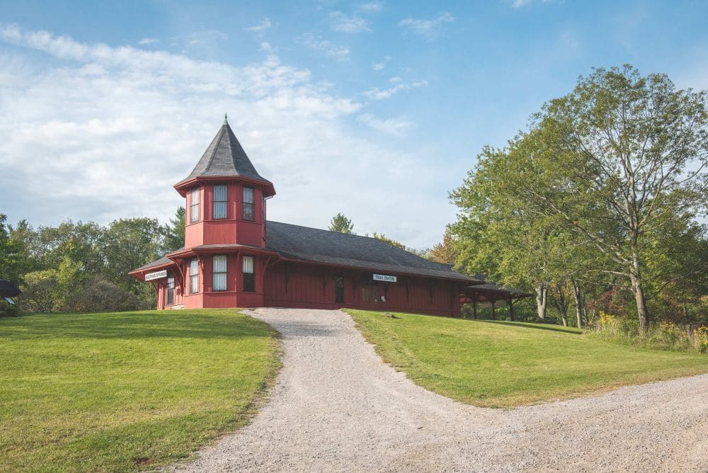
Bring in the New Year with an energetic hike, up and down the hills of the Dundas Valley Conservation Area. Meet at 9:45 am. for a 10:00 am. start at the Trail Centre. We will be heading to Canterbury Falls, stopping at the spring for some “tasty” water, the Hermitage and more interesting spots. We will then return from the falls to the Trail Centre. (Depending on weather and trail conditions we could do a loop hike to Sherman Falls and back.) Conservation Area Pass or parking fee in effect. Bring water, a snack, poles if using and icers.
Leader: Phill Armstrong 416 895 3937 hikingrandpa@gmail.comWinter in the Forest
https://hikes.brucetrail.org/event/winter-in-the-forest/Sorry, the registration cut-off time for this hike has been reached.Not a member? Click here to join today!Hosting Club: Iroquoia
Category: New Year’s Day Hike
Location (Google Maps): Dundas Valley Conservation Area, 650 Governor’s Rd. DundasHike Leader(s): Anne Armstrong Click here to contact Hike Leader(s)
Pace: Leisurely – 3km/hr or less
Terrain: Dependent on Conditions, Moderate – Some hills and/or some poor footing
Distance: Approx. 6 – 7 km.Description
Start the new year with a lovely hike in the forests of the Dundas Valley Conservation Area. Meet at the Trail Centre, past the last parking lot and up the hill. (Bathrooms available) The hike begins at 10:30 so try to arrive about 10:15. We will complete the Sawmill Trail loop which goes through some some lovely pine and deciduous forests. Some hills. Bring water, a snack and poles if using. Icers may be necessary. (For the energetic we could complete the Deer Trail loop afterwards.) Conservation Area Pass or parking fee.
Leader: Anne Armstrong 905 617 3937 hikingrandma@gmail.comNew Year's Day at Dundas Valley Conservation Area: Main Loop Trail
https://hikes.brucetrail.org/event/new-years-day-at-dundas-valley-conservation-area-main-loop-trail/Sorry, the registration cut-off time for this hike has been reached.Not a member? Click here to join today!Hosting Club: Iroquoia
Category: New Year’s Day Hike
Location (Google Maps): Dundas Valley Conservation Area
650 Governors Road, Dundas
ON, L9E 5E3Hike Leader(s): Asia Shin Click here to contact Hike Leader(s)
Pace: Medium – 3 to 4 km/hr
Terrain: Easy – Mostly flat and usually good footing, Slippery Sections Likely
Distance: 3.4 KmDescription
The Main Loop Trail is a journey through a mature deciduous forest hemlock groves, stream valleys, an old apple orchard and open meadow. Points of interest also include the Trail Centre, Hermitage Ruins, Sulphur Spring and Hermitage Cascade.Depending on weather, icers may needed.
Noon New Year's Day hike at DVCA
https://hikes.brucetrail.org/event/noon-new-years-day-hike-at-dvca/Sorry, the registration cut-off time for this hike has been reached.Not a member? Click here to join today!Hosting Club: Iroquoia
Category: New Year’s Day Hike
Location (Google Maps): Dundas Valley Conservation Area and Bruce TrailsHike Leader(s): Cathie Green Click here to contact Hike Leader(s)
Pace: Medium – 3 to 4 km/hr
Terrain: Moderate – Some hills and/or some poor footing
Distance: Approximately 10kmsDescription
This is a 10-12 loop hike on DVCA trails and Bruce Trail – Park at the Dundas Valley Conservation Area Trail Centre-HCA Pass or charges apply per vehicle $11. No reservations requiredMeet outside at the entrance to the Trail Centre by the picnic tables by 12 noon-We will hike the Main trail to the Merrick Apple Orchard and follow a few sides trails to Artaban Road
We will then go down the road to Sherman Falls and back along the newly reinstated Bruce Trail Main Trail to Canterbury Falls and back onto the DVCA Main Trail past the Hermitage Ruins to complete this trail and return to the Trail Centre. Please wear weather appropriate clothing and foot ware – Icers recommended as parts of this trail can be icy depending on weather conditions- Pack water/snack/hiking pole/cell phone
Washrooms should be open at Trail Centre-masks required Any questions, concerns -please text or email 416-931-2095 cathiekygreen@gmail.com
Dundas Valley Main Loop and maybe more
https://hikes.brucetrail.org/event/dundas-valley-main-loop-and-maybe-more-4/Sorry, the registration cut-off time for this hike has been reached.Not a member? Click here to join today!Hosting Club: Iroquoia
Category: New Year’s Day Hike
Location (Google Maps): Dundas Valley Conservation Area (start at the Train station)Hike Leader(s): Allan Meyer Click here to contact Hike Leader(s)
Pace: Medium – 3 to 4 km/hr
Terrain: Moderate – Some hills and/or some poor footing
Distance: Approx 4kmDescription
A great way to clear your head and start the New Year. Please join me for a fresh holiday hike. Please wear good footwear, bring icers as the terrain could be slippery. We will do the main loop and maybe a bit more. Please meet outside at the train station.HIKE-IN-2-2022 / RIVER & RUIN
https://hikes.brucetrail.org/event/hike-in-2-2022-river-ruin/Sorry, the registration cut-off time for this hike has been reached.Not a member? Click here to join today!Hosting Club: Iroquoia
Category: New Year’s Day Hike
Location (Google Maps): Kilbride Park. Parking Lot is in behind Kilbride Public School.Hike Leader(s): Joe Borges Click here to contact Hike Leader(s)
Pace: Medium – 3 to 4 km/hr
Terrain: Dependent on Conditions, Moderate – Some hills and/or some poor footing, Slippery Sections Likely
Distance: 7.2 kmDescription
This is an Iroquoia New Year’s Day Hike starting at 2:00 in the afternoon and taking about 2 hours. 2/2 in 2022:)It’s an in & out hike where will start & end at Kilbride Park. The parking lot is in behind the school next to the Tennis Courts.
This is a short hike with deceiving elevation changes (the Lowville Valley is steep in spots), there are lots of ups and downs, roots… although not too rocky a section. It’s a very beautiful track including a boardwalk through the marsh and a neat bridge over Bronte Creek. We we then do the River & Ruin Side Trail Loop along Bronte Creek with a stop at the “Ruin” the old Cleaver Farm House. And then we’ll head back to the cars.
Speed of Hike is Moderate at 3-3.5 KM / per hour. (Although stopping for photos is allowed:)
Please ensure you check the weather and are dressed appropriately with layers. Boots are required. Poles are recommended. If weather gets cold and icy, please have crampons (ice cleats) with you. And please bring at least 1L of water, snacks/food.