Dufferin Hi-Land, Map 19. Meet at the Mono Community Centre parking lot. Take Mono Centre Road east from Hwy 10 and look for the Community Centre on your right as you approach the stop sign in Mono Centre.
Pace: Leisurely Terrain: Dependent on Conditions Distance: 4.8 or 7.5 km
Description
Our Annual New Years Day hike returns! Join us for a “day after the night before” hike to clear your head with a little exercise, fresh air and great company. Hot beverages and snacks available after the hike. Contributions to the snack table welcome!
Snow shoes or icers may be required, depending on conditions. Contact the hike leader if in doubt.
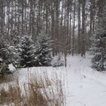
Hosting Club: Dufferin Hi-Land Category: Tuesday Hike Location (Google Maps): Dufferin Hi-Land Section, Map 20. Meet at roadside parking on east side of 2nd Line EHS, Mulmur (Km 24.2)
Pace: Leisurely Terrain: Slippery and Steep Sections, Moderate Distance: Longer hike: 5.8 km; Shorter hike: 3.5 km
Description We will hike a loop consisting of the Main Trail to the Oliver Creek Side Trail loop. The short hike will cut off on the 2nd Line EHS Side Trail and return to the cars on the road. Bring icers and/or snowshoes.
Hosting Club: Dufferin Hi-Land Category: Cancelled Location (Google Maps): Dufferin Hi-Land Section, Map 19. Meet at Split Rock Narrows parking lot on 2nd Line, Mono, 1.5 km north of 25 Sideroad.
Hosting Club: Dufferin Hi-Land Category: Cancelled Location (Google Maps): Dufferin Hi-Land Section, Map 19. Meet at Mono Community Centre hiker parking area off of 2nd Line Mono at south end of Mono Centre village.
Pace: Leisurely Terrain: Moderate Distance: Long hike: 5.9 km; Short: 3.8 km
Description Both hikes will take the Laidlaw Side Trail to Main Trail, then around the South Outlier loop to Main Trail and Laidlaw Side Trail. The longer hike will then do a loop hike of the Turnbull Side Trail. The shorter hike will continue directly to the parking lot on Laidlaw Side Trail.
Hosting Club: Dufferin Hi-Land Category: General Hike Location (Google Maps): Second Line and 15th Sideroad in Mulmur Ontario. From Orangeville, head north on hwy #10 to hwy #89. Turn left and head west to county road #124. Turn left and head north to 15 sideroad. Turn right and follow to 2nd line.
Pace: Leisurely Terrain: Dependent on Conditions, Moderate, Strenuous Distance: 6km
Description We will be exploring the winter wonders that the Pine River Nature Reserve offers.
This is a snowshoe hike so please be sure to bring your snowshoes. Should the weather not behave and snow is not in abundance, we will still do the hike but icer’s would be recommended in this case as there is sure to still be icy patches within the reserve.
Hosting Club: Dufferin Hi-Land Category: Cancelled Location (Google Maps): Meet at roadside parking on the north-west side of Castlederg Rd at the Humber River bridge, midway between The Gore Rd and Hwy 50.
Pace: Leisurely Terrain: Easy, Slippery Sections Likely Distance: Long hike: 6 km; Short hike 3 km
Description We will hike north for about 3 km and back, depending on conditions. The short hike will turn back after about 1.5 km. Bring icers and snowshoes.
Hosting Club: Dufferin Hi-Land Category: General Hike Location (Google Maps): Dundas Valley Trail Parking: From Hwy 403 going west up the escarpment past Hamilton, take Exit 64 following Mohawk /Rousseau road north. Turn right on Wilson St, continuing for 0.75 km to the next traffic light. Turn left on Montgomery Dr, then right following Old Dundas Valley Road down a steep hill, then left on Lions Club Road. Continue for about 1.3 km on Lions Club Road to park gates, and then through gates to parking further down the lane. Parking fees (currently $11/day) apply and payable by credit card.
Pace: Medium Terrain: Moderate, Slippery and Steep Sections Distance: 8 to 15km, depending on weather conditions
Description We’ll do a circular hike through the Dundas Valley Conservation area taking in various trails, Canterbury and Sherman waterfalls, and a few other streams and hills. Icers or snowshoes will likely be required and requirements will be confirmed a few days before the hike.