Join us for a hike! Registration required:
All hikes available to BTC members. Some hikes are open to non-members.
TIP: The calendar view displays up to 7 hikes on a day, but often there are more. Click “More events” to see them all.
Dufferin Hi-Land Hike Schedule
To view all Bruce Trail Conservancy Hikes click here
- 01January 1, 2021
CANCELLED -Dufferin Hi-Land Annual New Years Day Hike
https://hikes.brucetrail.org/event/dufferin-hi-land-annual-new-years-day-hike-2/Sorry, the registration cut-off time for this hike has been reached.Not a member? Click here to join today!Hosting Club: Dufferin Hi-Land
Category: Cancelled
Location (Google Maps): Dufferin Hi-Land, Map 19. Meet at the Mono Community Centre parking lot. Take Mono Centre Road east from Hwy 10 and look for the Community Centre on your right as you approach the stop sign in Mono Centre.
Hike Leader(s): Les Babbage Click here to contact Hike Leader(s)
Pace: Leisurely
Terrain: Moderate, Slippery Sections Likely
Distance: 4.8 or 7.5 kmDescription
Join us in 2022 when this event returns!
- 05January 5, 2021
CANCELLED - Boyne Valley/Mulmur Lookout
https://hikes.brucetrail.org/event/boyne-valley-mulmur-lookout-2/Sorry, the registration cut-off time for this hike has been reached.Not a member? Click here to join today!Hosting Club: Dufferin Hi-Land
Category: Cancelled
Location (Google Maps): Dufferin Hi-Land, Map 20. Meet at intersection of 8 Sideroad and 2nd Line Mulmur (Km 23.8). From Hwy 89, drive north on 1st Line Mulmur for about 4km. Turn right/east on 8 Sideroad. Park on the south side of 2nd Line, just before the road bends from 8 Sideroad to become 2nd Line.
Hike Leader(s): Les Babbage;Inge Eckerich;Bob Slack Click here to contact Hike Leader(s)
Pace: Leisurely
Terrain: Slippery and Steep Sections
Distance: 6.6 or 4.2 kmDescription
We will hike south on the Main Trail to the stile at 1st Line (Km 20.5) and back. The shorter hike will turn back at the Mulmur Lookout Side Trail (Km 21.8). Bring icers, water, snacks. Snowshoes may be required. - 12January 12, 2021
CANCELLED - Boyne Valley/Oliver Creek Loop
https://hikes.brucetrail.org/event/boyne-valley-oliver-creek-loop/Sorry, the registration cut-off time for this hike has been reached.Not a member? Click here to join today!Hosting Club: Dufferin Hi-Land
Category: Cancelled
Location (Google Maps): Dufferin Hi-Land Section, Map 20. Meet on 2nd Line Mulmur, about .3 km north of 8 Sideroad (Km 23.80), where the Main Trail leaves the roadway to the east. From Hwy 89, drive north on 1st Line Mulmur for about 4 km. Turn right/east onto 8 Sideroad, around the bend onto 2nd Line and continue north for .3 km to roadside parking.
Hike Leader(s): Les Babbage;Inge Eckerich; Bob Slack Click here to contact Hike Leader(s)
Pace: Leisurely
Terrain: Slippery Sections Likely
Distance: 5.7 km or 2.7 kmDescription
We will hike the Main Trail through the Boyne Valley and Walkers Woods to the second intersection with Oliver Creek Side Trail and loop back by way of Oliver Creek and the Main Trail. Snowshoes may be required. Bring icers, water, snacks. - 19January 19, 2021
CANCELLED - Hockley Valley/Tom East Loop
https://hikes.brucetrail.org/event/hockley-valley-tom-east-loop/Sorry, the registration cut-off time for this hike has been reached.Not a member? Click here to join today!Hosting Club: Dufferin Hi-Land
Category: Cancelled
Location (Google Maps): Caledon Hills, Map 18. Meet at Hockley Rd parking lot on the north side of Hockley Rd, 250 metres east of 2nd Line (near Km 61.3).
Hike Leader(s): Les Babbage;Inge Eckerich;Bob Slack Click here to contact Hike Leader(s)
Pace: Leisurely
Terrain: Slippery and Steep Sections
Distance: 5.6 or 2.5 kmDescription
We will hike a loop consisting of the Hockley Rd and Tom East Side Trails and the Main Trail. The shorter hike will turn back where the Tom East trail turns sharply to the east. Bring icers, water, snacks. Snowshoes may be required. - 23January 23, 2021
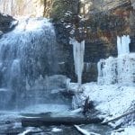
Dundas Valley Winter Waterfall Hike
https://hikes.brucetrail.org/event/dundas-valley-winter-waterfall-hike-2/Sorry, the registration cut-off time for this hike has been reached.Not a member? Click here to join today!Hosting Club: Dufferin Hi-Land
Category: General Hike
Location (Google Maps): Sherman Falls Parking, Artaban Rd, Dundas Valley
Hike Leader(s): Gilles P Gagnon Click here to contact Hike Leader(s)
Pace: Medium
Terrain: Moderate, Slippery and Steep Sections
Distance: 10 to 13 km, depending on conditionsDescription
We’ll hike to Tiffany/ Sherman Falls and back, then take a loop within Dundas Valley, taking in Canterbury Falls. Bring icers or snowshoes depending on conditions. Hiking poles recommended.Directions: From Hwy403 going west up the escarpment, take Exit 64 following Mohawk/Rousseau Rd North (right). Continue to T junction, then turn right on Wilson St., then left at the next traffic light on Montgomery Dr, then right as the Stop, following Old Dundas Rd down a steep hill, take the next left on Lions Club Rd, then the next right on Artaban Road.
- 26January 26, 2021
CANCELLED - Mono Cliffs/South Outlier/Turnbull Side Trail
https://hikes.brucetrail.org/event/mono-cliffs-south-outlier-turnbull-side-trail/Sorry, the registration cut-off time for this hike has been reached.Not a member? Click here to join today!Hosting Club: Dufferin Hi-Land
Category: Cancelled
Location (Google Maps): Dufferin Hi-Land Section, Map 19. Meet at Mono Community Centre parking lot on the east side of Mono Centre Rd as you enter Mono Centre.
Hike Leader(s): Les Babbage;Inge Eckerich;Bob Slack Click here to contact Hike Leader(s)
Pace: Leisurely
Terrain: Slippery Sections Likely
Distance: 7.5 or 5.4 kmDescription
We will hike a loop consisting of the Laidlaw Side Trail, Main Trail and South Outlier Side Trail. The short hike will return directly to the parking lot. The longer hike will visit the Turnbull Side Trail loop. Bring icers, water, snacks. Snowshoes may be required.